Search the Community
Showing results for tags 'noreaster'.
-
Go!
- 1,188 replies
-
- 1
-

-
A fall to remember? Post your obs and discussion here.
- 1,105 replies
-
- tropics
- heavy rainfall
-
(and 5 more)
Tagged with:
-
The downward slide into winter begins. Post your Obs/Discussions here.
-
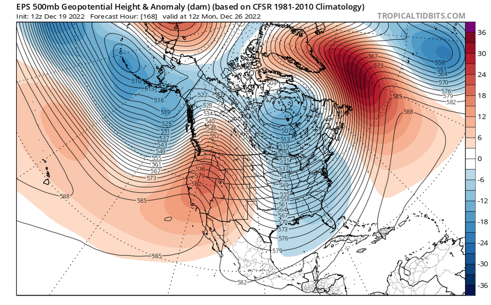
I know the models aren’t showing hits yet, but the 500s tell a different story. This look is REALLY close to something big for the shortwave diving down for the 27th threat after the big cutter. The western ridge axis is still quite far west, but it’s not offshore anymore. The NAO isn’t super negative but it is still negative which argues against a progressive solution (why I’m not buying the wave spacing issues, I’m thinking the northern energy will be much slower to enter the country). If that ridge pokes up a bit more and links up with the decaying block, I bet we will start seeing big solutions on the models. It’s really not far from doing so, it only needs a couple minor adjustments. This is a legitimate big dog Miller B nor’easter threat. That northern stream energy is quite powerful, and the teleconnections are in a transitory state.
-
The decline into winter continues. What will October bring? Post your discussions and observations here.
- 1,381 replies
-
- 3
-

-

-
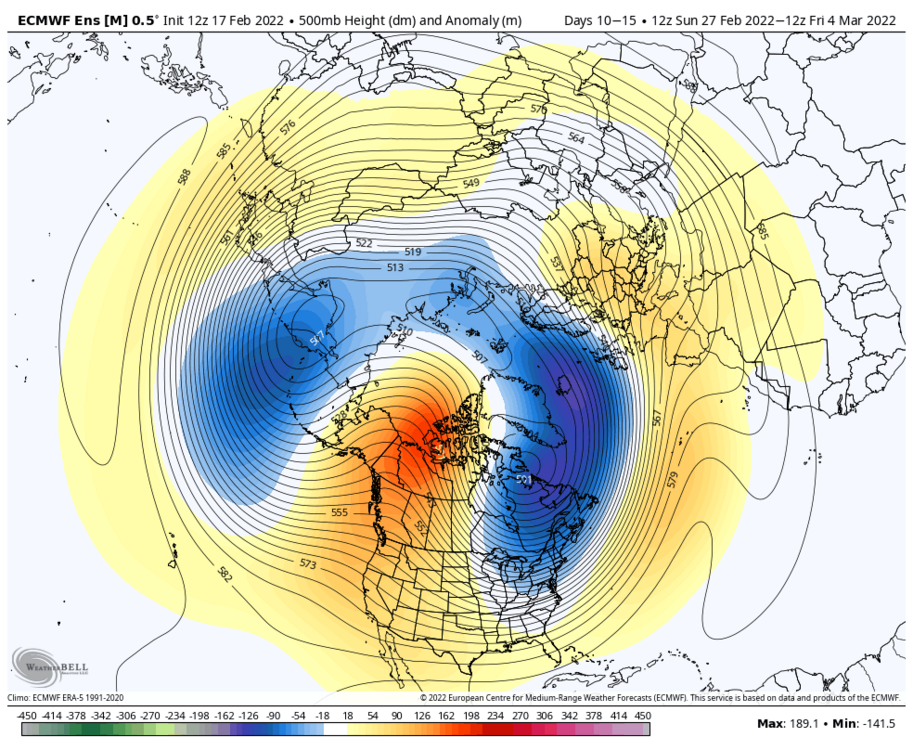
This thread will encompass the late winter to early spring window. The models have shifted away from a mild pattern for late Feb into early March to a much colder and potentially stormy pattern. My early thoughts for the late Feb period is that it does not favor an all snow event for SNE, due to the SE ridge in place and warming mid levels. However, there is a strong high to the north, so I do think there could be a significant (6+) front end before a changeover to sleet or ice. I’d favor north of Boston for the biggest snows, with Boston south getting a decent front end before a changeover. I do not think this will be a huge storm, 6-12 inches. Closer to 6 for the areas that mix and 12 for the areas that stay all snow. Although for the late Feb pattern there aren’t any signs of a huge storm, there is the possibly that if things break right we could get 2 or even 3 waves due to the energy out west ejecting in pieces, not all at once (if it does eject all at once, it would likely cut inland). We do not want a phase here). What once looked like a torch turned into a very interesting period with snow sleet and ice all on the table. Now the period that really interests me is early to mid March. I have read concerns about suppression and have seen comparisons to March 2014, but in my opinion this is unlikely. Why? In 2014, the vortex was over Maine. On the EPS, the vortex is east-central Canada, which is several hundred miles north of 2014. This argues that storms would have more room to come north than 2014. We also have an extremely amplified western ridge axis. The ridge axis is centered over Washington state and is poking up all the way to Alaska. Ideal for east coast cyclogenesis is over Montana, so if anything it’s a little west of ideal. This looks very similar to the Jan pattern but if anything, the western ridge is even more amplified. This suggests that any northern energy has room to dig very far south, enough to tap into gulf moisture and phase with any southern energy available. The biggest and most important difference is it is early March, not early January climo. This is double edged, as the milder late winter waters clashing with the arctic airmass in place would encourage more explosive cyclogenesis, leading to a stronger low and farther NW low. However, if the track is too far NW it wouldn’t take as much to bring in warm air and flood the coast with rain (like the early Feb event last year, where Boston didn’t get much and interior areas got slammed). Rain snow lines are absolutely a concern, so I would like to see a Miller B or hybrid system more so than a Miller A for my area, but either way the potential for a big storm is there. In my opinion, this is the most explosive pattern I have seen since March 2018, and honestly has the potential to be even more explosive than that. We have an extremely amplified and western ridge displaced very far west combined with a piece of the polar vortex over central canada. We also have a weak east based La Niña currently in place. East based La Niña climo tends to be favorable in March, more so than western or central based events. my bold call: for many areas, there will be a storm in early-mid March that ends up being STRONGER than the January blizzard, and delivers even more snow. The question is, what happens in mid to late March? We are seeing signs that the polar vortex could finally start to rapidly weaken, which could lead to this favorable period being extended all the way to early April. If that happens, I believe we will get 2-3 big ones (12+) with possible a couple moderate (6+) ones mixed in as well. That is the upside with this pattern. Will it happen? It may not, but even if it doesn’t I am still convinced that the early-mid March period will deliver, and could even deliver 2 big ones, yes even with a positive NAO. Then we have the mid March to early April period that could be interesting as well. The thing about the near record strong polar vortex we have right now is that when it does get disrupted and is displaced or even split (unlikely, I’m leaning displacement right now), all that cold air bottled up over the North Pole is going to come crashing south. This is an anomalous event, so we could see some crazy ass shit. A lot of you will probably think I’m going off the deep end here, but I’m just gonna say it. I think there will be a window in late March early April, with a much higher probability than normal for an April snowstorm this year. If I’m wrong I’m wrong, but when we combine the already colder than average Canadian airmass in place with a record strong vortex being possibly displaced or split, if it is displaced to this side of the globe, April 1997 becomes an analog (correct me if I am wrong, but I read that this was also a strong PV winter). This does not mean something as extreme, but a muted version of that? Hell yeah! Will the PV be displaced to this side of the globe? It may not, but I believe it will due to the polar vortex having a tendency to elongate and stretch toward this side of the globe this year, sunlike previous strong PV winters like 2020.
-
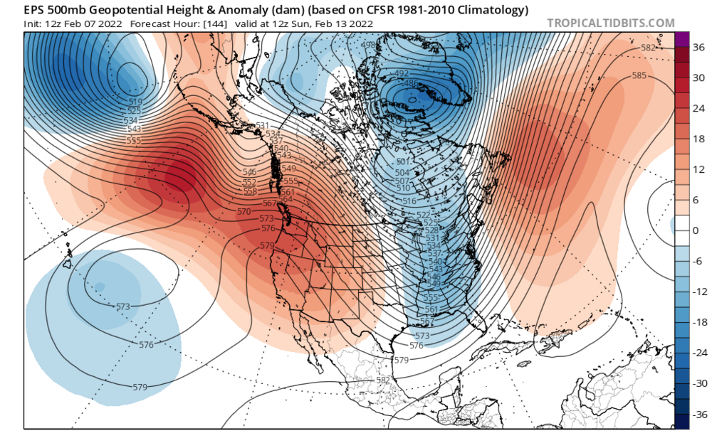
I have been watching this window on the models for a week now. The models showed the signal far out, but as we got closer they started burying the southern energy out west. However, the players on the field never left. Like the during the late January blizzard, we have a monster ridge out west with a deep trough in the east. The 12z eps doesn’t quite dig the energy enough to produce a big storm, but the following factors combined with continued favorable trends on the models tonight has me convinced there will be a big storm during the Feb 13-14th timeframe. Pros and cons: pros: 1. Arctic air, 540 line is as far south as the southeastern United States, and there is a strong high to the north. 2. Ridge axis is centered over Washington, which is VERY far west, and argues for a more western low 3. Atlantic ridging Cons: 1. Lack of North Atlantic blocking 2. Timing of the energy isn’t great I am convinced that the models are underestimating how much the northern energy will dig, and that the models will continue to trend more and more amplified. The stronger and farther west the northern energy digs, the more time the southern energy will have to get ahead of the northern energy, and the farther west the phase will happen. If the northern branch digs as much as I think it will, it will phase early enough that we will see a closed off strengthening upper low, which would slow the storm down and allow it to deepen rapidly. The track would also be farther west than what the models have right now, and would result in heavy snow and blizzard conditions in eastern mass. Despite the surface not reflecting it, models have trended more amplified with the western ridge, with a northern branch digging more and farther west.
-
March 11th 2017 605pm entry: Very cold air mass overhead the Northeastern US tonight. temperatures for Sunday morning lows are around 10-12F over the Cape. Forecasted temperatures won't break 25 the next two days Sunday and Monday. This arctic air mass will be the reason we can expect a snowstorm to occur some time Monday night through Wednesday morning depending upon if the storm slows down at all, right now the 12z and 18z runs today show a progressive but easterly track with less phasing, although I don't think this is about a less of a phase. While common knowledge dictates that the stronger the phase the further west the storm tracks is correct most of the time, the 18z GFS and NAM are both east of the 12z runs positions, and therefore show a faster transfer of energy between the clipper (primary) low and the coastal storm that takes over earlier on the latest guidance. Given nature of the H5 trough, this should allow the coastal storm to intensify rapidly and be in the lower 970mb range, rather than the higher 988mb range the GFS has. Therefore winds should gust between 70-90mph, 70mph if the GFS is right or 90mph if the stronger solutions are correct. Remember the faster the transfer of energy between the primary OH Valley low and the coastal low off the coast of SC occurs, then the further eastward it will travel, I don't expect a far east track, but one down the middle of today's guidance, over the benchmark, east of ACK and CHH of around 970-980mb low pressure center producing a few feet of snow from DC to BOS with NYC to BOS receiving the mega amount of snowfall of around 24-30" of snow. Coastal New England including Cape Cod should remain all snow and receive up to 34" of snow. Those are my thoughts right now, subject to change.


