Search the Community
Showing results for tags 'freezing rain'.
-
This thread should essentially close out the multi event thread, transferring event comments and serving to report snow/ice obs later today-tonight, rainfall totals sometime Sunday, followed by wind gust reports 50MPH or greater including damaging wind late Sunday afternoon-midday Monday. One graphic added is the ECMWF EPS max wind gust graphic 1PM Sunday-!PM Monday... highest gusts showing up on the ridges and mainly late Sunday afternoon-midday Monday. Sometimes this graphic can be too strong with wind gusts 5 to 10 MPH less than modeled... still even if its a little less, the strong wind is probably gong to impact some of us late Sunday-Monday morning. The hope for our I84 friends is that the east facing slopes of the hills above 1000 feet will see temps rise above freezing tomorrow morning to melt snow and ice off the branches (watch for falling frozen debris) or widespread power outages would develop, especially Catskills-Litchfield Hills and possibly the northern Poconos. As it stands, some power outages expected here and there and probably a good idea to shelter everything that is vulnerable and preventable from some damage. AI ECMWF 2m 6 hr temps have risen a bit cyclically through the 00z/15 cycle but still looks problematic whether it rises above freezing north of I94 Sunday. No matter, that region along and N of I84 should try to safely remove snow and ice early Sunday afternoon from travel ways, or it will probably freeze solid Sunday evening and remain through the work week.

-
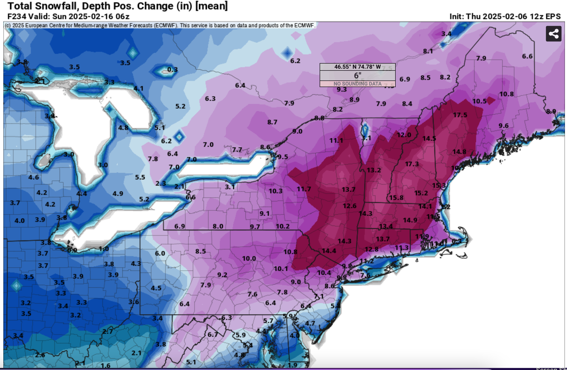
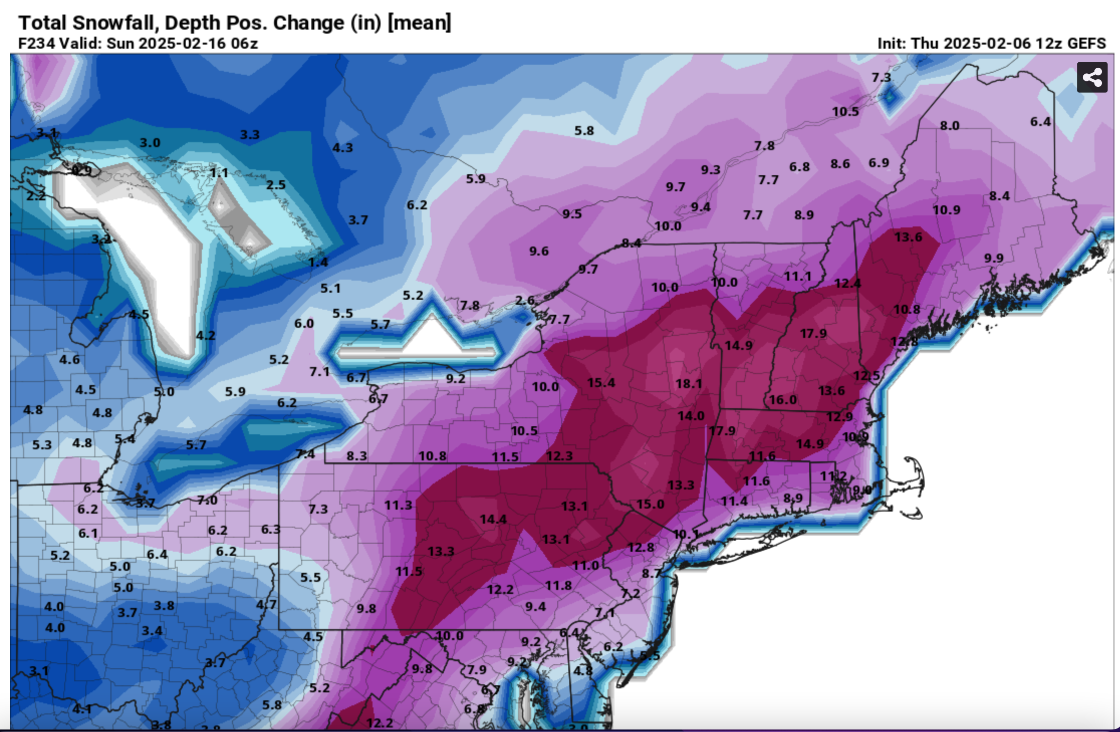
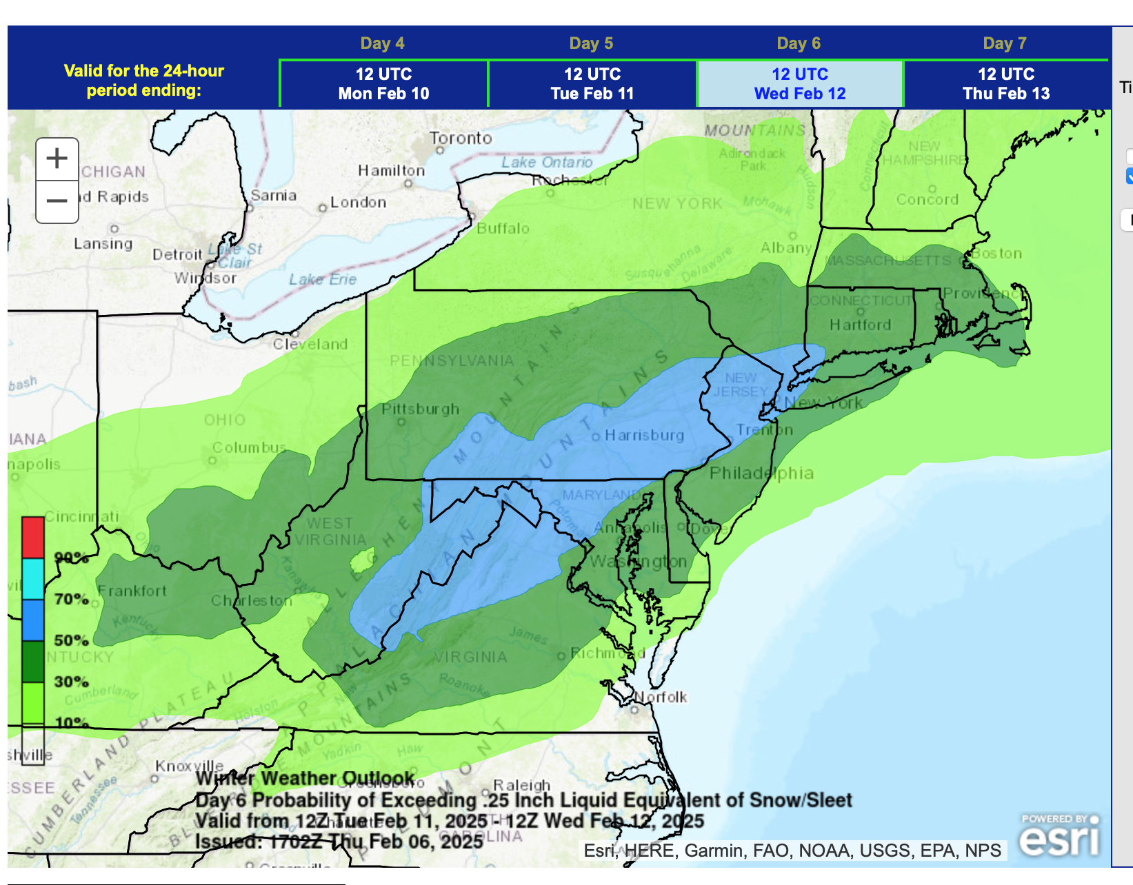
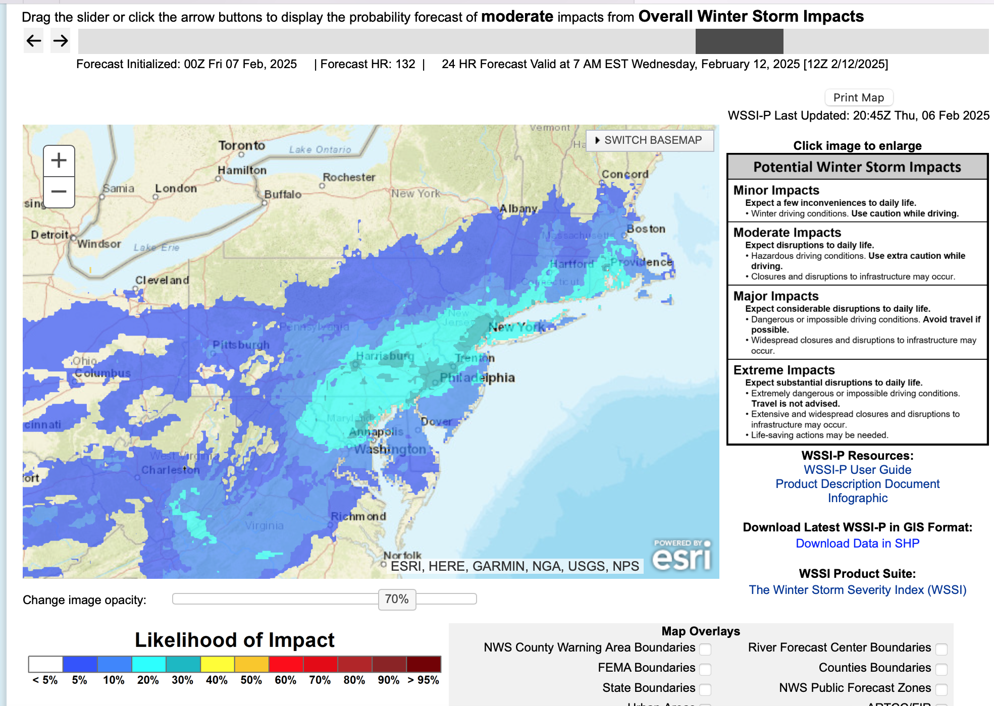
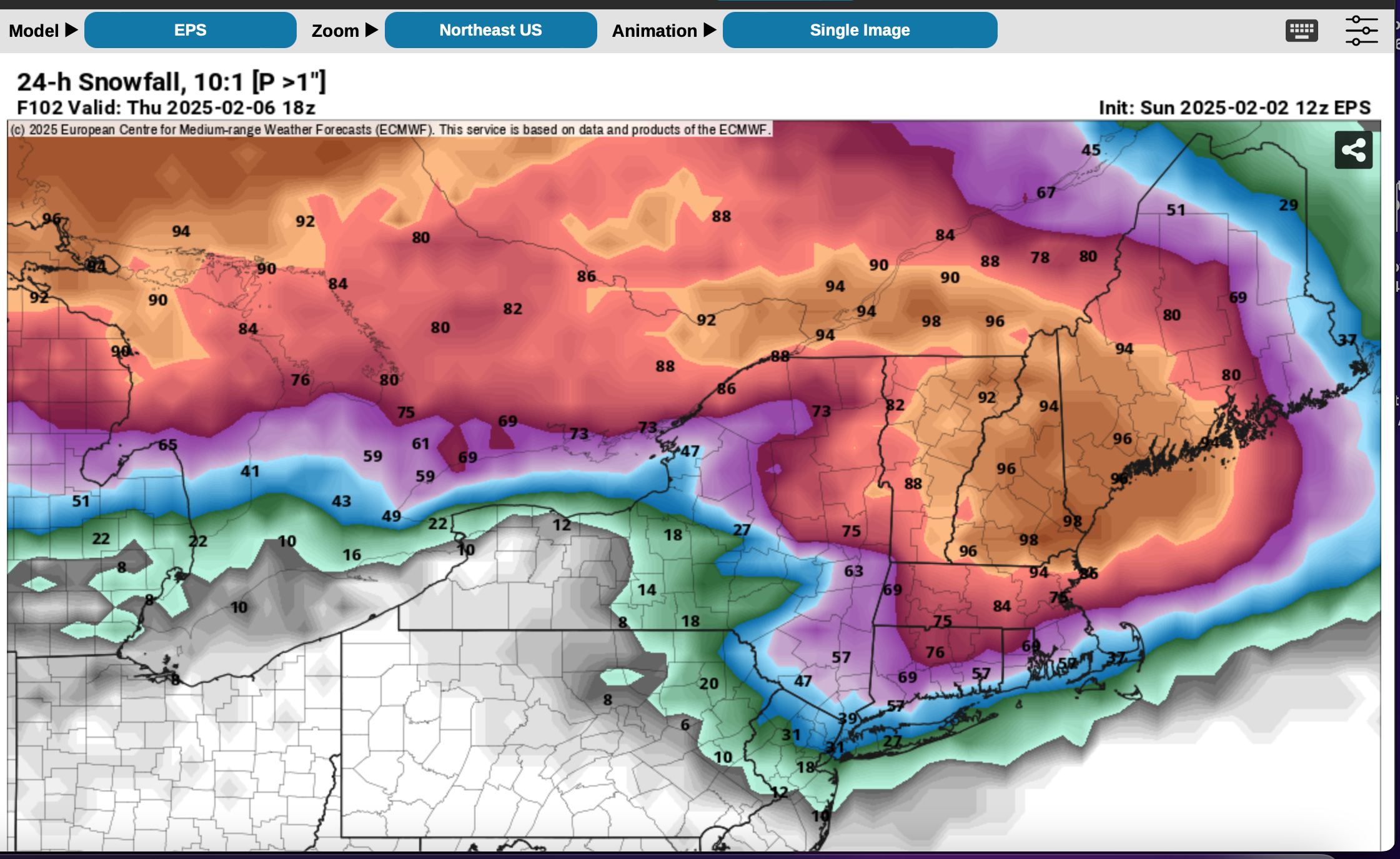
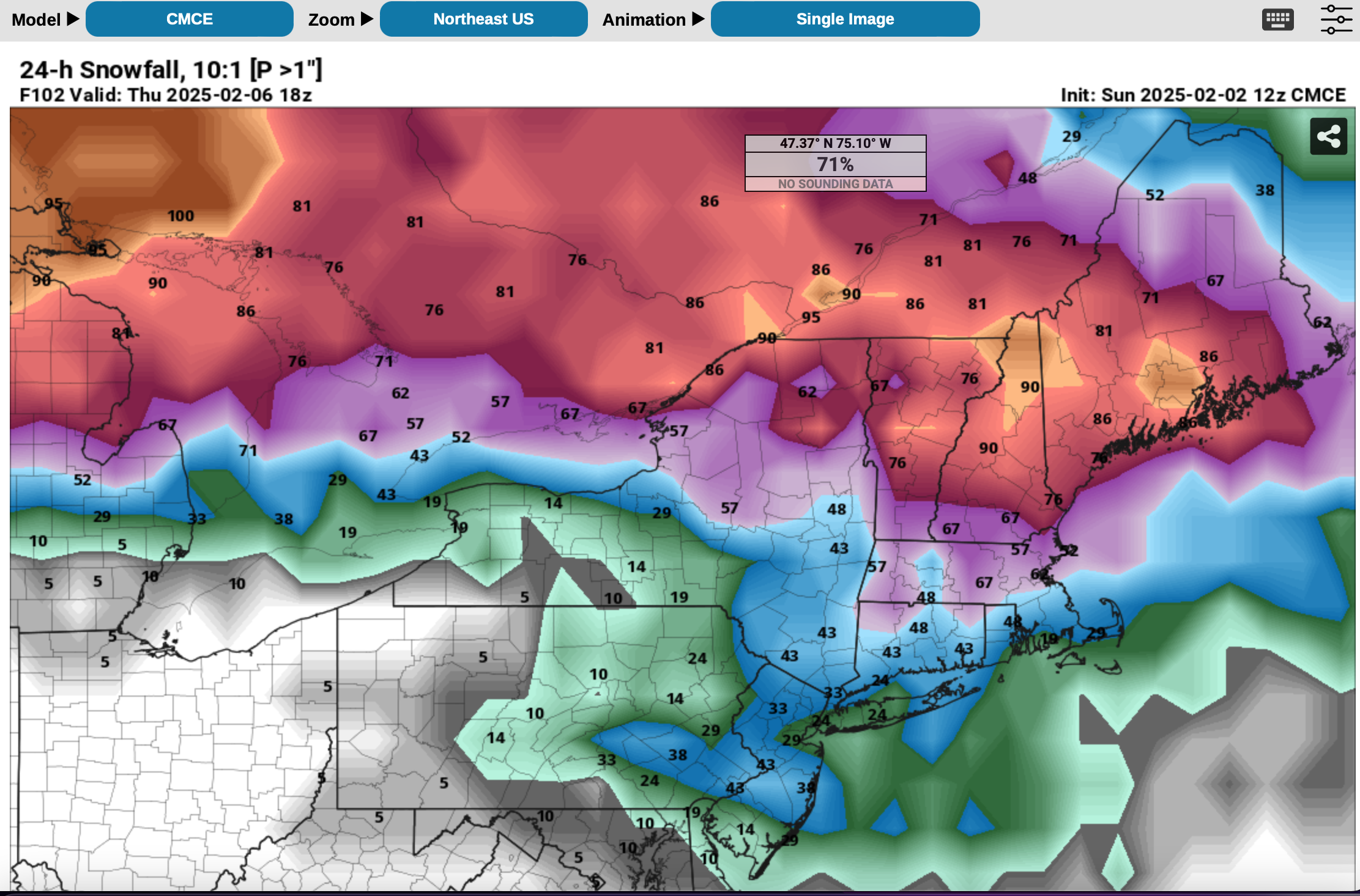
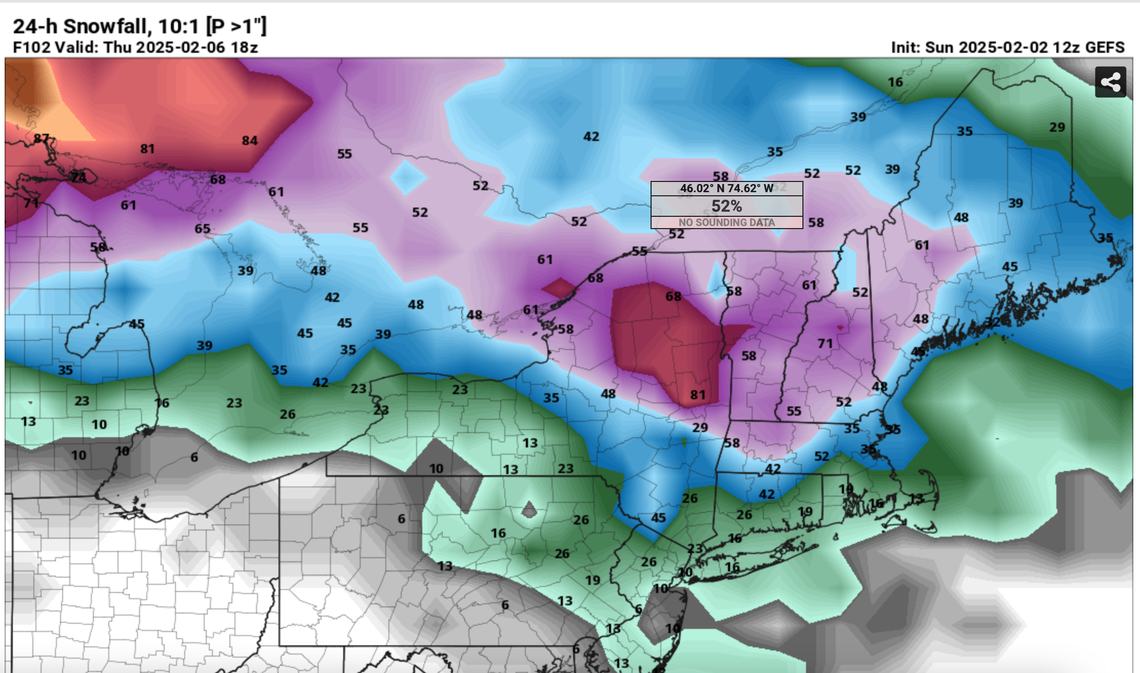
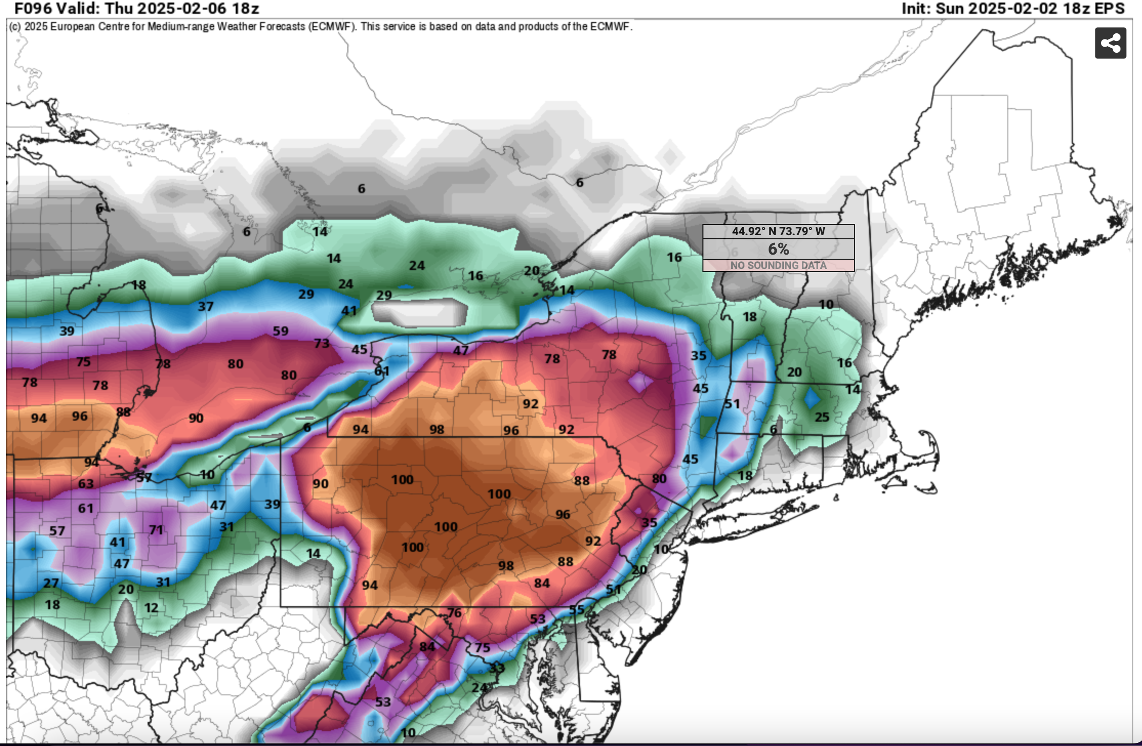
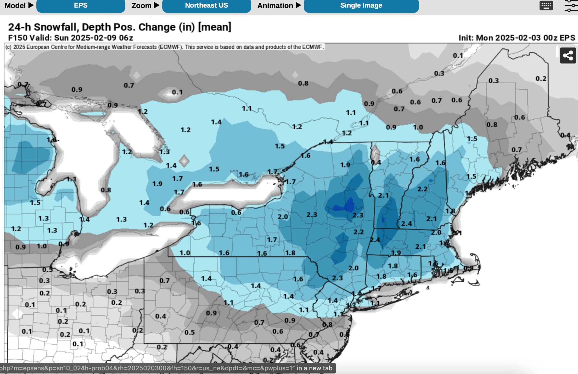
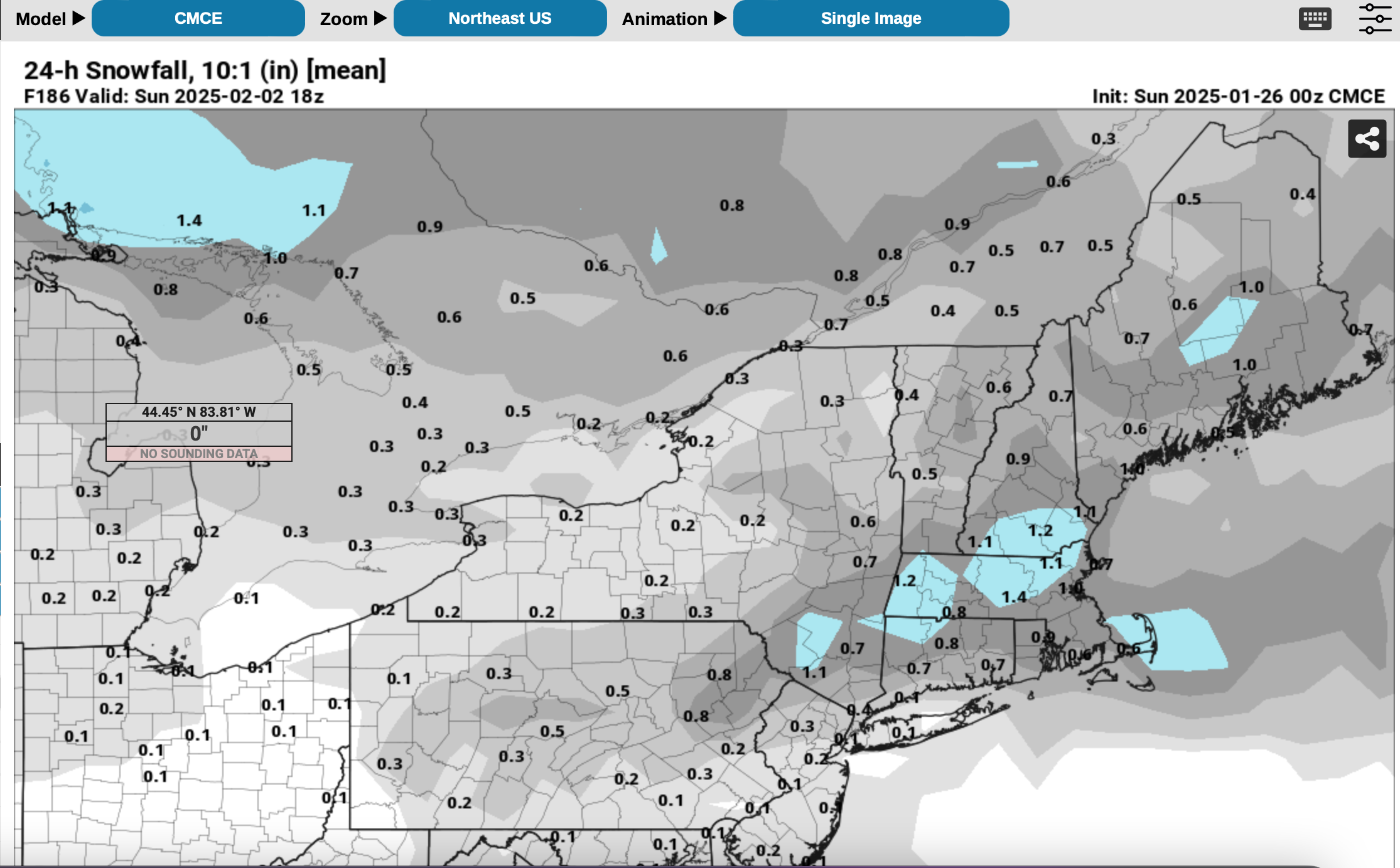
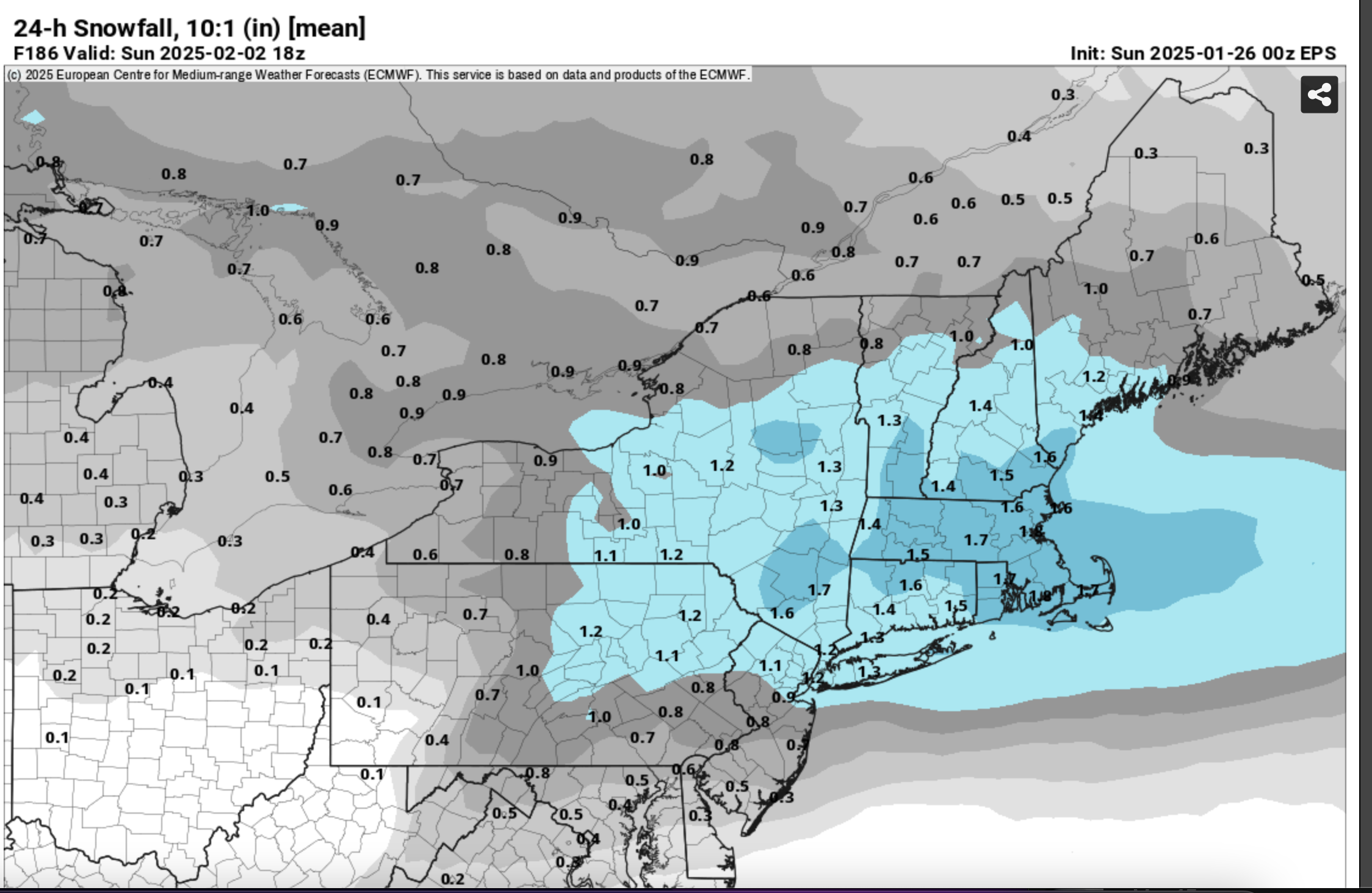
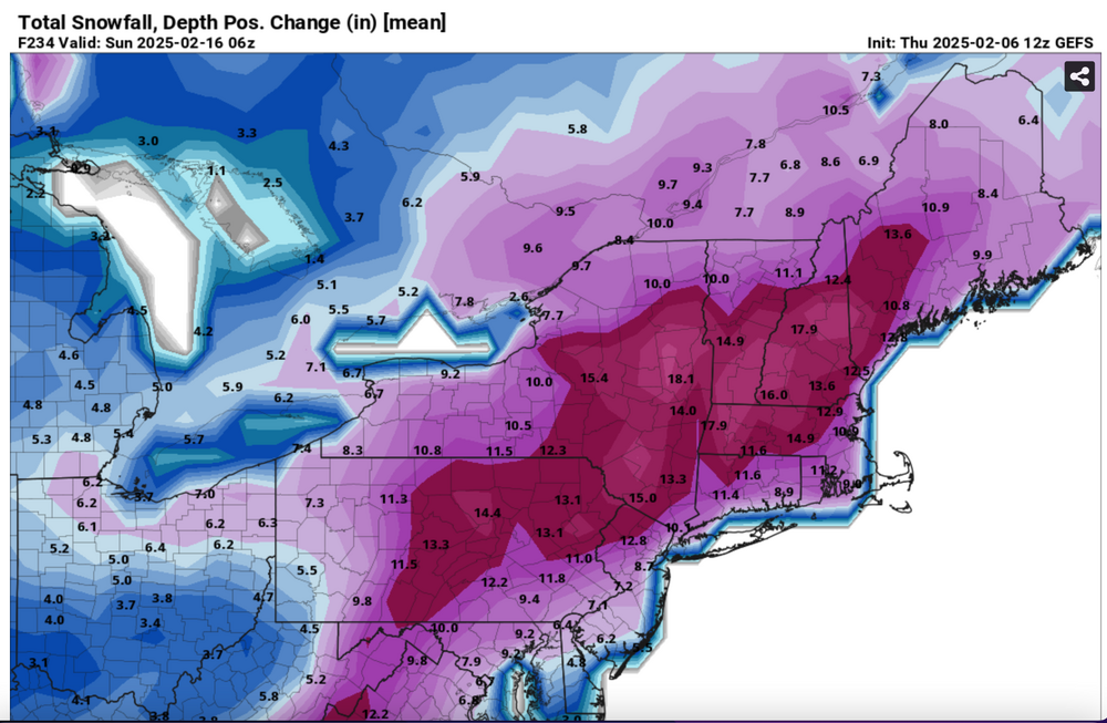
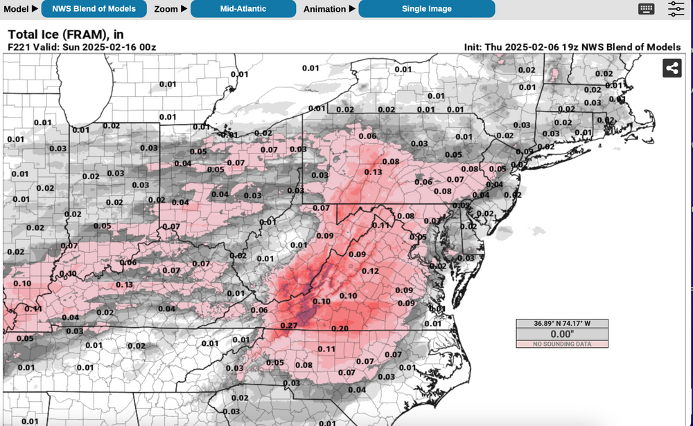
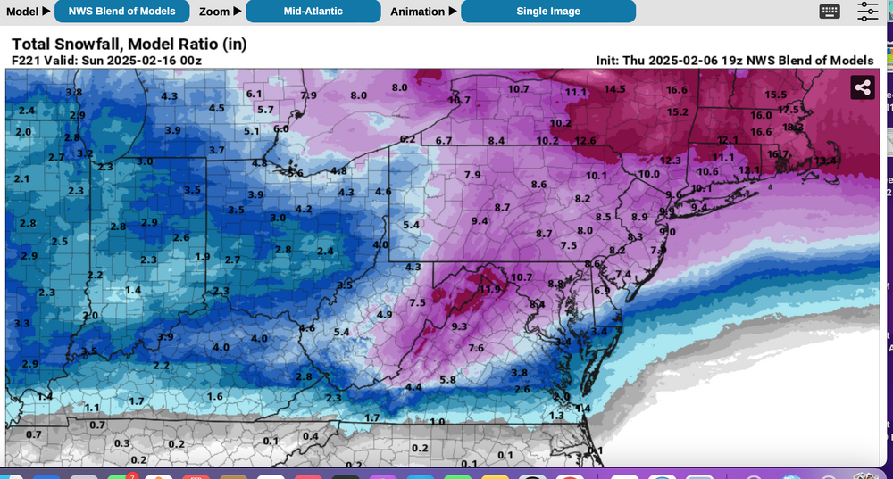
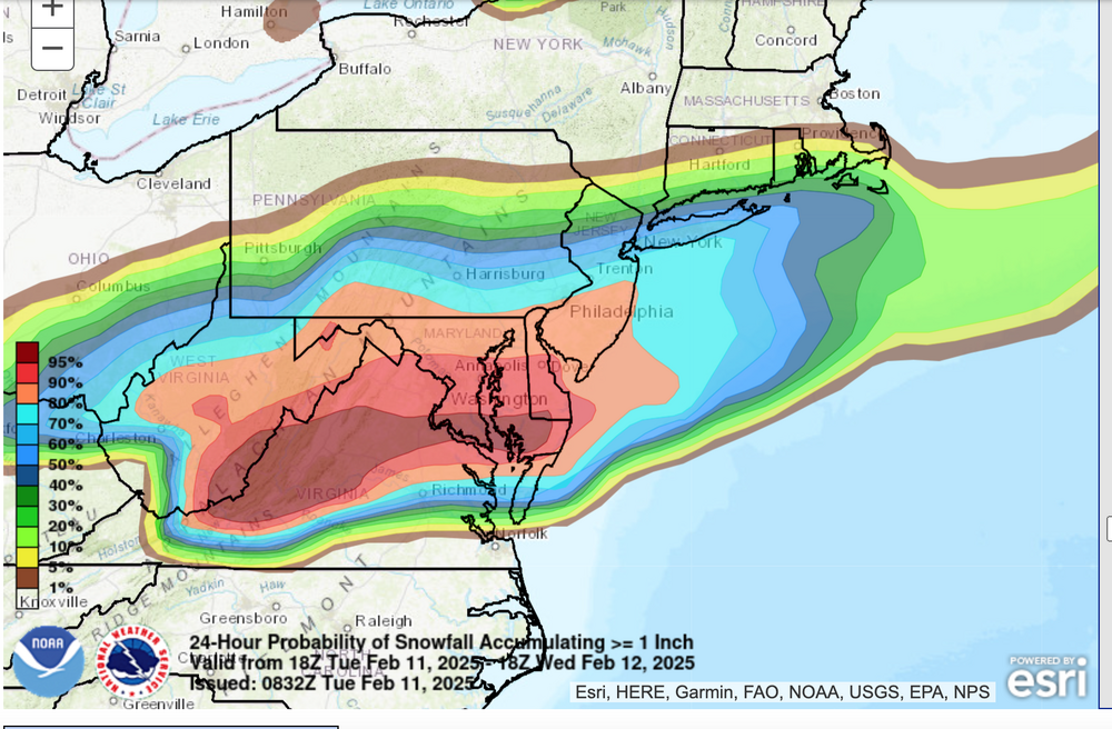
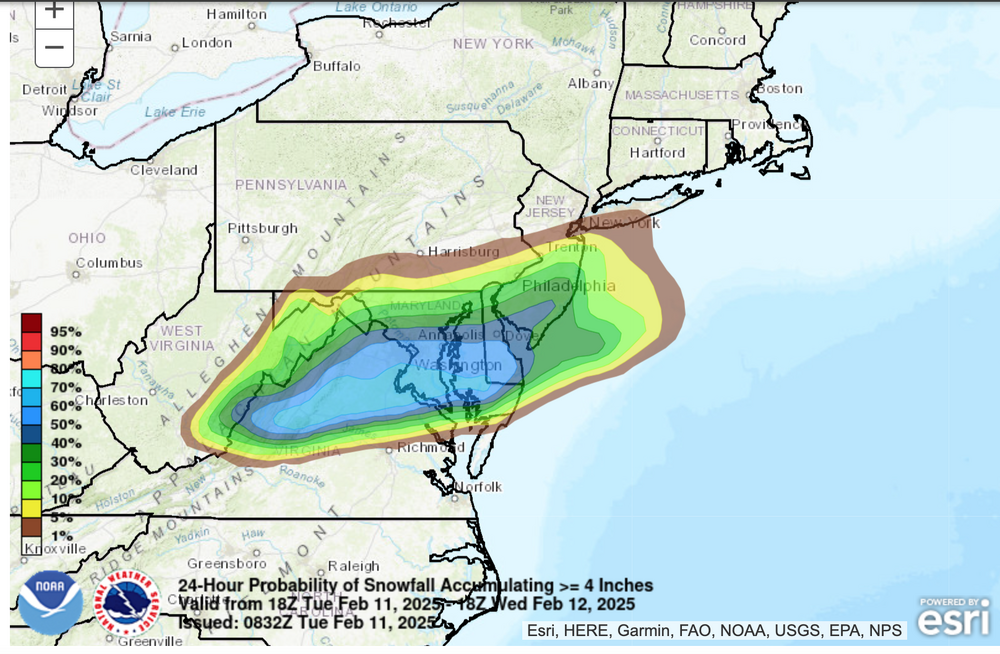
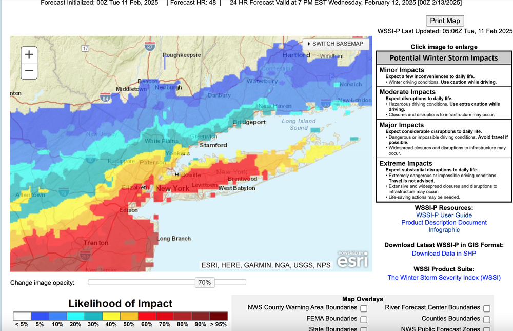
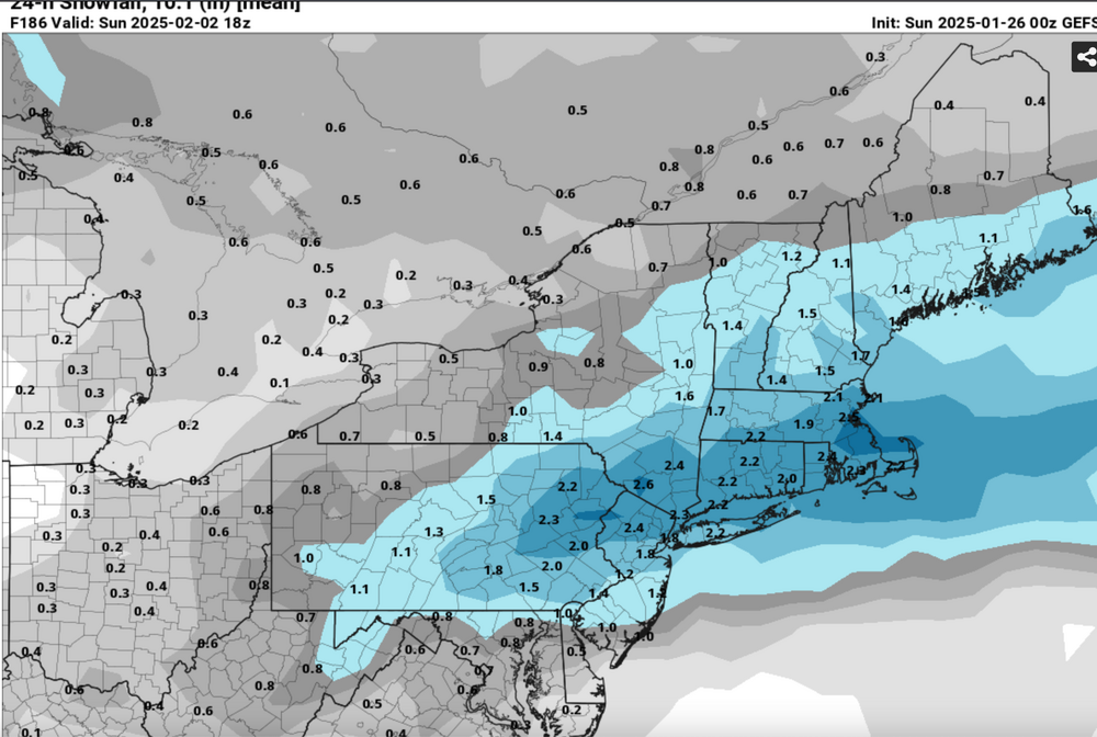
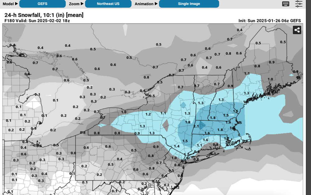
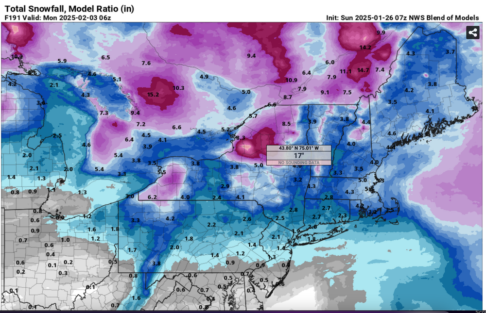
 Best chance for a total of 6+" inland with NYC-LI-coasts? Ensembles are added. All graphics should self identify. Ensemble snowfall is the more conservative positive snow depth change and prefer to minimize overhyping despite a decent looking pattern. It and the NWS Blend of Models snowfall does include some snow from this weekend, but the bulk is with in the Feb 11-15 period. One thing I dont like about the BOM is that it has averaged snowfall across all of LI instead of adjusted toward the ensembles. The BOM may be right if two of these decent events are all snow for LI. Included also is the Blend of Models somewhat realistic expectation of a little freezing rain, probably better than the EPS. The WPC 6-7 outlooks are attached and finally the conservative WSSI-P which implies an I95 modest snowstorm (low probs moderate in this example for D6) Generally cold high pressure should extend from the Canadian Rockies across southern Canada in this period with an average 150KT 200MB jet core persistently centered near Boston. That places the NYC subforum on the edge of the RRQ of the upper level jet, rather close to the core, so that in my opinion, some southward suppression might occur in the surface pattern during this time frame or the NAEFS (multi ensemble inclusive of the CMCE-GEFS) might change as the models change over the next week. Ensemble guidance basically is producing 1+" of qpf for our area in this time frame. All yours! 713P/6


-
Most of the snow tonight. Areas of light snow, flurries or possibly freezing drizzle may linger after sunrise Wednesday. NWS 08z/11 ensemble probs for 1 and 4" attached. At 734AM I added what I call the slippery factor--WSSI-P, run off 05z data... the red is 60% or greater chance of MINOR impacts overnight. I sort of like this product. Edited previously intended headline start time at 327P/11 At 410AM have extended the headline into the second event since this reduces thread bounce, AND, I think that "parts" of our NYC subforum including LI, NJ, PA will see an additional few tenths of an inch of snow today with ice pellet very minor amounts this evening, and of course the obligatory icing well inland overnight. Don't be surprised at a little drizzle-freezing drizzle for LI and the NJ coast today. The additional snow may not stick very well during the daylight hours as temps rise. Still suggest cleaning the snowboard AT MOST once every 6 hours and see what you get. I hope we get some decent rainfall overnight. Thank you for all your shares. I am considering starting the 19th-20th snow storm-event late this morning.
-
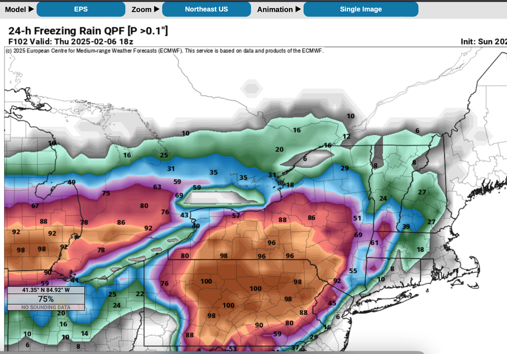
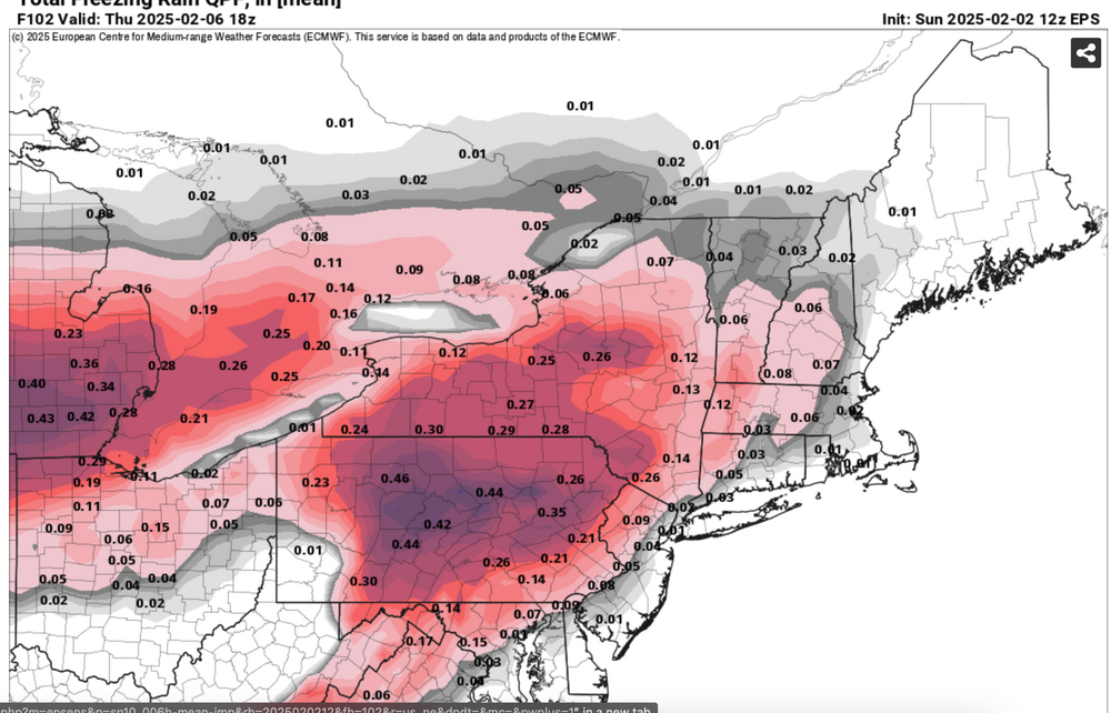
Discuss the possibilities of little more snow-sleet for NYC-LI. Please check back on the 7th for the review of the attached guidance, maybe used as a learning tool. Ensembles temporarily trended a little colder so that NYC CP-parts of LI may receive 1/2-1.5" of snow sleet to start before a change to rain. Most of the precipitation looks to occur 6PM Wed-Noon Thursday, starting as snow or sleet then changing to rain by sunrise Thursday NYC-LI, but freezing rain-sleet interior, northwest of I95. That freezing rain sleet may linger into midday over parts of nw NJ/interior se NYS, interior CT and the Poconos where mixing warmer air to the surface should be minimal until sometime Thursday night (baggy flow Thursday morning). Time of transition from snow-sleet to rain-ice will determine amounts of snow/sleet. This event may impact (slow travel-transportation delays) during the Wednesday evening commute depending on the start time, and "should" leave at least delays and/or widespread cancellations for the interior early Thursday. Total melted qpf should range between 0.3-0.8".. with the GEFS the least. QPF factors into the resultant amount of the various wintry elements. Ensembles already included are recently colder prob of >1" snowfall (includes sleet) from the EPS, CMCE, GEFS. the EPS 06z/6 2m temps, the ensemble chance of >0.10 freezing rain qpf from both the 12z and 18z cycles. Those probs have been consistently very high for the past several days---BUT caution on interpreting .10 qpf as .10 glaze. It could be significantly less depending on temp/rates of fall, drop size. I also added the EPS raw qpf interpreted as freezing rain. Ensembles show a primary low moving up into the eastern Great Lakes-upstate NY by dawn Thursday with a warm frontal wave moving northeast off the NJ coast, possibly maintaining itself through forenoon Thursday passing e of LI, then merging with the primary low in eastern Canada Thursday night and returning subfreezing temps to the area by daybreak Friday. The amount of subfreezing cold that returns in the wake of the departing eastern Canada low on Friday, will help determine what happens here next weekend (Feb 8-9). If somehow the primary near the eastern Great Lakes is dominant and there is no warm frontal wave of low pressure coming up the NJ coast, then snow-sleet amounts would be less. Final 757P/2. 702 PM Tue 2/4: headline delayed the start time about 12 hours to midnight Wed night. Bulk of the wintry mix probably occurs in a 6 hour window roughly 4AM-10AM. All of the NYC subforum and surrounding areas near and inland from I95 are covered by a winter wx advisory issued at 330PM Tuesday. Several hours of slippery conditions in snow ice are also expected in NYC and Long Island near dawn-sunrise Thursday before a change to rain. The delay was caused by the narrow snow streak in se PA-MD-DE Wednesday morning not advancing northeastward until Wednesday night.


-
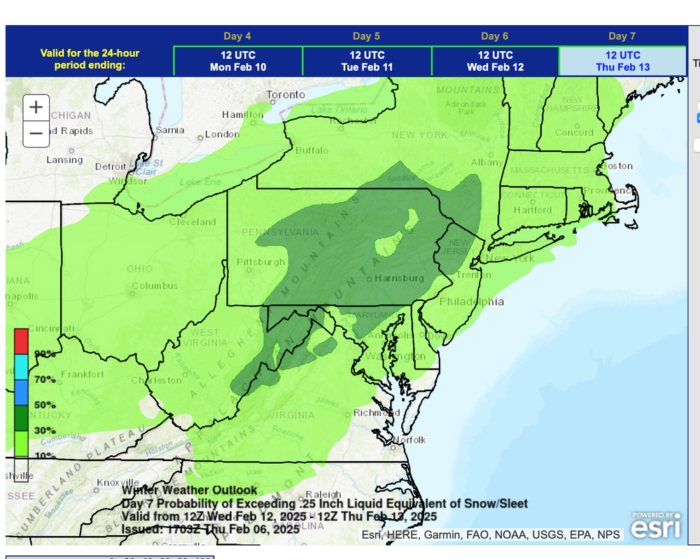
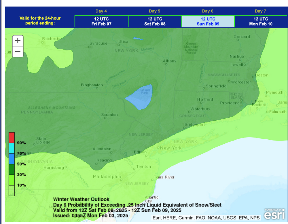
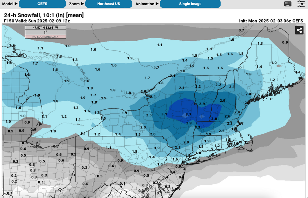
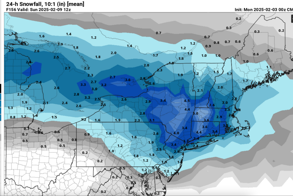
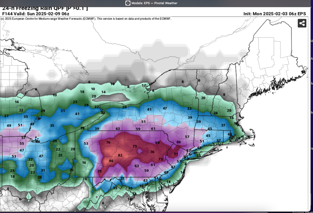
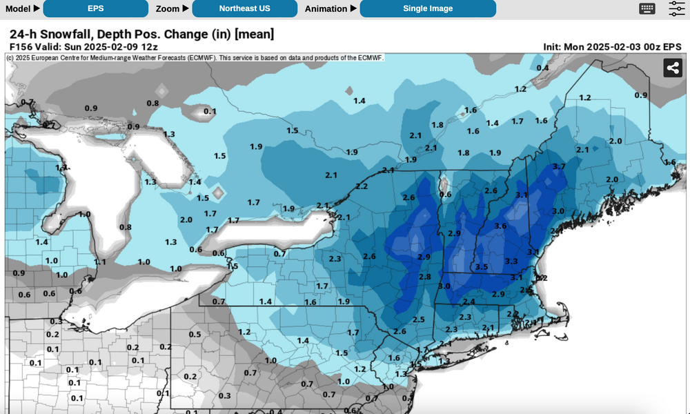
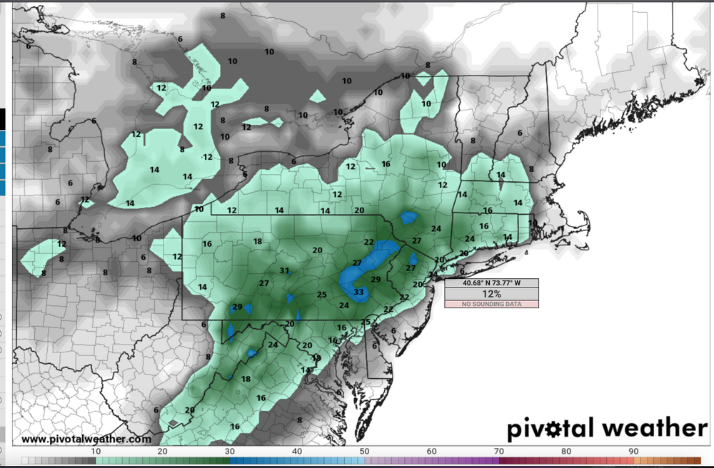
This coming weekend Feb 8-9 NORTHEAST USA near and west of I95 through the 184 corridor: Another mixed wintry event with delays and cancellations likely, especially later Saturday into Sunday morning. Timing might be in error as we're 5 days in advance. QPF is ensembled similarly to the 2/5-6 event, somewhere between 1/4-3/4". For now the attached ensembles favor I84 corridor down to the interior of I95 with more risk of rain and melting NYC-LI. The presented ensembles can be in significant max latitude (n/s) axis error 5-6 days in advance of the occurrence. It is a trackable event, in what looks like a train of events for February...some of which can veer off and disappoint but we're at least in the wintry mix game. Ensembles include the midnight 2/3 WPC D6 outlook confidence of >1/4" melted water equivalent snow sleet. (blue is greater than 50%, pretty good for D6. Other ensembles 24 hr snowfall (10 to 1 ratio), an ensemble that only shows positive snow depth change, and an ensemble probability of >0.10 qpf that is ice. This usually shrinks a bit as we draw closer to T0. 752A Mon 2/3/25

-
While most events are shaky on snowfall for LI due to thermal profiles, there should be a pool of subfreezing air covering the interior northeast during this event, available for making a messy winter storm, even down into NYC (NOT a KU). The remnants of this mornings CA 5H closed low will weaken as it heads eastward into the confluence zone over the mid and North Atlantic states this coming weekend. The cold boundary layer airmass that arrives Thursday the 30th after passage of an Alberta clipper off the Maine coast, should be available to interact with the Gulf moisture and lift generated moisture caused by the thickness overrunning ahead of the weakening upper low. Modeling is implying a secondary CFP Friday evening that will allow that BL cold in NYS-New England to be nearby. Precipitation type will be problematic due to the thermal profiles but the attached ensemble guidance suggests that this system is of trackable interest for our NYC subforum -both for travel into the interior where impact will be greater, and maybe witnessing some snow accumulation in NYC-though melting is anticipated on LI at times. Can our NYC 24-25 winter snowfall increase an inch or 2" next weekend (corrected my prior CP snowfall error). Ensembles should be self explanatory. I did add the EPS probability of >0.10 freezing rain Headline change below at 730AM Wed 1/29 for failed 7 day lead time on wintry accums NYC-LI. Discussion-OBS Jan 31-Feb 2 rain, potential minor interior impact mixed wintry events, mainly Fri Jan 31, Sun afternoon-eve Feb 2. Failed 7 day lead time LI winter impact. Events accelerated 18 hours and warmer-further north than modeling posted below in this thread indicated. Wrap up hat happened will post Monday Feb 3. P5 shows the NAEFS speed change. Self rated C-performance (see p 15 results against the ensembles posted here). Back end snow event entire subforum salvaged a terrible start. Max axis was significantly further north than ensembled. We had the Fri morning ice delays e PA/NJ/se NYS (24 hrs earlier than anticipated in this thread, but nothing else til the Sunday evening climatologically normal 1-3" snow event.


-
Attached is the NWS map for the winter weather advisory for icing tonight on untreated surfaces. Most of the icing should occur just northwest of I95 but spotty icing could occur even near NYC and on Long Island dependent on max temps this afternoon, and maybe a 2-3 hour window of radiating chill at sunset before clouds thicken and temps respond upward. Even if that occurs, wet bulbing and frozen ground could permit icing on rain contact with the frozen ground just a few miles away from NYC.. Canadian modeling and the SPC HREF have been leading the way as well as the HRRR. The ECMWF and GFS global models have been largely devoid of ice tonight. I've also added NWS probabilistic chance of .01 freezing rain and .10 (brown 5% chance).
-
 We may get the sequel to the current event Thursday and Friday through the weekend. The ICON came more on board with the GFS tonight. The Canadian is trying a bit itself. We aren't likely to get nearly as much snow as we did with this system, but some of us may get more. People rarely like the sequel better, after all. But maybe for our mix/rain victims, this one will be better. The original is going to be hard to beat for most of us.
- 372 replies
-
- 11
-

-

-
- cold
- arctic blast
- (and 1 more)
-
Most of our long range looks are well into December now. Hopefully we can have a better winter than last year, which was an all-time worst here. The first week of the month looks to be near normal temp wise and probably drier than normal, even though CPC favors AN precip.
-
 We will soon find out if the high latitude blocking signatures pay dividends for our area. May need a boat and may also need snow shovels. We'll try separating this into threads by month. If that doesn't work, I will simply switch this to Part I of winter. Have fun and good luck!
- 582 replies
-
- 6
-
-
-
- snow
- freezing rain
- (and 4 more)
-
It's becoming more and more likely that at the minimum, western forum area members see a dangerous ice event as the week unfolds. The modeling is currently trending towards heavy ice accumulation for West Tennessee, moderate to heavy for the mid-State and Kentucky, and light to moderate over the Plateau areas. These ice amounts would be devastating for trees and the power grid. West Tennessee is actually one of the most freezing rain prone areas in the United States and these massive ice storms happen there.
- 99 replies
-
- 1
-
-
- ice
- freezing rain
- (and 1 more)
-
While uncertainty exists on the target for a rain to hazardous brief commuter significant snow event, a thread has been started to take the load off January. Thursday morning I84-NYC-PHL: Looks like 1-3" of snow in a 6 hour period centered on sunrise, with potential significant impact to morning travel due to temps falling to freezing during snowfall. There is model uncertainty on amounts. Snow could fall for an hour at 1/2-1". I84 itself seems to be on the northern fringe where snowfall could be less than 1". Amounts also depend on how fast the preceding predawn rain showers change to snow but I am confident of a snow event, just not confident who gets the biggest impact. Tomorrow morning we should have a much better idea of travel impact. I would add that climo on something like this probably favors an inch or less NYC CP, but I do think there is going to be a narrow lane of more than 1" per multiple model indications. NWS ensemble risk of greater than 1" is less than 30%, so that is the reasoning for calling this Potential, in the headline. 656PM: adjusted Title to OBS-NOWCAST. Added freezing rain and rain to the tags. First batch of mixed precip should arrive ne PA, extreme nw NJ and se NYS around 1-2A as snow freezing rain-rain, but the primary batch is slated to occur between 5AM and Noon as snow north and west of NYC til NYC-Li and NJ I95 changes to snow around 7-830A. It ends from northwest to southeast, first in nw NJ by 11A and then NYC by 1P and further southeast during mid afternoon. Amounts near I84 of a dusting to possibly 2" with a general 1.5-4" in the core of the event from near NYC/LI-down I95 in NJ. It may briefly snow 1/2mi moderate for an hour or so. Still a little uncertain where the 4 inches are...probably NJ/LI.
- 280 replies
-
- 4
-
-
-
- snow
- freezing rain
- (and 1 more)
-
Please follow National Weather Service warnings/statements. Starting from another 10 degree morning in NYC, a rapidly changing weather scenario will cause some power outages, accidents (despite a Holiday weekend) and slippery travel for a time in a fairly large portion of the forum, in part due to at least 42 consecutive hours of freezing temperatures on non snow covered ground, and beginning near sundown when the impact of solar insolation lessens. Exactly who gets how much of what is being determined by member observations with model and forecast contributions enhancing, but not hyping interest. Coastal flood threat as per OKX. Usually we like at least 12 hours of gale force onshore flow to build the water levels, but with the astronomically higher tide cycle, 980s MB pressure at Monday morning high tide, an inch of rain in the 6 hours up to high tide emptying from rivers-streams, there should be enough surge and incoming wave action to cause coastal flooding. Working a bit against the flooding NYC southward along the NJ shore is the onslaught of wind abating and turning southerly near the time of high tide. Certainly the early part of the morning high tide cycle looms larger. If you're in a tidal inundation area, follow NWS statements. I'd park my car with parking laws in mind where it can't get flooded. Wind damage: several 12z/16 HRRRX graphics are appended. Please use the legend. Midnight to 6AM is best chance for damaging wind , to occur in a 3hour period ranging from near 2A NYC to near 5A e LI. Gusts to 60 kt possible e LI with gusts 45 kt possible NYC metro airports. I could be too conservative. Have cell phones charged and be prepared for no internet early Monday. Many of our members, even to western LI will be reporting a bit of snow or sleet late today (some are from Ocean Effect already). mPing will be helpful especially for us inland folks just north of I78 where an hour or 2 error in the precip phase change from snow to sleet/freezing rain or rain can mean an inch or two of snow. The 12z HRRR, HRRRX, and 3K NAM seem to support slightly more snow than maybe some are anticipating. Whether that occurs is unknown. No matter, if you have heart problems and live north of I80, you may want some assistance removing slush laden with maybe 3/4" of rain (glop). And of course have your resources to clear it by 6PM Monday when temperatures falling below freezing start the solidifying process. {The HRRRX amounts may be too large by 2", so it is a slower to change model with 1/4-1/2" everywhere up through I84 by 06z, so that could bias the amounts high there. edited in at 1036AM} ICE: I think parts of the I84 corridor including Sussex County NJ may have pockets of damaging ice near 4AM Monday when the ice combined with wind gusts 45 MPH in the ridges could be enough to knock out some power. Monday afternoon-evening: The trough aloft passage and influx of colder air should wring out areas of 0.1-1" snowfall in the steep moist lapse rates associated with the cold pool aloft, including NYC-LI.
-
Have added the 5AM January 7 NWS ensemble probability of .01 freezing rain Sunday. These probabilities are quite high for a day 3 forecast. Not talking damaging to trees and wires but with the fresh snow cover, frozen ground and modeled dew points not exceeding 32F Sunday, ice looks highly probable, even to NYC-LI. Depends on timing. IF the precipitation doesn't arrive til 11AM or after in NYC (I95 to the coast) then treated pavements will be okay. Winds at the surface will probably be light southerly-southwest. This should ensure the LI coast to easily warm above freezing in the afternoon, if not during late morning. RGEM and NWS ensemble is the basis of this thread. The GFS still doesn't handle boundary layer temps very well. The EC looks better than the GFS but it too doesn't appear as threatening as the Canadian and SREF (oh no-the SREF?). Also: while the primary thread time frame is Sunday morning, it's possible periods of freezing rain can linger into mid afternoon along the I84 corridor hills which includes nw NJ/se NYS northern CT. Have even seen modeling turn this to a short period of light snow north of I84 but am not convinced.
-
Showers are moving northward into our area and with frozen ground and subfreezing conditions, it could become quite slippery on untreated surfaces in some spots along the I95 corridor just southwest to north of NYC. The National Weather Service has advisories posted. Added NYC 550AM as well per obs below. Also some snow mixed at the start nw NJ thru se NYs, W CT, WMA.
-
Overall assessment as modeling monitored through 6AM Monday. Complex intermittent snow to sleet to freezing rain scenario with potential for 0.1"-0.5" measurable snow sleet NYC-LI while parts of the I84 corridor receive spotty 1 to possibly 2" snowfall. It should begin in NYC/NJ/ne PA/se NYS between 11A-2P and CT maybe between 2-5P. While treated surfaces in metro NYC should be mostly wet, caution is advised everywhere. The National Weather Service has advisories posted for the I84 corridor. I think this could be more of a problem further south in NJ. Also: the worst of this for some of our area could occur near sunrise Tuesday if it clears after midnight and everything refreezes into a frosty icy mess, especially driveways, sidewalks-steps. No thread expected (at least not yet) for late Tuesday-early Wednesday where w wintry hazardous mess is expected again-at least for the high terrain of I84 (strong mid level Frontogenesis). A few graphics to give an idea of what should occur. 631A/27
-
515A/19: Intermittent event continues and precip intensification gradually changes freezing rain/freezing drizzle sleet near I95 eastward to snow. Ending time still the same, this afternoon sometime ne PA/nw NJ/se NYS and the remainder sometime this evening-early tonight. Between 7AM-ending time, I expect a general base 1/2" new throughout the forum after 7am with possibly as much as 3" , the heaviest seeming to be near NYC into CT per a decent band developing this morning-midday, and possibly a nice hour of closing snow this evening. Easy melting process on pavement expected during the midday-afternoon hours where temps above 25F and when snow lessens it's intensity. Manageable but fun for us. 450AM/18: overall no change in expectations. Might get started an hour or so slower but already flurries or steady light snow have occurred se NYS, ne PA, CT, far nw NJ. See latest NWS products and your own judgement. 548AM added the 4AM NWS regional snowfall expectation that went into their early morning products. An overall manageable 24-36 hour wintry precipitation episode will probably see snow change to a mixed bag in NJ/LI, with even a bit of rain possible for a time eastern LI and the NJ coast. Snow should begin in seNYS/NJ/NYC between 2AM and 7AM Thursday and by 9AM elsewhere. It should snow moderately for a time sometime between 9AM and 4PM Thursday before probably transitioning to mixed precipitation or even quitting for a time in NJ/LI toward Thursday evening. Precipitation may intensify again as it probably changes back to snow everywhere on Friday and then gradually ends from west to east during the afternoon, or early Friday night. Graphics are the 21z/17 NWS ensemble 48 hour prob for 8"+ of snow, 4"+, the 12z/17 SPC HREF snowfall ending 00z/19 = 7PM Thursday, the 5PM/17 actual NWS regional deterministic (approximate) snowfall forecast and the 21z/17 WPC ensemble prob of .01" freezing rain. Thursday afternoon into Friday morning. Please contribute as needed.
-
Here we go again. Winter storm watches up for some areas already. RAH starting to sound the alarm on this morning’s discussion. Hoping those who got hit last weekend somehow avoid another major ice event but the modeling is painting an icy picture at this point
-
OBS and nowcast Monday Feb 15 - Noon Tuesday Feb 16 2021
wdrag posted a topic in New York City Metro
610A updated thread....my last topic update and all my other posts will be in the observed below. Adding several graphics from the 4AM NWS forecast process inclusive of the ICE STORM WARNING coverage area (purple), the HPC HREF ensemble 1/2" of glaze expectation by 7A Tuesday (blue), WPC ensemble probs of .10 glaze (orange) by 7A Tuesday and the much lower prob of 1/2" glaze. I would expect power outages in the NWS warning area and SPC HREF Blue coverage area. IF these amounts work out- I think it will be big. Modeling doesn't necessarily guarantee freezing longer than 4AM Tuesday, so if it's not, then the rain is non freezing its heaviest 3 hour period. Still the ground is cold so I'd plan on a bad night, and in fact a bad day today in the I84 corridor on all untreated surfaces. Regarding info near NYC... just be careful. Untreated's slippery near NYC-LI today-this evening, should ease sometime tonight. Looking at 06z/15 NAM FOUS...if that surface wind stays ne in NYC through tonight as the sfc low transits coastal NJ, the guidance will be too warm at the surface. This needs careful monitoring. My guess, via the 06z/15 guidance, there may be an underplaying of extensive ice damage, especially just west of the 4AM warning. Just a degree or two makes a huge difference. I'm not expert enough to know for sure. So for me here in Wantage NJ, if its still 31-32F at 4A Tuesday, we've got pretty big problems in far nw NJ/se NYS/nePA. We will see how the probs work. Prep worst and hope for the best. While a bit of snow is possible Monday along the northern edge of the subforum, most of this event should be freezing rain or rain with heaviest amounts Monday night. Sleet may occur as well for a time Monday. If freezing rain lasts long enough in the warning area of the forum, and accretes thick enough, tree damage and power outages would occur. Spotty poor drainage street flooding is possible in NJ, LI. 21z/14 NWS ensemble high probs for freezing rain and low probs for 1/2" glaze are posted. -
A seemingly - relatively boring advisory light mixed wintry elements event seems to start as snow or sleet near I-195 in central NJ this morning and spreads north to the I78 corridor and LI by mid or late afternoon, eventually changing to a bit of freezing rain tonight. It ends sometime Sunday, probably midday ish. Have ended the topic time as Noon Sunday, since thereafter, temps probably close to or just above freezing with any remaining icing negligible for the remaining daylight hours. The region north of I80 in ne PA/nw NJ/extreme se NYS and s CT should see a period or two of light snow/sleet this evening into Sunday morning but the precip is so light that dry air may evaporate precip with nothing reaching the ground near I-84 in the northern part of our subforum. Uncertainty on precip types and even amounts, but thinking a few tenths of an inch of sleet here and there and certainly slippery at times all untreated surfaces this Saturday evening, Noting any spotty icing near dawn on the 15th as sporadically modeled near NYC is not covered in this thread. Advisories are posted for LI and much of NJ. Please follow NWS advisories and statements on this light prelim event for what appears to be daily bouts of wintry elements in portions of the forum the 15th, 16th, 18th and maybe early 19th. Leaving this last sentence as a place holder for updating the other the other threads by 930AM and deleting at that time once those are updated. Added WPC probabilistic ensemble graphics for today and tomorrow to assist with confidence but are necessarily imperfect due to the proximity of the ocean.
-
528A update: OKX snow forecast remains the same this morning. Small chance NYC record 1/2" of snow...southern part of LI should have less snow than than the north. Otherwise forecast looks fairly close from yesterday. Not sure if nw NJ can exceed 3"? I think best chance spotty max 5-6" is I84 or northward, high terrain Catskills to northern CT high terrain. Take whatever we can get. Hope NYC can muster some measurable snow early this morning around sunrise or shortly after. Snow begins 2A-5A west of the Hudson River to the Poconos and Catskills; then thereafter across CT by 730AM. NYC snow at daybreak may accumulate 1/2-1" before quitting and/or changing to rain midday then may end briefly as snow toward sunset. The snow over nw NJ through se NYS and CT may accumulate as much as 6 inches in a few high terrain spots but most of the snow fall should be in the range of 3-5" there. South of I-78 in NJ, to I-I95 a period of snow tomorrow morning may change to freezing rain or rain before tapering off in the afternoon with Trace to 2" accumulations. Untreated roads along and south of I-80 and LI may be briefly slushy in the morning before melting begins. Hilly area untreated secondary roads to the nw to n and ne of NYC will be a bit slippery at times. Snow, especially during the morning commute could result in some accidents and travel delays, especially hill towns. There might be a few school districts in the hilly areas with in-person classes that may close at the last minute, especially se NYS and far nw NJ. Graphics are the OKX snow forecast and the chance of greater than 1" as issued at 330PM.
-
A challenging period of travel is possible Friday morning across northwest NJ, northeast PA and se NYS; possibly into the CT portion of our forum as multiple bands of precip sweep eastward across the region. Amounts will be light but where possibly freezing rain or sleet, untreated surfaces could be quite slippery. Additionally there will be a tendency for any rain/freezing rain to briefly change to steady snow even to just west and north of NYC with little or no accumulation there, while high terrain in nw NJ/ne PA/se NYS and w CT are modeled to pick up 1/2-2" before melting begins ~ 11 AM or Noon. mPing. This thread will help concentrate interest Friday mornings system while the other threads occupy the Sunday event and beyond.
- 21 replies
-
- 2
-
-
- snow
- freezing rain
- (and 2 more)
-
mPing should be interesting. The advisory for a mix of wintry elements will probably start with a burst of decent snowfall rates between sunrise and 2PM before a probable change to rain, freezing rain or sleet on LI and I80 southward during the afternoon and possibly back to ice or snow early Wednesday. The i84 corridor should be mostly snow, if not all snow. The region southeast of I95 in NJ after starting as snow or sleet should transition to plain rain by Tuesday night but it might be marginal for icing in Monmouth-Middlesex counties near the colder air sitting astride I80-LI. This I believe is the first expected widespread winter weather advisory event dating back to at least January 3. There's a small chance for a period of flurries along I195 to maybe near I78 in NJ between midnight and 4am but the main event in the NYC forum begins during the daylight hours Tuesday.
-
We don't get them of significant intensity in our area (thank goodness!) but it's possible and has happened. The 1998 storm that hit Canada is probably the worst in somewhat recent times. I remember seeing pictures and videos on the news. I also worked with families that were in the middle of this and it was a life threatening and changing event they will never forget. RE: So naturally when talk of significant icing (> .25") comes up, I always think of those storms. Especially at night, the flashes, the humming, cracking branches, et al. This is probably the closest to what we experienced on Feb 04, 2014 here: And amazingly, our power never went completely out for significant time during that event! Lots of booms, humming, flashing. A friend of mine was out for 12 days due to that and it took 1 1/2 days to clear out the trees on his lane so he could get out! Anyone here have stories to share? Please do!
-
- 1
-
-
- ice storm
- freezing rain
- (and 2 more)
-
A routine wintry ice event, that will create some travel problems in high terrain above 1000 feet late today and early tonight, primarily along the I84 corridor.