Search the Community
Showing results for tags 'Snowstorm'.
-
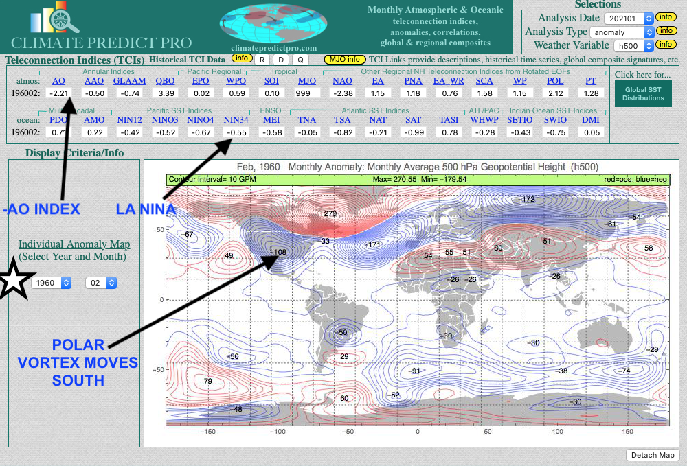
As a lover of weather, you owe it to yourself to invest in other things, other than gamestock One way to get your feet weight using your love of weather is by trading commodity ETF's such as natural gas. They can be traded at your brokerage firm like Fidelity, etc. For example, since I started telling clients 2 weeks ago about the Polar Vortex, natural gas prices have rallied some 13% in two days; that's not bad considering keeping your money in cash or a money market makes less than 1/2 of 1% Another major snowstorm is coming to the eastern U.S. this weekend and due to the negative Arctic Oscillation Index. This report here talks a bit more about that and why February and potentially March will be cold https://www.bestweatherinc.com/commodities/how-we-predicted-the-arctic-pig-for-february-setting-the-energy-markets-on-fire/
- 4 replies
-
- 1
-

-
- natural gas
- heating oil
-
(and 2 more)
Tagged with:
-
"Blizzard of 2018" Snow fall map final one
USCAPEWEATHERAF posted a blog entry in Once a legend always a legend
I added lollis of 24"+ to the map because I seriously think the storm hits the benchmark and pushes the snowfall further west, Hartford, CT to Boston, MA gets 12-24" of snow overall with less on the Cape and Nantucket due to more rain forecasted, this storm came west congrats people along and west of I95 corridor -

Snow this Weekend, Epic Blizzard, or coastal fail?
USCAPEWEATHERAF posted a blog entry in Once a legend always a legend
Today all options remain on the proverbial table. Anything from an epic blizzard to a weak coastal is in store for this weekend. NWS Taunton has a 1in10 chance snow map for 4" in my neighborhood, and a 1% chance at seeing 8"+ this weekend. Let's discuss this major potential? -
00z models show some moving southeastward with the snow threat this weekend and the GFS and CMC bring a coastal nor'easter threat and clipper threat to the Northeast next week, I will have an update after I wake up in the morning and then again after the 12z runs.
-

**12z Model Update for storm this weekend**
USCAPEWEATHERAF posted a blog entry in Once a legend always a legend
Most of the afternoon and late morning model guidance has trended towards a much larger and more severe event with the exception being the GFS, while the GFS produces over 8" of snow for the Cape, it also is weaker with the storm for Saturday. We are less than 72 hours away from the first impacts of this winter storm, mix with rain is possible on the MA coastline, including the islands of Nantucket and Martha's Vineyard. Winter storm watches could be issued as soon as Thursday afternoon from Taunton and as early as tonight for the Deep Southern states of LA, TX, GA, FL, and NC and SC. This storm reminds me of the 2004 Boxing Day Snowstorm, December 26-27th 2004 -
March 11th 2017 605pm entry: Very cold air mass overhead the Northeastern US tonight. temperatures for Sunday morning lows are around 10-12F over the Cape. Forecasted temperatures won't break 25 the next two days Sunday and Monday. This arctic air mass will be the reason we can expect a snowstorm to occur some time Monday night through Wednesday morning depending upon if the storm slows down at all, right now the 12z and 18z runs today show a progressive but easterly track with less phasing, although I don't think this is about a less of a phase. While common knowledge dictates that the stronger the phase the further west the storm tracks is correct most of the time, the 18z GFS and NAM are both east of the 12z runs positions, and therefore show a faster transfer of energy between the clipper (primary) low and the coastal storm that takes over earlier on the latest guidance. Given nature of the H5 trough, this should allow the coastal storm to intensify rapidly and be in the lower 970mb range, rather than the higher 988mb range the GFS has. Therefore winds should gust between 70-90mph, 70mph if the GFS is right or 90mph if the stronger solutions are correct. Remember the faster the transfer of energy between the primary OH Valley low and the coastal low off the coast of SC occurs, then the further eastward it will travel, I don't expect a far east track, but one down the middle of today's guidance, over the benchmark, east of ACK and CHH of around 970-980mb low pressure center producing a few feet of snow from DC to BOS with NYC to BOS receiving the mega amount of snowfall of around 24-30" of snow. Coastal New England including Cape Cod should remain all snow and receive up to 34" of snow. Those are my thoughts right now, subject to change.


