TellicoWx
-
Posts
2,283 -
Joined
-
Last visited
Content Type
Profiles
Blogs
Forums
American Weather
Media Demo
Store
Gallery
Everything posted by TellicoWx
-
0z Icon..If you are looking for a big dog (still decent little event forum wide)...Cousin Edddie says lol:

-
See where it goes, but 0z ICON hammering central TX at 84
-
Yeah...saying they believe the Euro has a slightly better handle over the GFS. Was there afternoon 3-7 Day hazard AFD...this afternoon.
-
Interesting..WPC completely removed the CMC and Ukie from their blend for this system. "A general model blend of the deterministic GFS/ECMWF/CMC/UKMET was used for the first two days of the period (Wednesday and Thursday), with more weight placed on the GFS and ECMWF. For Friday onwards, the CMC and UKMET were removed from the blend and the ECENS and GEFS ensemble means were added in increasing amounts."
-
Warm air starting to accelerate from the foothills into the valley floor. If you go to wunderground and Monroe Co...can watch as each PWS gets overtaken. Leading edge pushing into Madisonville...drove thru it, almost like a fog moving north west.
-
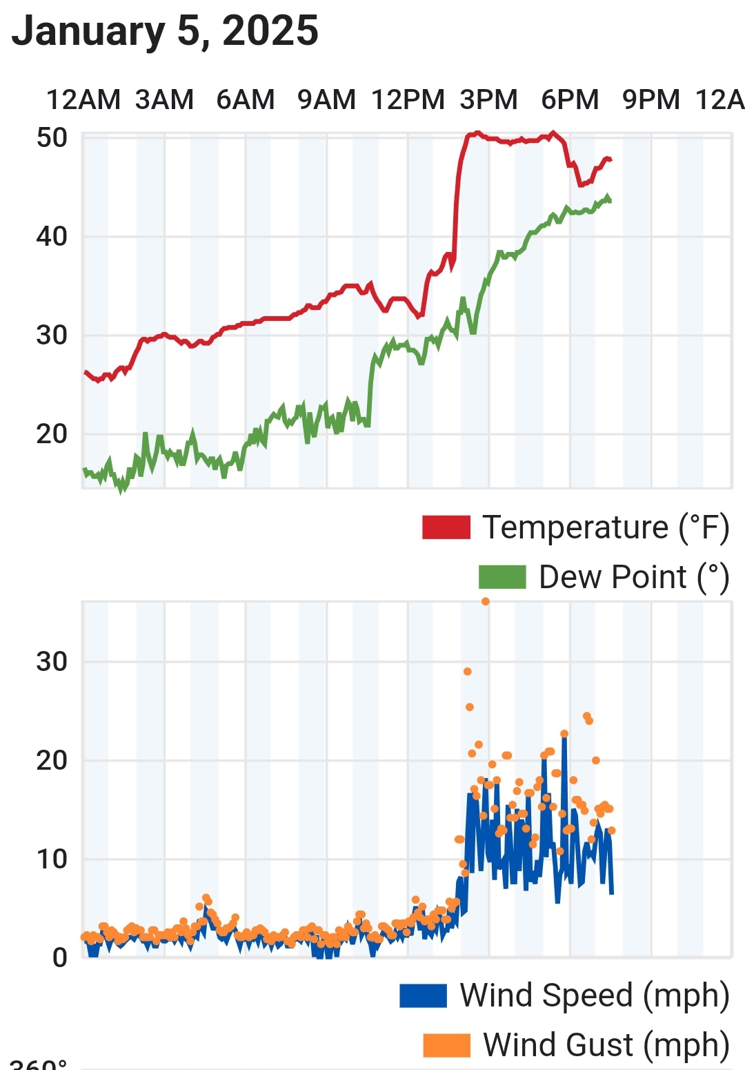
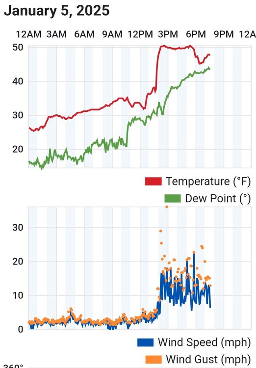
For those who are new or possibly never saw how downsloping can affect things along the foothills. From 32° to 51° in about an hour.
-
Yeah...I've always considered Pensacola are the pivot point. If it catches it before that point..not good. Around that area...sweet spot. It's one of the reasons local Mets blowed the Forcast for the storm I won't name...thought would pull too far NW...but didn't happen.
-
Fuse was lit that run...definitely an all in hand or go big or go home solution.
-
Personally at this range I would take what the 18z GFS spit out and run...energy diving into the backside of a low near Pensacola. Would have a some mixing potential on front side..but once the coma head passed over should be fun times...just need 500 to dig a touch more.
-
Yeah plus downsloping...this end of county it is extremely rare event to see ice.
-
Temps are in the mid 50's up next to the state line on the Cherohala Skyway
-
Nice balmy 49° here lol
-
Still not sold on this system for the east side of the state...think western guys will do ok. If the system is too consilidated...cutter city and waa (more interaction with the GL low)...too sheared and lift into the DGZ may become an issue. As per usual...tight window it has to work with.
-
12z UKIE on board similar to other suite models....just a little further south (where you want it at this range)
-
Better run for it anyway...kind of shart itself as it moved out of N. MS..but still statewide.
-
0z Ukie doesn't look to be messing around like the other lol.
-
CMC...looks similar to GFS location wise for accumulation...just a little less totals.
-
0z GFS wants to crawl across gulf..not sure what to think of it lol. New run different solution.
-
28.6 DP 18.0 Temp has risen 2.4 in last hour here
-
Latest RAP is close...HRRR is too warm here with current temps. Both have the leading precipitation as snow along 40 and north in central valley.
-
Temps here currently are closer to the RGEM than the NAM 3k...down to 29.
-
There's one thing on the GFS that we have all seen before and 9x out 10 turns into Lucy pulling the football....Great Lakes Low = ominous death signal for the southern valley.
-
Sorry just noticed thread...mods feel free to move my other post here. Basically the lee side low effect on backend has me somewhat intrigued especially for the plateau counties.
-
Check please lol...I would be more than happy with this winter after that.
-
GFS spitting out a heavy hitter