TellicoWx
-
Posts
2,283 -
Joined
-
Last visited
Content Type
Profiles
Blogs
Forums
American Weather
Media Demo
Store
Gallery
Everything posted by TellicoWx
-
As far as 500...GFS had some minor differences but not enough...still semi holding back unlike the ICON
-
Crazy part is, icon may have under done the totals...column is 100% saturated all way thru 500 = half dollars falling
-
00z ICON was way more juiced at 500
-
0z suite starting...looking for some continuity from 18z. It used to be you could almost count on some kind of jump one way or another somewhere around 72 hours out...almost like a truncation point.
-
Stating to see some big dogs...GEFS had 1 or 2 as well.
-
500 started to roll out with the surface but held back a little unlike the icon coming all the way. Overall a decent size step in right direction..also eastern valley had moisture still moving up it even tho map showed no precip
-
Instead of dry slot in N AR...it's in corpus Christie at 90
-
18z GFS looks alot better at 84, similar to RGEM so far
-
Starting to wonder if models are holding that piece at 500 back way too long. If it comes out together with the surface and opens the returns off the Gulf instead of Mexico..then the fuse is lit again.
-
Would have loved to seen what the RGEM looked like rolled forward...best looking 500 over TX at 84 by far
-
Significant changes at 500 on the icon..that's what we need from this storm. 500 rolls forward with the surface low....we don't end up with the massive dry slot.
-
The divergence between the Euro and GFS happens here for the east..if the GFS is correct, the eastern valley would benefit from the moisture flow coming up as part of the energy transfer toward the coast...Euro keeps the lid shut.
-
Unless something drastically changes at 500...there is no moisture transport into the DGZ for eastern half of the state with the way the system is occluding on approach. The only way to overcome the 500 is with UVV's and so far that's not showing up. Hope I'm 100% wrong but this system has sleet fest written all over it to me. 500 really hasn't changed much the last 24 hrs roughly. Folks from west to western half middle TN look to be in better shape (closer to the 500 comma). 12z GFS and EURO 500 RH
-
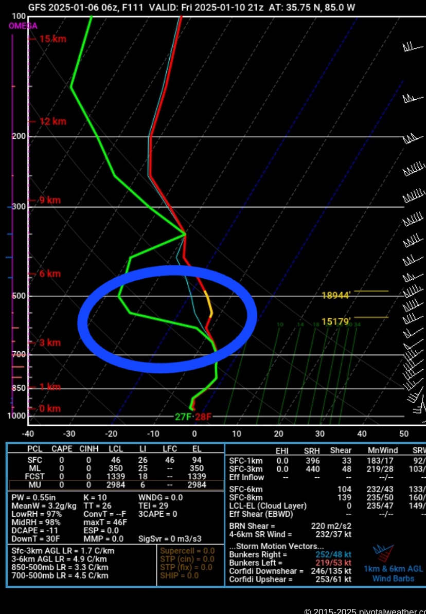
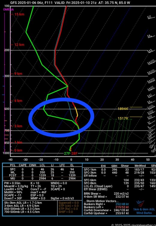
Sounding from the 6z over the central valley at hr 111 (map shows snow, sounding says otherwise). For those that are new or have not read soundings much...The DGZ is the dendric growth zone, or where the temp passes between the -12 to -17 layer. To form snow flakes, that are has to saturate..if not precipitation can still form but as a rain drop instead. If temp is below freezing the rest of the way to the surface, you get sleet or even freezing drizzle. Usually happens as snow is winding down, and you get that brief period of pixy dust or icing even tho it's still 25° outside. On the sounding I circled the DGZ (yellow section of the red temp line), significant dry air in that region = no snowflakes.
-
While the snow map looks nice on the 6z GFS, I would use alot of caution. The soundings up the valley and plateau have significant dry layer in the DGZ. If anywhere close to right that wouldn't be snow...more like a freezing rain/sleet type anywhere across East TN. Plus side is no warm nose....column is sub 32 even across the southern valley.
-
Definitely need to keep an eye on the moisture return between 500 and 700..dry air in that area is goofing around to varying degrees across all the models. Once the comma head arrives, that issue is resolved.
-
@John1122 northern end of plateau..DGZ issue, never fully saturates, so Sharpy reads that as sleet/frz rain
-
CMC is just hellbent on turning SE into an ice block at some point this winter..did something similar with today's system
-
Did it saturate up into the DGZ...haven't checked up your way since you don't usually have that issue.
-
At 120..can see a faint reflection at 850 of a piece of energy over SE MO..playing wacky games with the 850s...GFS doesn't have that feature.
-
Take away the DGZ issue and covert to snow...would line up with what would be expected climo (TX area that's nailed, LP pivoting near FL Panhandle, and backside energy/coma head)..6"-10" valley wide.
-
Agree...just kinda cranky at my old age lol...There's a steep road that goes straight uphill in town here that we use to sled down as a kid. Now over a decade since we had enough snow on the road to close it down for the kids.
-
Watched the sounding on the southern end of the valley...had an issue with getting the moisture into the DGZ...no real sign of any major warm nose. Looked more like a lift issue causing frz drizzle sounding.
-
Kinda feel like @John1122lately...hard to watch what used to be money on some of these models (Dallas getting hammered ex), just to go splat kinda right when it crosses the MS river.