

TellicoWx
-
Posts
2,283 -
Joined
-
Last visited
Content Type
Profiles
Blogs
Forums
American Weather
Media Demo
Store
Gallery
Everything posted by TellicoWx
-
11/12/19 Tennessee Valley Early Winter Event
TellicoWx replied to BlunderStorm's topic in Tennessee Valley
Comparing current temps in Crossville to the 18z Euro meteogram, the front looks to be about an hour ahead of schedule. Question now is does the moisture back over MS fill in and pivot to the north as modeled. -
11/12/19 Tennessee Valley Early Winter Event
TellicoWx replied to BlunderStorm's topic in Tennessee Valley
Front has reached Crossville -
11/12/19 Tennessee Valley Early Winter Event
TellicoWx replied to BlunderStorm's topic in Tennessee Valley
Yeah, most setups seems like forever to reach Dayton/Spring City when watching my area -
11/12/19 Tennessee Valley Early Winter Event
TellicoWx replied to BlunderStorm's topic in Tennessee Valley
Interested to see how quickly it can spill over -
11/12/19 Tennessee Valley Early Winter Event
TellicoWx replied to BlunderStorm's topic in Tennessee Valley
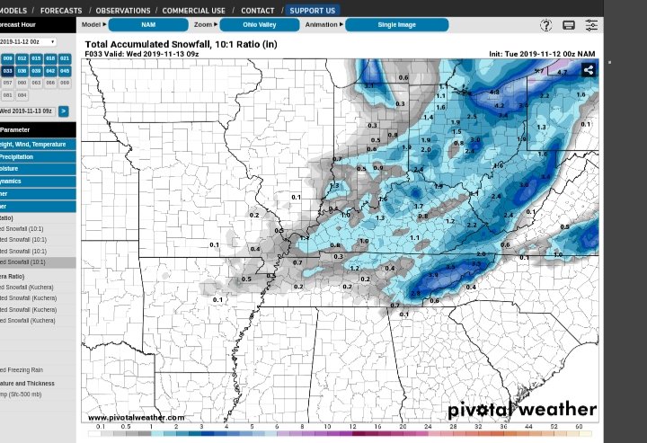
NAM and 3k still good for the valley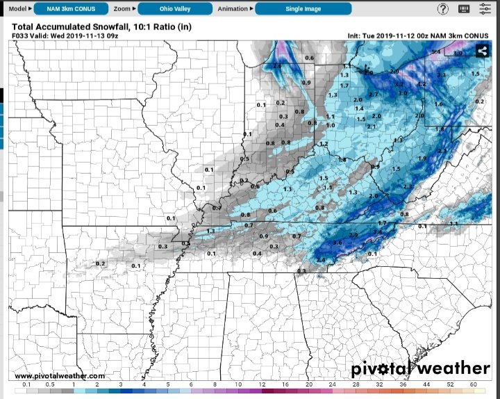
-
11/12/19 Tennessee Valley Early Winter Event
TellicoWx replied to BlunderStorm's topic in Tennessee Valley
Usually a good indicator to how the NAM is gonna go -
11/12/19 Tennessee Valley Early Winter Event
TellicoWx replied to BlunderStorm's topic in Tennessee Valley
Heavy sleet reported in Camden, TN -
11/12/19 Tennessee Valley Early Winter Event
TellicoWx replied to BlunderStorm's topic in Tennessee Valley
00z RAP and 18z Euro -
11/12/19 Tennessee Valley Early Winter Event
TellicoWx replied to BlunderStorm's topic in Tennessee Valley
00z HRRR not blinking on eastern valley so far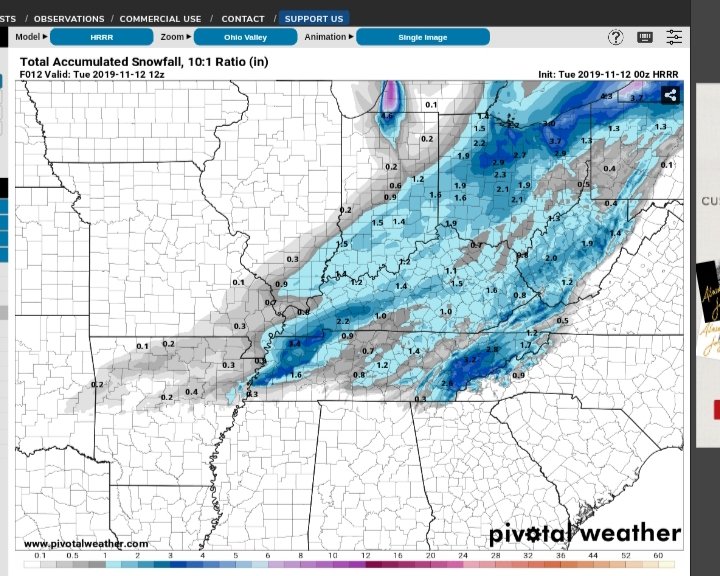
-
11/12/19 Tennessee Valley Early Winter Event
TellicoWx replied to BlunderStorm's topic in Tennessee Valley
A lot of bright banding between Clarksville and Jackson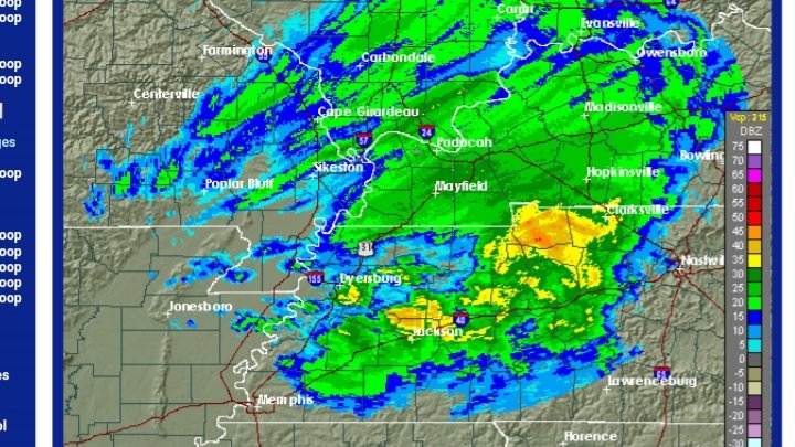
-
11/12/19 Tennessee Valley Early Winter Event
TellicoWx replied to BlunderStorm's topic in Tennessee Valley
Here's a PWS graph from near Paris, TN..looks like a fairly steady few deg drop per hour. -
11/12/19 Tennessee Valley Early Winter Event
TellicoWx replied to BlunderStorm's topic in Tennessee Valley
They pulled the trigger cause, like MRX, they were counting on the warmth ahead of the front to keep roadways clear..not happening, areas they have fell below 32 are already freezing up. -
11/12/19 Tennessee Valley Early Winter Event
TellicoWx replied to BlunderStorm's topic in Tennessee Valley
Yeah Tom Meiners with WBBJ shared -
11/12/19 Tennessee Valley Early Winter Event
TellicoWx replied to BlunderStorm's topic in Tennessee Valley
Nws Memphis issuing a WWA for all middle TN until midnight -
11/12/19 Tennessee Valley Early Winter Event
TellicoWx replied to BlunderStorm's topic in Tennessee Valley
Storm spotter video out of Lake Co in NW TN showing moderate snow and roadways beginning to turn white. -
11/12/19 Tennessee Valley Early Winter Event
TellicoWx replied to BlunderStorm's topic in Tennessee Valley
Freezing rain, sleet, snow beginning to stick to elevated surfaces in NW TN -
11/12/19 Tennessee Valley Early Winter Event
TellicoWx replied to BlunderStorm's topic in Tennessee Valley
22z HRRR doubling totals over NW TN -
11/12/19 Tennessee Valley Early Winter Event
TellicoWx replied to BlunderStorm's topic in Tennessee Valley
Lots of sleet reports across northern AR with some snow reports mixed in. Bridges are icing up quickly. -
11/12/19 Tennessee Valley Early Winter Event
TellicoWx replied to BlunderStorm's topic in Tennessee Valley
Intial cold push has entered NW TN, basically extends from Clarksville sw to Humboldt and just north of Memphis...should be a steady gradual drop behind it. -
11/12/19 Tennessee Valley Early Winter Event
TellicoWx replied to BlunderStorm's topic in Tennessee Valley
Looking at PWS up stream it's acting like a double front, with the true arctic front lagging several hours behind the initial cold push. Energy/lift is riding between the two, more along the true arctic front. Looking at PWAT surging up the Apps (visible in the increase in moisture on the NC side of the TN/NC line as the arctic front is catching the lead push) and isobars backing down the front as it pulls in to the area, piece of energy is riding up the Apps enhancing the lift along east TN increasing the total. -
11/12/19 Tennessee Valley Early Winter Event
TellicoWx replied to BlunderStorm's topic in Tennessee Valley
So far on obs at the surface behind the front, the dry air is lagging behind by roughly by about 5-6 hrs. My thoughts right now are about an 1" accumulation for central valley north, plateau/foothills Smokies 1"-2", with areas above 1500' (valley/plateau/mtns) having the best chance to over perform. -
11/12/19 Tennessee Valley Early Winter Event
TellicoWx replied to BlunderStorm's topic in Tennessee Valley
0z GFS says congrats to Knox Co...6.3" lol -
Tennessee Valley 2019 Fall Speculation/Forecasting
TellicoWx replied to AMZ8990's topic in Tennessee Valley
Just one example across W KY/Boothill area from one of the HRW models (noticeable increases on all the HRW, NAM, so on):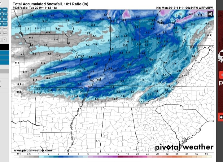
- 574 replies
-
- 1
-

-
- early winter
- leaves changing
- (and 3 more)
-
Tennessee Valley 2019 Fall Speculation/Forecasting
TellicoWx replied to AMZ8990's topic in Tennessee Valley
May not amount much for us, but one thing I have noticed since yesterday with this system, is the mesoscale models have way underperformed on guidance up until 18-24 hrs out. Yesterday it was the upper Ohio valley (great read in their sub forum of how the nam was very late joining the globals, specifically the Euro, on guidance). Tonight there is a large uptick over Western KY/AR MO boothill once in that 18-24 timeframe. Seems like the mesos are playing catch up with the speed of changeover and moisture being squeezed out. May mean nothing here, but interested in watching how it plays out.- 574 replies
-
- 2
-
-
- early winter
- leaves changing
- (and 3 more)
-
Tennessee Valley 2019 Fall Speculation/Forecasting
TellicoWx replied to AMZ8990's topic in Tennessee Valley
You will really like the 12z lol

