

TellicoWx
-
Posts
2,283 -
Joined
-
Last visited
Content Type
Profiles
Blogs
Forums
American Weather
Media Demo
Store
Gallery
Everything posted by TellicoWx
-
NAM vs the Euro cage match storm, Feb 20 - 21
TellicoWx replied to Holston_River_Rambler's topic in Tennessee Valley
Sounding difference here between the 12z 3k and 14z HRRR for 12p is like night and day...HRRR warms to 41, currently 34.6..good luck with that lil buddy. HRRR (MRX in house model today lol jk). -
NAM vs the Euro cage match storm, Feb 20 - 21
TellicoWx replied to Holston_River_Rambler's topic in Tennessee Valley
Moderate snow falling here at 1800' (drove 4 miles from house up to Coker Creek) temp 34.6 so it's all melting. House is 37 and all rain at 980'. Wauchessi Mtn station (2050' sitting at 33.4 and dropping (so freezing line is moving down), when was in Coker Creek 3/4 of Wacheesi was hidden in the snow clouds for lack of better word lol. Quessing the fire tower there is already picking up accumulations. -
NAM vs the Euro cage match storm, Feb 20 - 21
TellicoWx replied to Holston_River_Rambler's topic in Tennessee Valley
That is the dry, colder air advecting in the mid/lower levels...as it pushed to my south temp went from 40/37 to 34/30 -
NAM vs the Euro cage match storm, Feb 20 - 21
TellicoWx replied to Holston_River_Rambler's topic in Tennessee Valley
Current Wetbulbs show the plateau right at 32..central/southern valley 34-36 is uniform from Knox Co south. Looks like pretty much everyone will see some flakes, not sure how much (if any) can accumulate outside plateau/mtns. -
NAM vs the Euro cage match storm, Feb 20 - 21
TellicoWx replied to Holston_River_Rambler's topic in Tennessee Valley
Have been studying weather for a hair over 25yrs and this is one of the reasons that makes E. TN so hard to forecast. For whatever reason (topography/angle of dry advection/etc), a small bubble of moisture has been trapped over southern Monroe Co into Polk Co all night. We can't seem to advect the dry air SE of Hwy 411. DP has been between 35-40 all night. -
NAM vs the Euro cage match storm, Feb 20 - 21
TellicoWx replied to Holston_River_Rambler's topic in Tennessee Valley
45/38 here....temps have leveled off, with DP climbing last hour or so. Definitely dont like where I'm sitting. -
NAM vs the Euro cage match storm, Feb 20 - 21
TellicoWx replied to Holston_River_Rambler's topic in Tennessee Valley
Cut qpf in half -
NAM vs the Euro cage match storm, Feb 20 - 21
TellicoWx replied to Holston_River_Rambler's topic in Tennessee Valley
00z 3k dropped totals as well over the eastern valley -
NAM vs the Euro cage match storm, Feb 20 - 21
TellicoWx replied to Holston_River_Rambler's topic in Tennessee Valley
00z NAM cut totals compared to 18z -
NAM vs the Euro cage match storm, Feb 20 - 21
TellicoWx replied to Holston_River_Rambler's topic in Tennessee Valley
1.5" to 2.5" is a fairly big jump..thanks -
NAM vs the Euro cage match storm, Feb 20 - 21
TellicoWx replied to Holston_River_Rambler's topic in Tennessee Valley
What was the prior mean? -
NAM vs the Euro cage match storm, Feb 20 - 21
TellicoWx replied to Holston_River_Rambler's topic in Tennessee Valley
The lower the better lol..this isn't a warm adv system so I would be comfortable around 24/25 for sure (quicker onset for snow plus could become road issue) -
NAM vs the Euro cage match storm, Feb 20 - 21
TellicoWx replied to Holston_River_Rambler's topic in Tennessee Valley
18z Euro: -
NAM vs the Euro cage match storm, Feb 20 - 21
TellicoWx replied to Holston_River_Rambler's topic in Tennessee Valley
Dont quite remember a spread this big on the EPS 24hrs or less out....0" to 6" lol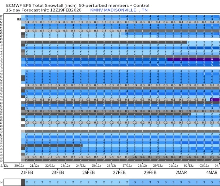
-
NAM vs the Euro cage match storm, Feb 20 - 21
TellicoWx replied to Holston_River_Rambler's topic in Tennessee Valley
Sounds right...PWS in Athens is 49/31 -
NAM vs the Euro cage match storm, Feb 20 - 21
TellicoWx replied to Holston_River_Rambler's topic in Tennessee Valley
So seems most people are running ~3° colder currently on dews vs the coldest model. Yeah I definitely think you guys go WWA if radiational cooling stays on track. -
NAM vs the Euro cage match storm, Feb 20 - 21
TellicoWx replied to Holston_River_Rambler's topic in Tennessee Valley
Will be interesting to see play out tonight...example: Athens area bottoms DP at 32 overnight on 18z NAM -
NAM vs the Euro cage match storm, Feb 20 - 21
TellicoWx replied to Holston_River_Rambler's topic in Tennessee Valley
Interesting...NAM had 42/27 for northern plateau @6 cst -
NAM vs the Euro cage match storm, Feb 20 - 21
TellicoWx replied to Holston_River_Rambler's topic in Tennessee Valley
18z NAM sounding @7p for the same general area...DP already below sounding -
NAM vs the Euro cage match storm, Feb 20 - 21
TellicoWx replied to Holston_River_Rambler's topic in Tennessee Valley
Dew points starting to crash here along the southern foothills..I agree, if the DP can get down around ~25 (no waa with system) plus radiational cooling and the inverted trof (may aide rates)..there's slot of uncertainty if the models are right about the temps..some leeway to go colder imo. PWS in Loudon showing the DP crash moving down the valley -
NAM vs the Euro cage match storm, Feb 20 - 21
TellicoWx replied to Holston_River_Rambler's topic in Tennessee Valley
18z GFS sounding went from 42 to 36 at surface vs 12z due to more moisture/evap cooling..still a little too warm (for southern valley) -
NAM vs the Euro cage match storm, Feb 20 - 21
TellicoWx replied to Holston_River_Rambler's topic in Tennessee Valley
18z Goofy starting to join the party -
NAM vs the Euro cage match storm, Feb 20 - 21
TellicoWx replied to Holston_River_Rambler's topic in Tennessee Valley
Yeah, I would cut the NAM totals by 1/2 to 1/3..so 1"-2" in central/southern valley (2"-3" in those areas where ridge tops get to 1200'-1500' plus). Last weeks soundings had Chatt around 32/33 (fairly spot on with actual observed)..it was close enough to 32 for higher rates to impact the roads. 34/35 is just too high for rates to cool, still could see shaded areas of roadways try to accumulate. -
NAM vs the Euro cage match storm, Feb 20 - 21
TellicoWx replied to Holston_River_Rambler's topic in Tennessee Valley
Looking at all the soundings for central/southern valley and plateau, I think that was a good call. WWA, WSW, and WSW products are mainly influenced by travel (2"-3" of snow of the grass while pretty has little impact on the public). Most soundings are in the 34/35 range, couple degrees warmer than last weeks system..not ideal for accumulation on the roadways. Think they went a little too low for accums on grass and think the plateau will go to an advisory at some point. -
NAM vs the Euro cage match storm, Feb 20 - 21
TellicoWx replied to Holston_River_Rambler's topic in Tennessee Valley
Only ones I would think could, an uneducated guess, is 3k, HRRR, so on...just due to their very low resolutions

