

TellicoWx
-
Posts
2,283 -
Joined
-
Last visited
Content Type
Profiles
Blogs
Forums
American Weather
Media Demo
Store
Gallery
Everything posted by TellicoWx
-
Buddy sent me this from up on the Skyway...TN side roads are clear, NC side doesn't plow or brine theirs.
-
January 7 - 8 ULL obs and nowcast
TellicoWx replied to Holston_River_Rambler's topic in Tennessee Valley
38° here, not looking for much of anything here...congrats to those who scored, and good luck to those to the north -
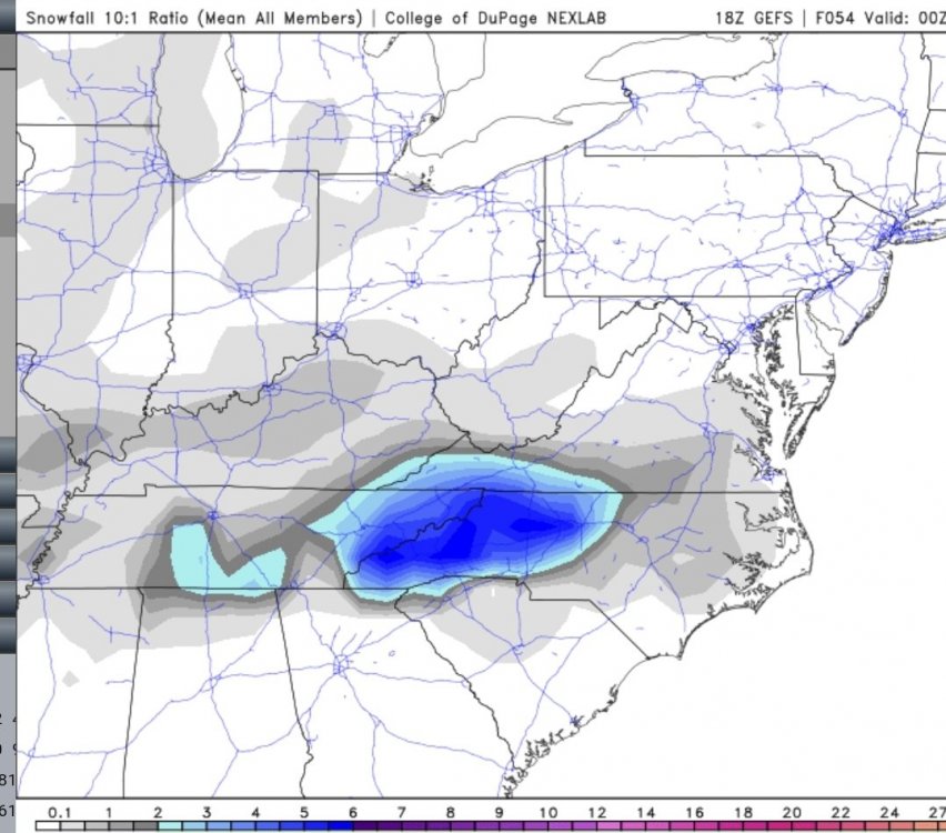
Something interesting about the GFS OP...even the 18z GEFS doesn't agree with it (picked up the southern middle TN snow). Usually this close an OP and ENS doesn't disagree this much. Just thought it was interesting. 18z GEFS
-
HRRR never picked up the snowfall south of Nashville until 22z really...if I was on the southern plateau (Crossville south), I would be really happy...wouldn't be surprised to see some very hefty amounts there.
-
Problems being reported all over southern middle TN on the roads (snow covered) as sunsets.
-
January 7 - 8 ULL obs and nowcast
TellicoWx replied to Holston_River_Rambler's topic in Tennessee Valley
Signal Mtn switched over straight from rain to snow (no mix) about an hour ago. Roads in Hohenwald beginning to be a problem as sunsets (snow covered) -
January 7 - 8 ULL obs and nowcast
TellicoWx replied to Holston_River_Rambler's topic in Tennessee Valley
Maury Co on Hwy 43 -
Even the GFS upgrade says the old system is lost
-
Either GFS/UKIE are going to pull the ultimate coup, or they are completely lost...rest modeling world has generally same are from southern middle TN, running up the plateau, and points east
-
-
Euro not backing down
-
Compton, AR (NW AR) reporting 4.3" now..only model that got that right...3k NAM. Time to watch the actual vs ops out west.
-
I've kept my hopes muted with this one lol. Big boom or bust potential with this one for me..1°-2° will be a world of difference. We will find out around midnight if the changeover begins to occur..0"-6" here we come lol
-
Yeah noticed that too..wonder if it's just due to the snapshot at that particular hour and the dendrite zone is beginning to dry out.
-
I can't figure the GFS out...has almost the same RH/PWAT/UVV as the RGEM/NAM...just never produces the precip
-
0z RGEM,...columns moist/ no dry air issue. Difference with the surface temp is the precip rate isn't as high on the RGEM vs NAM (central/southern valley)
-
Yeah, looking at the sounding for here..looks like it has the moisture like the NAM..but it doesn't generate quite the same dynamic cooling right at the valley floor..that 1-2° makes the world of difference for the central/southern valley.
-
If the dry air is right at the surface then yes..but on 18z, the bigger separation is in the mid levels..if this was more woundup surface low vs ULL then the available moisture would be more plentiful. Since it's an ULL..we need the mid levels to be as moist as possible at the start. There has been hints at modeling on a slight downslope component as well..that would be another issue the ULL would have to fight off..but that's more track dependent and angle the winds are coming across the mtns from NC side.
-
Green line is the DP...Red line is the temp...as the line moves up the chart, it's like a weather balloon rising...shows how each layer is responding. Chart on top is 18z...as you follow the green/red line up, they separate (shows the dry air just off the ground). 0z the entire column is moist (green/red line together). The temp at the start of the lines when comparing the two, shows how if we can get the moisture feed right...dynamic cooling (snow melting as it falls, cooling the lower atmosphere near the ground) helping the lower elevation be 4° colder. The 0 line is the dark blue faint line running up the chart at an angle...if the temp line stays below or right at that line on its entire path, then you get snow...if it goes to the right of the 0 line (warmer temps) then you get mix or rain.
-
Difference the moisture feed makes...18z vs 0z (south/central valley). The dry air out in front was significantly less when the ULL pivoted east near AR on the 0z.
-
0z NAM
-
Still snowing across NE TN at 66..already closing in on 12" at MRX
-
Good run for the entire eastern valley
-
Chatt gets NAM'd again lol
-
Moisture feed looks better on 0z NAM compared to 18z


