TellicoWx
-
Posts
2,283 -
Joined
-
Last visited
Content Type
Profiles
Blogs
Forums
American Weather
Media Demo
Store
Gallery
Everything posted by TellicoWx
-
UKie Op only runs out to 144
-
More as sleet, yes. Depends on how thick the surface layer is. It's waves overrunning the boundary, southerly flow in the mid levels..so wouldn't be a cutter unless you can get cyclogenesis at the surface
-
If I was you folks west of the plateau, I would be very concerned. Been a long time since I had to look at the research OU did. While the study mainly focused on the southern plains, it held true during the last ice storm here in the valley. Models tend to do two things when dealing with this type of true arctic cold...they underestimate how far the low level cold extends (while our resolution has improved over the years, globals still don't have the resolution to sim the very lowest levels with a great deal of accuracy this far in advance..so they bust to the high side) and two they scour it out to quickly for the same reason (surface level resolution). Only thing saving the eastern valley is the plateau, but if the shallow layer arctic air is a tad deeper, it will spill over that as well.
-
Think they have stage fright from the last couple systems (especially in the valley)
-
I honestly don't get any part of their Afd for tonight, seems like they made every statement possible as to why not to issue anything outside their normal areas. 6z HRRR looks off to me..if it's downsloping, then NC side doesn't add up. While I think the 6z NAM is overdone (although their is support from several 0z GEFS members), I don't see anything to argue against winter products I-40 north and plateau west.
-
Poor MRX, soon as they mention the NAM warm nose by name, it spits this out lol especially the NAM show a significant warm nose that protrudes varying distances north for several hours.
-
Wish I could find the surface analysis for this...but a similar situation where you had a 1050 high move from the Rockies east, with a stalled frontal boundary right along the Apps with multiple waves..Jan 29 - Feb 1, 1951.
-
True Siberian air is very shallow..if modeling is even remotely close, it's either gonna back right against the plateau or the Apps. There's very few instances where I can remember NWS office raising a red flag like CPC did a week in advance.
-
Besides the snow...this would be devastating to the South
-
Prior post was in wrong thread..moved it to the right one
-
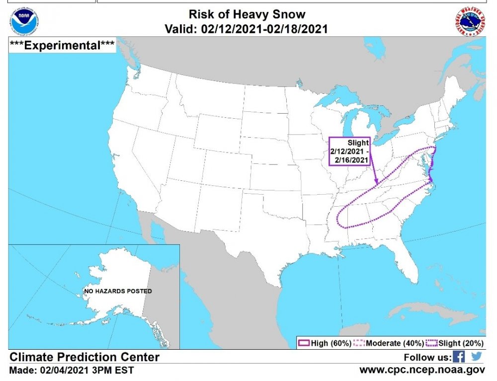
Posted this in wrong thread...don't remember CPC posting a heavy snow threat 8 days in advance before A strong cold front is forecast to push well south into the Gulf of Mexico later next week with an increasing chance that a wave of low pressure develops along the front by Feb 12. If a surface low develops, anomalously cold temperatures would support snow to the northwest of its track. A negatively tilted 500-hPa trough across the east-central U.S. along with subtropical ridging over the southwestern Atlantic supports a continued risk of winter weather across the Southeast and mid-Atlantic. The week-2 analog tools (Canadian and ECMWF ensemble means) imply this outcome with elevated probabilities of above normal precipitation for these areas. Based on these factors, a likely outbreak of Arctic Air, and 24-hour precipitation amounts of a 0.25 inch or more, liquid equivalent, from the ensemble means at varying daily intervals, a slight risk of heavy snow (2 to 4 inches, or greater) is posted for the Piedmont areas of the Southeast, Southern Appalachians, and mid-Atlantic.
-
1985 was when the Tellico River froze solid...have old family albums with pics of cars/trucks driving up the middle of the river on the ice. Only time I have ever known the water to completely freeze and stop flowing at the Bald River Falls.
-
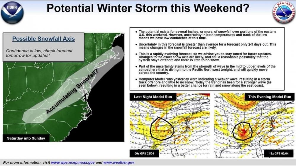
From WPC:
-
Lock it in then...marginal temps is a sure sign something is looming in the great valley..lol jk
-
This upcoming setup is reminding more and more of the "good ol' days"...even the loss of the pattern in the mid range (remember when people would get hyped, then line up on the cliffs, just to be reeled back in mid jump). Great job today by everyone posting btw.
-
Same here..also goes for posting trends on ensembles for me...usually goes exactly opposite on the next run after I post it lol
-
On side note...got light sleet falling here now
-
Hr 72-96 all winter long has had major changes occur at 500...this seems par for the course so far. Ride the ensembles until within hr 48.
-
What's the EPS members look like Holstons? Don't have access...will kinda tell if GEFS is out to lunch.
-
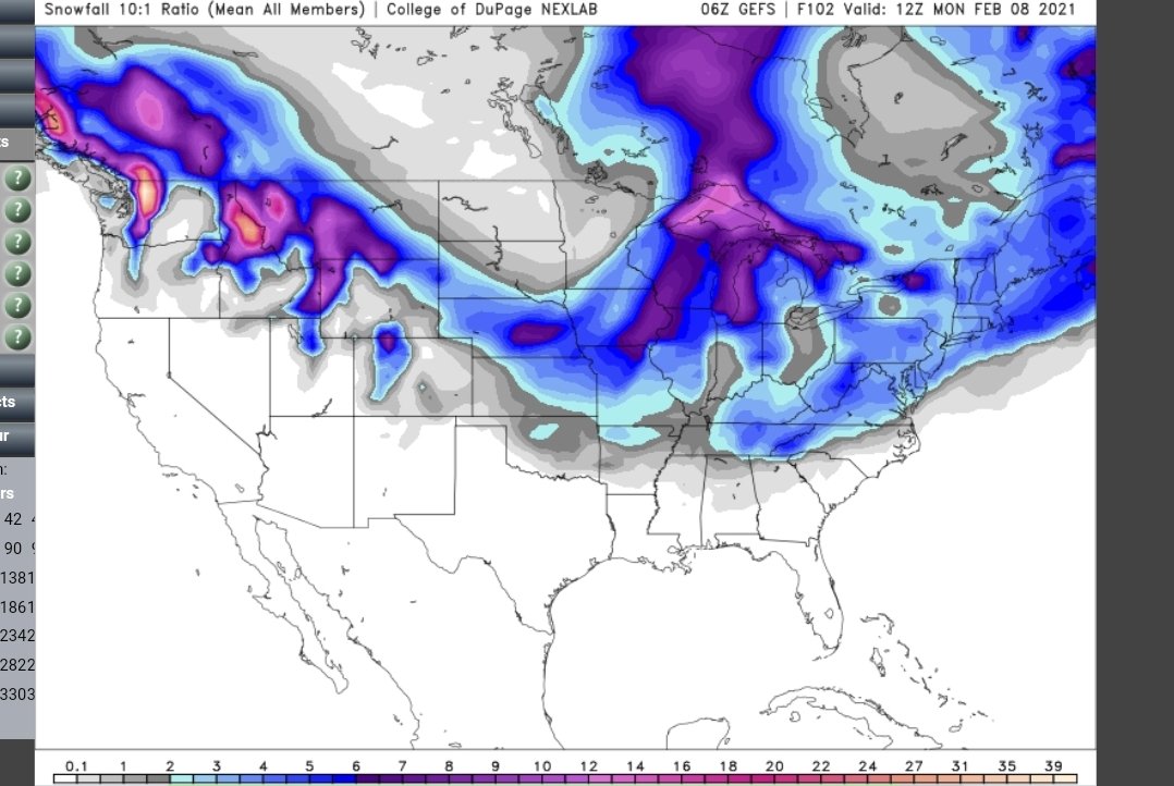
6z GEFS @102 mean and individual members...more members in the have column vs 0z.

-
0z Euro would be a monster storm for the SE if it played out that way around the 12th
-
0z Euro is a tad late, popping a low (wasn't there on the 12z) off GA/SC coast
-
GEFS is kinda split into a couple camps for the beginning of the week...so maybe V16 isnt completely lost
-
18z GEFs..while the run/run has ebbed back and forth...the last couple days has seen the overall mean slowly get better for the central/western areas as well..decent trend for the entire forum.
-
Solar~QBO~MJO~ENSO~rest of the teleconnections is what is being studied..As the solar winds/flares hit the upper tropo (QBO), it propagates downward effecting the MJO. Depending how the MJO reacts to the descending phase of the winds, it effects the upwelling of the ocean (effecting the ENSO),which in turn effects where the ridges/troughs are most likely to form..something happened to the solar influence around 2015/16...throwing the sequence out of balance. Think of how badly the analogs cold/warm LR outlooks have performed the last 5 yrs.