TellicoWx
Members-
Posts
2,283 -
Joined
-
Last visited
Content Type
Profiles
Blogs
Forums
American Weather
Media Demo
Store
Gallery
Everything posted by TellicoWx
-
If I was you folks west of the plateau, I would be very concerned. Been a long time since I had to look at the research OU did. While the study mainly focused on the southern plains, it held true during the last ice storm here in the valley. Models tend to do two things when dealing with this type of true arctic cold...they underestimate how far the low level cold extends (while our resolution has improved over the years, globals still don't have the resolution to sim the very lowest levels with a great deal of accuracy this far in advance..so they bust to the high side) and two they scour it out to quickly for the same reason (surface level resolution). Only thing saving the eastern valley is the plateau, but if the shallow layer arctic air is a tad deeper, it will spill over that as well.
-
Think they have stage fright from the last couple systems (especially in the valley)
-
I honestly don't get any part of their Afd for tonight, seems like they made every statement possible as to why not to issue anything outside their normal areas. 6z HRRR looks off to me..if it's downsloping, then NC side doesn't add up. While I think the 6z NAM is overdone (although their is support from several 0z GEFS members), I don't see anything to argue against winter products I-40 north and plateau west.
-
Poor MRX, soon as they mention the NAM warm nose by name, it spits this out lol especially the NAM show a significant warm nose that protrudes varying distances north for several hours.
-
Prior post was in wrong thread..moved it to the right one
-
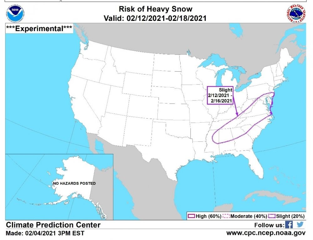
Posted this in wrong thread...don't remember CPC posting a heavy snow threat 8 days in advance before A strong cold front is forecast to push well south into the Gulf of Mexico later next week with an increasing chance that a wave of low pressure develops along the front by Feb 12. If a surface low develops, anomalously cold temperatures would support snow to the northwest of its track. A negatively tilted 500-hPa trough across the east-central U.S. along with subtropical ridging over the southwestern Atlantic supports a continued risk of winter weather across the Southeast and mid-Atlantic. The week-2 analog tools (Canadian and ECMWF ensemble means) imply this outcome with elevated probabilities of above normal precipitation for these areas. Based on these factors, a likely outbreak of Arctic Air, and 24-hour precipitation amounts of a 0.25 inch or more, liquid equivalent, from the ensemble means at varying daily intervals, a slight risk of heavy snow (2 to 4 inches, or greater) is posted for the Piedmont areas of the Southeast, Southern Appalachians, and mid-Atlantic.
-
-
Lock it in then...marginal temps is a sure sign something is looming in the great valley..lol jk
-
Solar~QBO~MJO~ENSO~rest of the teleconnections is what is being studied..As the solar winds/flares hit the upper tropo (QBO), it propagates downward effecting the MJO. Depending how the MJO reacts to the descending phase of the winds, it effects the upwelling of the ocean (effecting the ENSO),which in turn effects where the ridges/troughs are most likely to form..something happened to the solar influence around 2015/16...throwing the sequence out of balance. Think of how badly the analogs cold/warm LR outlooks have performed the last 5 yrs.


