

TellicoWx
-
Posts
2,283 -
Joined
-
Last visited
Content Type
Profiles
Blogs
Forums
American Weather
Media Demo
Store
Gallery
Everything posted by TellicoWx
-
January Medium-Long Range Discussion
TellicoWx replied to Holston_River_Rambler's topic in Tennessee Valley
Jumped the storm SE again, as you guys have said over the past couple days or so, seems to be something this winter to that. With those lofty numbers shown just across the MS river last few days of runs, it will be interesting to see if west TN starts getting into the game for anything within 150 hrs. -
January Medium-Long Range Discussion
TellicoWx replied to Holston_River_Rambler's topic in Tennessee Valley
Creamsicle is back on the 12z GEFS lol -
January Medium-Long Range Discussion
TellicoWx replied to Holston_River_Rambler's topic in Tennessee Valley
12z GEFS looks alot better thru the ext (run not complete quite yet), especially for the central and west TN folks. Instead of one storm skewing the mean and the rest kinda of blah, almost each member has some for of storm/s. One member even pushes 2"-4" right to the gulf/FL panhandle area. When ensembles start getting into the 4"-5" means (west/central TN), usually something is coming -
January Medium-Long Range Discussion
TellicoWx replied to Holston_River_Rambler's topic in Tennessee Valley
Probably should be in banter, but noticed a large jump in the 00z GEFS overall run mean..so piqued my interest. And there it was, Member 8 aka The TN Mauler. One member jumped the entire mean 2+ inches (pegs out COD's accum chart)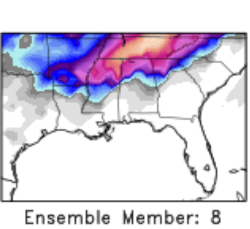
-
January Medium-Long Range Discussion
TellicoWx replied to Holston_River_Rambler's topic in Tennessee Valley
12z GEFS screams model chaos after the first system...will be very hard for it to determine where/how to interact with this many lows parading across the country. -
January Medium-Long Range Discussion
TellicoWx replied to Holston_River_Rambler's topic in Tennessee Valley
Have to get the 1st system out of the way, but if the GFS can consolidate the energy with the southern piece of energy like the CMC, then the 2nd system could get very interesting. -
January Medium-Long Range Discussion
TellicoWx replied to Holston_River_Rambler's topic in Tennessee Valley
00z CMC looking better for the next system -
January Medium-Long Range Discussion
TellicoWx replied to Holston_River_Rambler's topic in Tennessee Valley
Yep, and the Southern Jet stays active even then...would be a great potential setup. -
January Medium-Long Range Discussion
TellicoWx replied to Holston_River_Rambler's topic in Tennessee Valley
Seems to always be the big fly in the ointment on these setups. 12z CMC is a great visual for seeing how much of a difference they can make...system #1 (GL Low) valley struggles at lower levels...system #2 (HP over the top) slider with better thermals. -
January Medium-Long Range Discussion
TellicoWx replied to Holston_River_Rambler's topic in Tennessee Valley
Something to keep an eye on for the next potential system, especially with marginal temps...the strength and placement of any Great Lakes Low. -
-
2nd Tornado Emergency..north of the 1st one
-
December 2023 Mid/Long Term Pattern Discussion: Let it Snow!
TellicoWx replied to John1122's topic in Tennessee Valley
Yeah wouldn't be surprised if this a late bloomer as a weak lee side low tries to develop up the spine of the Apps. Anyone East of I75 above 2000' (1500' north of I40) may be in for a surprise. -
December 2023 Mid/Long Term Pattern Discussion: Let it Snow!
TellicoWx replied to John1122's topic in Tennessee Valley
09z Plumes showing some crazy members for TYS -
First thought that went thru my head on that 18z run...Goofy just looks off more than usual. This whole setup is just screaming ice west of the plateau to me, across all 3 models.
-
Cmc had been very consistent honking big Ice along the MS. Apparently pivotal needs to expand their ice map range lol
-
If you ever wonder what the perfect setup is here in the upper south...Goofy just showed it. 1060+ HP crashing into the Midwest generating a LP on the leading edge...HP setting up far enough south over the OH valley to funnel/anchor the cold down both sides of the Apps (almost like a double CAD)..and an active STJ attacking the retreating HP.
-
January 2023 Medium/Long Range Pattern Discussion Thread
TellicoWx replied to Carvers Gap's topic in Tennessee Valley
What lights from Pensacola to Atlanta lol- 923 replies
-
- 1
-

-
- warm start
- cold
- (and 4 more)
-
When a CAM model (0z HRRR) streaks this heavily almost into Gwinnet Co, GA at that range...definitely peaks my attention level lol.
-
Something noticed on the models last few runs, (outside the Cherohala Skyway, Monroe Co usually doesn't do well in NW flow events..so haven't been following that closely). The Euro/Canadian/RGEM usually pick up on the elevation change fairly well and don't show much for Tellico/Sweetwater/Athens area, but this event they have the 1" line creeping into those areas. Highly unusual, and something to keep an eye on. If they are picking up on something, may be a surprise bust high in the central valley even.
-
Historic Christmas Cold & maybe snow?! Dec 23rd-30th
TellicoWx replied to Wurbus's topic in Tennessee Valley
Flurries still....2" -
Historic Christmas Cold & maybe snow?! Dec 23rd-30th
TellicoWx replied to Wurbus's topic in Tennessee Valley
Got moderate snow still...my guess is will be close to 2" by time it wraps up here.

