TellicoWx
-
Posts
2,283 -
Joined
-
Last visited
Content Type
Profiles
Blogs
Forums
American Weather
Media Demo
Store
Gallery
Everything posted by TellicoWx
-
January Medium-Long Range Discussion
TellicoWx replied to Holston_River_Rambler's topic in Tennessee Valley
0z CMC Ensemble mean looks very similar (10:1). Very complicated setup for models, but for now they seem to be focusing picking up the second piece of energy a little better.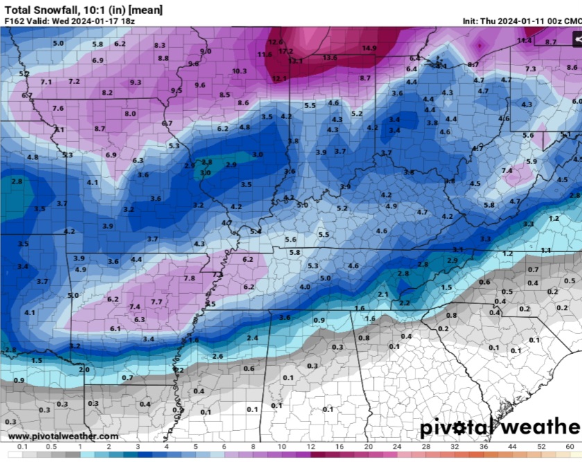
-
January Medium-Long Range Discussion
TellicoWx replied to Holston_River_Rambler's topic in Tennessee Valley
Suppressed mess has been my biggest fear with this system last couple days for us here in the east...hopefully just a hiccup -
January Medium-Long Range Discussion
TellicoWx replied to Holston_River_Rambler's topic in Tennessee Valley
Avoid the 0z GEFS like the plague...hopefully a blip and not a trend..lots of members say "what storm?" -
January Medium-Long Range Discussion
TellicoWx replied to Holston_River_Rambler's topic in Tennessee Valley
I agree, while it can cut some..it's usually way overdone. -
January Medium-Long Range Discussion
TellicoWx replied to Holston_River_Rambler's topic in Tennessee Valley
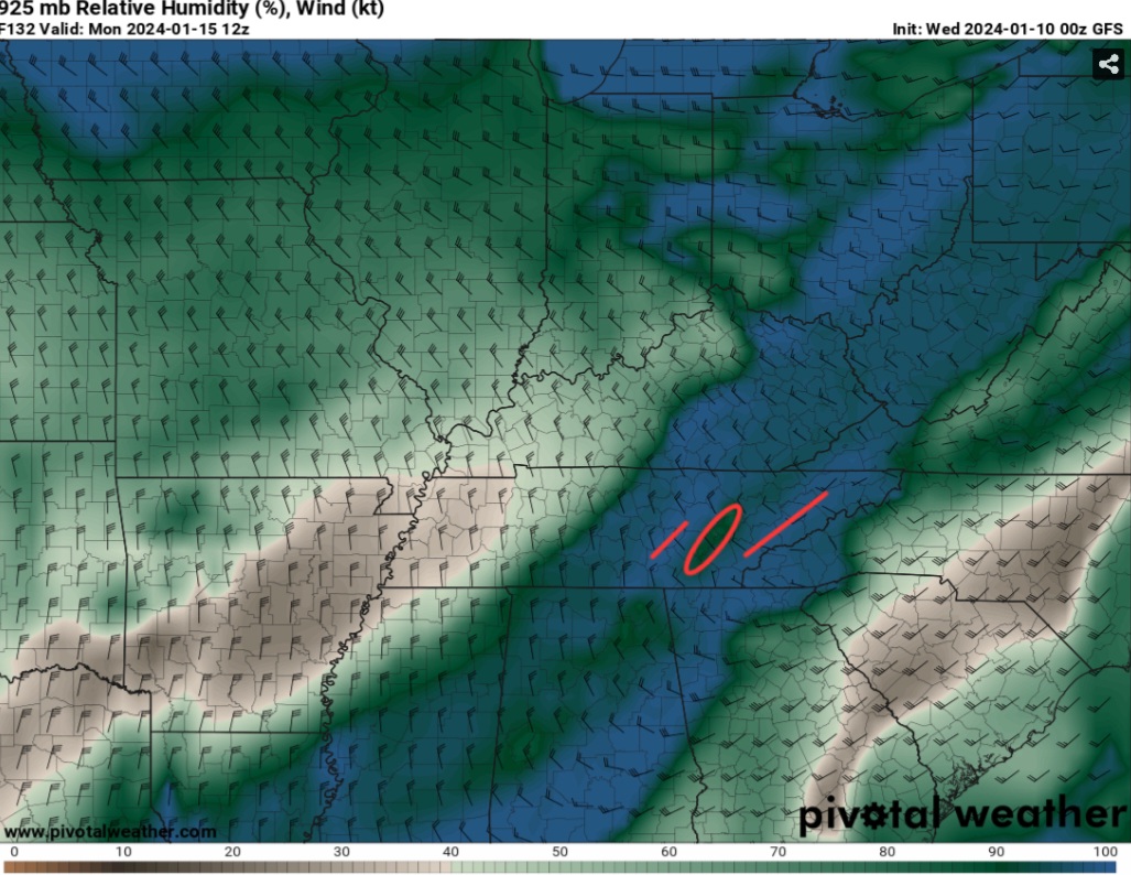
You can see errors in both the GFS and CMC on the 925 at 132hr GFS inexplicably doesn't fill in the Tri hole, even tho the moisture transport/banking is there. While CMC setup would create a hole toward Tri (due South to North wind would create downslope there off the Smokies). Chatt accum doesn't add up due to 0 downslope on it. -
January Medium-Long Range Discussion
TellicoWx replied to Holston_River_Rambler's topic in Tennessee Valley
Almost carbon copy anafrontal setup for the valley. While I don't believe Chatt Dome would be that strong as the accum map shows, it would be less (downslope cuts it). The Tri hole I have 0 belief in. You can see the downslope (Red Circle), as well as the low level moisture getting banked up (Red Lines) on the 925 RH maps
-
January Medium-Long Range Discussion
TellicoWx replied to Holston_River_Rambler's topic in Tennessee Valley
Winds picked back up to 30mph, with moderate snow coming down...almost looks like a mini blizzard outside. If only the temp wasn't 36.... -
January Medium-Long Range Discussion
TellicoWx replied to Holston_River_Rambler's topic in Tennessee Valley
Finally switched over to sloppy flakes here. -
January Medium-Long Range Discussion
TellicoWx replied to Holston_River_Rambler's topic in Tennessee Valley
For those new to the hobby, and not quite familiar with the topo and how it greatly impacts the Great Valley hopefully this will help...(and yes there is some truth to the Cattanooga Snowdome lol). This generally applies to anafrontal and Northwest Snow Flow Events. Surface LP has a ton of other variables. Think of the atmosphere as a liquid with differing viscosity. Warm is less dense and rises, cold undercuts the warm as if it has a thicker viscosity. The Plateau acts like a dam for the denser cold air (Blue Arrows over Middle TN). Just west of Knoxville near Kingston, the Plateau has a natural spillway/funnel that allows as small area for the cold to funnel into the valley (if you watch fronts pass over, you can actually see this occur live on PWS's in the area). There is a much smaller spillway west of Chattanooga, but due to the nature/design of the Plateau, cold must slowly fill the Sequatchie Valley first before trying to continue advancing toward Chattanooga (leaving that area to primarily rely on the Kingston "spillway" to supply it with the cold. As lift generally pulls away from the valley from SW to NE, the column dries the quickest at Chatt. Add in the distance from Kingston to Chatt the slow moving cold air arrives almost too late...hence the Chattanooga Snowdome. Other areas of interest due to topo.. 1) Green Box Areas - as the cold naturally pushes SE, it sometimes can force moisture to pool up in these areas, enhancing snowfall output. This is what occurs 9/10x when East of Hwy 411 ends up with greater totals than west side. 2) Red Boxe Area - The downsloping winds of the Plateau speeds up the drying process further...making the Dome that much stronger. -
January Medium-Long Range Discussion
TellicoWx replied to Holston_River_Rambler's topic in Tennessee Valley
In an anafrontal setup some things that models will not have a grasp of at this ramge: 1) the depth of the shallow low level moisture. This range they have a tendency to sometimes dry the DGZ out to quickly, not picking up on where the moisture banks up against micro climate areas (such as the plateau/foothills etc). 2) Under estimate how far ahead the shallow arctic air has actually advanced during very powerful cold fronts. 3) The exact placement of Vertical Velocities. Becomes more important with anafrontal due to having to rely on the UVVs more for the lift, than have the traditional SLP aided lift. -
January Medium-Long Range Discussion
TellicoWx replied to Holston_River_Rambler's topic in Tennessee Valley
I'm in Madisonville in Monroe Co.. just had quick burst sleet here as well, Temps about same as there -
January Medium-Long Range Discussion
TellicoWx replied to Holston_River_Rambler's topic in Tennessee Valley
Long story short...think suppressed is the ultimate outcome currently -
January Medium-Long Range Discussion
TellicoWx replied to Holston_River_Rambler's topic in Tennessee Valley
To me there is 2 possible outcomes still being figured out and 1 joker card. A) the Hudson Low and 1050+ High dropping down are too far south currently modeled (there placement is what pushes the front thru). Which would mean the Ops are too suppressed. I give that about 40% weight based on this winter of the SE trend, plus climate. B. Those features are too north and Ops too slow with the front = cold rain, which some ensembles show. Think that is more likely currently on most modeling. And Joker Card...whether or not the wave can generate cyclogenisis along the Gulf. Joker can reck havoc on both A) and B...think that will be an issue foe the next several days. -
January Medium-Long Range Discussion
TellicoWx replied to Holston_River_Rambler's topic in Tennessee Valley
2" mean on 6z GEFS now basically extends down to I-40 between Memphis and Nashville now for Fri system -
January Medium-Long Range Discussion
TellicoWx replied to Holston_River_Rambler's topic in Tennessee Valley
Hr 90 on 6z GEFs....0z only had about 1/3 of members bringing the backside into the state. -
January Medium-Long Range Discussion
TellicoWx replied to Holston_River_Rambler's topic in Tennessee Valley
West and Middle TN folks may not wanna sleep on this Fri system..6z GEFS continues trend of inching the mean LP eastward. -
January Medium-Long Range Discussion
TellicoWx replied to Holston_River_Rambler's topic in Tennessee Valley
Yeah, would love to see a sleet map for LA/MS/AL...FZ Rain accum goes all way to Mobile -
January Medium-Long Range Discussion
TellicoWx replied to Holston_River_Rambler's topic in Tennessee Valley
Rain/snow line enters state around hr 135, and exits around 180... -
January Medium-Long Range Discussion
TellicoWx replied to Holston_River_Rambler's topic in Tennessee Valley
If you wanna see how the whole state can get smoked, 6z GFS is how. This thing just crawls across the entire state, overrunning from the Gulf. -
January Medium-Long Range Discussion
TellicoWx replied to Holston_River_Rambler's topic in Tennessee Valley
Starting to get power outages across Southern end of the county. Highest gust so far 56.4 mph on Skyway below Indian Boundary (highest elev weather station in area, 1700') -
January Medium-Long Range Discussion
TellicoWx replied to Holston_River_Rambler's topic in Tennessee Valley
Most weather offices tend to lean on it -
January Medium-Long Range Discussion
TellicoWx replied to Holston_River_Rambler's topic in Tennessee Valley
10:1 -
January Medium-Long Range Discussion
TellicoWx replied to Holston_River_Rambler's topic in Tennessee Valley
00z Euro with a big hitter on 15th-16th timeframe -
January Medium-Long Range Discussion
TellicoWx replied to Holston_River_Rambler's topic in Tennessee Valley
Individual members to tag along with @John1122 post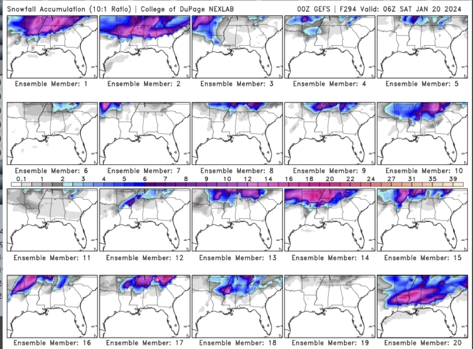
-
January Medium-Long Range Discussion
TellicoWx replied to Holston_River_Rambler's topic in Tennessee Valley
Yeah was just looking at that, as far as individual members it's definitely monsters or nothing. Wherever these tracks setup, looks like will be a winter to remember.