brooklynwx99
-
Posts
5,630 -
Joined
-
Last visited
Content Type
Profiles
Blogs
Forums
American Weather
Media Demo
Store
Gallery
Everything posted by brooklynwx99
-
I'm not expecting much for the E US this year... the strong -PDO and general progression to a more central-based event are certainly mitigating factors. would be surprised if there was AN snow for NYC, certainly DC. Boston could actually have a decent year as they do in Ninas with that being said, this winter does look to begin east-based, which may make December pretty interesting. I'll start digging into some more concrete analogs over the coming month or so
-
speaking of stats, I think part of it is also just crushing regression to the mean. there were many winters with big coastals (2014-15 being the prime example) and I think we're crashing back down to offset those years. CC plays a part, of course, but I think stats are just as big of a factor
-
this has 19-20, not 20-21... summer of 2020 was one of those high ACE years
-
CSU is now forecasting 230 ACE... this is probably one of the only variables that actually looks good for E US winters. otherwise, slim pickings
-
the thing with Nina is that you can have that Aleutian ridge break more poleward and give us legit cold air into Canada. Ninos have no such benefit if we do end up with a more east based event, I’ll be a lot more optimistic, as at least we could see the ridging move over AK. as of now, I’m still expecting a pretty lame winter from NYC south. Ninas can be quite fun for you guys, though. especially up by you
-

2024 Atlantic Hurricane Season
brooklynwx99 replied to Stormchaserchuck1's topic in Tropical Headquarters
haha I mean I am Gen Z. just turned 25 anyway this season does look bad. don't see how this is anything but active. if not hyper -
2024 Atlantic Hurricane Season
brooklynwx99 replied to Stormchaserchuck1's topic in Tropical Headquarters
will beryl rizz up livvy dunne in Ohio? will she mog baby gronk? would be skibidi -
last winter also could have ended much differently if that mid-Feb storm did indeed produce that huge wave breaking -NAO that was advertised by every model at range. easy to forget that as well... that was a complete modeling disaster. probably the worst i've seen
-
2024 Atlantic Hurricane Season
brooklynwx99 replied to Stormchaserchuck1's topic in Tropical Headquarters
holy crap
-
only a matter of time until we see positive regression to the mean. a lot of us forget how prolific the 2000s and 2010s were since we were living through them. the 70s and 80s were way more futile than this stretch NYC had ONE winter over 30" between 1969-70 and 1992-93, which was 1977-78. one! could you imagine now? people would be jumping from rooftops. yes, there were less complete duds and it was colder overall, but I will take the duds if it means more 40"+ winters
-
btw, this absolutely could be a high ACE Atlantic hurricane season. could even be hyperactive. CSU's hurricane forecast is pretty dire
-
the only reason it's even a consideration is because it was a moderate Nina (three trimonthlies of -1.0) that came off of a moderate Nino and it has some similarities in the Atlantic for this summer and autumn. it's not weighted high, and there's no reason why any analog should be completely discounted at this range when it's a similar ENSO state. I don't even expect a snowy winter. it'll probably be AN temps and BN snow for the east also, anyone that's certain about how strong the Nina is going to be and how it'll configure itself is fooling themselves. it isn't even June yet
-
1988-89, 1995-96, 1998-99, 2005-06, 2010-11, 2019-20, and 2020-21 are all fine analogs for now IMO. no real way to know which are better than others at this point given that we don't even know how the Nina is going to evolve at this point for the record, I am not expecting a good winter for the East. however, the two things that can help are a bit of Nino lag (helped in 95-96 and 2010-11 most notably) and high ACE, both of which likely have some kind of impact. we can just as easily see another dud, which is safer to expect the rubber band does have to snap back at some point... positive regression to the mean is pretty much imminent. would be ironic if we do see one of the good Nina winters in a year where people are expecting so little
-
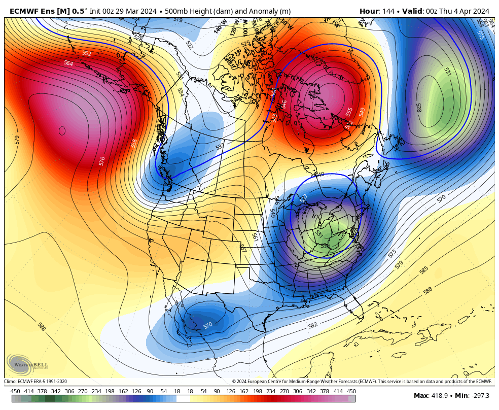
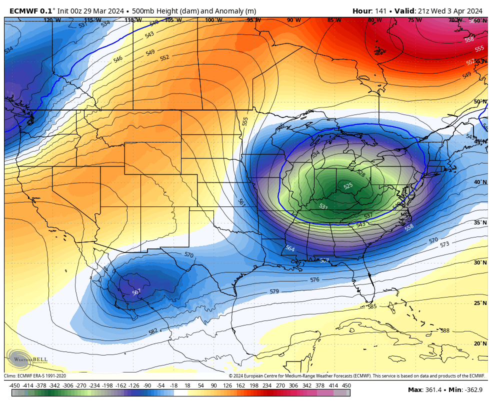
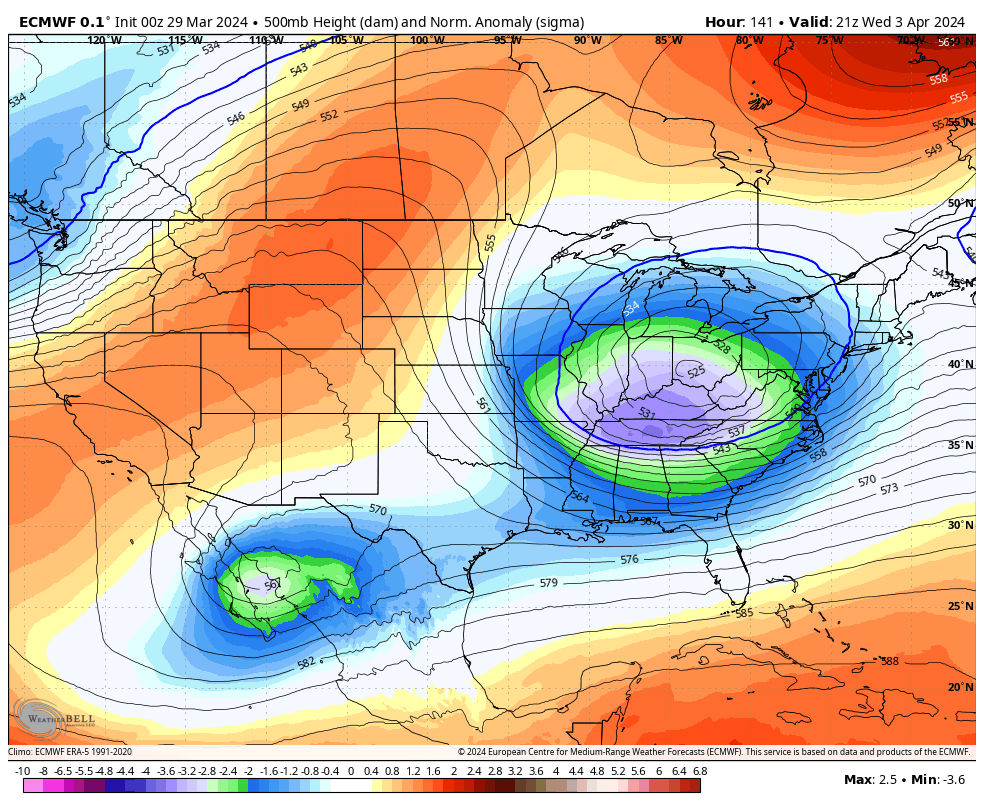
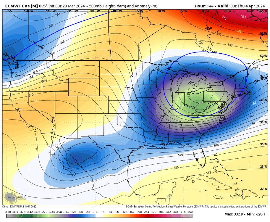
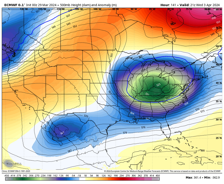
trough on the EPS is deeper with stronger blocking
-
you have an anomalous -NAO breaking down over the Davis Strait and a 50/50 in place, it’s a really good pattern for a significant storm. and the trough is showing up as low as -3 to -4 sigma on OP runs. climo starts to mean less when you’re dealing with that level of deviation from the mean someone is going to get crushed. I would feel a lot better if I was in Boston

-
Significant Miller B Nor'easter watch, Apr 3rd-4th
brooklynwx99 replied to Typhoon Tip's topic in New England
also, lol
-
Significant Miller B Nor'easter watch, Apr 3rd-4th
brooklynwx99 replied to Typhoon Tip's topic in New England
and the trough is showing up as low as -3 to -4 sigma on OP runs. climo starts to mean less when you’re dealing with that level of deviation from the mean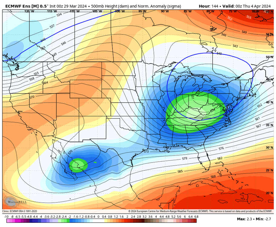

-
Significant Miller B Nor'easter watch, Apr 3rd-4th
brooklynwx99 replied to Typhoon Tip's topic in New England
you have an anomalous -NAO breaking down over the Davis Strait and a 50/50 in place, it’s a really good pattern for a significant storm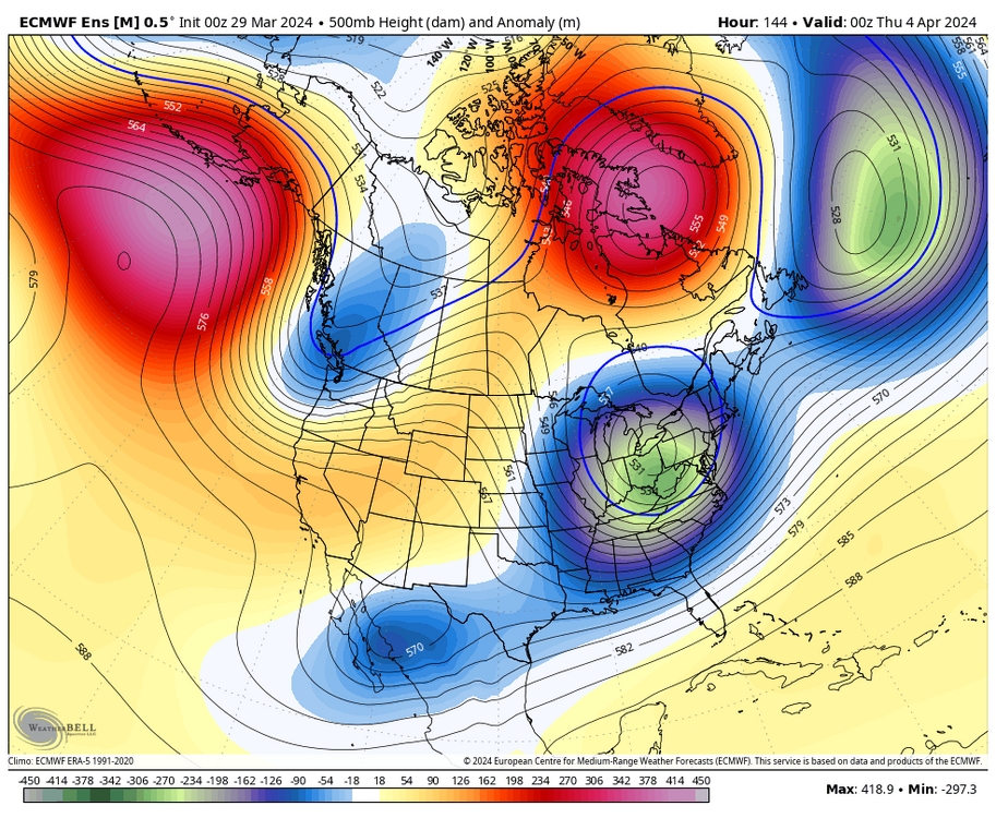
-
verbatim, some pretty stout cross polar flow develops. again, I would like to see it get closer, but it would work

-
IF the TPV gets displaced like some of the OP runs have shown, I'll buy it. big if for now, but with the ongoing SSW and Pacific wave breaking, it is a possibility. would be silly to totally dismiss it
-
hell, even 1998 had a late season event followed by a week of 80s. it was NYC's only snow of the winter
-
IF there were to be a weird late season event, this would be the pattern needed to get it done

-
Late Feb/March Medium/Long Range Discussion
brooklynwx99 replied to WinterWxLuvr's topic in Mid Atlantic
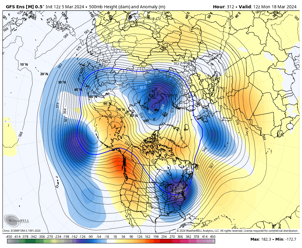
IF there were to be a weird late season event, this would be the pattern needed to get it done

-
lol. if there was to be a dumb late season event, this would be the pattern you’d need to pull it off


-
this ain’t bad… blocked flow to the north, a 50/50 in place, and strong HP to the north to allow colder air to drain in. again, something to keep an eye on, especially away from the immediate coast