brooklynwx99
-
Posts
5,630 -
Joined
-
Last visited
Content Type
Profiles
Blogs
Forums
American Weather
Media Demo
Store
Gallery
Everything posted by brooklynwx99
-

Blowvember - and not named for wind potential
brooklynwx99 replied to Go Kart Mozart's topic in New England
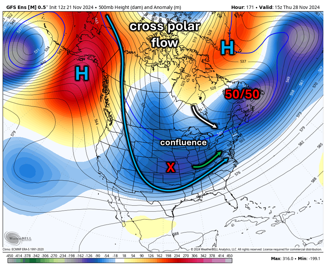
Although it's early in the year, next week's setup is a good one, as there is a potent ridge over AK that's reaching all the way into Siberia, promoting cross polar flow. Perhaps most notably, there is a developing Greenland block that forces a 50/50 ULL (ULL over Nova Scotia, basically). As a vort gets ejected from the Rockies, the confluence from the 50/50 ULL may push colder, drier air into the flow and can prevent the main energy from shooting north. This is more of an overrunning to coastal or SWFE type event rather than a potent Nor'easter, to be clear. This is a favorable setup for snowfall, even down to the Mason-Dixon line. If it was late Dec instead of late Nov, I would be more open to workable coastal snowfall, though that is a difficult ask given how warm waters are. The main points of contention are: 1) how quickly does the vort get ejected? 2) how much of the vort gets ejected? and 3) how strong is the confluence? I would argue that the confluence is the most important part of the setup... if it vanishes, there is not enough press from the cold air and the setup is DOA. However, if the vort comes out too early, it won't matter. This is unlikely, though... if anything, the vort would come out of the Rockies too late or too sheared rather than before confluence forms. How the 50/50 ULL trends is crucial to this setup and I will be watching that closely. These cross polar flow patterns are pretty much the only ones cold enough to allow for snow at this time of year, and there is very high confidence in one developing. We are still at the range where the vort can get sheared to nothing, so the storm can still "disappear." Just don't write the threat off due to the time of year.
-
Although it's early in the year, next week's setup is a good one, as there is a potent ridge over AK that's reaching all the way into Siberia, promoting cross polar flow. Perhaps most notably, there is a developing Greenland block that forces a 50/50 ULL (ULL over Nova Scotia, basically). As a vort gets ejected from the Rockies, the confluence from the 50/50 ULL may push colder, drier air into the flow and can prevent the main energy from shooting north. This is more of an overrunning to coastal or SWFE type event rather than a potent Nor'easter, to be clear. This is a favorable setup for snowfall, even down to the Mason-Dixon line. If it was late Dec instead of late Nov, I would be more open to workable coastal snowfall, though that is a difficult ask given how warm waters are. The main points of contention are: 1) how quickly does the vort get ejected? 2) how much of the vort gets ejected? and 3) how strong is the confluence? I would argue that the confluence is the most important part of the setup... if it vanishes, there is not enough press from the cold air and the setup is DOA. However, if the vort comes out too early, it won't matter. This is unlikely, though... if anything, the vort would come out of the Rockies too late or too sheared rather than before confluence forms. How the 50/50 ULL trends is crucial to this setup and I will be watching that closely. These cross polar flow patterns are pretty much the only ones cold enough to allow for snow at this time of year, and there is very high confidence in one developing. We are still at the range where the vort can get sheared to nothing, so the storm can still "disappear." Just don't write the threat off due to the time of year.

-
Blowvember - and not named for wind potential
brooklynwx99 replied to Go Kart Mozart's topic in New England


-
although it won't magically flip, the Japan trough and equatorward jet will promote LP and cooling from Japan to N of HI, and the AK ridge will promote warming in the GoAK the PDO won't flip this year, but this will almost certainly make a big dent in the magnitude of the negative anomaly
-
Blowvember - and not named for wind potential
brooklynwx99 replied to Go Kart Mozart's topic in New England
the equatorward jet extension keeps an Aleutian trough in place... it actually strengthens as the run goes on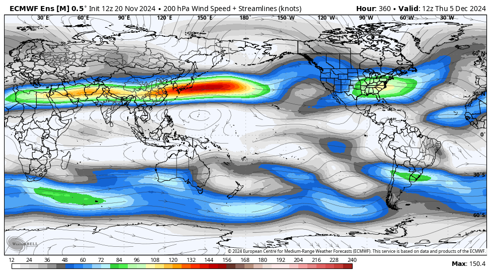
-
I wasn't expecting a cold or snowy winter going into autumn with the -3.5 PDO either, believe me. however, 2013-14 has always been an intriguing year, and often times the late Nov-early Dec pattern will show the flavor of the winter, whether good or bad
-
I guess the "Nino hangover" is a thing after all that also makes me wonder if Feb is really going to be that crappy... if we don't have a super strong Nina influence, is it wise to assume so? for the record, I still expect a warm Feb, I'm just not as confident in it
-
Blowvember - and not named for wind potential
brooklynwx99 replied to Go Kart Mozart's topic in New England
it's looked warm and dry for quite some time. Nov was a very high confidence forecast IMO -
going to be honest, I really did think that early Dec would be quite warm with the state of the MJO, but it clearly isn't driving the bus. my guess is the higher AAM is leading to a more extended jet, pushing the ridge near the Aleutians closer to AK and leading to more poleward wave breaking
-
the PDO isn't really a pattern driver... more of a pattern reinforcer. a -PDO will enhance a -PNA, but the 500mb pattern ultimately drives the SST anomalies, not the other way around
-
at some point, to change the -PDO, there is often a year that has a disconnect and features a +PNA... 2013-14 was that year, and the -PDO is probably going to end up close to neutral if the advertised pattern comes to fruition not to say we're going to get a 2013-14 type year... something like a 2013/2021 mix is likely the colder scenario for the winter
-
models are advertising +AAM with is unusual for -ENSO. wouldn't be shocking considering a top 5 Nino last year
-
Blowvember - and not named for wind potential
brooklynwx99 replied to Go Kart Mozart's topic in New England
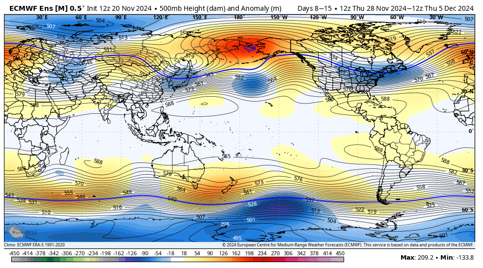
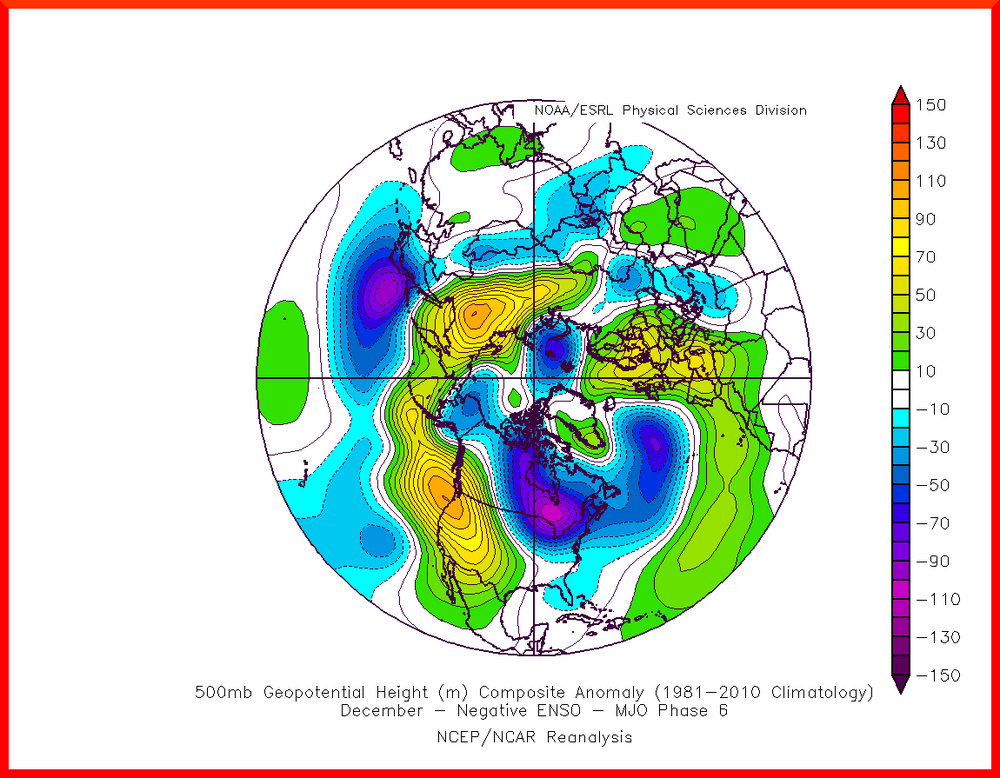
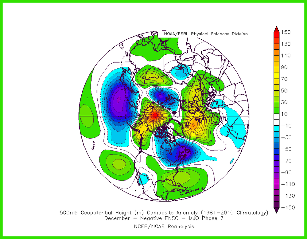
really nice -EPO/-WPO pattern. there's confluence as the TPV elongates in the 50/50 region which would lock in that high verbatim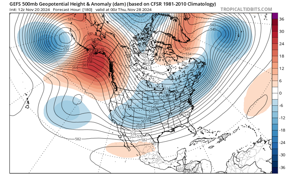
-
been a long time since I've seen a SE ridge get squashed in the medium range

-
been a long time since I've seen a SE ridge get squashed in the medium range
- 411 replies
-
- 19
-

-

-
been a long time since I've seen a SE ridge get squashed in the medium range

-
2013-14 has been a good analog for a while. high solar, too
-
agreed with 3-5, but 6 and 7 are warm. the MJO isn't a silver bullet... there could be other factors at play. I also thought that models would trend warmer in the late Nov - early Dec period, but that does not appear to be the case. CPC likely busts warm on their forecast for early Dec
-
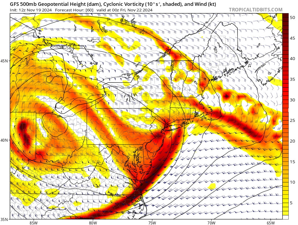
RGEM is advertising a highly anomalous ~522dm ULL E of LI... would bring heavy snow to NNJ verbatim even with marginal surface temps this is about as dynamic of a setup as you'll see regardless of the time of year
.thumb.png.a5b4b8990740bb4fc56f0931dae4e794.png)
-
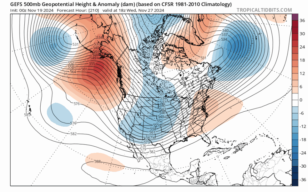
really good agreement on all ensembles for a -EPO/-WPO pattern to form with cross polar flow. want to see this get inside the D5-7 range, though it is encouraging

-
really good agreement on all ensembles for a -EPO/-WPO pattern to form with cross polar flow. want to see this get inside the D5-7 range, though it is encouraging

-
Blowvember - and not named for wind potential
brooklynwx99 replied to Go Kart Mozart's topic in New England
really good agreement on all ensembles for a -EPO/-WPO pattern to form with cross polar flow. want to see this get inside the D5-7 range, though it is encouraging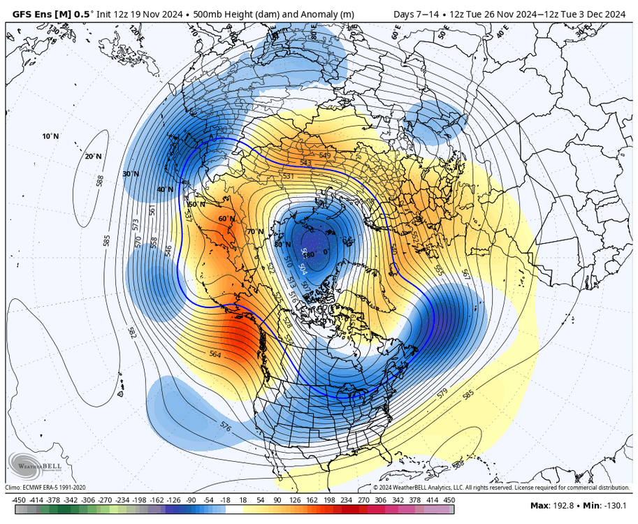
-
Blowvember - and not named for wind potential
brooklynwx99 replied to Go Kart Mozart's topic in New England
not saying that this is the year (it probably isn't), but with CC, you're going to get more crap winters than normal. however, when you do get a good winter, it's probably going to break records in places. you just have more moisture to work with. 2013-14 or 2014-15 with more oomph can cancel out the last 3-5 years of boredom -
this is a bit different than typical wraparound moisture
-
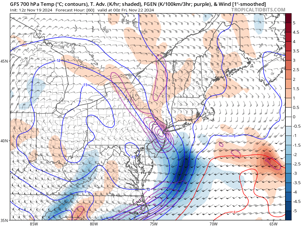
very dynamic solutions showing up for NNJ and parts of the HV. very good FGEN and lift BL is going to be an issue this early in the year but heavy rates and post sundown timing really increase the odds for accums. hills are going to be favored in these early season situations, though it's best not to mess around with setups as dynamic as these
.thumb.png.c2d4a53e38708f867a41a8f0ee653ca1.png)


.png.00237e00b9c09aa87cebf5c1fc939aaa.png)


.png.104bbac926118951197de82158183732.png)