

brooklynwx99
-
Posts
5,630 -
Joined
-
Last visited
Content Type
Profiles
Blogs
Forums
American Weather
Media Demo
Store
Gallery
Everything posted by brooklynwx99
-
 UKMET is an absolute ripper
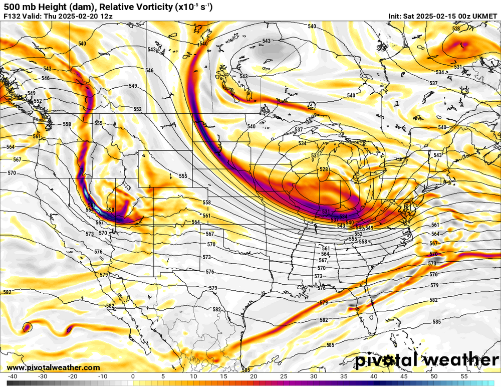
-
GEFS is slower with more tucked members
-
GEFS is also slower with more tucked members
-
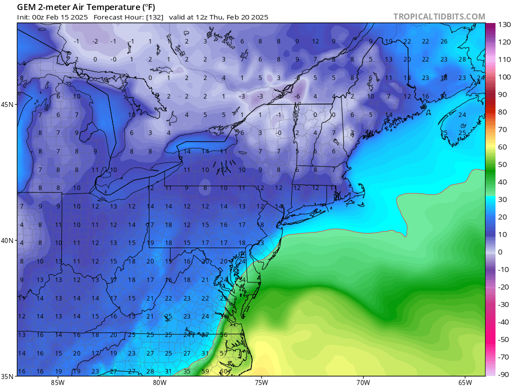
it's in the single digits before the low arrives. the antecedent airmass is pristine

-
lol what?

-
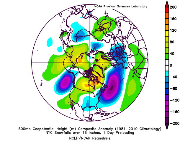
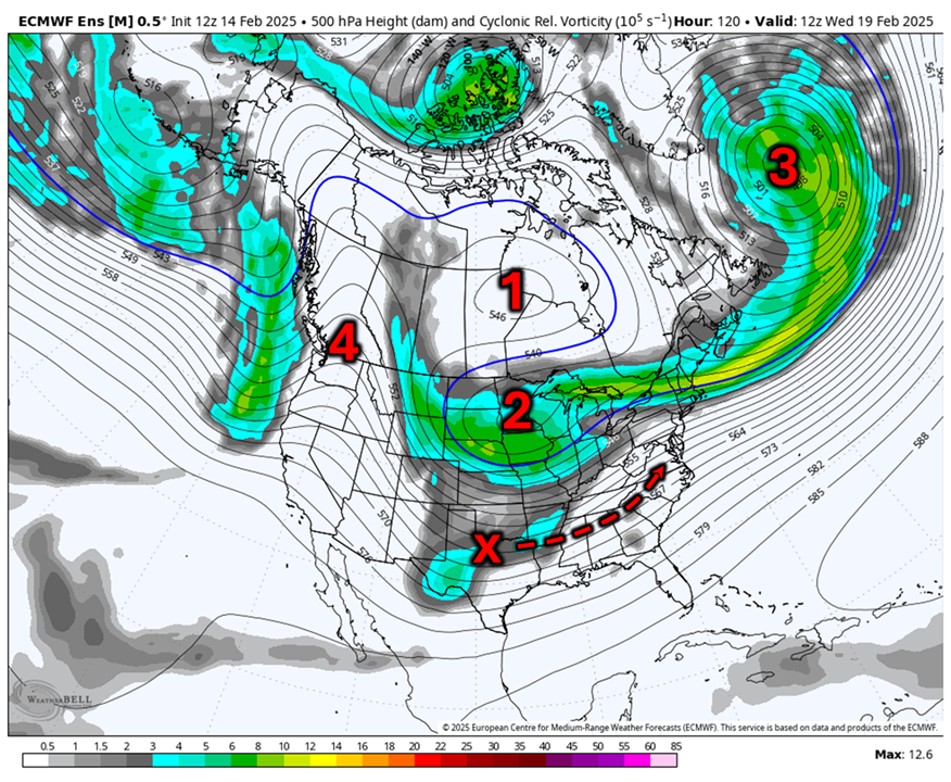
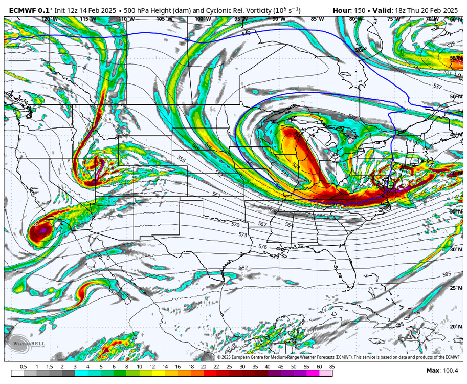
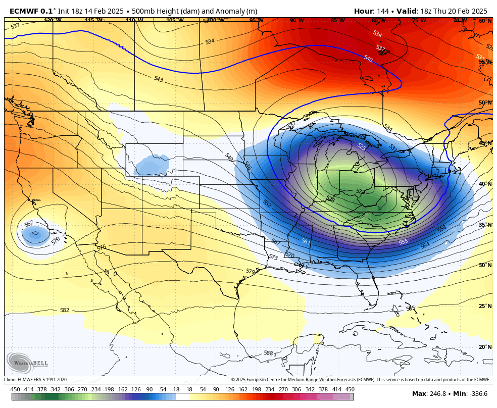
Next week's system has become increasingly ominous and holds potential for significant to major impacts from DC - NYC and even BOS. There are a few features that make this such a favorable setup, mirroring past major and even historic storms: The most important feature of this setup is the retrograding and decaying west-based -NAO that migrates into central Canada. This is perhaps the most important feature for major EC snowstorms, and it is a huge factor here, as it slows the pattern down and locks in confluence. It also leads to the "banana" HP that often develops in these setups due to NVA downstream of the block. This is a lobe of the polar vortex (PV) that is the impetus for the storm threat. This lobe becomes trapped under the block and will be forced to pivot under it, leading to a potential phase with the southern stream vort (x) over TX/OK. This kind of slow-moving, amplified ULL is also a main feature of major storm threats. As is common in these setups, a disturbance, either coastal or otherwise, amplifies into the northern Atlantic and becomes trapped by the block, leading to a 50/50 ULL that departs. This is crucial for establishing confluence, which keeps heights in check downstream of the amplifying trough. Note how heights are zonal over ME and Atlantic Canada. Last but not least, there is a transient spike in heights over the Pacific NW that links up with the blocking. This is a crucial piece of the puzzle... if that disturbance offshore destructively interferes with the blossoming +PNA, you get a weaker solution. However, the trend has been for constructive interference, which helps lead to downstream amplification. It's also worth noting that this setup very closely mirrors past setups that delivered historic snowfall to the northern Mid-Atlantic. Notice the 500mb composite that has all four main features... the retrograding and decaying block, the amplifying trough over the MS River Valley, departing confluence, and a brief PNA spike as the storm is getting its act together. Suffice it to say, this is probably the best synoptic setup that we have seen enter the medium range since February 2021 and it does hold the potential to be just as impactful. The GFS not being on board is pretty common in these setups. However, we will want to see this amplification signal enter the 96 hour window, so if we see this signal last into Monday, talks about a legitimate major snowstorm will hold more weight. Right now, it's worth being cautious, but the pattern has been screaming this kind of outcome for a week now, and it is bolstered by past outcomes.

-
Next week's system has become increasingly ominous and holds potential for significant to major impacts from DC - NYC and even BOS. There are a few features that make this such a favorable setup, mirroring past major and even historic storms: The most important feature of this setup is the retrograding and decaying west-based -NAO that migrates into central Canada. This is perhaps the most important feature for major EC snowstorms, and it is a huge factor here, as it slows the pattern down and locks in confluence. It also leads to the "banana" HP that often develops in these setups due to NVA downstream of the block. This is a lobe of the polar vortex (PV) that is the impetus for the storm threat. This lobe becomes trapped under the block and will be forced to pivot under it, leading to a potential phase with the southern stream vort (x) over TX/OK. This kind of slow-moving, amplified ULL is also a main feature of major storm threats. As is common in these setups, a disturbance, either coastal or otherwise, amplifies into the northern Atlantic and becomes trapped by the block, leading to a 50/50 ULL that departs. This is crucial for establishing confluence, which keeps heights in check downstream of the amplifying trough. Note how heights are zonal over ME and Atlantic Canada. Last but not least, there is a transient spike in heights over the Pacific NW that links up with the blocking. This is a crucial piece of the puzzle... if that disturbance offshore destructively interferes with the blossoming +PNA, you get a weaker solution. However, the trend has been for constructive interference, which helps lead to downstream amplification. It's also worth noting that this setup very closely mirrors past setups that delivered historic snowfall to the northern Mid-Atlantic. Yes, it's for NYC, but you guys generally want the same pattern, and there is a lot of overlap between HECS for NYC and BWI/DC. Notice the 500mb composite that has all four main features... the retrograding and decaying block, the amplifying trough over the MS River Valley, departing confluence, and a brief PNA spike as the storm is getting its act together. Suffice it to say, this is probably the best synoptic setup that we have seen enter the medium range since February 2021 (I'd run that one back down there if I were you guys) and it does hold the potential to be just as impactful. The GFS not being on board is pretty common in these setups. However, we will want to see this amplification signal enter the 96 hour window, so if we see this signal last into Monday, talks about a legitimate major snowstorm will hold more weight. Right now, it's worth being cautious, but the pattern has been screaming this kind of outcome for a week now, and it is bolstered by past outcomes.

-
EPS is gorgeous. ULL is even more amped than 00z
.thumb.png.06060ca61dd7bfa4a30299e5bebcb0f5.png)
-
yeah. I will say that this kind of retrograding block setup is better for SNE than farther north. rather be in HFD than CON, that's for sure
-
in the grand scheme of things, at this range, I would much rather see this solution than washed out crap like the GFS
-
this entire evolution is right out of the KU handbook

-
this entire evolution is right out of the KU handbook

-
ECMWF is a tucked nuke. HECS verbatim
-
what was that about the GFS again?
-
yup. thing of beauty. can kinda toss the GFS for this suite IMO
-
ECMWF is a monster. captured

-
CMC is actually more amped than 00z lmao. blizzard verbatim
-
i’ve noticed that the AIFS can be just as wrong as other models but its shifts are just less violent for example, it can still move 100-200 miles in a few days, it’ll just do it in small, consistent increments rather than two big jumps
-
probably some of both, mostly some too far east. however, that is an extremely aggressive mean at this range
-
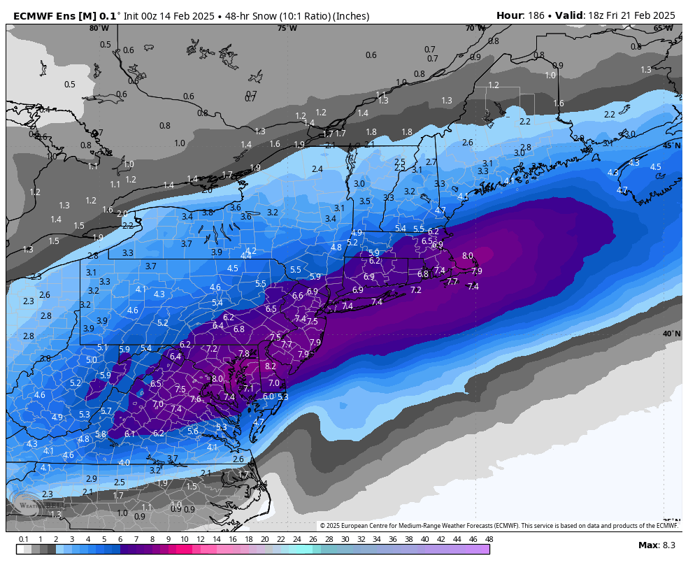
EPS with a 6-8” mean for NYC

-
the ensemble support and general pattern favorability is what makes this so exciting IMO
-
EPS is even better than 12z
.thumb.png.5f31a84d79546f77c68207819de4fa93.png)
-
EPS is insane. better than 12z
.thumb.png.13360fe4a6229012600f43a543389797.png)


.png.a281c78934f792c56fa91cfb980a50f6.png)


.png.e6a05c2ae1bfd662e103c6370390cd6a.png)
.png.c60a79e60de84e63ff039e4b7edc3295.png)