brooklynwx99
-
Posts
6,233 -
Joined
-
Last visited
Content Type
Profiles
Blogs
Forums
American Weather
Media Demo
Store
Gallery
Everything posted by brooklynwx99
-
if you retro that Pacific trough a bit more and allow for the ridge axis over the Plain to shift 100mi towards Montana, things become very interesting
-

December 2025 regional war/obs/disco thread
brooklynwx99 replied to Torch Tiger's topic in New England
the 23rd and 26th are both pretty interesting as vorts come over the top of that C US ridge. could be some WAA thumps -
pretty significant block showing up later in the month, but the Pacific is kinda trash need to see if the block can become more west based and exert its will on the pattern, perhaps a forcing more of a ridge bridge up top. either that, or the Bering Sea ridge nudging east into AK regardless, nice to see an Atlantic block develop... just need to see some other factors become more favorable for legit shots at snow south of the M/D line

-
December 2025 regional war/obs/disco thread
brooklynwx99 replied to Torch Tiger's topic in New England
nah i can't, which is why I think things are going to be one or the other. either more of a trough over the NE or warmer like the old GEPS runs. that's a weird in between -
December 2025 regional war/obs/disco thread
brooklynwx99 replied to Torch Tiger's topic in New England
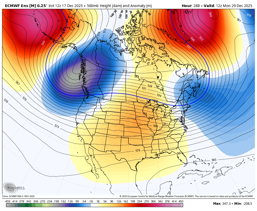
these are also means that we're looking at... it wouldn't be shocking that there's some washing out ongoing for example. members that don't develop a strong -NAO are likely complete torches with very high E US heights. however, ones that do, and especially the ones that shift the block more west, might actually just have a cold airmass in the east. wish there was a way to look at EPS members like that -
December 2025 regional war/obs/disco thread
brooklynwx99 replied to Torch Tiger's topic in New England
story of the last few years. one would have to hope that: 1) the Bering Sea ridge ticks east more into AK so you can get a bit of a ridge bridge going, or 2) the -NAO becomes stronger and more west based, shifting that ridge west along with it (also allowing for more of a ridge bridge) we have also seen models consistently overdo E US heights, so it wouldn't be shocking to see a trough trend deeper as we head closer. we'll see -
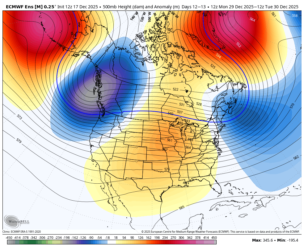
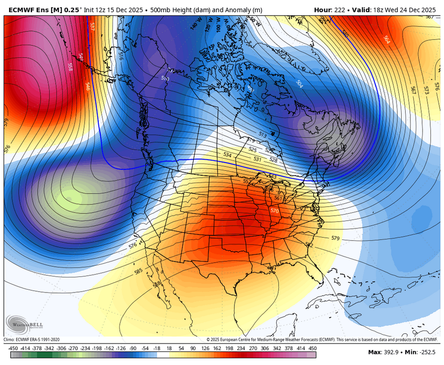
that -NAO has grown rather significant to end to the month... can see a redeveloper around the 28th or so with lower heights being forced over the NE. hopefully we can trend it stronger and farther west

-
December 2025 regional war/obs/disco thread
brooklynwx99 replied to Torch Tiger's topic in New England
that -NAO has grown rather significant to end to the month... can see a redeveloper around the 28th or so with lower heights being forced over the NE. hopefully we can trend it stronger and farther west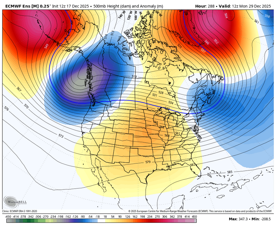
-
ehh, 2016 was not luck. there was a very strong west-based -NAO that developed, which is a classic KU signal
-
sir, this is a La Nina
-
2025-2026 ENSO
brooklynwx99 replied to 40/70 Benchmark's topic in Weather Forecasting and Discussion
yeah, i'm pretty confident that we're going to see the NAO drop rather significantly as the Scandi / N ATL trough retrogrades... the WH MJO forcing is a strong precursor to that, as it helps wavebreaking occur in the N ATL -
December 2025 regional war/obs/disco thread
brooklynwx99 replied to Torch Tiger's topic in New England
EPS is pretty active after the 22nd or so... there will be chances but it's shut the blinds for the next week -
December 2025 regional war/obs/disco thread
brooklynwx99 replied to Torch Tiger's topic in New England
luckily we don't live at 500mb and there can easily be a CAD setup around Christmas with the NW-SE oriented TPV providing confluence
-
this looks like more than a minor snowfall for most of the metro, honestly. solid WAA with warning criteria likely even being approached in CNJ and parts of LI
-
that configuration with low heights diving into the N ATL like that from SE Canada is pretty typical of retrograding -NAO events. would line up well with the lag from the SSW we had in late Nov @Stormchaserchuck1
-
2025-2026 ENSO
brooklynwx99 replied to 40/70 Benchmark's topic in Weather Forecasting and Discussion
wouldn't be surprising in the slightest if this was partially due to the persistent SPV disruptions and SSW that we've seen over the last three weeks. ensembles are definitely picking up on a wavebreaking -NAO signal with some retrograding Scandi / N ATL high pressure -
December 14th - Snow showers or Plowable snow?
brooklynwx99 replied to Sey-Mour Snow's topic in New England
EPS has really been buckling the trough more in recent runs
-
definitely seeing a solid trend towards more buckling of the trough, leading to a bump north with precip. i'm thinking that NYC's looking at 2-4"... might honestly be more like 3-6" at this rate. we'll see if these trends persist. if so, we're looking at more of the latter range

-
December 2025 regional war/obs/disco thread
brooklynwx99 replied to Torch Tiger's topic in New England
merry torchmas!!!
-
2025-2026 ENSO
brooklynwx99 replied to 40/70 Benchmark's topic in Weather Forecasting and Discussion
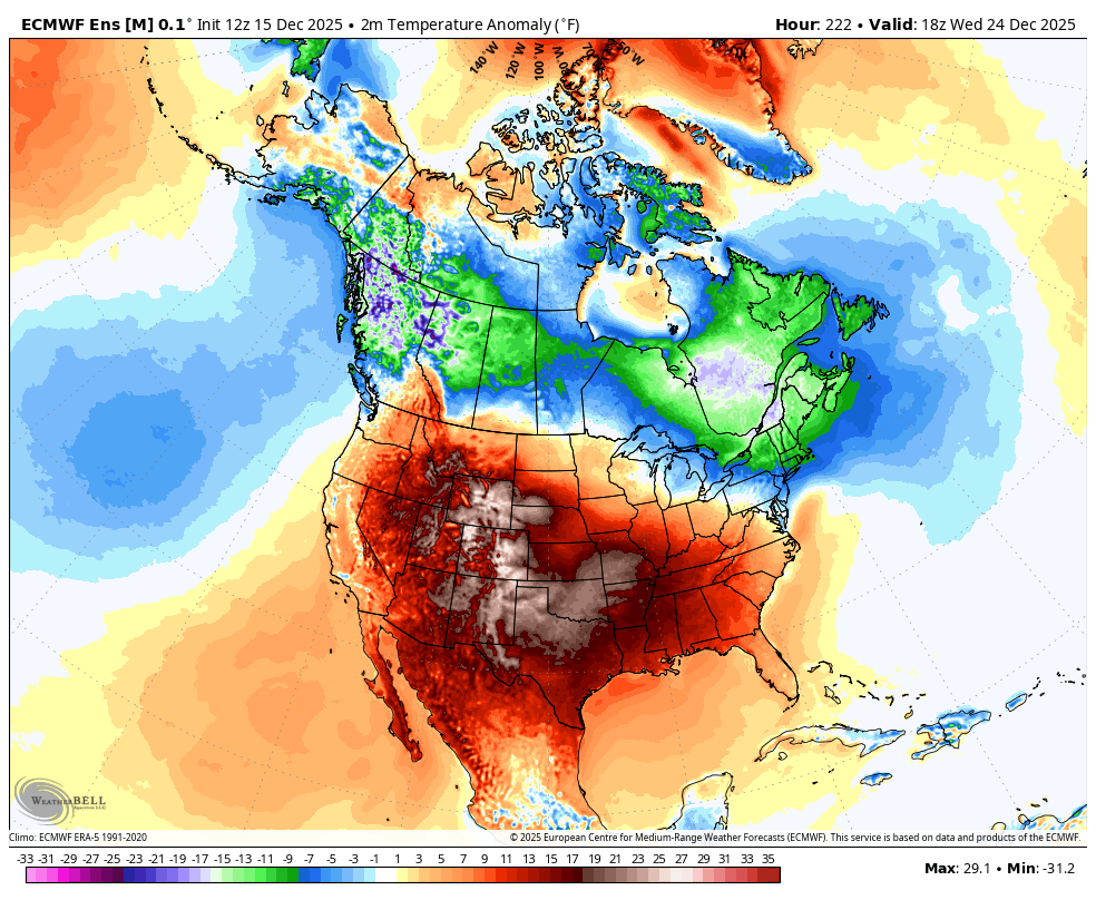
the EPS shows this colder wedging pretty well. might be a bit overdone, but I doubt really torches from NYC north. hell, New England can even see some mixed systems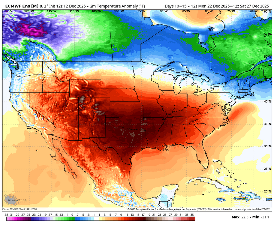
-
2025-2026 ENSO
brooklynwx99 replied to 40/70 Benchmark's topic in Weather Forecasting and Discussion
last time I checked, though, most people don't life 5000 feet above the surface, let alone 15000 feet. if it's NN to BN at the surface in the NE at times, nobody will care if it's +20F over some barren cornfield in NE -
December 2025 regional war/obs/disco thread
brooklynwx99 replied to Torch Tiger's topic in New England
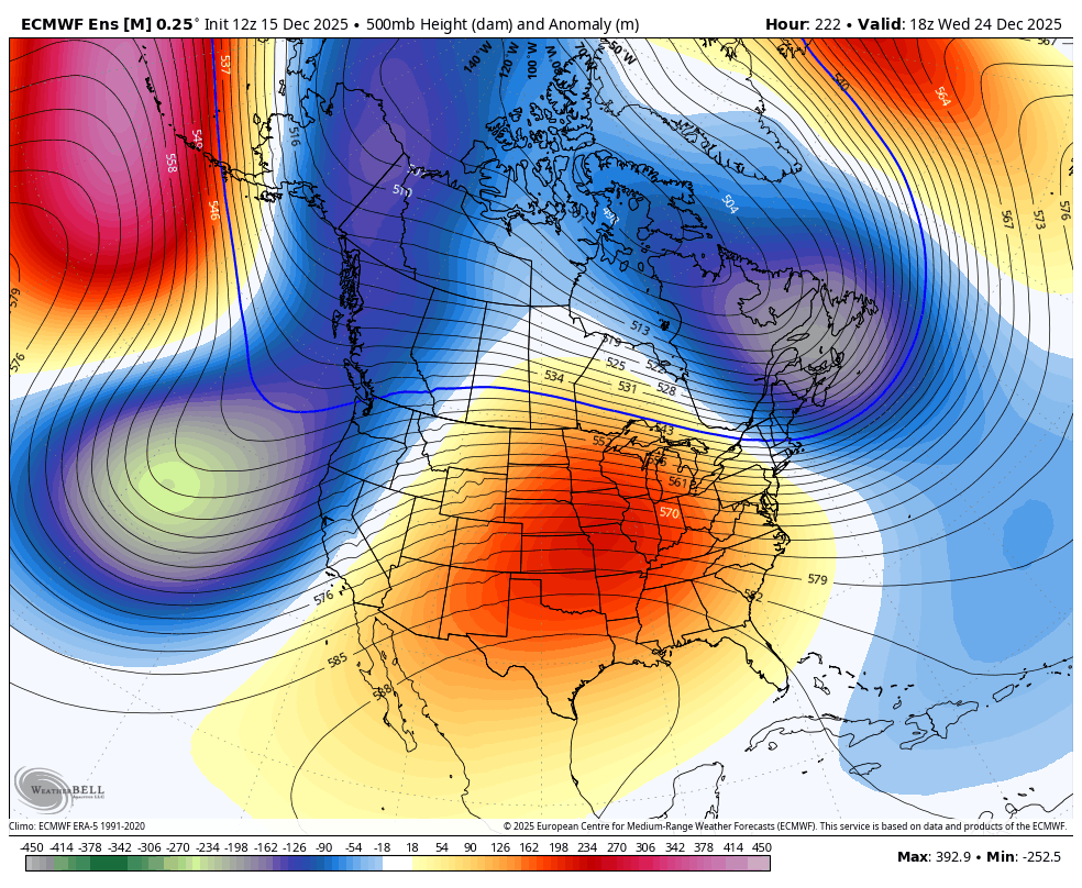
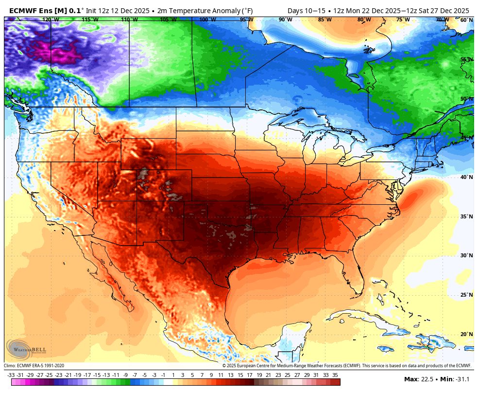
yeah, not really a torch pattern with the -WPO encroaching into AK and the TPV elongated like that. sure, it's a torch for 75% of the CONUS, but who cares -
2025-2026 ENSO
brooklynwx99 replied to 40/70 Benchmark's topic in Weather Forecasting and Discussion
you know, some of you keep giving that guy a platform by breathlessly posting about him. we know he sucks -
the GFS just has to be tossed assuming the ECMWF holds steady. it is awful with these anafront type systems and is almost always too progressive with them we’re still on track for plowable snowfall in the metro IMO
-
2025-2026 ENSO
brooklynwx99 replied to 40/70 Benchmark's topic in Weather Forecasting and Discussion
lol Webb going on his weenie crusade when he hypes just as much as literally everyone else on that platform