-
Posts
7,869 -
Joined
-
Last visited
Content Type
Profiles
Blogs
Forums
American Weather
Media Demo
Store
Gallery
Everything posted by baroclinic_instability
-
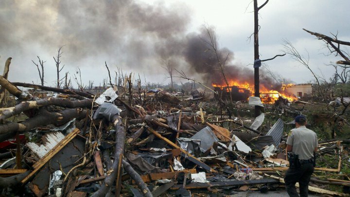
Birmingham, AL's disco this morning. I could not imagine having to write it. WOW...WHAT A DAY. MANY THOUGHTS AND PRAYERS GO OUT TO THOSE IMPACTED BY WEDNESDAYS HISTORIC TORNADIC OUTBREAK ACROSS THE STATE. TRYING TO WRITE A DISCUSSION AFTER SUCH AN ACTIVE DAY IS QUITE DIFFICULT. HOWEVER THE WEATHER NEVER ENDS AND WE MUST CONTINUE. THE NEXT FEW DAYS WILL BE CLEAR...SO THE CLEAN-UP PROCESS CAN BEGIN ACROSS THE STATE. WE ARE GOING TO GO FROM WELL ABOVE NORMALTEMPERATURES OVER THE PAST FEW DAYS TO ACTUALLY BELOW NORMALTEMPERATURES FOR TODAY AS THE COLD FRONT CONTINUES TO PUSH EAST OFTHE AREA. THERE WILL BE SOME MODERATION IN TEMPERATURES THROUGHSATURDAY.THE NEXT WEATHER WILL BEGIN TO MOVE IN ON SUNDAY AS THE NEXT COLDFRONT APPROACHES FROM THE NORTH. MODELS ARE VERY FAR APART INREGARDS TO THIS TIME-FRAME SO THERE IS QUITE A BIT OF UNCERTAINTYTO SAY THE LEAST. THE EURO BLAST THE FRONT THROUGH THE AREA BYMONDAY...WHILE THE GFS HOLDS THE FRONT UP AND BRINGS US SEVERALBANDS OF SHOWERS AND THUNDERSTORMS THROUGH TUESDAY. LOOKING BACKAT PREVIOUS DAYS ABOUT THE ONLY CONSISTENCY BETWEEN MODELS IS THEFACT THAT THEY CONTINUE TO DISAGREE. HOPEFULLY WE CAN GET SOMECONSISTENCY IN HERE WITHIN THE NEXT DAY OR SO. ONE THING TONOTE...IF THE GFS PANS OUT WE COULD SEE A ROUND OR TWO OF STRONGTO MAYBE EVEN SEVERE STORMS...BUT THE INCONSISTENCIES IN THEMODELS ARE JUST TOO LARGE TO INCLUDE AT THIS TIME.
-
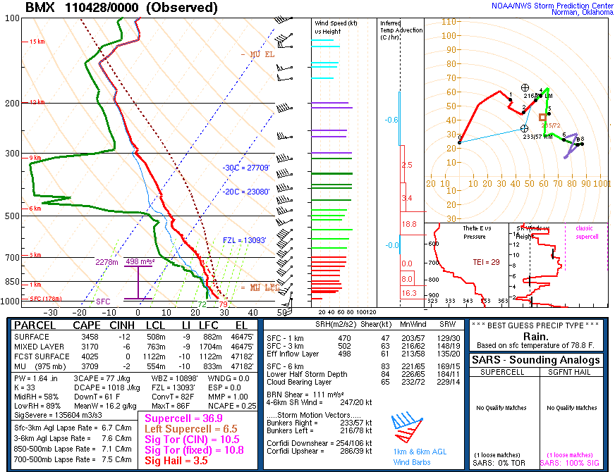
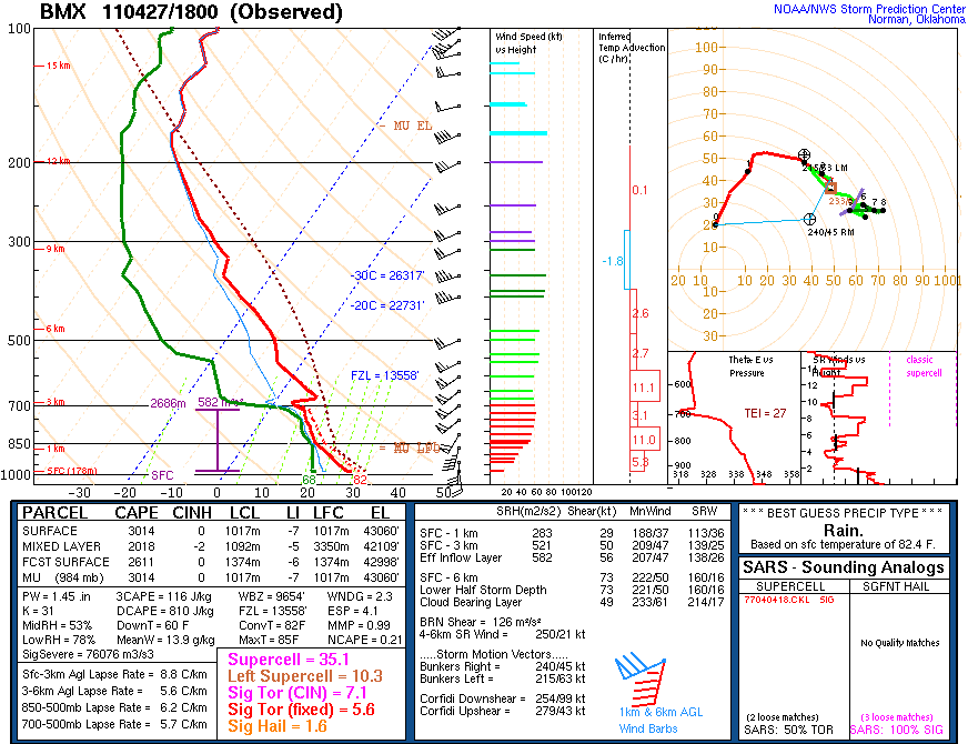
An MCD I will never forget just as this was getting going. MESOSCALE DISCUSSION 0629 NWS STORM PREDICTION CENTER NORMAN OK 0256 PM CDT WED APR 27 2011 AREAS AFFECTED...MUCH OF MS/AL INTO SOUTHERN TN AND NORTHWEST GA CONCERNING...TORNADO WATCH 232...235... VALID 271956Z - 272200Z THE SEVERE WEATHER THREAT FOR TORNADO WATCH 232...235...CONTINUES. PARTICULARLY DANGEROUS SITUATION /PDS/ TORNADO WATCHES 232/235 CONTINUE UNTIL 00Z/03Z RESPECTIVELY. THIS INCLUDES THE POTENTIAL FOR LONG-TRACK STRONG/PERHAPS VIOLENT TORNADOES INTO THIS EVENING AS A SEVERE WEATHER OUTBREAK ONLY INCREASES IN MAGNITUDE/RISK. AN EXTREMELY DANGEROUS/LIFE-THREATENING SITUATION CONTINUES TO UNFOLD THIS AFTERNOON ACROSS A LARGE PART OF MS/AL...WITH ADJACENT PORTIONS OF TN/NORTHWEST GA ALSO EXPECTED TO BECOME A CONCERN LATE THIS AFTERNOON/EVENING. CURRENT OBSERVATIONAL TRENDS...REASONABLY SUPPORTED BY EXPERIMENTAL HRRR GUIDANCE...IMPLY THAT SCATTERED SUPERCELLS WILL CONTINUE TO FORM IN BROKEN NNE-SSW ORIENTED CORRIDORS OF SUBTLE CONFLUENCE AHEAD /EAST/ OF MORE STORMS/SUPERCELLS THAT ARE DEVELOPING ALONG A PRE-COLD FRONTAL TROUGH/DRYLINE GENERALLY NEARING I-55 IN MS. THE WARM SECTOR AIRMASS HAS AGGRESSIVELY DESTABILIZED THIS AFTERNOON AMID NEAR 70F/LOWER 70S F SURFACE DEWPOINTS...REFERENCE SPECIAL 18Z OBSERVED RAOBS FROM JACKSON MS/BIRMINGHAM AL...WITH A WIDE/HIGHLY SHEARED MOIST SECTOR IN PLACE ALONG/SOUTH OF A MODIFYING WEST-EAST OUTFLOW BOUNDARY /NOW AN EFFECTIVE WARM FRONT/ ACROSS FAR NORTHERN PORTIONS OF AL/MS. EXTREME LOW LEVEL SHEAR...VIA LONG/CURVING LOW LEVEL HODOGRAPHS...WILL REMAIN HIGHLY CONDUCIVE FOR SUPERCELLS CAPABLE OF LONG-TRACK STRONG/VIOLENT TORNADOES INTO THIS EVENING AMID 0-1 KM SRH OF 300-500 M2/S2 OR GREATER /ESPECIALLY NEAR THE AFOREMENTIONED NORTHERN MS AND AL BOUNDARY/. ..GUYER.. 04/27/2011
-
Good discussion thewxmann, CUmet, Fred, tornadotony, etc. Going to be an interesting forecast for tomorrow no doubt. I don't think large convective cold pools will be a large worry by the afternoon in this flow regime and the strength of the low level theta-e inflow. The bigger questions, imo, seem to be on the synoptic scale flow and the way the models handle the upper pv anomaly and how it ejects north tomorrow afternoon and evening and the associated upper level jet configuration and associated mesoscale circulations/low level mass response (and subsequent hodograph curvature). I wouldn't be surprised if SPC holds on a high until tomorrow when some of the synoptic and subsequent mesoscale forcing details are better known. That said--seems that a high risk will be highly possible over portions of TN and northern AL at some juncture.


