USCG RS
-
Posts
2,799 -
Joined
-
Last visited
Content Type
Profiles
Blogs
Forums
American Weather
Media Demo
Store
Gallery
Everything posted by USCG RS
-
You can toggle through imagery here: https://www.star.nesdis.noaa.gov/GOES/conus_band.php?sat=G16&band=GEOCOLOR&length=24&dim=1 Edit: @wthrmn654 links are better.
-
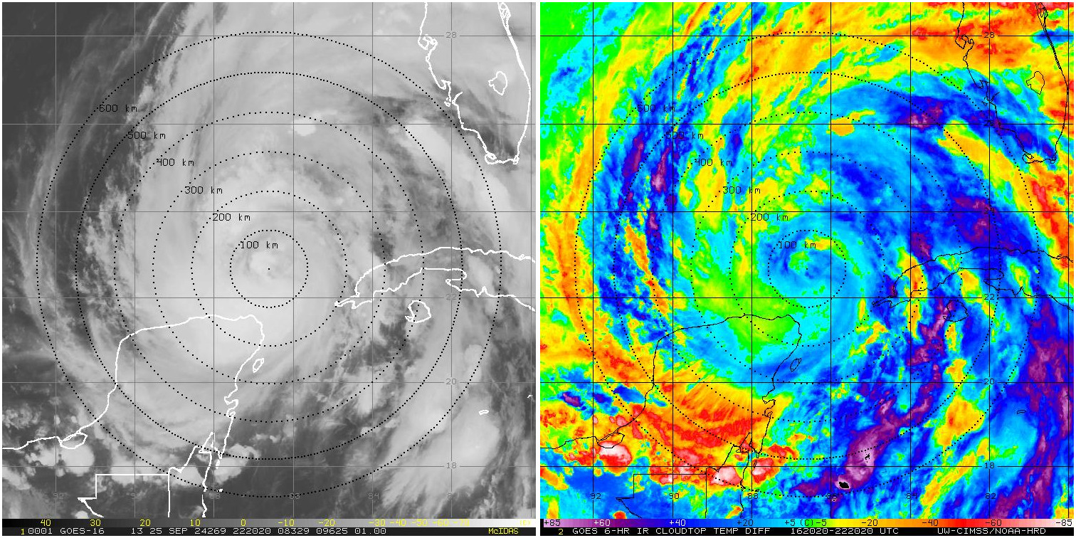
It may not be a ERC so much as the actual structuring of the eyewall finally coming together. Likewise, following ERCs (or the structuring finally being put together), hurricanes tend to take off. When these types of double bands develop and collapse to one, it tends to be a sign of health. Given the environment otherwise, it could be a rather ominous sign.
-
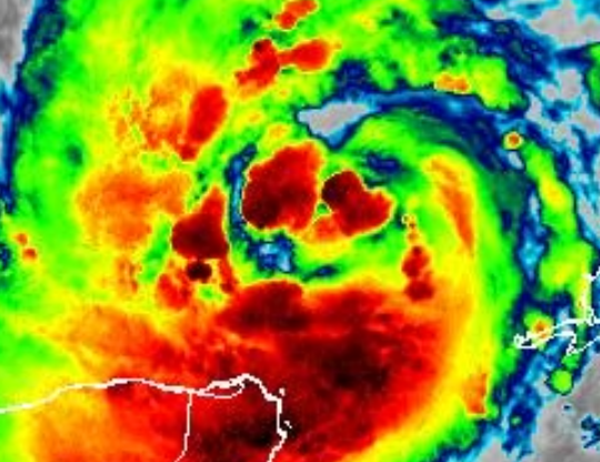
Based on this Satellite Picture, I would say that it is possible that these are Hot Towers showing up. That witsthanding, I would say they are not all that clearly defined as of yet, assuming they are. These hot towers, however, tend to indicate RI is beginning when observed. This is a pretty good and informative video on it: https://www.google.com/search?q=how+to+see+a+hot+tower+in+a+hurricane&oq=how+to+see+a+hot+tower+in+a+hurricane+&gs_lcrp=EgZjaHJvbWUyCQgAEEUYORigATIHCAEQIRigATIHCAIQIRigATIHCAMQIRigATIHCAQQIRigATIHCAUQIRirAjIHCAYQIRirAjIHCAcQIRirAtIBCDQ1MjZqMGo3qAIAsAIA&sourceid=chrome&ie=UTF-8#fpstate=ive&vld=cid:d8125e6a,vid:8U5puPnqMNo,st:0
-
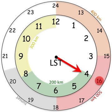
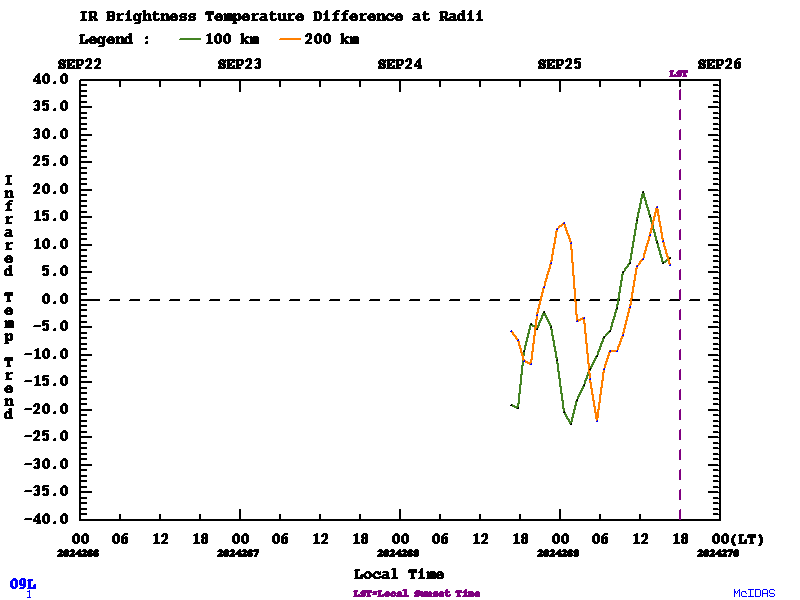
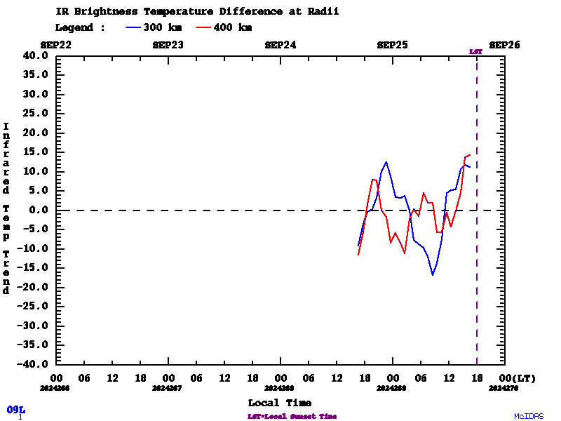
https://tropic.ssec.wisc.edu/real-time/tc_diurnal_cycle/tc_diurnal_cycle.storm.php?&period=3day&prod=&storm=09L This is pretty cool. Did some digging and found a paper on it. This is an expirament currently being run. Scientists have noticed that in the evening (at about sunset) a cold ring of high altitude clouds which propogate outwards overnight. There is a question as to how it affects the intesity of the Cyclone with a hyopthesis that these may indicate gravity waves as well as enhanced outflow in a particular layer of the Troposphere. It appears that this is just a coordination with aircraft hunters currently and a phenemenon which has been observed but as of yet, unknown as to why it is happening. https://www.aoml.noaa.gov/hrd/HFP2015/11-TC_Diurnal_exp.pdf

-
Outflow becoming better established, CDO becoming more established, sheer appears to be relaxing.
-
Part of this is to let Emergency Management know what to prepare for. Ie, reasonable scenario to prepare for, even if this does not come to fruition.
-
I can definitely see what you are saying. Organized storms tend to be resilient as of late, especially all other factors considering.
-
While the SSTs are very favorable, shear is not. So until we start seeing this thing get it's act together and the shear relaxes, high end probabilities should be considered just that, a low potential high end.
-

Potential Tropical Cyclone Eight—50mph/1006mb
USCG RS replied to WxWatcher007's topic in Tropical Headquarters
One other thing to keep in mind - Flood damage does not normally cover personal items in basements and neither would homeowners as its flood related. Just food for thought. -
Potential Tropical Cyclone Eight—50mph/1006mb
USCG RS replied to WxWatcher007's topic in Tropical Headquarters
This looks like it could cause somewhat substantial impacts in the Carolinas and Mid-Atlantic. This should be watched rather closely for those inland as well. -
We haven't had a true KU in a good while. I remember growing up just watching the Weather Channel for any information I could get on those storms. I may have been a geek..
-
New Orleans should definitely keep a very close eye on this storm. The circulation is rather broad, however, if it were to find a way to tighten, this has the potentially to ramp up rather quickly. Outlier solution in this scenario, but one that should be watched for the next 24 or so hours. Of course, if it finds a way to tighten up, this could also spare most of New Orleans to the West. Just something to keep an eye on.
-
Yeah, I would love to see a study performed as to why this area tends to jackpot with precipitation. Orographic in some way?
-
The next 24-36 Hrs look rather conducive for strengthening. LA should watch out. That withstanding, I do wonder if a quicker intensification pulls this West.
-
If the season does bust - I've always wanted someone to start with this: "Were scientists not fortune tellers"
-
Perfect open the window weather.
-
Side note - Always love your Write Ups. You and @bluewave
- 1,764 replies
-
- 2
-

-
- hurricanes
- tropics
- (and 5 more)
-
For being only a minimal hurricane, Kone certainly looks quite amazing on radar
-
Still a bit broad, hut this has Charlie vibes currently. No, I am not calling for a Cat 4 hurricane at LF, but Debby has a lot of fuel to work with.
-
This seems to be happening quite frequently with a good bit of these landfalling GOM storms.
-
I am with you. Track was more or less exactly where I thought.. however, I seemed to have significantly overestimated the top winds. That withstanding, I would argue that I - you especially- was not quite as far off as it would look. The energy within this storm was quite impressive and had this tightened up just a bit more, Cat 2 would have been easily hit, perhaps even high end Cat 2. As you said, 12 more hours and well...
-
Side note - I will say nice analysis on your part here. I truly expected this to tighten up more rapidly then it did. In this manner, I am happy to be wrong and wanted to say nice job on your analysis. That withstanding, seeing observations, I do wonder if the energy of the storm and category 1 winds across a much broader area for an extended period of time actually is causing more damage than a Cat 3 at Landfall. I guess therein lies the two edged sword. Either way, a learning experience and something to tuck into the back of my head for the future.
-
I see this being a major at landfall. The circulation is immediately responding to a better environment. You have a slight disconnect in the varying levels with height, but it's already beginning to tighten up. Beryl is hitting very very warm waters, including shelf waters and friction will start playing a role as well, leading to further tightening imo.
-
Unfortunately I still this as rapidly exploding prior to landfall. The core is resilient. The water is incredibly warm. The shear and dry air are completely abating.
-
Given the synoptics, this makes the most sense to me to be honest. I have been - and still do- expect a major hit on Houston.