-
Posts
2,654 -
Joined
-
Last visited
Content Type
Profiles
Blogs
Forums
American Weather
Media Demo
Store
Gallery
Everything posted by USCG RS
-

2-7-21 Sunday 8-12 hour nor'easter snowstorm roughly 5A-5P
USCG RS replied to wdrag's topic in New York City Metro
Split the difference? -
Well NYC is about to pay out some $$$
- 1,933 replies
-
- 1
-

-
- heavy snow
- wind damage
-
(and 1 more)
Tagged with:
-
If the NAM is correct then this may be a wider scale February 2013.
- 2,426 replies
-
- 1
-

-
- heavy snow
- ice pellets
-
(and 3 more)
Tagged with:
-
If that H7 stays just South and East, the entire region is BURIED.
- 2,426 replies
-
- heavy snow
- ice pellets
-
(and 3 more)
Tagged with:
-
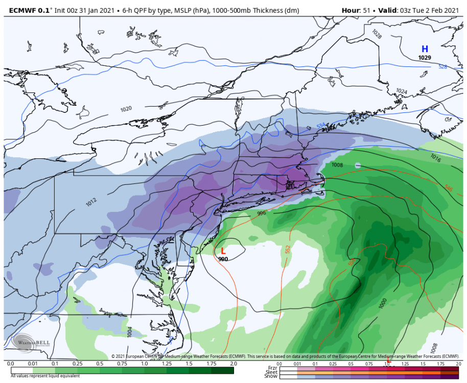
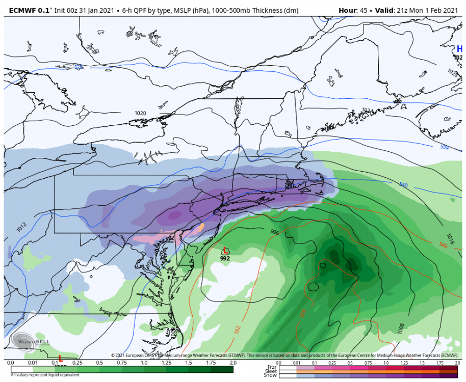
Neither the Euro nor the NAM are giving in. Interesting. In these situations, the NAM tends to win tbh. I said NAM and win in the same sentence.. yeah.
- 2,426 replies
-
- heavy snow
- ice pellets
-
(and 3 more)
Tagged with:
-
@jm1220 I would say that Euro is likely a bit too far North and West. A 30 mile SE shift is huge. We will see.
- 2,426 replies
-
- heavy snow
- ice pellets
-
(and 3 more)
Tagged with:
-
Euro is Western edge and tucked. Nam is Eastern edge. We have a rather tight consensus developing.
- 2,426 replies
-
- 1
-

-
- heavy snow
- ice pellets
-
(and 3 more)
Tagged with:
-
- 2,426 replies
-
- heavy snow
- ice pellets
-
(and 3 more)
Tagged with:
-
- 2,426 replies
-
- 2
-

-
- heavy snow
- ice pellets
-
(and 3 more)
Tagged with:
-
Yeah - Just did some research to double check myself. Turned out I was wrong. I remember when they got rid of the watches, they were contemplating losing the warings as well. Guess they overruled.
- 2,426 replies
-
- 1
-

-
- heavy snow
- ice pellets
-
(and 3 more)
Tagged with:
-
They did. Edit: I thought they did. They only purged the watches.
- 2,426 replies
-
- heavy snow
- ice pellets
-
(and 3 more)
Tagged with:
-
Yes. I was expecting the Pacific to pump the heights, flood the warmth and allow for several inches of rain into the Metro Area. Instead, we may end of with several inches of LEquiv snow.
- 2,426 replies
-
- heavy snow
- ice pellets
-
(and 3 more)
Tagged with:
-
Yeah... I remember both of those were pretty good for LI.
- 2,426 replies
-
- heavy snow
- ice pellets
-
(and 3 more)
Tagged with:
-
ICON is as good as a pop icon. Looks pretty but not much too it.
- 2,426 replies
-
- heavy snow
- ice pellets
-
(and 3 more)
Tagged with:
-
That crippled nyc and left persons stranded on highways.
- 2,426 replies
-
- heavy snow
- ice pellets
-
(and 3 more)
Tagged with:
-
LI may be lining up for a heck of a hit... I may need to get some crow to cook.
- 2,426 replies
-
- heavy snow
- ice pellets
-
(and 3 more)
Tagged with:
-
I agree with you. I was worried about this from the get go and then doubted myself with the confluence. But - like I stated - I originally thought that the Coastal plain would have a hard time taking a strong hit from this.
- 2,426 replies
-
- heavy snow
- ice pellets
-
(and 3 more)
Tagged with:
-
The pna continues to forecast going neutral, however, it keeps getting pushed back, and is now looking to potentially do so just after the storm. That withstanding, the negative tilt looks to hurt rather than help the Coastal plain and the amping looks to flood the Coastal plain. Again, I could be - and would gladly be - wrong. But just my two cents.
- 2,426 replies
-
- heavy snow
- ice pellets
-
(and 3 more)
Tagged with:
-
I said this on another board. An interior and North hit has made the most sense to me from day one. I know I waivered with confluence... However, I don't believe this is a Coastal plain hit. The pattern hasn't supported it all winter and the Pacific is again flexing its muscles. Combined with LA Nina, I really don't see the Coastal plain taking a hard hit. That withstanding, the big cities - and more specifically - N and W, I expect these areas to take a pretty hard hit. DC and BWI are in the game as well as they will stay west of the LP. Just my opinion. I've eaten plenty of crow before, so I wouldn't mind eating more (sustained me through covid) Lastly, the waters are warm. This will favor a quicker intensification and negative tilt. Likewise, if the storm stalls and the coast takes a prolonged period of easterly winds, this bodes ominously as well.
- 2,426 replies
-
- heavy snow
- ice pellets
-
(and 3 more)
Tagged with:
-
Any forecast for the area? Or still too early?
- 2,426 replies
-
- heavy snow
- ice pellets
-
(and 3 more)
Tagged with:


