MillvilleWx
-
Posts
4,884 -
Joined
-
Last visited
Content Type
Profiles
Blogs
Forums
American Weather
Media Demo
Store
Gallery
Everything posted by MillvilleWx
-
It's going to be crazy here soon. Rates have picked up last 10-15 minutes. That stuff out by you is juicy. You should definitely make a good catch up in the next 2-3 hrs, although I might be leveling with you soon on rates. Just a great storm so far for our areas.
-
The flake size will increase and should be pretty solid, but this evening will be the best time frame for larger flakes! The radar looks insanely good right now and is setting up for a thorough beat down for several hours probably starting in the next hour or so. I'm hoping we can hit a foot!
-
It's been just pouring snow out our way. You can even see the flakes fall in the dark out the window it's coming down so steady. I measured 1.2" in a hour last ob. If this keeps up, we'll be over 10" by storms end, no question.
-
It's always nice to be circled
-
Not likely with this part. The best chance, albeit pretty small will be with the vort pass later today. More dynamic in nature. That will feature larger dendrites that carry more appreciable ratios. If we can somehow luck into that feature closing off south of us for even a few hours, there will be some very happy people in this sub-forum, if they aren't already!
-
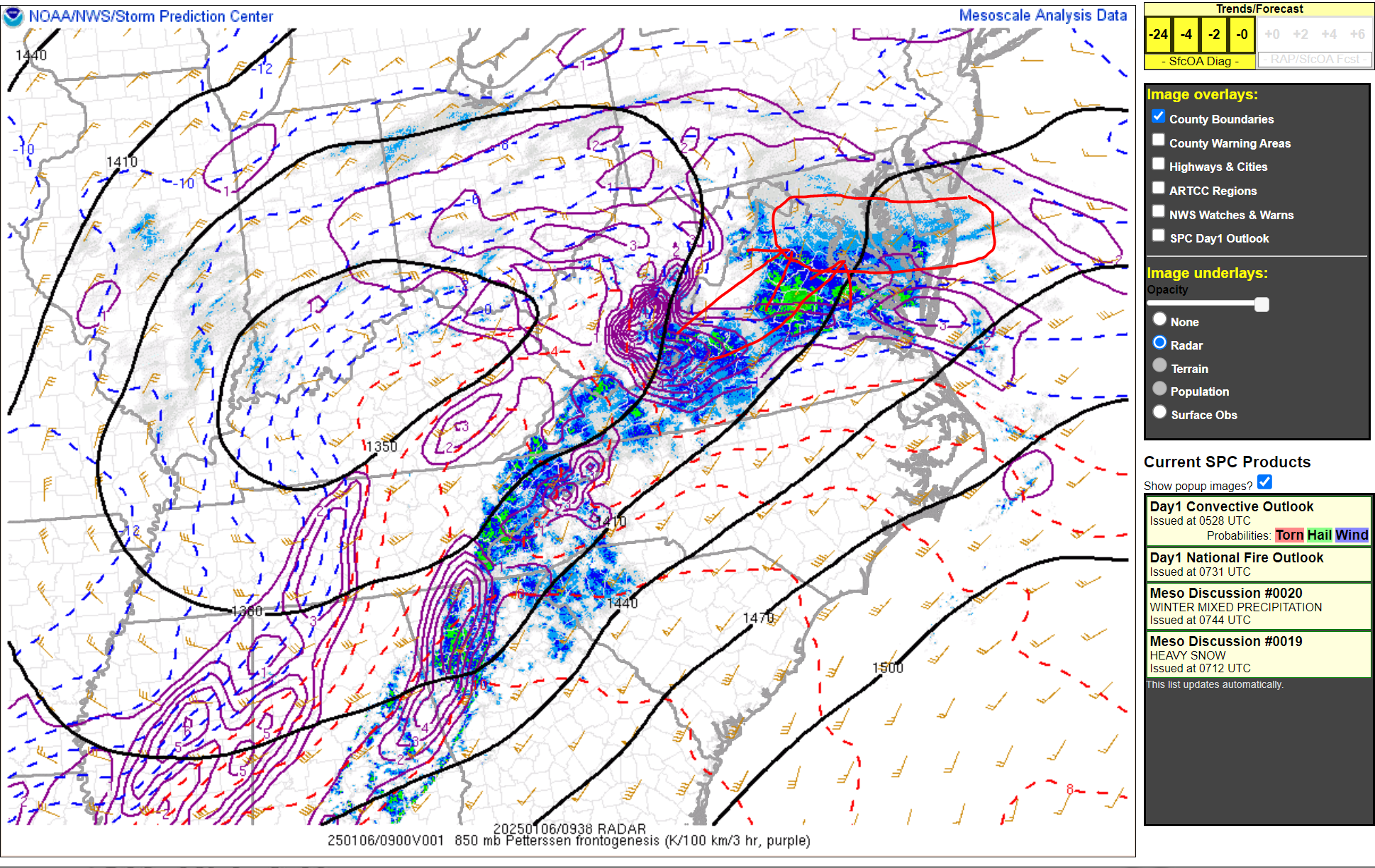
Mesoanalysis still has the best 85H FGEN well to the south closer to CHO and points southwest. This will migrate northeastward over the next several hours with the best forcing likely positioned in that circle above the arrows. This is the area that could see a steady 1-2"/hr rate period that will last 3-6 hrs before it moves off to the east and that's when the rates will subside before the next round comes through later today. By then, many inside that circle will be at 6-12" and then we wait for the bonus snow with the vort pass to our south. Good times here y'all with the best still to come!
-
I'd say within the next few hours is when we'll hit the heaviest part for you guys. I'm a little later and linger longer out my way. Sweet spot right now is just to the east of you which has been well modeled by CAMs thus far. Still a solid storm for your area for sure.
-
430am Measurement 3.5" on the nose SN to SN+ 25.4/24.9 Those 10-12" totals are looking pretty realistic for this area now.
-
Typically on a snow measurement, you want to keep to the "tens" place after the decimal, so anything that ends with a 5 like ___.15, just round up to the next digit. It won't inflate totals much. You'll be good!
-
I'm doing hourly measurements in one area and 6 hourly in another for the official. Want to see any compaction differences since....I can lol Measurement incoming in 5-10 min Steady Moderate to borderline heavy snow. Just puking small flakes at a break neck pace right now. Flake size is slowly increasing. Best FGEN will be in the area in 2-3 hrs, then "Katy bar the door..."
-
We can round to 3.2"
-
2.3" in Edgewater as of 330am SN 25.5/24.2
-
Looking good for us, Howard. Enjoy the fun!
-
I'm reaction limited, so I will say it right back! Enjoy my man. This one is good one for us
-
It's been a solid crescendo effect on the snowfall already. I started 1.5 hrs ago and already at 1.3". Glorious
-
Officially 1.3" in Edgewater as of 245 AM SN 25.7/24.4 Absolutely amazing out. Well ahead of schedule
-
Love to hear it my man! We are solidly racking up the snow here. Haven't measured yet, but got to be pushing towards that 1st inch already. Steady light to moderate snow with heavier echoes starting to push up towards our hoods. Life is good!
-
Let's go!!!!
-
I've been waiting for that MCD to come out all day lol Thanks Yoda for the share! Let's keep it rolling
-
Same lol
-
Yeah. It's really impressive down there. The system has a long way to go. We just started the goods for the area. Let's keep this party going, shall we
-
Snow is a steady light variety but picking up in intensity slowly. Everything is completely covered with a solid coating. Storm just begun too. Great start with the heavier returns still off to the southwest with a ways to go.
-
The modeled Kuchera ratio for this part of the storm is 8-10:1 with 12:1 all the way into Carroll County. It doesn't improve until after 10z when the better forcing arrives, and even then 9-10:1 for DC and 10-11:1 for an average unless under better banding. 12-15:1 for areas along and north of I-70. Kuchera is doing fine so far and the model algorithm snow from the HRRR is also fine. I don't see anything wrong the forecast right now.
-
Beautiful!
-
Officially light snow in Edgewater. Every single flake sticking as expected. Temp 29.5/16.3