MillvilleWx
-
Posts
5,534 -
Joined
-
Last visited
Content Type
Profiles
Blogs
Forums
American Weather
Media Demo
Store
Gallery
Everything posted by MillvilleWx
-

Feb 22nd/23rd "There's no way..." Obs Thread
MillvilleWx replied to Maestrobjwa's topic in Mid Atlantic
I think I'll just come out and say the nowcasting trends of the expected upper level behavior will probably lead to a lower end of any accumulation range for areas west of the Bay, expect those under the norlun trough. I think even I will get about 4-5" or so just west of the Bay. Eastern shore still looks ripe. Hope I'm wrong, but I'm not seeing a favorable 5H progression for prolonged snow here. The jog east-northeast of the SLP once it gets to the latitude of DE is basically on all guidance now. Unless that changes, probably going to be tough to reach >6" for anywhere west the western shore of the Bay. Northeast MD, Eastern Shore, and points northeast should still do well enough. I'm going to enjoy whatever I get. -
Feb 22nd/23rd "There's no way..." Obs Thread
MillvilleWx replied to Maestrobjwa's topic in Mid Atlantic
Trough is tilting negative currently, so we'll see the 500mb heights probably close off over VA within the next 2-4hrs. -
Feb 22nd/23rd "There's no way..." Obs Thread
MillvilleWx replied to Maestrobjwa's topic in Mid Atlantic
My parents just sent me videos. It is absolutely PUKING snow there right now. Everything is covered and accumulating efficiently. The Lower Slower DE is about to see some potentially historic snowfall from this one. 10+ is all but a lock. -
Feb 22nd/23rd "There's no way..." Obs Thread
MillvilleWx replied to Maestrobjwa's topic in Mid Atlantic
It's actually more of a product of the best is yet to come, but heaviest rates are over the eastern shore right now due to a strong 7H FGEN alignment and closer fetch off the Atlantic. We are in a traditional Miller B where the moisture transport is likely to be weak from southern stream influences outside what occurred this morning from a lead wave that was ripping ahead of the mean trough. This is going as planned, and unfortunately, the proxy of the low and general timing of when the 5H pattern is expected to close off and pass under us will benefit those further east and northeast and only offer a small consolation prize (outside the norlun trough). Was hoping the 5H pattern closed sooner which would've helped us a ton, but the 06z runs last night kind of started the very slow bleed the wrong way in that regard and it's basically going to be a "just missed" scenario for a bigger storm, but we still get some snow out of it, which we can't say for all Miller B's. -
Feb 22nd/23rd "There's no way..." Obs Thread
MillvilleWx replied to Maestrobjwa's topic in Mid Atlantic
I never buy the NAM for any reason. NAMNest thermals and sometimes the QPF, but otherwise, the 12km parent I ignore almost exclusively. -
Feb 22nd/23rd "There's no way..." Obs Thread
MillvilleWx replied to Maestrobjwa's topic in Mid Atlantic
It's not yet at that latitude. Won't start appearing for another 3-4 hrs. It's somewhat visible into west-central PA right now, but the dynamics aren't there yet for down this way. -
Feb 22nd/23rd "There's no way..." Obs Thread
MillvilleWx replied to Maestrobjwa's topic in Mid Atlantic
Video from parents shows everything is covered and roads are caving it’s coming down so hard. Absolutely massive flakes. This is going to be a special storm for the Southern DE. -
Feb 22nd/23rd "There's no way..." Obs Thread
MillvilleWx replied to Maestrobjwa's topic in Mid Atlantic
Seaford is not going to mix. I'd go if I had the chance! -
Feb 22nd/23rd "There's no way..." Obs Thread
MillvilleWx replied to Maestrobjwa's topic in Mid Atlantic
Ahhh, I read into your comment incorrectly. No worries! -
Feb 22nd/23rd "There's no way..." Obs Thread
MillvilleWx replied to Maestrobjwa's topic in Mid Atlantic
Snowing at my parents place west of Rehoboth. Massive flakes and sticking to the grass and tables outside. -
Feb 22nd/23rd "There's no way..." Obs Thread
MillvilleWx replied to Maestrobjwa's topic in Mid Atlantic
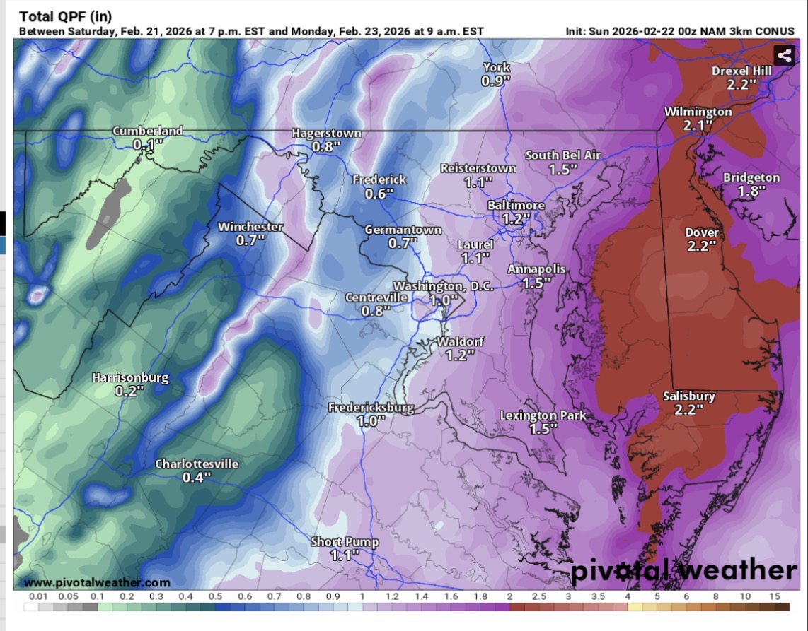
The wetbulb temp for Frederick is right at freezing and I would not expect the valley to get any accumulation until after sunset. Storm is really just getting started. -
Feb 22nd/23rd "There's no way..." Obs Thread
MillvilleWx replied to Maestrobjwa's topic in Mid Atlantic
I'm going to be totally honest with you...I have no clue how you managed to pull that off!! Potentially rates and you just happen to be better off? I'd take my money and run!!! -
Feb 22nd/23rd "There's no way..." Obs Thread
MillvilleWx replied to Maestrobjwa's topic in Mid Atlantic
Man, a DASH of something would've been helpful here -
Feb 22nd/23rd "There's no way..." Obs Thread
MillvilleWx replied to Maestrobjwa's topic in Mid Atlantic
Fair question, and tbh, that's a question for the Sterling WFO. WPC actually does our own snow forecast and we've been lower than they have for this one for our neck of the woods. I have had you around 6-9" when I forecasted last 3 days. We coordinate on things, but the end of the day, the snowfall forecasts are the WFO's for their respective CWA's and they can refer to ours for cohesiveness. You put 10 meteorologists into a room and you'll get 11 forecasts. It's been a tough one outside NJ/LI/Mass since they are getting creamed no matter what. Btw, we have between 0.5-0.6" for your area after the flip with ~6-6.5" of snow accumulation, so could very well hit the lower half of the forecast, but probably a safer forecast with 4-8" for your hood. That's just my 2cents. Hopefully we get hit good for 4-6 hrs before things wind down. Going to be really nice dendrites with this one. -
Feb 22nd/23rd "There's no way..." Obs Thread
MillvilleWx replied to Maestrobjwa's topic in Mid Atlantic
That storm will not be repeated here, but similar premise! Upper levels will improve for these parts in the evening. That's when you'll see more banding structures and things begin to pick up. -
Feb 22nd/23rd "There's no way..." Obs Thread
MillvilleWx replied to Maestrobjwa's topic in Mid Atlantic
Everything is going as planned. Accums won't really start for another 3-5 hrs, especially after sunset. Temps will drop to near and below freezing and rates will increase. The ULL formation to our south has not even started yet. Hours to go before the good stuff. Go out, grab a bite, have a drink or two, relax, take a nap, celebrate the USA Gold, then enjoy snow falling later. It'll do what it's going to do. Everyone stay safe, especially our Delmarva brethren. -
Feb 22nd/23rd "There's no way..." Obs Thread
MillvilleWx replied to Maestrobjwa's topic in Mid Atlantic
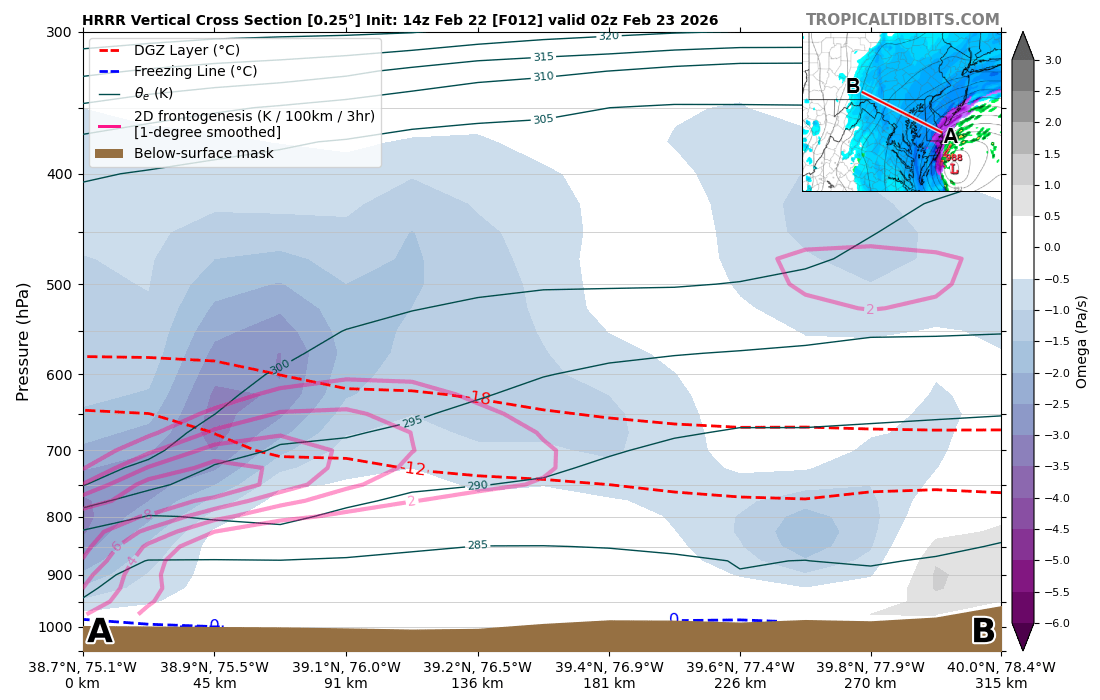
Beautiful cross-section across MD from the shore to the Alleghany front. Decent omega throughout the region within the DGZ should allow for nice dendrites and efficient accumulations. This was taken from the 14z HRRR around 02z (9PM EST). Once it starts snowing, it'll absolutely accumulate efficiently. Areas of the Delmarva are going to get absolutely crushed. 1-2"/hr for hours for those areas. 10+ is all but certain for any area east of Cambridge longitude. Will be a fun evening for all!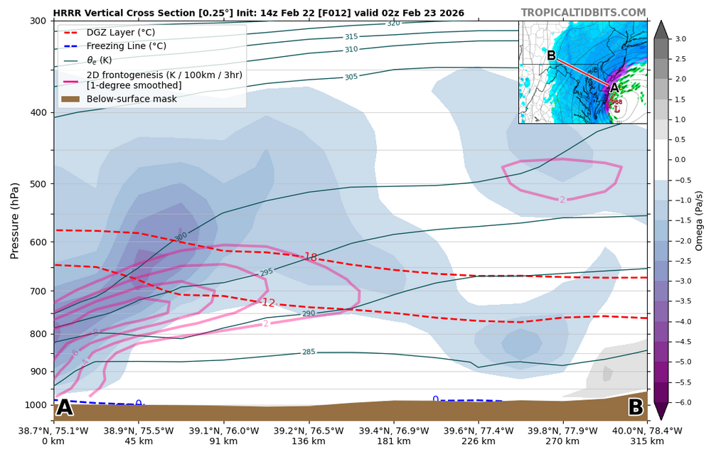
-
Feb 22nd/23rd "There's no way..." Obs Thread
MillvilleWx replied to Maestrobjwa's topic in Mid Atlantic
I wrote for the storm the past few days Jeb on the Heavy Snow and Ice Discussion. You can view them here https://www.wpc.ncep.noaa.gov/discussions/hpcdiscussions.php?disc=qpfhsd&version=0&fmt=reg Click on version 1 and you'll see mine from yesterday. My colleague wrote the current discussion and it's also very well done, per usual -
Feb 22nd/23rd "There's no way..." Obs Thread
MillvilleWx replied to Maestrobjwa's topic in Mid Atlantic
They'll be better suited in that area compared to the coast. The coastal areas in Sussex will be awhile before they can go anywhere. My parents are in that area and I'm not expecting them to be able to move till Tuesday. -
Feb 22nd/23rd "There's no way..." Obs Thread
MillvilleWx replied to Maestrobjwa's topic in Mid Atlantic
Seaford is in a great spot for this one. Milford, DE would be an awesome choice too. No matter the location in DE, if you are 10+ miles inland, you will be golden. -
Central PA Winter 25/26 Discussion and Obs
MillvilleWx replied to MAG5035's topic in Upstate New York/Pennsylvania
Thanks! I take pride in my discussions, especially for high impact events. This was a fun one today. I wrote yesterday too, but that conveyed more uncertainty. Today, I let it rip. -
Central PA Winter 25/26 Discussion and Obs
MillvilleWx replied to MAG5035's topic in Upstate New York/Pennsylvania
Here you go!! https://www.wpc.ncep.noaa.gov/discussions/hpcdiscussions.php?disc=qpfhsd -
Feb 22nd/23rd "There's no way..." Obs Thread
MillvilleWx replied to Maestrobjwa's topic in Mid Atlantic
If you take 80% of Kuchera, this is a bonafide MECS for areas east of I-95 and a SECS for those west except northeastern MD. HECS for Delaware and points northeast. Absolutely insane consistency right now on these mega outputs. -
Feb 22nd/23rd "There's no way..." Obs Thread
MillvilleWx replied to Maestrobjwa's topic in Mid Atlantic
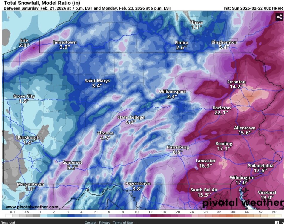
Not so sure about that my man. Here’s through 38 hrs….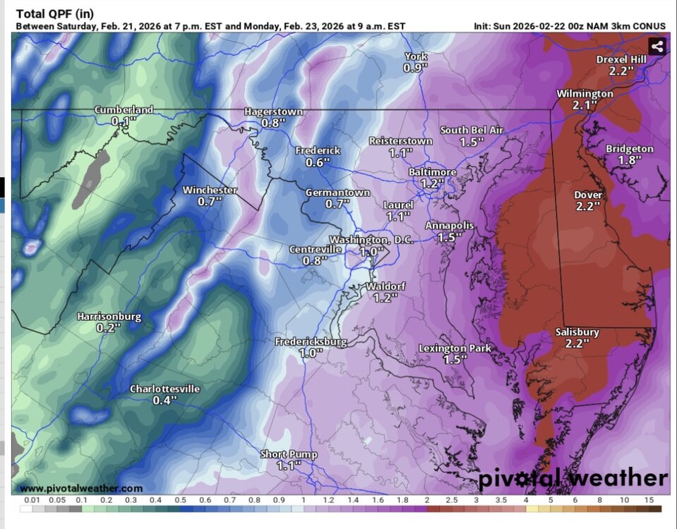
-
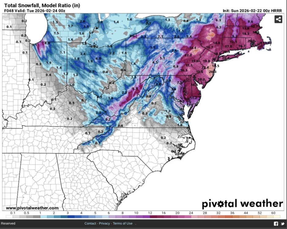
Central PA Winter 25/26 Discussion and Obs
MillvilleWx replied to MAG5035's topic in Upstate New York/Pennsylvania
For your viewing pleasure!! Should be a great storm for many in here. I hope y’all get hammered with the goods!! Will check in tomorrow