MillvilleWx
-
Posts
5,543 -
Joined
-
Last visited
Content Type
Profiles
Blogs
Forums
American Weather
Media Demo
Store
Gallery
Everything posted by MillvilleWx
-
I think 5-9” is a good call for your hood. You guys down there have had a hell of a winter for your climo. Enjoy!!
-
This is a truly scared group in here. I just looked at guidance with the QPF distribution and this is still looking exactly as planned. The most QPF deficient model is the HRRR at range and even that is 1-4” north of I-70, 3-6” Central MD, 4-8” Rt50 on south with even some 8+ possible in Calvert and Northern St Mary’s over into interior lower slower Sussex Co DE. I haven’t seen anything that looks very different. I like what the offices have for WWA and WSW’s across the board. It’s gonna snow!
-
No changes to my thoughts from overnight. The 12z NAMNest looks pretty solid for many with the max located along and south of Rt50 with the heaviest likely in similar areas that hit 1/6. Another solid storm for the lowlands it seems.
-
My thoughts haven’t really changed too much. This storm is really looking like a 70-80% of what happened on 1/6. Similar thought of the max somewhere along and south of Rt50 with the best spot between Fredericksburg up to Annapolis and points in-between on the west side of the Bay. Higher elevations west of Fredericksburg will also see some significant accumulations that could very well be within the maxima. 3-6” is very likely (85+%), 5-8” is probably the median/mean outcomes, and the high side is 9-10” as the opportunity for >10” is unlikely considering the forward propagation speed along with marginal thermals in the beginning before improvement in the evening Tuesday through the overnight. A solid storm incoming which I’m sure will produce a few surprises.
-
This is usually what I do as well at this range. Interestingly enough, the NAMNest is basically doing that all by itself and looks very reasonable. Might be getting close to locking down a result here. Goal posts narrowing. I’m getting a little more interested in part 2 as well. Could be sneaky to add a little more snow before any flip.
-
Good observation, Pete! One of the reasons I like the Rt50 corridor at this juncture as the 85H FGEN alignment looks decent for areas along and south of the Rt50 latitude. Further north could very well achieve the closer 10:1 ratio, so they have the benefit of having both variables achieve success. I think this event is like a 60-80% version of 1/6 along and south of I-70. The main difference is a little more WSW-ENE alignment to the primary QPF field, so areas downstream of Rt15 might be a little better within the moisture advection pattern. Nothing crazy, but definitely a little better than the straight east-west orientation from the previous event. Thanks for keeping everyone abreast on the adjustments and analysis. I’ll be back on Tuesday to man the fort in Ops
-
Can’t say I hate the trends for our areas. Rt 50 might be the place to be for this one. We shall see, but our threat for WSW has been slowly increasing the past 24 hrs
-
Yeah. That’s likely too cold. There’s a few PWS in Bowley’s in the 30s, but still not near 32. I’m sitting in the 30s in my areas, but surrounded by them as well.
-
Just got out of bed and got my day going after finishing my last night shift (Woot!) This was actually a blessing around the lowlands. We definitely needed this rain so I’ll take it. Thin layer of ice on elevated surfaces this morning, but roads and sidewalks just wet. I’ll accept. We could be a little dicey on Saturday. Have to see how it plays out.
-
Just drove home from College Park. Main roads fine. Davidsonville Rd to the west of Annapolis/Edgewater had some trees sag to the ground going southbound so a County officer had to block the road so no one would hit it. Had to go around, but that was the worst ice in the area. 33/33 with light to moderate rain most of the way home. Non-event for the lowlands, as expected.
-
Hmmmmm, we may have something here ladies and gents I am cautiously optimistic this go around. Should be a fun week+
-
Meanwhile the FV3 still has no real precip beyond 06z with a majority out in Ohio
-
"Gentleman, we have won two games in a row. If we win one again, that's what's called a winning streak..."
-
I do feel the CAD lasts longer for those west of the fall line, but I also think the efficiency marker for this event is likely to be a little less than what the ECMWF is taking into account. This is a marginally cold enough air mass being forecast with wet bulbs at 27-31F across the region. Latent heat release will allow for temps to slowly rise during the overnight with most areas at freezing once we get into the morning. One thing to keep an eye on is rates as lighter precip will allow for better accretion efficiency and less opportunity for faster warmer due to those latent heat processes. NBM is basically half of what the ECMWF is implying, but is also a bit more in the sleet realm which would also cut ice accretion, but still be impactful. I think areas that have the best shot at >0.15" accretion at this juncture are areas >900' west of the fall line. Catoctins, Northern Carroll along Parrs ridge, South Mountain, and areas west of Cumberland. 0.05-0.15" for many others, plenty to make it impactful for restricting travel. I will say that if this busts, it might be more of a positive bust since the airmass is very shallow but still fairly fresh with the advection pattern occurring less than 24 hrs prior. We shall see!
-
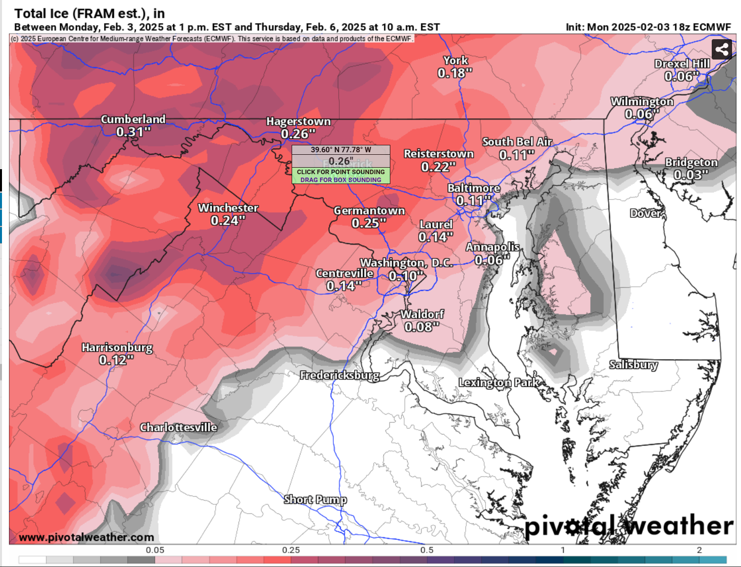
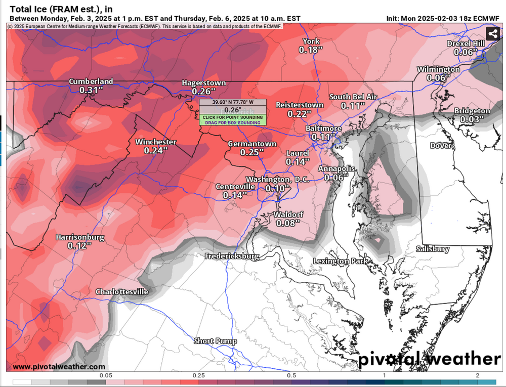
Still think this is a bit overdone, but still increasingly significant nonetheless. FRAM is what you want to estimated ice accretion. Accumulated Freezing Rain is just model output of QPF that would fall as ZR. It doesn't take into account other variables that provide more information on efficiency. Looking icy Thursday morning for many. Below is the 18z ECMWF FRAM output
-
I almost fell out of my chair
-
There's an article in the local Lancaster Newspaper about that event. It was incredibly wild to see.
-
Thank you for the kind words my friend. It was a pretty horrible month for me. Grandmothers funeral was Thursday with the viewing the day before. My mouth is healing fine, although had a scare and emergency dental visit that cleared me of anything bad, but have to switch from Sonicare tooth brush to a manual soft bristle until cleared. Ravens L sucked too. Just a brutal month overall. Hopefully February and beyond are better. I appreciate the thoughts and prayers very much, so thank you
-
One things for sure in this upcoming pattern, there will be a train of waves moving across the country into our neck of the woods. Thermal gradient placement and amplification regime once east of the Mississippi will be everything. Give us the cold and we will have numerous chances at frozen, whether it be in the form of all frozen or thump to flip remains to be seen, but both the GFS and ECMWF are now in tandem with the potential. Should be a fun pattern to monitor.
-
For the last 3 years I have been adamant that no one beats the Ravens like the Ravens. Holds true every year and it's incredibly annoying.
-
The fact we verified some of the insane totals the models were spitting out for days still blows my mind to this day. It was truly a marvel.
-
Well, ended up getting the tooth extraction yesterday afternoon and so far so good on the pain front. Just the standard post surgery pain. Ice and ibuprofen my bff’s. Resting. I’ll be back to normal soon enough. It did end up being a fractured tooth below the gum line that helped cause an infection. Got the tooth out and cleaned out the infection. On antibiotics for 7 days to clear it out completely from my system. Side note, nitrous oxide is some damn good stuff. Between that really good numbing, I felt asbsolutely nothing during the surgery. Probably the most relaxed I’ve been in over a month. Incredible.
-
Season Total: 11.9”
-
Man, I’m glad I saw that 10+” snow storm earlier this month cuz the start to this year has been absolute dogshit Rough storm today Ravens blow it Tooth needs to be extracted Grandmother dies Some other personal stuff Just freakin awful. My God. I hope the rest of the year is better.