MillvilleWx
-
Posts
4,884 -
Joined
-
Last visited
Content Type
Profiles
Blogs
Forums
American Weather
Media Demo
Store
Gallery
Everything posted by MillvilleWx
-
Season Total: 18.9"
-
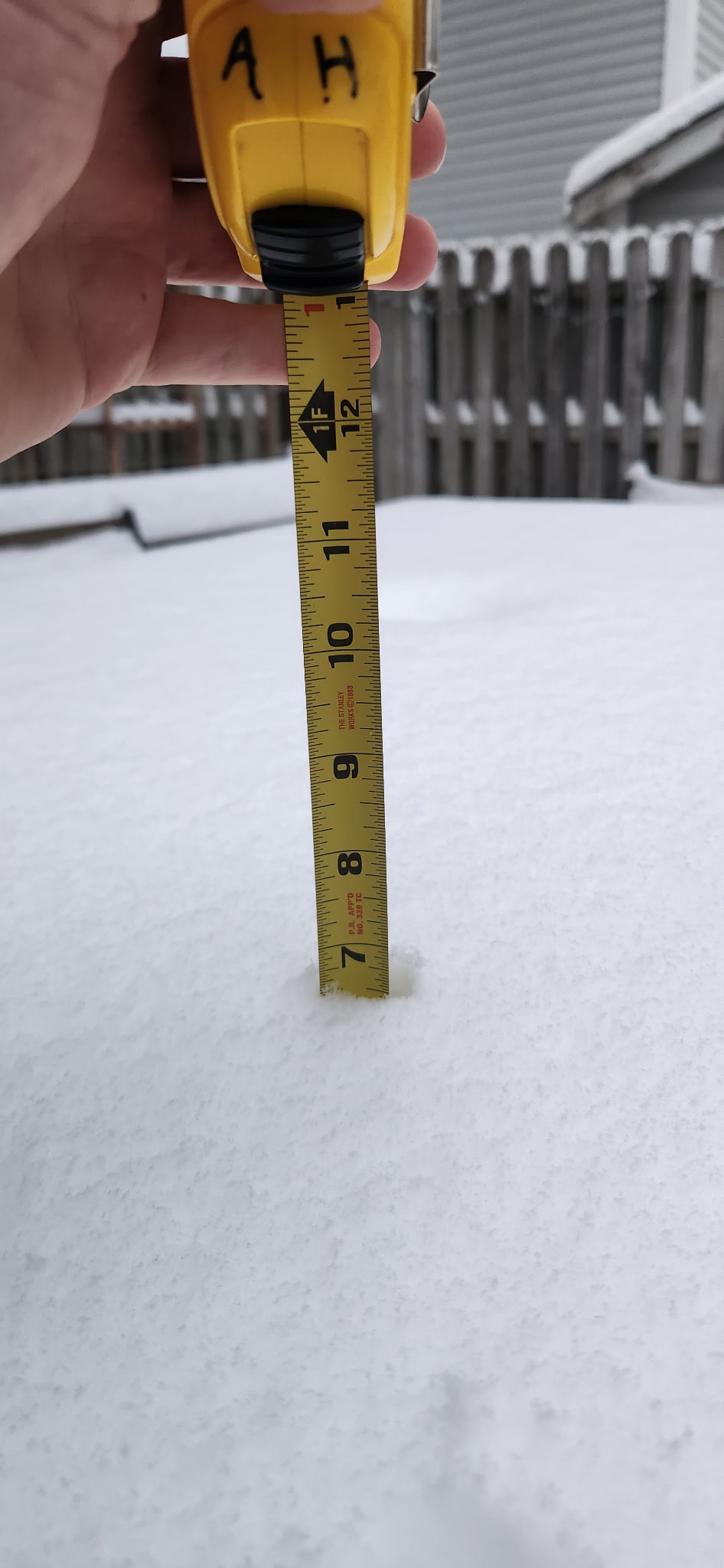
Well, just got a picture from my place and the snow depth measurement at the house is 7" on the nose. I am stunned!! What a winter for the coastal areas of AA and Southern MD.
-
Great to hear! I was in CP, so don't know the final total for my hood, but according to my wife last night before bed, we had a little over 4.5", so likely touched 5.5-6" when looking back at radar. Solid storm again for our neck of the woods. WAY over climo now at my 16' of elevation lol
-
About to head to sleep. Estimated 4-4.5” here in College Park. Still a snow anus for the area inside the beltway, but man is it beautiful around here when it’s a true snow globe. Hopefully we can crack 5.5-6” with this inside the beltway. It truly just wants to snow along and south of Rt50 this year. Goodnight everyone. 445am comes around pretty quickly. Enjoy the fruits of Mother Nature

-
My parents just west of Rehoboth have been getting absolutely steamrolled over that way. Congrats and enjoy!
-
Oh, that Meso was fine for the DC area and NoVA to points east. Anything north of I-70 makes no sense. Hopefully I’m wrong and everyone cashes. I just don’t see 1+”/hr rates further north. Sharp cutoff likely
-
I know you’re just messin, but if they know that, then kudos to that person lol Highly doubt anyone there is even from this area of the country. Its majority people from the south and plains. The severe weenies from birth.
-
They didn’t see anything imo. It’s a terrible forecast and someone who issued probably doesn’t understand this area. I love the people at SPC and they do an amazing job, but every now and then they make me scratch my head. Today is one of those times.
-
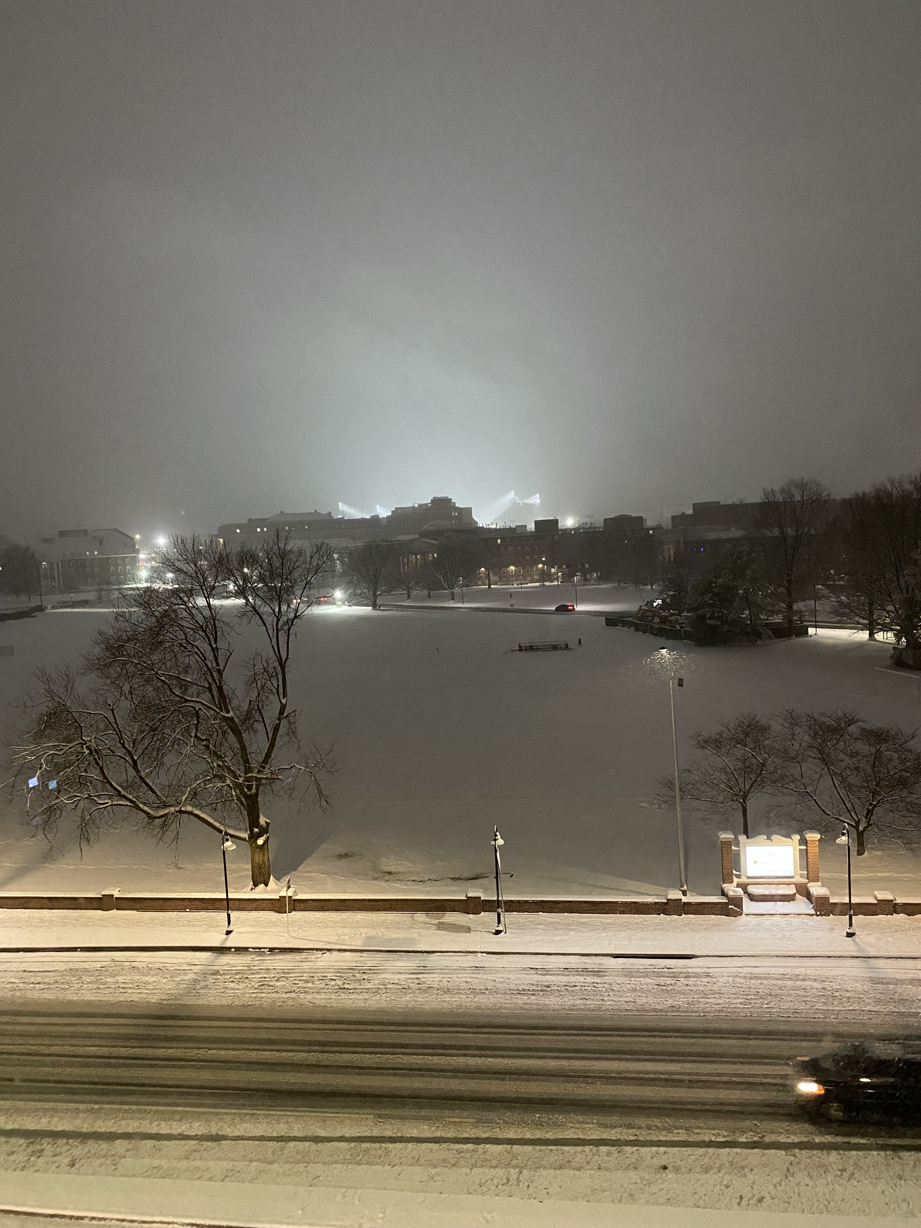
Staying in CP for the night since I have work early in the AM tomorrow. This area might actually be the worst snow place in the entire region. Rt50 on south is the area you want to be in. Didn’t agree at all with the northern extent of that Meso SPC issued. Oh well. Y’all enjoy. I’ll accept whatever flakes I get here at the University area.
-
Your area looks awesome. Enjoy, and take lots of pictures!!
-
My final call is: SoPA through N MD down to I-70 latitude: 1-4" with a North-South gradient Central MD over into the Central East Shore north of Rt50: 2-5" with a Northwest-Southeast gradient of low to high Rt50 to Waldorf Latitude: 3-6" with more further south and east DC metro: 3-5" Baltimore metro: 2-4" Lower Slower DE: 3-7"; max away from coast Northern half of DE: 1-4" with North-South gradient SoMD south of Waldorf: 5-8" Georgetown: Sadness
-
12z does look a bit better, so hopefully we continue to step in the right direction. I'm telling you, I like what I see on satellite, so hopefully it'll come around. I'd like to bring this one home. Also, because of work obligations for early tomorrow morning, I will be stationed in College Park for this one at a local hotel. So if the DC area fails, @stormtracker can just blame me. I'm a meteorologist and I'm married. I'm used to getting blamed for things
-
That's the one thing about the HRRR. It has such wild swings in failure and being right that it's hard to discern when it is on to something or on something... Working a primary convective based desk has allowed me to see both sides of that coin a fair amount. The 13z run will have the 12z data ingest, so that would be the run to really keep an eye on trends. Still a ways before the event for here in HRRR time, so there's an opportunity it corrects and we'll be good to go. Much of the suite doesn't agree with it. ARW is the closest thing to the HRRR at the moment, but it's still better spatially with the QPF distribution. I'm hoping the HRRR is having convective scheme issues and robbing the meridional push of the main 7H moisture fetch.
-
I want to agree with you there, but I will say that if this fails like the HRRR is insinuating, this would be an egregious black eye on NWP outside one model that goes out only 48 hrs. I'm actually running into pessimism now looking at the HRRR consistently degrading this event. We are fast approaching its window where we would want to pay closer attention and it's not very enthusiastic, even within the heaviest precip core in VA. I'm going down guns blazing with my call, but this could end up being a ho-hum event. Sorry to sound negative, but the HRRR is not budging and it may just be on to something. Hopefully it's just ON something and missing the big picture. Fingers crossed
-
I feel you for you guys up there and my old stomping grounds I grew up at. Hopefully we get a monster so we can all celebrate. Seriously needed!
-
I think 5-9” is a good call for your hood. You guys down there have had a hell of a winter for your climo. Enjoy!!
-
This is a truly scared group in here. I just looked at guidance with the QPF distribution and this is still looking exactly as planned. The most QPF deficient model is the HRRR at range and even that is 1-4” north of I-70, 3-6” Central MD, 4-8” Rt50 on south with even some 8+ possible in Calvert and Northern St Mary’s over into interior lower slower Sussex Co DE. I haven’t seen anything that looks very different. I like what the offices have for WWA and WSW’s across the board. It’s gonna snow!
-
No changes to my thoughts from overnight. The 12z NAMNest looks pretty solid for many with the max located along and south of Rt50 with the heaviest likely in similar areas that hit 1/6. Another solid storm for the lowlands it seems.
-
My thoughts haven’t really changed too much. This storm is really looking like a 70-80% of what happened on 1/6. Similar thought of the max somewhere along and south of Rt50 with the best spot between Fredericksburg up to Annapolis and points in-between on the west side of the Bay. Higher elevations west of Fredericksburg will also see some significant accumulations that could very well be within the maxima. 3-6” is very likely (85+%), 5-8” is probably the median/mean outcomes, and the high side is 9-10” as the opportunity for >10” is unlikely considering the forward propagation speed along with marginal thermals in the beginning before improvement in the evening Tuesday through the overnight. A solid storm incoming which I’m sure will produce a few surprises.
-
This is usually what I do as well at this range. Interestingly enough, the NAMNest is basically doing that all by itself and looks very reasonable. Might be getting close to locking down a result here. Goal posts narrowing. I’m getting a little more interested in part 2 as well. Could be sneaky to add a little more snow before any flip.
-
Good observation, Pete! One of the reasons I like the Rt50 corridor at this juncture as the 85H FGEN alignment looks decent for areas along and south of the Rt50 latitude. Further north could very well achieve the closer 10:1 ratio, so they have the benefit of having both variables achieve success. I think this event is like a 60-80% version of 1/6 along and south of I-70. The main difference is a little more WSW-ENE alignment to the primary QPF field, so areas downstream of Rt15 might be a little better within the moisture advection pattern. Nothing crazy, but definitely a little better than the straight east-west orientation from the previous event. Thanks for keeping everyone abreast on the adjustments and analysis. I’ll be back on Tuesday to man the fort in Ops
-
Can’t say I hate the trends for our areas. Rt 50 might be the place to be for this one. We shall see, but our threat for WSW has been slowly increasing the past 24 hrs
-
Yeah. That’s likely too cold. There’s a few PWS in Bowley’s in the 30s, but still not near 32. I’m sitting in the 30s in my areas, but surrounded by them as well.
-
Just got out of bed and got my day going after finishing my last night shift (Woot!) This was actually a blessing around the lowlands. We definitely needed this rain so I’ll take it. Thin layer of ice on elevated surfaces this morning, but roads and sidewalks just wet. I’ll accept. We could be a little dicey on Saturday. Have to see how it plays out.