MillvilleWx
-
Posts
4,884 -
Joined
-
Last visited
Content Type
Profiles
Blogs
Forums
American Weather
Media Demo
Store
Gallery
Everything posted by MillvilleWx
-

Jan 15-16 Storm Threat Thread: The Return of Hope??
MillvilleWx replied to stormtracker's topic in Mid Atlantic
NWS went to hazard simplification due to social sciences showing that public interpretation was confused with the various different products. WWA/WSW/Blizzard Warning will be the primary hazards now with an Ice Storm Warning for primary high impact freezing rain only events. This has received a positive reception so far, so don’t expect anything from the past to return. -
Beautiful! We’re at the shore visiting my parents. We’ll be home tomorrow for the storm. Finally a nice storm for Frederick proper!
-
Jan 15-16 Storm Threat Thread: The Return of Hope??
MillvilleWx replied to stormtracker's topic in Mid Atlantic
Well, the trends at 5H are undeniable. Might actually have to break out a discussion for the forum tonight A general 2-4” is increasing in probability. Can see a 5-6” jackpot in this as well. Great trends so far. Let’s reel this one in -
Jan 15-16 Storm Threat Thread: The Return of Hope??
MillvilleWx replied to stormtracker's topic in Mid Atlantic
Nice little event brewing. The transformation of the event evolution is something fun to watch. We are now in the crosshairs of higher ratio fluff potential. I haven’t looked deeper into soundings, but I can tell spatially that upstairs will be pretty darn cold. Enough lift and we can get a legit WWA type scenario for part of the subforum. I might have more tomorrow as we draw closer. Trends are very positive currently. Let’s see where we are heading into tomorrow evening. 1-4” with locally up to 5” is well within a reasonable outcome right now and not at all far fetched. -
Jan 15-16 Storm Threat Thread: Do we finally win or get Saltburned?
MillvilleWx replied to H2O's topic in Mid Atlantic
Should be pretty for it falling. I’m off, so my plan is to go where it is falling and enjoying myself.- 425 replies
-
- 4
-

-
- jinx
- kiss of death
- (and 3 more)
-
Jan 15-16 Storm Threat Thread: Do we finally win or get Saltburned?
MillvilleWx replied to H2O's topic in Mid Atlantic
Well, looks like a light event or nothing which has been my fear overall. Was never into the amped idea. No storm or scraper. Ensembles trending SE was a hairbringer. NBM I imagine will follow suit, but 1-2” is very possible. Better coverage for NW of the fall line where temps should stay below 32° on Tuesday.- 425 replies
-
- 6
-
-

-
- jinx
- kiss of death
- (and 3 more)
-
There’s certainly some integral parts to assess in that area and the way they are handled on guidance. I would imagine this is one important part to the puzzle in the downstream pattern. Kind of wild to see such massive differences at these leads into an event. A model battle in that area might be what sends our setup in either direction.
-
Jan Medium/Long Range Disco 2: Total Obliteration is Coming
MillvilleWx replied to Jebman's topic in Mid Atlantic
This is incredibly important. NBM is a great tool to see trends in the means. The amount of data that is incorporated into the blend aids in a lot of probabilistic data and limits biases. If you guys recall, when the NBM kept trimming snow from the means on the lead up to the last event here, that was a sign that that the trend was moving the wrong direction and despite some of the guidance indicating a better result, it never wavered. This is probably one of the better ensemble tools to utilize when in the medium range and closer in. This is a great trend to see and will be paying close attention to this over the weekend. -
Hey guys! Popping in to provide some thoughts. Yesterday I liked the trends, outside the Euro which is currently on its own with regards to the 5H pattern. I mentioned in the MA thread yesterday about suppression or no storm concerns given the chaotic upper level vorticity pattern across the NH. This storm currently developing across the mid-section will help set the stage in a multitude of ways for what could occur next week. One of the things I like is the multiple ways to score in this event, whether that be a marginal event or a SECS/MECS if all breaks the right way and we induce phasing at the right time. Until we get a full resolve for what occurs with this current system, it will be a feedback mechanism for the medium range. I do love seeing increased ensemble support and the blend either maintaining a solid depiction of areal snow coverage of 2-3+”, and/or improving in the means and median of potential outcomes. Still got time to see some significant shifts within the surface evolution, but I say by Sunday we’ll have a general idea and all systems would be go if everything is in-sync. LSV and points northeast are the primary for this pattern, but the central and west-central folks could certainly get in on the action with high-ratio fluff in the right evolution. Fun times!
-
Jan Medium/Long Range Disco 2: Total Obliteration is Coming
MillvilleWx replied to Jebman's topic in Mid Atlantic
There’s multiple paths to victory with this setup, but you can see how it could easily fail too. I’m staying cautiously optimistic. I feel once this current storm occludes, we will have a better picture to draw from. That needs to be situated first. I will say the Arctic airmass is legit, so if we get something to pop to our south, there should be a good chance for cold smoke either through 50% of any event or even closer to 80% if all breaks right, especially the northern and western folks. -
Jan Medium/Long Range Disco 2: Total Obliteration is Coming
MillvilleWx replied to Jebman's topic in Mid Atlantic
In all seriousness, it was a pretty solid run for a SECS, bordering MECS with the current environment. Would love to see the ECMWF get on board. By this weekend, we’ll have a good idea of the potential. This is one of the best ways to score around these parts. You’ll get some solid baroclinicity in this type of evolution. Great banding on the NW side as play within the prime isotherms of -4C, and the holy grail of -12C to -18C within the 850-600mb region. GFS is a beaut. Still more worried about a no-storm or something suppressed given the flow up top. We take and proceed with caution. -
Jan Medium/Long Range Disco 2: Total Obliteration is Coming
MillvilleWx replied to Jebman's topic in Mid Atlantic
I’m off all next week. Wanna meet up and chase? I’ll bring the food, you bring the beer -
Never
-
Mid-Atlantic Snow Totals Thread - Winter 2023-2024
MillvilleWx replied to mattie g's topic in Mid Atlantic
12/19 - T 1/6 - 0.75" Total - 0.75" -
I would absolutely think that was possible. Decembers are not good for here in Ninos historically, and the pattern usually isn't snowy in the means until mid-Jan, so definitely would believe someone. Also, this is the Mid-Atlantic. We fail better than anywhere east of the Mississippi. We aren't used to it after a mega decade long heater in the grand scheme.
-
Over 2" at my place with the rain coming to an end. Solid event. I've seen more rain in 5 months than I have in two years combined in west TX
-
You’re welcome
- 585 replies
-
- 18
-

-

-
-
This shift tonight was crazy busy. Here's all the thoughts on the rainfall and flooding risks over the next 3 days. https://www.wpc.ncep.noaa.gov/discussions/hpcdiscussions.php?disc=qpferd Enjoy any feedback on the write-ups Look for 330AM time stamp
- 585 replies
-
- 21
-

-
-
Totally understand. A lot is perspective and relative senses. I endured a lot of rainless periods living in West TX and as nice as the days were, seeing everything dead was just awful. I will embrace precip in any form from now on. The pattern will be getting colder mid month moving forward. Hopefully we can track a decent event after it occurs. I still have positive hopes for the season.
-
Just woke up not too long ago. Hovering at 32° 5N Frederick Got a slushy 0.5-1” while I was asleep it looks like with RN/IP right now. I know it’s not a lot, but seeing some snow on the ground being back east is a glorious sight. Congrats to those to my north and west. Hopefully the snow keeps on for a bit and we some 5+” totals verify for some of the sub forum. My URI seems to be improving slowly. I’ll take that as a win as well. PS: I know many here hate seeing rain, especially when it could be snow, but coming from a place where we went 13 months without eclipsing 1 total inch cumulative for that time…cherish it! It's so much worse not seeing anything for long periods time than it is to see it happen frequently.
-
27° 5N Frederick as I crawl into bed. Looking forward to seeing a little white on the ground when I wake up. Might be ZR by then, but it’ll be nice to get on the board, even with a little. Good luck to all today
-
I know what you're referencing in the temp being around 34 to 35 at DCA, but if this was a temp/dp...I would still believe you because if anyone can defy the laws of thermodynamics, it's DCA
-
Almost freezing here in north FDK. I’m expecting 2-4" for my place tomorrow. Hoping for a surprise. I just want to get over this dang URI. Draining me and being on nights doesn’t help
-
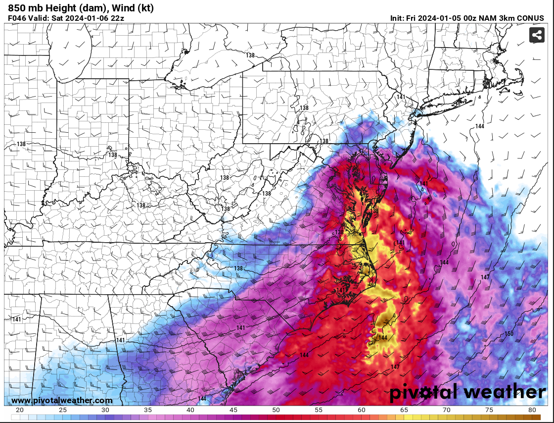
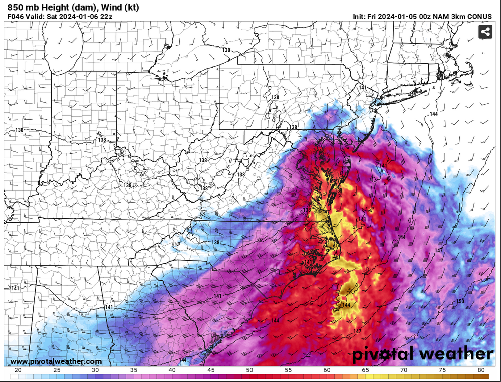
The reasoning for the shift in the colder solution on the NAM is the development of a closed 850mb low tracking south of the Potomac over north-central VA. Pay close attention to the wind barb across the northwest area and how the 850mb southeasterlies hit a brick wall over Parrs Ridge and the wind direction flips. This would allow for cold air to advect into the northern and western side of the circulation creating a more beneficial PBL and keep everything frozen, or even all snow. Check out the wind barbs to the east of RNK... As a result, watch the 850mb temp profile as we work through time. This is actually how you get surprises and periods of heavy snow when you weren't expecting. MAJOR CAVEAT.... THIS IS JUST ONE RUN OF ONE MODEL!!! We are going to want to see other guidance pull this off and have it become something to watch. This could be a one run and done deal, but there is potential for this. I will not be committing anything until I see some agreement from other guidance. It was interesting to see and point out as a possibility. It would affect the forecast in a big way. These are why these marginal events are so tricky. One thing can make or break a forecast. Let's hope it's right. Right now, no changes from my current thinking.

-
Well, been a fun few days for me. Good news, tested negative for Covid. Bad news is it’s still a tough URI to deal with. I haven’t had too much to add to what’s already been said. I’ll try to have a map out at some point. If not, I’ll list towns with my forecast and you can gauge from that. I like @Ellinwood map and would likely be very similar to mine, so you can use as a proxy.