

MillvilleWx
-
Posts
4,884 -
Joined
-
Last visited
Content Type
Profiles
Blogs
Forums
American Weather
Media Demo
Store
Gallery
Everything posted by MillvilleWx
-
 Ain’t no way I’m putting my luck out there lol. Whoever started the last one should do honors. Play the hot hand
 -
It’s an art. Even I’m impressed at the consistency all these years
-
@ravensrule
-
Southern MD / Lower Eastern Shore weather discussion
MillvilleWx replied to PrinceFrederickWx's topic in Mid Atlantic
No problem! It’s definitely possible, but narrowing exactly where that band could setup is tough and a nowcast situation. I think it’s plausible somewhere between south-central Jersey coast down to about OCMD extending to the western shore of the Bay. A lot of area and still a question mark. If I HAD to pick a spot, I like northern DE through northern MD along the M/D as the primary spot for something like that just based on trends and positioning of the upper jet. Will be watching intently along with the NWS because that’s the kind of stuff that can trigger a Hazard upgrade (WWA -> WSW). -
The HRRR couldn’t even get the storm right while it was happening earlier this week. I would ignore it until it gets a clue. Other hi-res and ECMWF are your best bets at the moment.
- 824 replies
-
- 14
-

-

-
One things for sure in this setup; it will start out cold and end cold. 20s for many for much of, if not the whole event. Wet bulb between 23-27 from north to south. 7H VV signals show decent ascent aligned with the LER of a prominent jet streak. There will be a 4-6 hr period of good snow rates that should accumulate efficiently. This is a textbook WWA event for everyone. WSW possible across areas north of I-70, but not impossible. Likely less than 20%, but that’s better than 0%. Heaviest snow should be within Frederick/Carroll/northern Baltimore Co/northern Harford, but don’t count out VA northern neck and WV Panhandle either. M/D line is favored right now, but as Bob mentioned earlier, someone will sneak a mini-jack outside the northern tier if the banding materializes.
- 824 replies
-
- 22
-
-
-
And to think it was wildly underdone for many on that map. A truly epic storm
-
Definitely agree. It’s just the historical trend that has occurred for you guys up that way. A little orographic assistance helps locally with ascent and ratios. Should be a winter wonderland in your area by tomorrow afternoon. Loving the trends this morning. This vort is pretty decent, so as long as it isn’t too far north, there’s some solid 7H VV’s and strong LER dynamics to work with. Probably see some scattered banding structures out of this one.
-
Hey guys. Thought I’d stop by and provide my forecast for the coming event. Looks like PA is solidly in my Zone D with a small piece in the Catoctins. Liking 3-5” for much of the subforum. Min of 2” and max of 7” in the highest elevations if everything broke right. Think 3-5” is a good call for the time being. Let’s freshen up this snow!
-
I like 3-5” for your hood at your elevation. I think people like you, @HighStakes @psuhoffman up there towards the M/D should do pretty well with this one! Be sure to add a max right over your house if you’re doing the Winter Desk
-
I think the average will be right around that 10-12:1, but I wouldn’t be surprised if the Parrs Ridge crew above 800’ and the Catoctins get closer to 14-15:1 overall. They seem to pull that in these types of setups. Not a crazy storm and one where the max is limited in potential, but snow on snow is always welcomed.
-
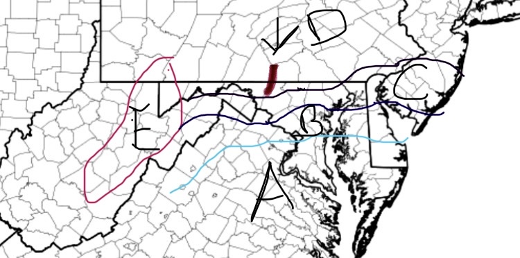
Thought this would be a good time to make a rudimentary snow map for ole times sake. Apologies for the crude map design. Doing this on my phone, but still works good enough. Each area is a zone with a first call forecast. Might have a few edits later, but this could very well be my only call. Forecast Zone A: Nothing-1” (Trace begins north of Potomac latitude); Up to 2” possible if everything breaks right Zone B: 1-2” w/ max to 3” if everything breaks right Zone C: 2-4” (Highest across Parrs Ridge; elevations >600’) Zone D: 2.5-5” w/ local max of 6” (Highest along the M/D Line and elevations >850’. Lowest in elevations <275’ in valleys) Zone E: 5-10” Catoctins: 4-6” w/ max to 7”
- 824 replies
-
- 13
-
-
-
20° at the top of the hill and 10° 1 mile away in a valley. Incredible
-
Jan 18-19 Storm Threat: Bob Chill made me do it
MillvilleWx replied to stormtracker's topic in Mid Atlantic
You guys are putting way too much time into a NS dominant system. Do yourself a favor and prepare for nothing and hope for more than that. I don’t waste my time with those evolutions in the Mid Atlantic. We aren’t New England. -
Jan 18-19 Storm Threat: Bob Chill made me do it
MillvilleWx replied to stormtracker's topic in Mid Atlantic
I imagine it holds or shifts the slightest bit north. It’s been consistent recently, which is great for my hood being consistently over 3”. Good dynamics should help with this one so long as the jet doesn’t cross north of us. -
Pretty neat microclimate in my part of Frederick. Low was only 17° this morning but the neighborhood across the way of Monocacy in a “bowl” got down to 12°. More decoupling occurring naturally at lower elevation. Fast forward to now and that same station is 3° warmer than my place (26 vs 23) so the elevation is again playing a role. It helps with snow as well being at over 310ft while places around me are 60-80 ft lower. Pretty cool
-
Jan 18-19 Storm Threat: Bob Chill made me do it
MillvilleWx replied to stormtracker's topic in Mid Atlantic
I have nothing to add right now that hasn’t already been said. I hate NS dominated systems, but this one has more potential than our usual nothing-burgers. General 1-3” with up to 4” in the hills and areas along and west of US15. ECMWF has been fairly firm on its depiction last succession of runs. QPF between 0.15-0.35 will be common with better lift through the aid of a strong mid-upper speed max cutting underneath. Should be in the left exit region of the jet for a period of time on Friday to generate good lift and nice dendrites before everything pushes out. Those looking for a bigger hit (6+”) should probably look elsewhere. This is missing some components for a bigger storm. The main component decided to rush out ahead of the primary vort which will negate full phasing or even more substantial interactions. Unless that slows down and the NS can catch it with short term trends, bar should be 5” or less everywhere.- 684 replies
-
- 16
-
-
-
Busy day! Just getting around to seeing this my man. Haven’t looked too closely at Friday, so I’ll reserve any comment until I get a better look at guidance. It does look like a close call for a moderate event in the LSV and around the Mason Dixon. Best opportunity is currently north. I’ll try to chime in tonight with more when I get a better handle. Today was a lot of running around and taking care of stuff, plus snow cleanup. Man, it actually was nice to be cleaning snow!!
-
Glad to see everyone cashed in on the storm. Looks like 3-5” was very common. Let’s smack another on Friday!
-
This was such a great storm for everyone. The lower density snow fall to coat everything. The rates were even solid for everyone at points. Everyone scored. Hell, we even got a flash flood event in Georgetown!
-
I slept more this morning and missed the additional snow so I’ll keep my total at 4.7” for the call. That period from 7-Midnight was the sweet spot. I agree. It was dumping for 2 hrs between 945-1145 that really piled up the accums. Had another wave between 1230 and when I took another measurement when it felt like a snow globe. Was in my element
-
Sounds about in line with my total. We had a few bands affect the north side of town last night that probably boosted us a bit compared to BC. Great storm for our hoods!
-
In MD, if you do it properly, every morning can be crunchy
-
4.7” with some compaction likely after I went to bed. A beautiful scene out there. Great storm
