

MillvilleWx
-
Posts
4,884 -
Joined
-
Last visited
Content Type
Profiles
Blogs
Forums
American Weather
Media Demo
Store
Gallery
Everything posted by MillvilleWx
-
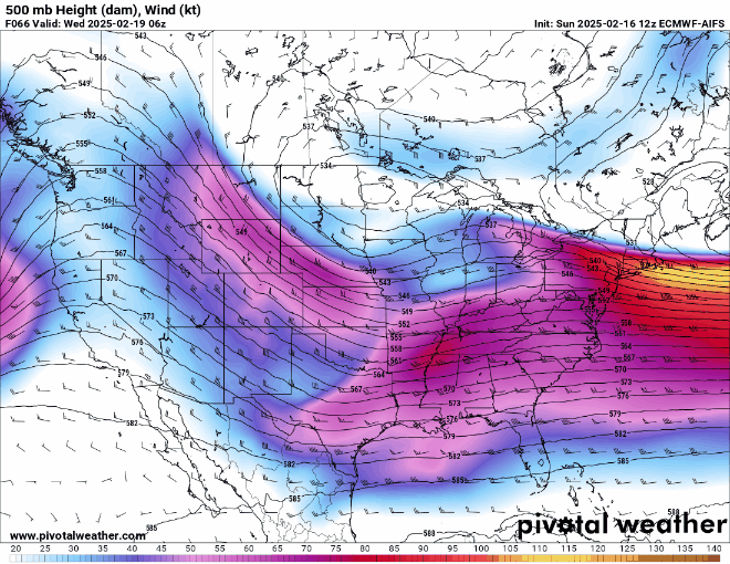
Was seeing this as well. Just gleaning over the thicknesses, you can easily see the flow being flatter this run downstream. This will likely lead to a restriction in the deeper moisture transport as upstream impacts will likely lead to less amplification of the wave as it enters the Tennessee Valley. This might be the firm beginning of the end unless we see things flip back inside 48 hrs. Not as likely, but never know.
-
This will be further south, but could very well get some snow throughout the area with decent totals where it’s being advertised on globals.
-
Edgewater with small hail and heavy rain to go along with some strong winds. Two solid lines today. Love the sound of the rain
-
All about latent heat release and general feedback. This type of storm is going to have some shifts up until 24 hrs out, me thinks
-
NAM12km aside, NAM Nest was pretty solid by the end of its run. Keep an eye to the northeast over the North Atlantic. That right there is going to be a huge player in latitudinal push for moisture transport, and it may open the door for better synoptic scale dynamics along the east coast. Everything is about spacing and the flow becoming more meridional upstream and all the different features play a role in it. At hr 60, you can see the differences at 5H and the handling of the trailing jet energy off New England. Also, take a look at the 5H ULL over the Upper Midwest. There’s feedback from what is going on downstream to how that will evolve. I don’t think we are over with interesting runs yet. Someone is going to blink. The NAM is most likely to blink when assessing historical trends, but it has led the way on occasion, so don’t put it past it just yet, especially the Nest version.
- 385 replies
-
- 12
-

-

-
You guessed it!
-
Cody is a great Met and great friend I work with at WPC. Something tells me it could trend a bit more NW in the grand scheme, but I still feel this is more for areas southeast of the fall line. We shall see how it all unfolds. I’m curious to see how the NAM Nest starts handling this thing once we get into range. I love the moisture feed with this thing on the S/S wave. The N/S just doesn’t want to play nice, but that is the hardest variable to solve traditionally for NWP. I’m not totally throwing any towels for areas east of Rt15
-
Line rolling through Edgewater area now. Dumping rain with water flowing down the street
-
Well, this continues the mantra I mentioned a few times yesterday about how delicate this setup is. There’s multiple ways to score, but also to fail and indentifying exactly how all pieces involved behave is going to take some more time before we can truly lock into something. The 00z ECMWF was a pause in the hemorrhaging that occurred the prior runs from other guidance. 06z kind of brought back the idea that was being entertained prior, so that signifies the delicate nature of the setup, as well as the 00z being more of a blip and not a trend. I do feel the best chance for a significant event is narrowing to east of the fall line all the way to the coast for our latitude. Further south into SW VA and @Bob Chill @Buddy1987 @wxdude64 land, the prospects for at least a solid WAA snowfall are increasing with every run. Should be a nice 850-700mb moisture transport into those areas with fresh arctic air in place. That’s a great spot to be in for at least something appreciable regardless of what transpires further downstream. Today will be another day I can see models deviating in either direction, so I’ll be taking these runs at less than face value and looking at the big picture. I figured 00z last night was the beginning of the end, but it was a small bump in the road and we’re right back to square one. NBM looked fine to my eyes. NAM (I know I know) looks like another way to score around here, so will be interesting to see if any other guidance shows a hand at that idea. I have my doubts, but NAM has scored coups before. It sniffed out the northern expansion of the 2016 blizzard into PA well before the globals did. Never know in this profession. Onward to 12z
-
The S/S vort will be in the CONUS late tomorrow into Monday. I don’t see that as the issue. The TPV evolution is the issue now. Too much separation with the waves and there’s nothing to bring it north. They all showed some interaction earlier which is why I wasn’t concern. Now it’s a mega flip to little wave interaction until it’s way too late. Tough break TPV interaction went the complete opposite direction. Favorable to potentially no interaction and more of a deterrent. We’ll see if this is a true flip or a weird blip. Definitely not what we want to see for the time being.
-
Nevermind….
-
Well, that went in complete reverse. TPV interaction went from partial to…”what interaction?” on the CMC. GFS trending backwards even more so for the S/S wave and interaction with the TPV is pretty awful. Now THAT is concerning. I’m not giving up hope, but man oh man, that is a step in the wrong direction to start the 00z suite. We’ll see what the UK and EC bring to the table because if they hold serve, then it’ll be a medium range model war. Damn
-
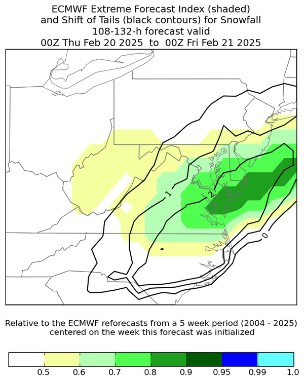
The 1987 storm was a huge hit for areas like Annapolis/Waldorf/Entire eastern shore. In fact, that storm is one of the top 10 all time snowfall over areas like Easton, I believe. This storm I feel has a lot of similarities and should be a more aggressive version of that one, if it materializes like some of the guidance infer. There is a strong push of deep layer moisture at 850-700mb on guidance right now with significant ascent within a period of pronounced 25H jet coupling. The ECMWF Extreme Forecast Index (EFI) signifies a pretty robust outline of very anomalous/extreme output within the envelope of possibilities. This is a sign for perhaps greater impacts extending back into the Piedmont with the strongest core of anomalies centered over the Eastern Shore, especially across the Lower ES. Now, this can shift if the synoptic pattern deviates from what is being forecast, but seeing that EFI (Shaded area) represent values >0.8 leads me to believe that we have ourselves a pretty significant output potential with this one and some indication of a further west and southwestward expanse of the heavy precip field.
-
That’s one of the more gawdy NBM runs at this lead you may ever see. To get that kind of result, you have to have some significant members within the blend, ensemble and deterministic. That is wild
-
Still haven’t seen anything that would make me feel on edge for the setup. I keep mentioning this….this is a delicate setup with the phasing and eventual interaction between the N/S vortex and the S/S wave that seems fairly robust considering the 5H anomalies. I don’t think some here understand how close some of these close runs were to blowing up into something greater. Yes, there is a chance the phase gets messy and things don’t turn as meridional as we want them to be, but the trend is for a significant storm to be present in-of ORF and the question becomes, “Where does it go from there?” Someone at this rate is going to get hit really good. The finer details and cohesion of guidance is still tbd. Don’t stress on every single model run. It is terrible for your health.
-
Hey y'all! Just popping in to say we might be staring down a big one potentially for next week. I am cautiously optimistic about areas east of Rt15 and south of I-78 for some significant snowfall potential. Still a ways to go and it's delicate, so stay vigilant, but I can't say I hate what I'm seeing right now in the overall pattern. Fingers crossed!
-
I don't put much stock in the ICON since it's a trash can model in the grand scheme, but I still look because there's nothing else new to parse over. Run was great for many, especially if you are east of Rt15. If you live out by 81, I can see SOME disdain, but even so, it's 11-13" so nothing to sneeze at. Also, if you are posting doom and gloom on a run before it finishes and it ends up being significant anyway, should be a key to stop doing any pbp and just enjoy others input. I did it for 6 years before I started doing any pbp and I'm a degreed met now. Sit back and learn, ask questions, and enjoy the meteorology of it all.
-
Blizzard Watches are no longer part of the Hazard issuances anymore. However, there are still Blizzard Warnings, but there is just a Winter Storm Watch issued with Blizzard wording. This is part of the Hazard Simplification that has been occurring the past 6+ years. This is also the case with Ice Storms where there are no more Ice Storm Watches, but there are Ice Storm Warnings.
-
So long as there is N/S interaction with the strong S/S vort, there will be a decent swath of heavy snow with formidable totals. That much is coming to light. The overall interaction when those two rendezvous will be the difference between a widespread MECS or a HECS that rivals some of the bigger storms in our history. So far the threat looks to be gaining traction, but this is still a very delicate balance. There's still time for changes in either direction. I can't complain about what has been shown on today's runs. UKMET is the only type of storm that would have significant low-level thermal issues that could skunk some of the forum. Until more guidance shows that, I'm not sweating it.
-
Going to stock up on the hearty ingredients for stews and pot roasts as well. Weather that will keep you parked calls for good, hearty nourishment. Time for pancakes and pot roasts!
-
Welp, it might be time to start really paying close attention to this one ladies and gents. Still not etched in stone, but Donatello is probably getting his tools ready
-
That sentence reminds me of those days in High School when you had to submit a paper with AT LEAST a certain amount of words for it to count. You do anything you can!
-
ECMWF was a thing of beauty in all phases. The crazy thing is.... that's not even the max scenario of it all when you assess how 5H evolves. Pretty insane. GFS I feel is up to its progressive bias of it all. ICON and GFS are usually too fast with these types evolutions and you can tell because they have similar issues. Compared to the rest of the suite, they were near misses to something much greater. Can't hate that 12z suite. The big ones are always a tight rope walk because EVERYTHING has to go right to get a monster result. Block up north helps in these scenarios. Now....we wait.
-
Hey guys! Been busy...I miss anything?
-
I'm certainly intrigued by next week. Another fun week of tracking possible. I've been slammed at work with this next bomb eastern half of the CONUS, so I look forward to recaps once I get off work. Let's hope for a solid 12z


