MillvilleWx
-
Posts
4,884 -
Joined
-
Last visited
Content Type
Profiles
Blogs
Forums
American Weather
Media Demo
Store
Gallery
Everything posted by MillvilleWx
-
Man, even a slight north shift would be epic for the DC area. Amazing run
-
5H and 7H over KY moving east look very tasty. That should be some good stuff between 00-09z Tuesday
-
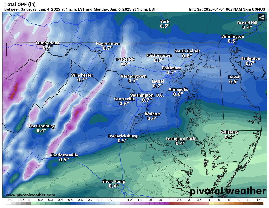
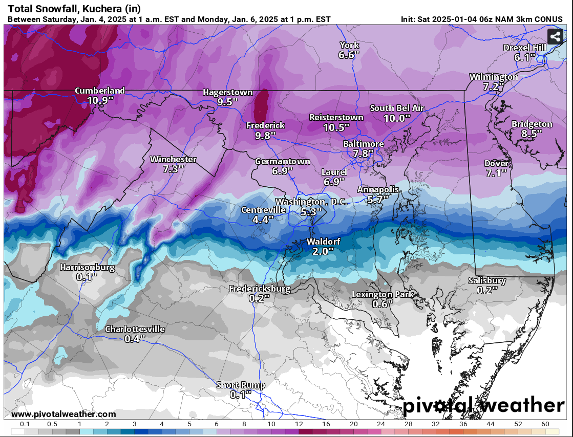
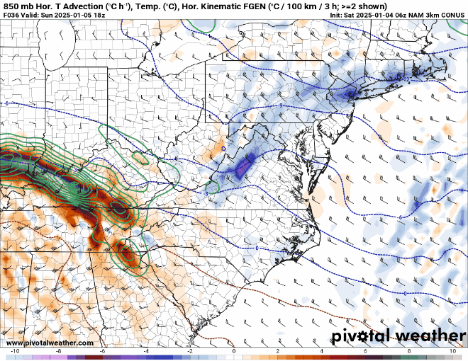
Last but not least, some precip panels from the 06z NAM Nest Total QPF thru 18z Monday (Still more storm left!) Kuchera Snowfall thru 18z Monday

-
Both are useful! There's some 7H FGEN in there as well but the 85H was just incredibly impressive, so wanted to share.
-
Pretty incredible beat down for many in here. Even a slight south shift would pay dividends. Incredible that there is still more storm left with the trough back in KY
-
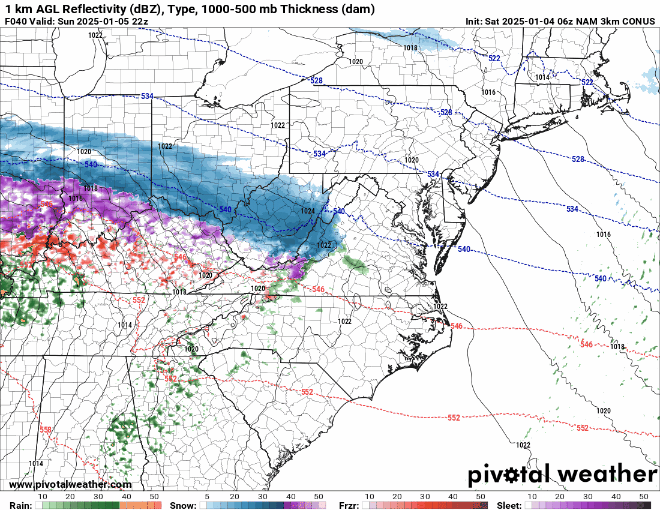
850mb FGEN on the 06z Nam Nest
-
There's notable difference in the handling of the thermals by the NAM Nest and the parent 12km. The Nest does a good job with the physical nature of evaporative cooling in the column when heavier precip moves overhead as the soundings between 850-750 drop to isothermal or colder, maintaining snow for longer periods of time. Only when the precip starts to lighten up the afternoon a touch does the thermal profile become more favorable for IP chances. Even so, the areal extent does not get much further than US50 in MD to DC and stays mostly snow in the Northern neck of VA. The second part of the storm is still to go as well on the Nest since it only goes out to 18z Mon and the trough is still all the way back into KY. It's a pretty formidable shortwave, so a pass underneath would likely spark the second round of precip which would be higher ratio fluff before exiting the area. You can tack on 1-4" with that feature alone bringing totals to 6-10" between I-66 to I-70, then along and north of I-70, totals would be 8-12" with local to 15" most likely, verbatim. This run was similar to my thoughts on how this storm might play out with multiple banding features across the region. The 85H FGEN panels are sick and would likely allow for one hell of a scene on Monday morning in these parts. Of course, will have to see how the runs hold, but this is a time frame to now take interest in the Nest. Yes it's at range, but this model has a history of scoping out thermal progressions in these setups and has the resolution to fine tune these types of details as we get closer to game time. A slight south adjustment would still make almost everyone in here happy to some degree. Good run
-
I was on the collaboration call and you would be correct haha
-
Watches will be posted overnight by offices in the Mid Atlantic. You'll see them in the morning when you wake
-
Mitch, I've been looking at cluster analysis since the 00z came in and the grand ensemble has you at 4.5" and the top two clusters have you at 5", and that's with a rudimentary 10:1 ratio across the board. I think you'll see 4-8" at this juncture, but we'll see how it all plays out.
-
Yup! DE really gets the goods on any run that gets the CCB going. Nice high ratio fluff to round it all out.
-
Loved that place growing up!
-
Back over the summer. Bit closer to work and a little better living arrangement (Personal stuff). Wife and I might be settling in Northern AA or out by Mt Airy in 2026. That's the goal. Financially will be considerably better by then with student loans and car payments all paid off. Amazing how much money that will open up. Btw, I grew up less than 12 min from you. Carney/Cub Hill area. I lived off Northwind and Harford Rd. Loved that area. Was a neat little microclimate outside the Beltway.
-
Cautiously optimistic for us lowlanders. Edgewater/Annapolis is consistently on the northern fringe of the IP line. One thing I do love seeing is consistency on the CCB pull through for here. If that materializes....we will get raked before the storm bids, "Au Revoir!" on its way out. One of the reasons we see the 2-4" uptick for Eastern AA Co. Fingers crossed!
-
Ah yes, EMC! I keep forgetting about them. They are literally two floors down, but they just go about their business and are quite reserved. Super knowledgeable people down there at NCWCP. Appreciate the response
-
FV3 at the end of the run, so take it for what it's worth, but considering the antecedent airmass and wet bulb temps, there's a good possibility many of us are snowing early Monday morning between 22-26F with DCA probably reporting 28-29. In any case, surface temps look really solid to stay at or below freezing for many in here.
-
I believe the GFS runs on the FV3 core and is fairly hi-res compared to what it used to be. RGEM runs at a resolution similar to the NAM with the HRDPS the Canadian version of the hi-res 2.5km, although it has some significant issues with a multitude of parameters. This is a great question for the MDL people since they have more of the background.
-
Under no circumstances would I have put out a map that looks like that with those ranges. I've made these decisions before for these types of maps. This is honestly a no-no. Ugh
-
70kt 85H LLJ aimed right at them doing the trick. System is still very dynamic in its structure.
-
Storm looks healthy so far via the 00z NAM. Man, NE Kansas is going to get the business with this storm. Sheesh.
-
Yup! This is the stage where if we see any deviations from the norm, it would be now with the introduction of the CAMs. The D3-5 period is pretty boring typically on the NBM with regards to changes, I've noticed unless there is a noticeable shift in the general synoptics. So far nothing shows that at this lead. Appreciate taking the top to pop in and give some low down on the model background part of things @high risk I try my best, but you and @dtk are more well versed than I on the inner workings of most, if not all relevant NWP.
-
1/3/25: 0.3" - Snow squall that lasted 10 minutes. Non-accumulating snow prior and just after. Snowed for an additional 30 minutes afterwards, but little to no accumulation.
-
The NBM is a very useful tool for forecasting when you know how to interpret it and understand its biases. I've been keeping an eye on it and it's been pretty great with handling the swings and limiting the crazy max/min variance from run to run the past few days. It'll be interesting once the CAMs start getting incorporated. That will be a useful way to seeing some of the proposed banding being forecast.
-
Most of the snow occurred here in a 10 min burst. A nice little appetizer before Monday’s main course.
-
0.3” here in Edgewater. Was having dinner with the wife in Annapolis and it was raging for a period. Everything solidly covered.