

Cold Rain
-
Posts
23,935 -
Joined
-
Last visited
Content Type
Profiles
Blogs
Forums
American Weather
Media Demo
Store
Gallery
Everything posted by Cold Rain
-
They would have to do a complete 180 for what to happen? All rain? Not sure anyone is calling for that. It’s hard for me to believe that you have been following the weather for as long as you have and have as much faith in 5 day snow maps as you do, regardless of their consistency.
-
Go to West Jefferson. It’s awesome.
-
It might go ENE for one more frame. I guess we'll never know.
-
I've lived here a long time! We'll check back in on Tuesday and see how I did.
-
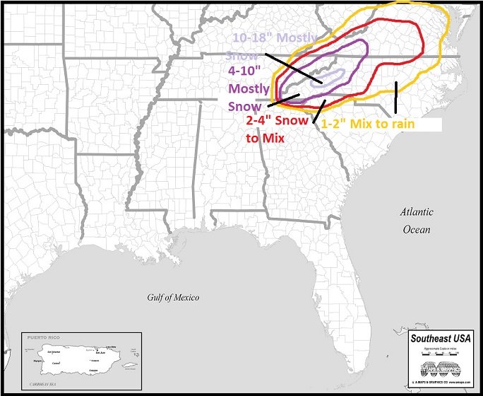
Here's my final call. Ignore areas outside of NC. Just drew a continuous area for symmetry, such that it is.
-
It may prove me wrong this time, but I hate the Canadian model. It has been way north the whole time and is now correcting south. It's just not very good. I'm sure its solution is within the realm of possibility, but I still don't like it.
-
Thanks for posting this. I'm I wasn't out in left field with thinking that. I still think the Pac wave comes onshore a bit stronger than modeled. We'll see.
-
I said this on the other board, but I've seen these waves coming in off the Pacific show up in the mid-range weak, many times, only to end up verifying stronger when they come ashore. I think it has to do with sampling. We'll know pretty soon, but that is going to make a difference, IMO. Also, I'm wondering if the waves dropping in from up north (strengthening the HP and interacting with the southern stream) are not well sampled yet either? All of that should be resolved soon, if they are even issues currently.
-
Yep, that is definitely going to be key here. Every little bit will help.
-
They're not really. We just aren't getting in on the big snow totals. There is still a good shot at a winter storm here. It will likely be mixy, but that's to be expected, honestly. If we have a CAD situation like it looks like now, it will overperform.
-
Nah.
-
Euro control run. It basically has 10+ totals over Wake. More west. Regular Euro kills us with WAA.
-
Maybe picking up on damming better?
-
Awesome. Thanks! Yep, sucks for us. But pretty typical.
-
Thanks. It'll be interesting to see how far east it gets with the snow line. I expect the precip will be farther north than that. I'm much more concerned about the cold air.
-
Anyone got the UK snow map?
-
I feel like a lot of times, the models underestimate the strength of waves coming ashore from the Pacific, due to the lack of data in the region. The often tend to verify stronger when they move ashore, which may have implications down the road.
-
The placement of features is about as good as it gets for the upper SE. Unfortunately, as ILM said, the air mass isn't extremely cold. That's fine, if everything is perfectly timed. Just cold enough is still cold enough for snow, just like extreme cold is cold enough for snow. The issue is, you have less room for error when temps are 1 degree below freezing at key levels. Also, those highs are pretty weak. When you're dealing with marginal cold, you need all the help you can get from a strong high pressure. Hopefully, the timing can work out. Anyway, I like the placement of the key features. And I stick with my motto of getting cold first, then worrying about precip.
-
We want to see strengthening high pressure as we move in. Not the typical weakening.
-
That's pretty amazing. I have never seen snow like that in person. Your pic is one of the snowiest pics I've seen. I'll bet that was so fun.
-
What would you guess the rate to be in that first pic? Looks like about 3"/hr at least.
-
Sure, if it's showing snow. Otherwise, it's a horrible model, and I would suggest tossing it!
-
Its snow maps have an established track record of sucking. But it's skill seems better than the regular GFS, overall. Honestly, there are too many factors for any model to have a lot of skill at this lead. Best course at this point is to look at the range of possibilities, compare to analogs, and blend in climo. A good winter storm is possible, but we need to observe trends over the next 3 days or so before we can legitimately hone in on who gets what.
-
I’ll take my few sleet pellets and extensive rain cold and like it!
-
No sir. GOA low bad. Fast Pac jet slamming right into the NW coast. Floodgates open for mild Pacific air. A better feature is the Aleutian Low.


