poolz1
-
Posts
2,694 -
Joined
-
Last visited
Content Type
Profiles
Blogs
Forums
American Weather
Media Demo
Store
Gallery
Everything posted by poolz1
-
12/15 - .75" 1/6 - 4.5" Season Total - 5.25"
-
4.5" snow. Melted down to .45" liquid. Exactly 10:1. My guess is the WAA snow was slightly less than 10:1 and the last 1.25" of snow was probably 12-15:1. Lots of fine flakes with the WAA.
-
First hvy snow of the event! 3.75" so far. 25/23
-
We typically have some type of high pressure to our north during these WAA thumps. Whether its sliding east or just a weak GL high. I wonder if the lack of the typical banding we'd expect was due to this?
-
Fine flakes just starting. 27/13
-
6" is my bar for this one. But, nice to see NWS comfortable with 8-12. No complaints!
-
For the northern counties...PSU has been all over it but Ive been watching the mesos for how they handle the time between the WAA and the passage of the upper low. Would be nice to keep cold powder going throughout the day and avoid the lull. LR hrrrrrrr so... but it has been slowly looking better for midday. We'll see how it trends.
-
Got my first Davis in 2009 and just replaced it this year. I really dug into whether I wanted to change from Davis but decided stick with it and happy I did. The new console and Weatherlink are really nice. Great having data stored on the cloud and easily referenced from anywhere.
-
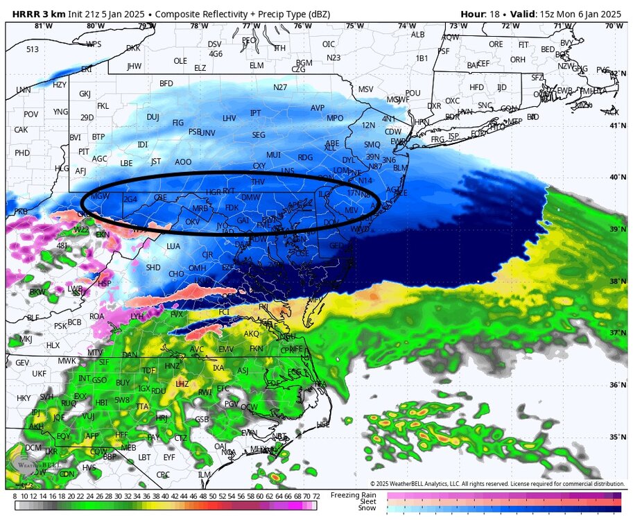
Lock in that 3k right now. The trajectory of the ULL snows looks great for the entire forum. Turns a 6-8+ storm into an areawide 8-12.
-
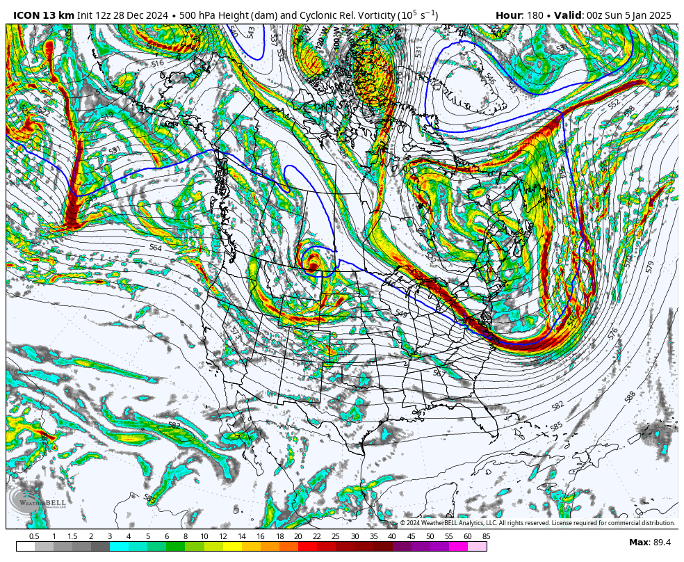
That is one amped system at h5. Damn
-
So expect blizzard conditions imby, got it! What a great storm that was.
-
Question...how would it affect things, if much at all, if the wave never opens up and remains closed as it passes to our south. The prolonged period of snow after the main WAA seemed better this run. I noticed that after opening up in SW VA it does close off again in SC VA. Is this the reason for a better ending to the show?
-
January: Medium/ Long Range: May the Force be with Us....
poolz1 replied to Weather Will's topic in Mid Atlantic
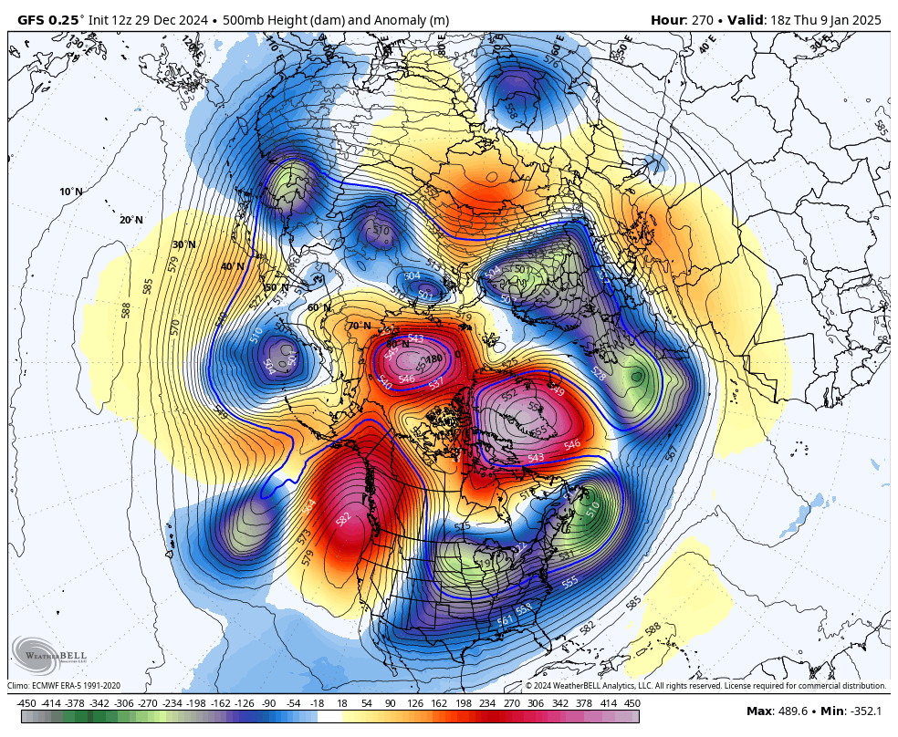
I know we are laser focused on the 6th and for good reason but starting to get good vibes for the uber LR. The end of all 3 ens today show a very nice pattern with a stretched PV that's in a good position, GL block becoming established again and heights rising in AK. I remember about a week or 10 days ago thinking around the 17th the pattern would start to break down based on the weeklies.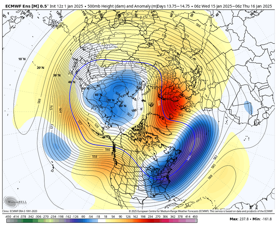
-
January: Medium/ Long Range: May the Force be with Us....
poolz1 replied to Weather Will's topic in Mid Atlantic
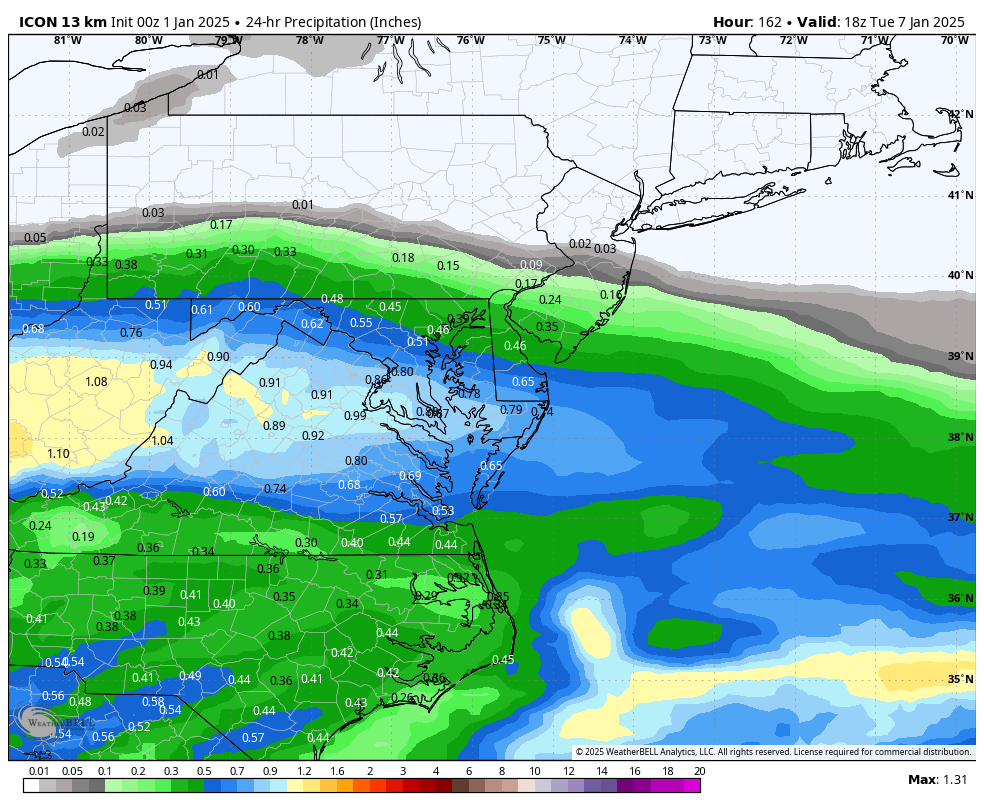
Our bread and butter precip stripe. Now just nudge north and juice up!
-
January: Medium/ Long Range: May the Force be with Us....
poolz1 replied to Weather Will's topic in Mid Atlantic
Doesn't work this time but the ceiling is about as high as it gets with that look. Plenty of blocking but with so much ns energy being thrown around this doesn't look like a long track pattern. Big storm may not be consistent until D3-5 -
January: Medium/ Long Range: May the Force be with Us....
poolz1 replied to Weather Will's topic in Mid Atlantic
What an epic look. Good lord!
-
January: Medium/ Long Range: May the Force be with Us....
poolz1 replied to Weather Will's topic in Mid Atlantic
We should be seeing eye candy like this with the advertised pattern. About time. -
January: Medium/ Long Range: May the Force be with Us....
poolz1 replied to Weather Will's topic in Mid Atlantic
Its the one after the one after. -
January: Medium/ Long Range: May the Force be with Us....
poolz1 replied to Weather Will's topic in Mid Atlantic
Not a bad look from the 12z icon at the end of the run. Maybe setting up a front end thump type deal for the 6/7th.
-
January: Medium/ Long Range: May the Force be with Us....
poolz1 replied to Weather Will's topic in Mid Atlantic
I'll take historic cold if it comes as advertised by the 0z euro. Most likely an areawide blanket of snow from 1-2 events and likely more opportunities as the vortex lifts NE. The end of the euro op was a wild look. -
January: Medium/ Long Range: May the Force be with Us....
poolz1 replied to Weather Will's topic in Mid Atlantic
Seems the trend on the ops and ens at 12z is to improve the Atlantic during the 1/6-8 period. -
January: Medium/ Long Range: May the Force be with Us....
poolz1 replied to Weather Will's topic in Mid Atlantic
6z GEFS really honking this run for the 3-5th window. Just playing follow the leader? Big difference from 0z.
-
January: Medium/ Long Range: May the Force be with Us....
poolz1 replied to Weather Will's topic in Mid Atlantic
Just move on to the next op run. What are you new at this? -
January: Medium/ Long Range: May the Force be with Us....
poolz1 replied to Weather Will's topic in Mid Atlantic
Adreed. With as many op runs we see in a 24hr period I would think there would be a signal. Even if its scattershot. I remember the same thing last year. Beautiful h5 maps in the lr but we couldn't score even digital snow on the op runs. -
January: Medium/ Long Range: May the Force be with Us....
poolz1 replied to Weather Will's topic in Mid Atlantic
I know ops are just for entertainment purposes in the 10-15 but I do like to see potential on them....even in the LR.