poolz1
-
Posts
2,694 -
Joined
-
Last visited
Content Type
Profiles
Blogs
Forums
American Weather
Media Demo
Store
Gallery
Everything posted by poolz1
-
GFS has a pretty dry airmass overhead... dews in the upper 10's - low 20's on Monday morning. Euro kicks everything just a bit N. Wish I could say I trust the GFS but it seems like the euro has been winning this midrange battle with systems here lately.
-
Maybe a decent window of opportunity starting 1/1. All 3 global ens with a cold push during this timeframe along with waves running the boundary to our south. Finally, a precip signal that is lining up with some colder temps.
-
.12" last night. Just went back and looked at my records for this fall. Since Nov 1st only 1.11" has fallen here...including last nights rain. Somehow the dog still tracks mud in the house daily.
-
December 2021 Medium/Long Range Discussion Thread
poolz1 replied to North Balti Zen's topic in Mid Atlantic
I definitely hear what you are saying. But, the pattern is changing right on top of us. It was just 2 weeks ago or so that people were noting how "all the wrong colors are in all the wrong places." The ball of blue over AK and the all of the HLB locations. There are definitely faults to the advertised pattern but we are gnat's hair away from a very nice set up. We aren't yet in the game but the coach has us by the jersey and is ready to put us in! But hey, two weeks we weren't even in the stadium. Personally, just a little help out west would be best. If we get a full on ++PNA that links up over the top the PV will be sitting over Lake Erie....especially with the strength of the west based block. A slow transition that ebbs and flows would be nice. -
December 2021 Medium/Long Range Discussion Thread
poolz1 replied to North Balti Zen's topic in Mid Atlantic
12z euro ens show the western trough weakening toward the end of the run with the 50/50ish trough becoming dominant. West based block still going strong.... -
December 2021 Medium/Long Range Discussion Thread
poolz1 replied to North Balti Zen's topic in Mid Atlantic
I was just thinking that it looks like we may have a false start to this pattern next week, warm up a bit for the holidays (of course) and then the pattern becomes better established. -
December 2021 Medium/Long Range Discussion Thread
poolz1 replied to North Balti Zen's topic in Mid Atlantic
That is one impressive -NAO signal toward the end of the month for an ensemble mean. -
December 2021 Medium/Long Range Discussion Thread
poolz1 replied to North Balti Zen's topic in Mid Atlantic
That is the way I remember it looking. Cold smoke with a crazy gradient to our south and an endless moisture stream from the SW. One can dream... -
December 2021 Medium/Long Range Discussion Thread
poolz1 replied to North Balti Zen's topic in Mid Atlantic
My memory is terrible when it comes to past patterns and even minor/mod events. But, that fantasy overrunning event depicted on the models was droll worthy and is etched in my memory. Would love to see an event like that really unfold. For folks with better memories, what past event looked most like that fantasy set up? -
December 2021 Medium/Long Range Discussion Thread
poolz1 replied to North Balti Zen's topic in Mid Atlantic
Phase 8 with decent amplitude....GEFS should continue to look decent toward the end of the run. Euro with the same look but just a little delayed by a day or two.
-
December 2021 Medium/Long Range Discussion Thread
poolz1 replied to North Balti Zen's topic in Mid Atlantic
0z GEFS with the trough finally east of the HI islands and a trough retrograding into the NE. Out there at the end of the run...so, grain of salt for now. You can see a very nice pattern setting up in the D15-20 if that progression continued. -
December 2021 Medium/Long Range Discussion Thread
poolz1 replied to North Balti Zen's topic in Mid Atlantic
I agree....but at least over the past few weeks it seems like the GEFS have had a better handle on the LR than the EPS. Just an observation but it wasn't too long ago the EPS was steadfast on a nice +PNA for early Dec and the GEFS wanted no part in it. A consensus inside 10 days on a workable pattern sure would be nice. -
December 2021 Medium/Long Range Discussion Thread
poolz1 replied to North Balti Zen's topic in Mid Atlantic
I have been waiting to see some fantasy op runs that start to point to a -NAO developing in that timeframe. As you know, these -NAO episodes are rarely picked up on in the long range but once inside D10-12 you can start to see glimpses on op runs and on the ens to a certain extent. 18z thru the 06z run this morning all featured a robust + hight atom moving into GL. The first runs I have seen in a while and it has been 3 in row (4 if you count the 12z run yesterday). But still...like you said, we just can't know yet! Hey, maybe we can get a nice block just before the holidays that produces like the 06z run.... -
Saw that as well. Same thing on the radar out of Pitt around the same time. Thinking birds myself...
-
December 2021 Medium/Long Range Discussion Thread
poolz1 replied to North Balti Zen's topic in Mid Atlantic
18z GEFS is probably too quick with the progression, or just plain wrong. But the end of the run shows the beginning of what you just described. A hint of lower heights pushing toward the 50/50 region while the ridge begins to redevelop westward into GL. A little washed but definitely some members seeing it. Would be nice to see a decent pattern setting up for late Dec. Just in time for prime climo. -
December 2021 Medium/Long Range Discussion Thread
poolz1 replied to North Balti Zen's topic in Mid Atlantic
EPS really honking the scan ridging in the LR.
-
December 2021 Medium/Long Range Discussion Thread
poolz1 replied to North Balti Zen's topic in Mid Atlantic
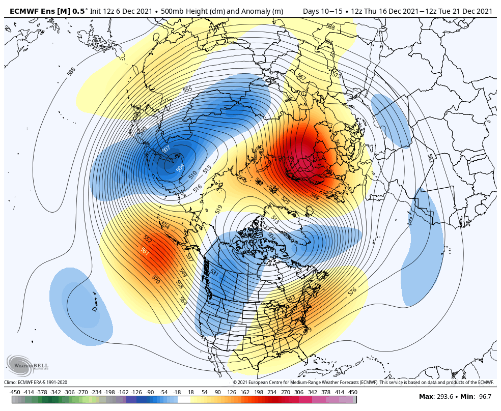
The one consistent theme in the LR is the Aleutian ridge and the Barents/Kara Sea ridge. Both are poised to squeeze the PV into NA if tropical forcing can cooperate for a time and allow the PAC ridge to go poleward. Wishful thinking? Absolutely! I will remain optimistic and hopeful...why? Because if it doesn't snow life will still go on. Though, I will admit this place can beat you down with negativity... -
Maybe some coatings late tonight/early am...
-
December 2021 Medium/Long Range Discussion Thread
poolz1 replied to North Balti Zen's topic in Mid Atlantic
As Wentz said, that transitory +PNA is key. Ops are jumping around with it's placement but the signal is there for a ridge to pop. Ens are showing it as well but are just a little washed...plenty of uncertainty on placement, strength and orientation. Some interesting ingredients are there. Plenty of Arctic air ready to be tapped just prior to any ridging going up. -
Can you still post pics from a link from sites like imgur? I have had no success with trying to post links to pics or gifs. I only have the option for posting the site restriction of .00000000001MB
-
Broke into the teens for the first time. 19.4 for the low.
-
Well, if the eps is correct towards the end of the run (big if) this may be a fun ride after turkey day! Cross polar flow, with still a nice GL blocking signal.
-
Euro ens again trying to pull the trough back in the west and create a real deal winter pattern as we close out Nov. Seems like something shifted overnight with both GEFS (as CAPE posted) and the euro looking better in the LR. Maybe MJO related?
-
That sounds outstanding. I have been advocating for a beach Thanksgiving for years....but, you know family traditions die hard and I have been voted down each time.