Boston Bulldog
-
Posts
619 -
Joined
-
Last visited
Content Type
Profiles
Blogs
Forums
American Weather
Media Demo
Store
Gallery
Everything posted by Boston Bulldog
-
 Coming down at a decent clip here in the UES, streets slushy, avenues wet. I am a bit concerned about Manhattan getting stuck in between the deformation band over NNJ and the WCB goods pushing into Long Island. Mesoscale analysis does have me optimistic that subsidence shouldn't be too much of a problem however, as it really isn't consolidated over a pivoting band to our northwest. Right on cue some bands are infilling just over the Hudson in Jersey, so at this hour there doesn't appear to be a deformation mega band to the west that will have the city dealing with bright clouds and exhaust. There will be consolidation at some point with these bands as the fronto gets cranking, still question of where this will happen who will get the pivot point.
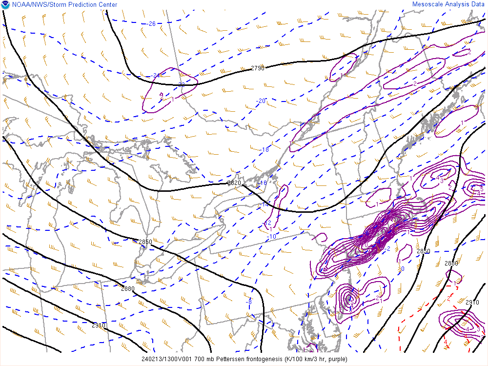
-
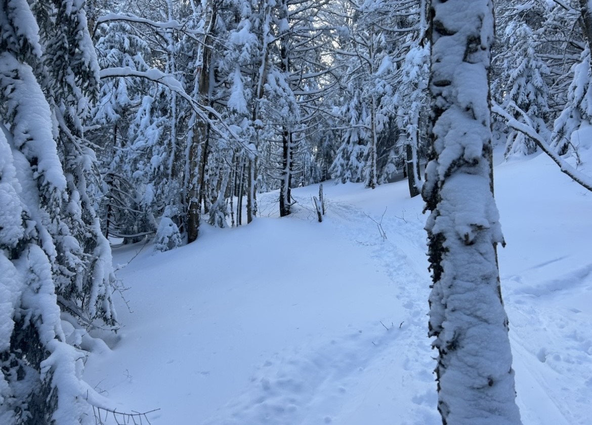
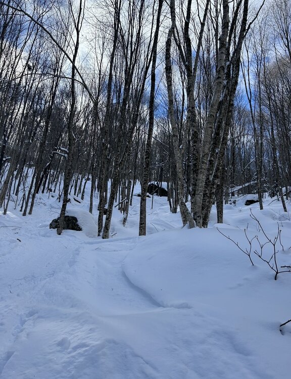
Sampled the goods across multiple spots in Central and Northern VT over recent days. There is a bit of a gradient in snow conditions between the haves and have nots to this point in terms of both rain avoidance and upslope production. Burke had soft snow with a few inches of fluff on top of a hard packed (but not very crusty) surface. Seems as though they were just far enough north and east to mitigate rain crust from the cutters earlier in the month. Despite this, the base wasn't particularly deep as they failed to cash in on the upslope bonanza of this past week. Smuggs was fantastic. Deep base, minimal crust, and tons of fluff. The northern spine is in amazing shape, can only imagine how great Jay is skiing right now. Wrapped up the north country swing with a chilly tour up two different zones at Brandon Gap. Given the more southern location, a more prominent rain crust was lying anywhere from 3 to 10 (in drifts) inches below the fluff. Certainly more soft stuff on top than at Burke due to upslope, but in general conditions at Brandon were more variable than elsewhere. Still lots of fun turns to be had, though the lighter touring skis did struggle a bit with the crud Overall, great conditions for mid-January. A few shots from Brandon today:

-
You nailed it earlier this week regarding the upslope look. Looks like the spine from Stowe to Jay got blitzed last night
-
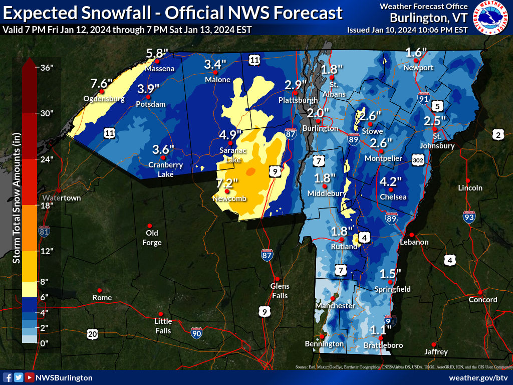
Initial offerings from BTV for this weekend are a bit more paltry than the last storm. There does appear to be a significantly better upslope setup than what we are experiencing right now, so accumulation should continue in favored zones beyond this point on Sunday.

-
1/9-1/10 Now Morphing to Less-Than-Exciting Power Cutter
Boston Bulldog replied to Torch Tiger's topic in New England
Ha, this is essentially a topographic map. You can clearly make out the individual ranges within the High Peaks region of the ADK, the spine of the Greens is lit up, and even Mount Ascutney is clearly visible just W of the CT river. Mount Sunapee, Mount Cardigan and Kearsarge are also very obvious as well. Even some key passes and valleys in N-VT are clearly visible. -
1/9-1/10 Now Morphing to Less-Than-Exciting Power Cutter
Boston Bulldog replied to Torch Tiger's topic in New England
Definite over-performer in VT. Very similar look to the 90th percentile map from BTV last night -
Agreed regarding the 19th. If the ridge indeed builds to the modeled amplitude over the West, it’s reasonable to conclude that the downstream response has lots of room to dig deeper and orient into a more favorable position for redevelopment. Based on 12z OP runs, we would need the ridge axis to split the difference between GFS and Euro positioning to open the door to something bigger.
-
1/9-1/10 Now Morphing to Less-Than-Exciting Power Cutter
Boston Bulldog replied to Torch Tiger's topic in New England
https://operations.nysmesonet.org/~nbassill/loop/index.php?map=WINTER Some big gusts showing up on the NYS Mesonet just west of the Tug Hill. Pretty big numbers being put up over the Finger Lakes region and Southern Tier as well. -
Sugarbush and MRG are about to get blasted. Would have to think VT-17 across the App Gap is a ridiculously difficult drive right now
-
18z GFS coming in 2mb weaker at 72h over Illinois. No change in surface high intensity over QC
-
Two Mdt to high impact events NYC subforum; wknd Jan 6-7 Incl OBS, and mid week Jan 9-10 (incl OBS). Total water equiv by 00z/11 general 2", possibly 6" includes snow-ice mainly interior. RVR flood potential increases Jan 10 and beyond. Damaging wind.
Boston Bulldog replied to wdrag's topic in New York City Metro
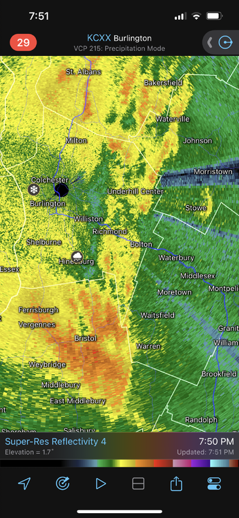
Coming down pretty nicely in UES, correlation coefficient suggests the mix line is about to reach the southern extent of Staten Island -
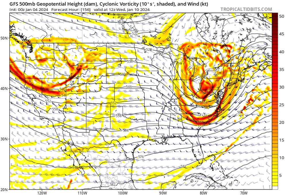
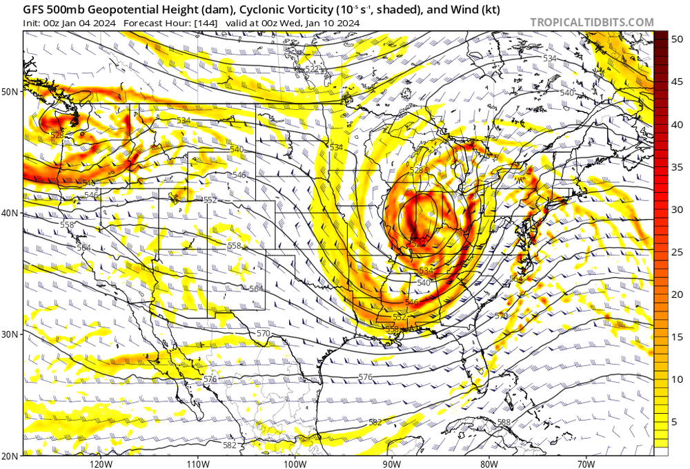
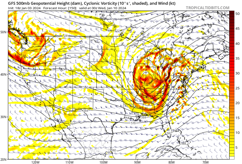
Now look at how the different handling of vorticity changes the trough orientation 12 hours later. No wonder 0z pops to the coast.

-
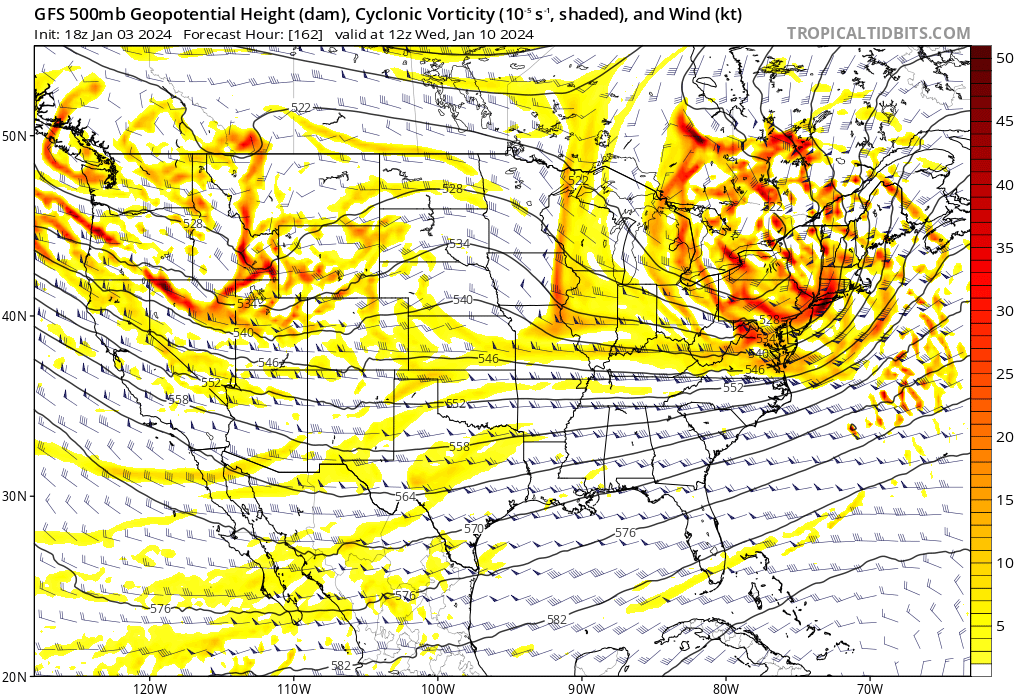
Big differences at 500mb with shear vorticity over the plains
-
500mb trough takes longer to go negative for the 0z run than in 18z. Lobe of shear vorticity over the plains seems to be trailing more at 0z rather than getting wrapped up as much.
-
7mb weaker through the lakes at 150hr and as such a much more substantial coastal reflection forms, with a transfer to GOM by 162hr
-
There is a reason why there is so much concern about convection ruining phasing dynamics in some potential high end bombs off the coast. Threading the needle isn't easy. This setup seems "messy" enough that boring background dynamics should win the day and get this thing up the coast without convective issues.
-
Considering the first wave is fizzling out and the secondary wave is what provides the primary forcing, I wouldn't be too concerned about that occurring. Not like there is a deep cyclonic center that is getting shunted east by the convection, the synoptic sweet spot downstream of the second wave will win out at the surface in this look even if the convection does some wonky things early in the evolution.
-
Closed surface contours making landfall on the Florida Big Bend. Obviously lowest pressures jump north in the next frame, but the GFS seems to be really struggling with the convection down south.
-
“Pieces are on the board” now so to speak, but one or two runs with enhanced data doesn’t mean a solution is suddenly locked in. Sampling isn’t a silver bullet by any means, just better information. Need wait and see how the models trend with all of this new data being assimilated. I threw out 0z tonight as being a rough time when the repercussions from this new information would become evident over a few model cycles. We have seen more run to run continuity today so far
-
Recent GFS outputs seem to have some substantial convective interference with the SLP track as it traverses southern AL, MS and GA. I don’t see any other guidance with the SLP being pulled so far south by convection. EDIT: Looking into this, seems to first surface at the 18Z run yesterday
-
Fantastic overview, the final graphic reminded me of some shown to my class during a video in our Atmospheric Physics unit on turbulence. Honestly I only remember that video, not because of the examples and graphics shown, but because of how the professor was constantly lighting his pipe during the lesson. Hard to beat that introduction at 0:45. What a legend
-
Would be foolish to lock in any sort of solution until we see how the trough digs over the W-US and interacts with the surrounding dynamics. The models are having a difficult time placing and orienting the shear vorticity feature behind the trough, which has a direct impact on synoptic scale forcing for our cyclone. It's an age old adage, but once the SW hits the west coast, improved sampling at the upper levels should lead to a decisive move. While I'm not saying throw out tomorrow's guidance, I would expect a distinct trend that emerges around 0z tomorrow night to be the fate of the system.
-
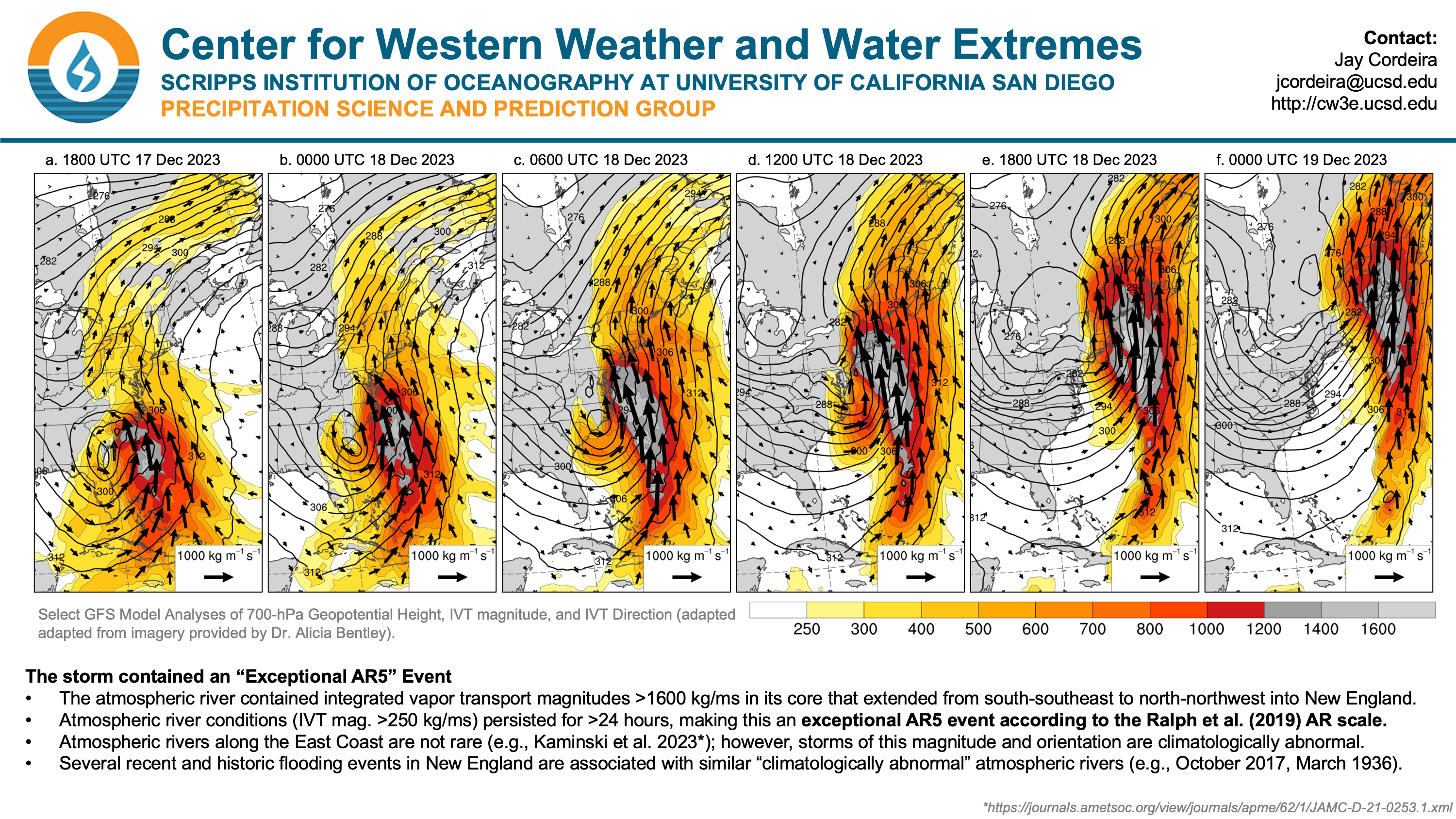
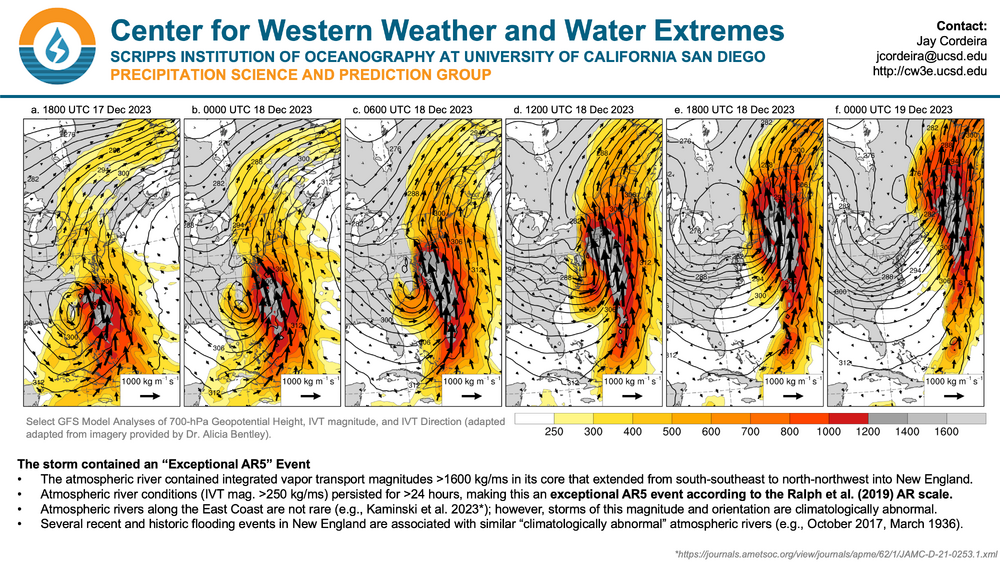
For posterity's sake. Wow. Dr. Alicia Bentley's IVT graphics are top of the line in showing AR intensity.
-
I love this visualization via @OceanStWx https://x.com/OceanStWx/status/1738405055425102072?s=20 Not every cutter is built the same. Some have entrenched CAD even as the warm sector comes in. Some cut through Minnesota and lose forcing while stalling the warm sector in SNE. Some rip through the Syracuse and bring in a moist NW flow to refresh the N Greens when the sfc low flies north. The worst ones have no redeeming qualities outside of remarkable meteorological accomplishment (far before my time but the Cleveland Superbomb comes to mind) This most recent storm will rest in the annals across NNE, not just for its quantity of precip, but for how horrendous the preceding airmass was. Combine the awful preceding conditions (feel like most cutters can dam some cold before the sfc low goes west) with a literal Category 5 AR (Ralph, 2019 slide 4 https://cw3e.ucsd.edu/cw3e-event-summary-17-18-december-2023-east-coast-ar/) and we get the worst cutter we've seen since 2020 at a minimum. I've been tracking NNE snowpack for about a decade and I cannot remember such a remarkably horrid event. Rotting snowpack and 98th percentile integrated vapor transport incoming. We had a buzzsaw coming our way with nowhere to hide. Fundamentally this is a snowy region and the pack will recover. A moose can fart and suddenly Froude numbers indicate that Big Jay should be getting 3-4" overnight. As PF showed, the Mansfield stake is somehow at the mean. This highly anomalous event has the region licking it's wounds, but thank god it happened in December and not February or March. Lotta ballgame left for 2023-24, we won't see a demon like last Monday for a while. More great storms will come, and more storms will cut west a bit less maliciously. Ultimately the anomaly came through. Think snow.
-
Yes, the ridging from earlier this month has been supplanted by a series of cut off lows spinning off CA, which has helped to cool that region of SSTs recently. While not a one-for-one action/reaction, it's no surprise that the door is beginning to crack open for modestly sized storms to reach the Sierras as the end of the month and new year approaches. Regardless, I fail to see these E-PAC changes registering as a major forcing for our neck of the woods, at least in the medium range.