Boston Bulldog
-
Posts
619 -
Joined
-
Last visited
Content Type
Profiles
Blogs
Forums
American Weather
Media Demo
Store
Gallery
Everything posted by Boston Bulldog
-
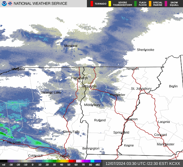
This little impulse has scaled up slowly in recent days. The MRV area is really lighting up right now, perhaps a little consolation after missing out on last night’s bonanza north of I-89
-
Upslope starting to blossom over the spine again. What a stretch!
-
Yep Margavage. His “white thanksgiving” model was laughable. Ripped the accuweather product verbatim and modified the colorbar labels.
-
Highly recommend just ignoring the CFS when forecasting storms. In addition to its resolution issues with synoptic events, there is one notorious “met” who uses it frequently on Twitter. Betting against his constant “cold and snow” calls would be more profitable than betting against Jim Cramer’s stock picks
-
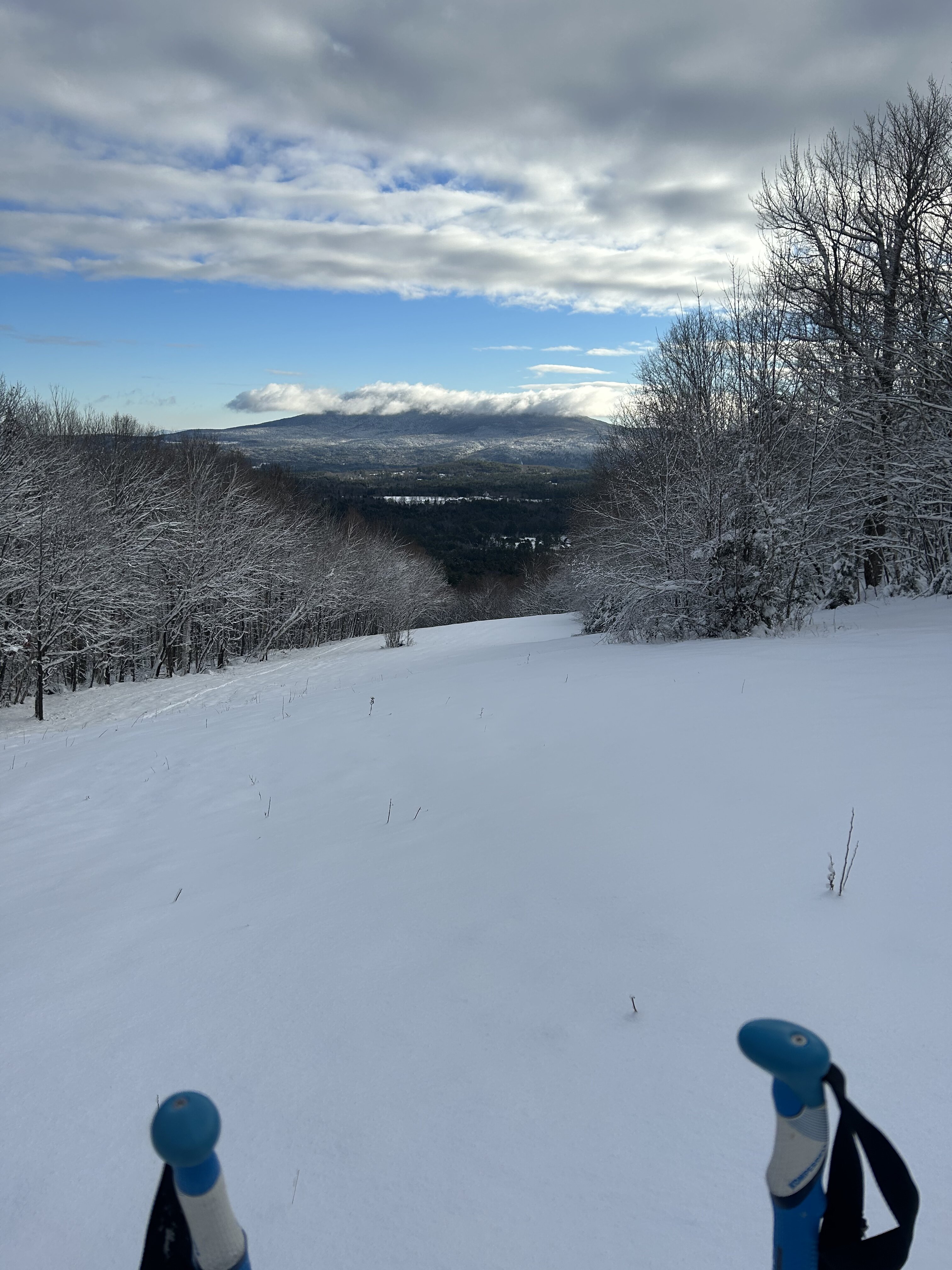
With this incoming storm likely to drop 8-12" (and potentially more), it looks like woods skiing will be game on for northern VT on the first weekend of December. Very quietly the NNE mountain snowpack has gotten off to a great early start (what happened mid-december last year was criminal). Jay looks ready to drop ropes on everything, insane stuff up there. I keep thinking back to the sleeper powder day along the spine in late November last year, keep an eye out on this Friday.
-
Looks like a Champlain enhanced snowband has been hitting the App gap and Camels Hump area pretty hard this evening. Sneaky little disturbance tonight ahead of the main clipper has been enhancing upslope production. These unstable upper level arctic troughs sometimes don't deliver down south, but the mountains will always find ways to cash in.
-
Game on in Central NH if you’re willing to work for it
-

Turkey Day Birch Bender Snow Storm/Observation Thread 11/28/-11/29
Boston Bulldog replied to dryslot's topic in New England
The ML reacharound seems to be going poof over SVT. While dynamics are waning overhead, I suspect some of this is due to distance from the radar beam. I think we have a bit more juice before things end. Eyeballing 7-8” in Sunapee, power flickering constantly over the past few hours. Impressive November event at 1100’ -
Turkey Day Birch Bender Snow Storm/Observation Thread 11/28/-11/29
Boston Bulldog replied to dryslot's topic in New England
Yep, big slug of moisture gearing up near Albany. Probably another 2-4” if that holds together -
Turkey Day Birch Bender Snow Storm/Observation Thread 11/28/-11/29
Boston Bulldog replied to dryslot's topic in New England
Yep, expecting it to take on a SW to NE alignment as H7 low matures. Anywhere SE of where it sets up may have some subsidence issues and a more showery radar. The swath of posters we have from Sullivan through Merrimack counties are going to have a close shave -
Turkey Day Birch Bender Snow Storm/Observation Thread 11/28/-11/29
Boston Bulldog replied to dryslot's topic in New England
700mb fronto band starting to take shape. Looking at radar now, it might be curling a bit SW through Vermont back towards the capital region.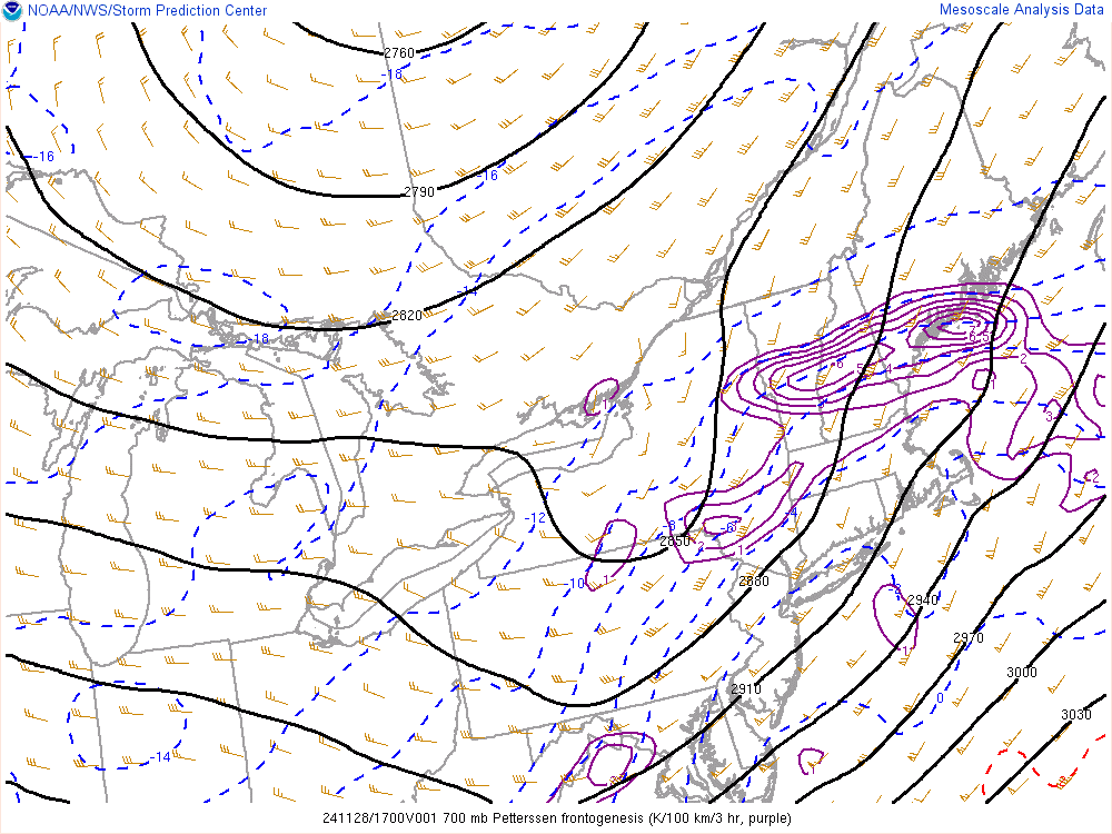
-
Turkey Day Birch Bender Snow Storm/Observation Thread 11/28/-11/29
Boston Bulldog replied to dryslot's topic in New England
Similar conditions to your west, radar looks great with additional banding pivoting in from the south. Probably around 3” here -
Turkey Day Birch Bender Snow Storm/Observation Thread 11/28/-11/29
Boston Bulldog replied to dryslot's topic in New England
Yep, 32.0 here and seems to be accumulating relatively unimpeded. Closely watching that band lifting north from Keene -
Turkey Day Birch Bender Snow Storm/Observation Thread 11/28/-11/29
Boston Bulldog replied to dryslot's topic in New England
3k NAM has some convective issues with the slp shunting a bit south. Tossed -
Turkey Day Birch Bender Snow Storm/Observation Thread 11/28/-11/29
Boston Bulldog replied to dryslot's topic in New England
Fake cold indeed. 36.7 farther north in Sunapee -
Turkey Day Birch Bender Snow Storm/Observation Thread 11/28/-11/29
Boston Bulldog replied to dryslot's topic in New England
Will be spending the duration of this storm at 1100’ near Sunapee NH, we could rip pretty good here. -
December 2024 - Best look to an early December pattern in many a year!
Boston Bulldog replied to FXWX's topic in New England
Loving the contrast between “let’s focus on the next two weeks” and “this pattern might remain through next winter” on back to back posts. -
Rafael is rapidly unraveling. The only November major hurricane in the Gulf (besides Kate). One for the record books
-
Impressive performance by Rafael this evening. Major at 10pm EST I bet. This must be the most menacing looking storm in terms of location to not even have a single TS watch or warning issued. No intermediate advisories either!
-
Blowvember - and not named for wind potential
Boston Bulldog replied to Go Kart Mozart's topic in New England
I am interested to know why this may be a mirage, tropical forcings perhaps? At first glance the high-latitude dynamics seem like they would be sufficient to temporarily tighten up the lambda on the continental rossby waveguide -
Blowvember - and not named for wind potential
Boston Bulldog replied to Go Kart Mozart's topic in New England
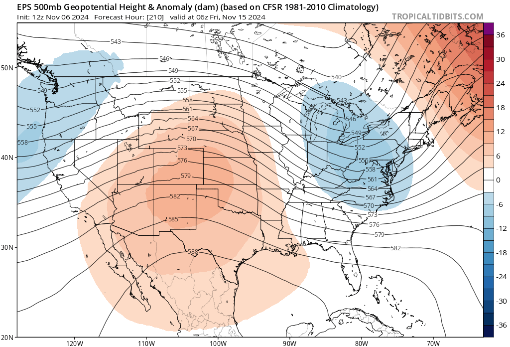
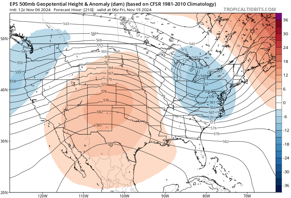
A bit of a trend emerging over the last day for mid-month on the GEFS. The EPS has shown this trough anomaly on the eastern half of the country for a little while as well. Refreshing to see long range changes, if still very far out. This potential break in the ridge will likely transient in nature as this feature propogates quickly across the CONUS.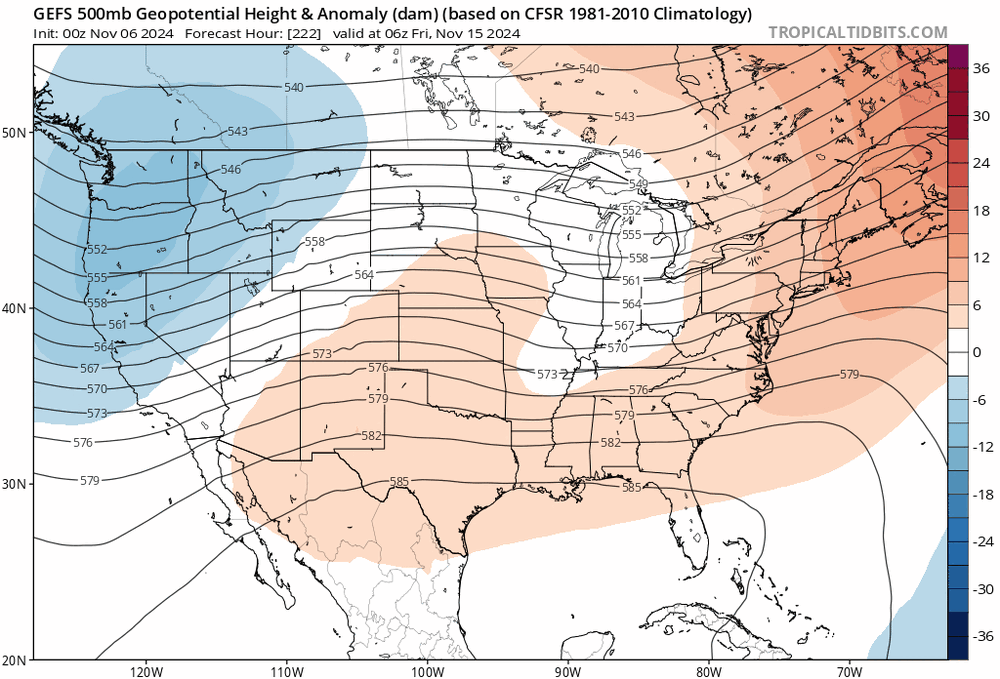
-
Blowvember - and not named for wind potential
Boston Bulldog replied to Go Kart Mozart's topic in New England
Seen this hurricane season take a few times, the NOAA forecast has verified across named storms, total hurricanes and major hurricanes. -
Extremely unlikely makes landfall in Texas. The only scenario where this storm gets close to Texas is if the storm gets ripped to shreds by shear and the LLC decouples. Cold water on approach to land is also in place. Breathe in, breathe out Hurricane Ida (2009) repeat without the secondary peak intensity IMO
-
Blowvember - and not named for wind potential
Boston Bulldog replied to Go Kart Mozart's topic in New England
The hemispheric rossby wave evolution to maintain this pattern is quite remarkable. Happy to get this out of the way in November, myself and many others would be quite angsty if this weirdly persistent pattern showed up in January. The consistent deposit of vorticity back into the western trough really drives the persistence of our downstream ridge. Very impressive how the wave structure strikes the perfect balance between trough attenuation on the low-end of vort advection, and wave breaking for high-end advection. Instead we get stasis. An impressive traffic jam of blocking downstream also slows propagation just in time for vorticity to go reinforce the pattern along the wave axes. Long story short, this ridge doesn’t want to go easy. Again, hoping for a trigger from the W-Pac to reshuffle the deck. -
Blowvember - and not named for wind potential
Boston Bulldog replied to Go Kart Mozart's topic in New England
Exactly, we are pretty locked into eastern ridging for the foreseeable future. Sure, we can get a few cool shots in from various sources here or there, but we need wholesale teleconnection changes for real progress away from the hostile rossby wave configuration we have. Subseasonal indicators are pretty iron-clad right now across the upper latitudes, and tropical forcings are not helping. A nicely timed recurving typhoon could be the trigger for changes sooner than modeled. Until that happens, or other forcings flip key indices, semi-consistent bursts of winter will be confined to the ADK High Peaks region, the Green Mountain spine, the Whites through Pittsburg, and the Mahoosucs/Aroostock county