Boston Bulldog
-
Posts
619 -
Joined
-
Last visited
Content Type
Profiles
Blogs
Forums
American Weather
Media Demo
Store
Gallery
Everything posted by Boston Bulldog
-
While the upslope has seemingly been baked in for a few days now, synoptics have been ticking a bit better for NNE folks in recent runs. The mid level coastal transfer remains a bit of a mess but has trended towards a more coherent and dynamic CMC like solution. I do expect Canadian guidance to back off a bit though.
-
Pasty synoptic snow followed by persistent upslope would be a fantastic way to rebound from this thaw
-
Good sign that random bombs are showing up on guidance. A signal should coalesce as we get closer
-
Despite the coastal system passing well south, I noticed that as the models began to depict an offshore stronger system, there was a bit of an “upslopey” look that developed. It’s likely the deeper intensity of the coastal storm meant that the NW flow got moistened by Atlantic moisture wrapping in from Atlantic Canada. If there’s cold air in place and a strong low over Atlantic Canada, it’s gonna snow along the northern spine of the greens
-
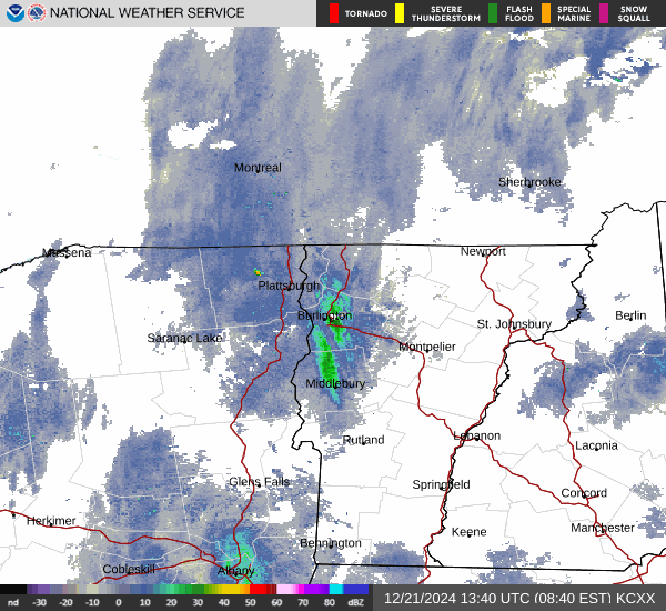
BTV did end up issuing WWAs for the Champlain valley south of Burlington, likely a fluffy 5-6 in the areas most favored by the banding.
-
The Champlain lake effect machine has been turned on!
-

12/20-21 Clipper/Coastal Nowcast and Obs
Boston Bulldog replied to Boston Bulldog's topic in New England
Would assume Blue Hill Observatory was the jackpot -
12/20-21 Clipper/Coastal Nowcast and Obs
Boston Bulldog replied to Boston Bulldog's topic in New England
Was on the wrong side of the CF in Canton for a while today, but have made up for it in this band. Dumping -
12/20-21 Clipper/Coastal Nowcast and Obs
Boston Bulldog replied to Boston Bulldog's topic in New England
Just drove across CF near route 138/Blue Hill. White rain east, 1+” west and side roads slushy/covered -
12/20-21 Clipper/Coastal Nowcast and Obs
Boston Bulldog replied to Boston Bulldog's topic in New England
35 and ocean effect rain -
12/20-21 Clipper/Coastal Nowcast and Obs
Boston Bulldog replied to Boston Bulldog's topic in New England
Just to the north of me sadly. Only occasional flakes right now. BHO likely getting pasted -
Kicked off an obs thread… hoping there are enough flakes around this evening to justify! NOTE: This was done independent of the zonked NAM run
-
Across snow starved SE New England, this system has played with the heart strings of disillusioned snow enthusiasts. An incredible longwave setup with a less than ideal shortwave configuration. Late night celebrations at big NW ticks, deep late morning depression at 12z regressions. Frequent NAMings (another one might be underway right now). The SREFs have made an appearance (forgot those existed). The “coastal” low has even been depicted as far east as the Flemish Cap in recent days… and yet here we are with some hope for a Christmas surprise. The tracking has been brutal, and the potential payout for many is likely to be questionable to say the least. Despite all this, many are still in the game for 1-3” according to BOX, with some model depictions illustrating higher potential for eastern zones. Hoping to spark some good juju and break out the nowcast from the angsty cesspool the discussion thread has been over the past week. At the minimum it will likely be festive for some in the days leading up to Christmas, a vast improvement from recent years! Also congrats Hazey
-
Festive OES flakes and 33 south of Ponkapoag in Canton. @HimoorWx and I generally benefit off of improved elevation in these marginal setups, hoping that is the case again
-
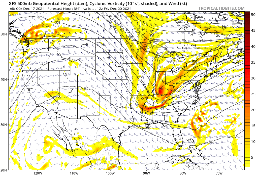
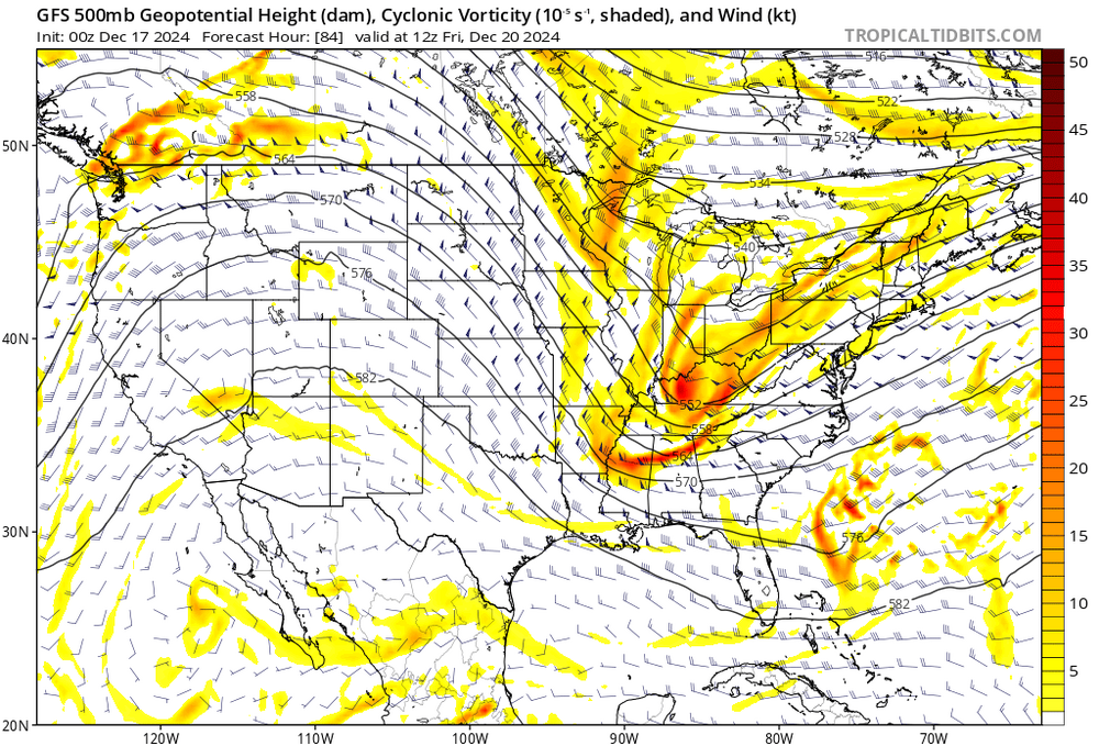
Every tick counts in the upper levels. The more you can buckle the flow downstream of the trough axis, the more the baroclinic leaf can develop to the NW. While the actual SLP doesn't trend a ton from 18z to 0z, the precip shield is definitely more expansive
-
Angel on one shoulder telling me it's just the NAM, don't look too deep into it. Devil (weenie?) on the other shoulder telling me to go all in on this trend because we have better sampling now....
-
Negative trough at 84 hours. That’s a substantial change
-
Looks like the trough on 6z GFS actually trended a bit better than 0z, but the SLP development and evolution is significantly more realistic than at 0z. No spurious convective mass modifying the surface evolution
-
I wish that is the case! Idk, this configuration just doesn't scream cyclogenesis close to NC. We need a sharper and deeper trough. And we need that to trend quickly. Decent move from 18z I guess
-
I have a few caution flags on the improved 0z GFS run. Watch where the SLP develops - it congeals on some spurious convection that forms off of FL, helping shunt the ocean storm a bit NW Sure the upper level changes are there, but I don't think they support such a substantial shift without the convective feedback
-
Slight tick better at upper levels. We should know by 12z tomorrow if this is the start of a trend back or just noise. Probably the latter?
-
Yeah sure GFS blew at 0z. You never see a coastal bomb show up every single run for days on end. Synoptic errors are so huge at this juncture, but at least there is persistence surrounding a *threat*. The signal continues to grow stronger. Even 0z keeps all the necessary pieces on the playing field, that’s all I need right now
-
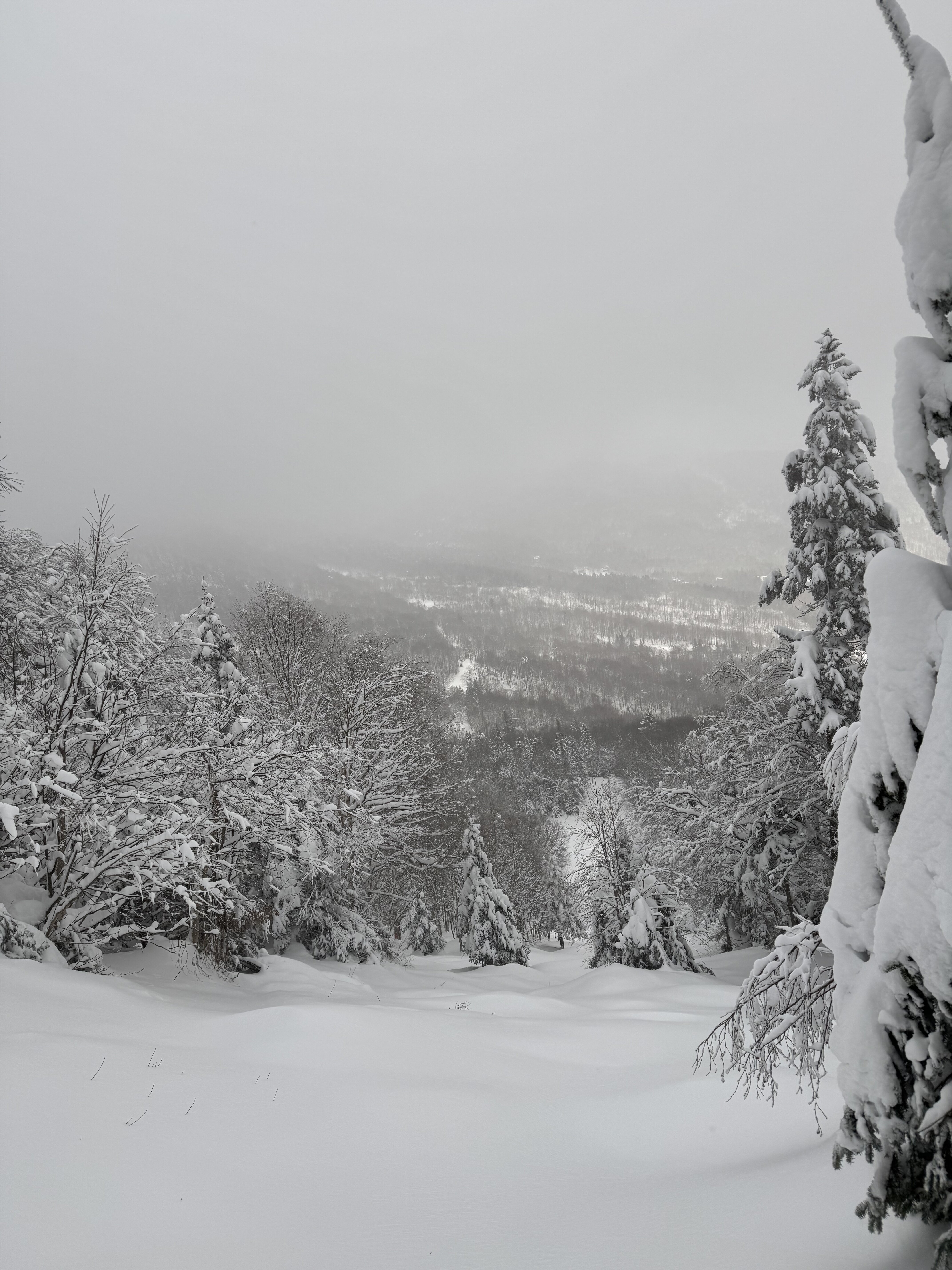
Classic upslope blower pow! Really impressive stuff out of Mount Mansfield. It wasn’t nearly as deep farther south at MRG, but still some great (albeit thin cover) powder in the upper elevations. Frozen mud on the pole tips means low tide! Not sure if the natural snow at Sugarbush would’ve held up on most trails for a busy weekend crowd.

-
December 2024 - Best look to an early December pattern in many a year!
Boston Bulldog replied to FXWX's topic in New England
Absolutely firing at MRG right now. 6+ easily up high overnight and still dumping.