aggiegeog
-
Posts
1,235 -
Joined
-
Last visited
Content Type
Profiles
Blogs
Forums
American Weather
Media Demo
Store
Gallery
Everything posted by aggiegeog
-
Hi-Res models (MRRR and RAP) have the precip shield further north which gives DFW 3-6" with 6"+ to the west, south and east. Regional models (NAM and RGEM) are a touch south of the Hi-Res giving DFW 1-3". I-20 may well be shut down Monday from Monroe to Midland with 4-8" along that whole stretch.
-
Looks like QPF is similar on most models determining factor especially for us in E TX will be if it is 33 vs 35 Sunday afternoon. If we end up with the talked about but impossible to forecast convective band cooling then all bets are off and totals will pile up fast. Mid 30s would yield around a 6:1 ratio while low 30s would likely be closer to 8:1. In isolated convective bands we could talk about over 10:1.
-
Ok let's call it cold air then. True Arctic air would not support snow. I think its more likely we see temps dropping into the 20s under the heavy bands given the cold temps at 850 and even at 925. Daytime temps for North Central TX outside of the heavy bands will likely be 33 to 35 so there may be some melting. Under the heavy bands we are looking at >2"/hr rates with temps at or below freezing and ground temps not crazy warm given time of year and current cool temps. I am very confident in storm max totals being in the range of a foot or perhaps greater with widespread 6".
-
RGEM seems to be handling the convective nature of this event well even if the QPF may be overdone. Though around 1" QPF for a dynamic system with great moisture is clearly possible. I believe and there will be a number of areas that receive near or over 12" with the area between Hillsboro and Nacodoches being the most likely stretch to see that. All models give this area between 0.5 and 1.5" QPF with temps supporting primarily snow. Texas has been waiting 11 years for a Gulf surface low, potent upper low combo pumping moisture into an Arctic air mass.
-
I could see that, I haven't focused hard on that area since my audience is generally DFW and E TX. I do think the area between Lubbock/Big Spring and east could see some good totals (likely will up that area to the 7" type range). My biggest question for now is the Amarillo to Wichita Falls area, do they stay in the 1-2" range. Deep East Texas is another tricky forecast as they will have 1-2" QPF but when will the change to all snow occur, the Lufkin to Jasper area could see anywhere from just a mix to 10" of snow.
-
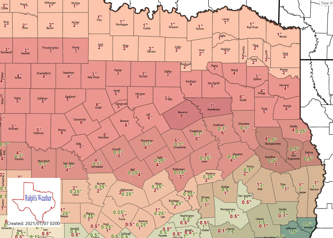
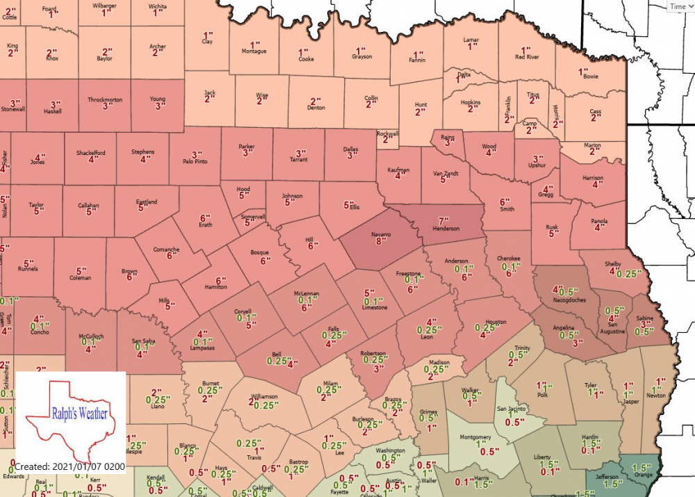
Good point and something to watch out for in DFW. I am not overly bullish on DFW and north. I am thinking Waxahachie, Corsicana, Athens, Tyler and Nacogdoches will be the sweet spot with amount tapering off quickly north of I-20 and areas to the south dealing with rain for some time. Below is the map I put together last night. I think it is still in decent shape though amounts may taper off even more sharply along and north of I-30.
-
06Z and 12Z GFS are just an example of the GFS's warm bias, they are 5-10 degrees warmer at the surface than other models otherwise the GFS is the same as the other models. We know we will have a strong upper low crossing the state Sunday with a cold air mass already in place. This upper low will generate a coastal low which will throw a lot of moisture into the path of the cold upper low. I am expecting a 150 mile wide swath of heavy snow across Texas generally along and south of I-20 though that swath could shift 50 miles north or 100 miles south. If you are in the core of the heavy swath though I don't see you missing out totally at this point. We are talking about a potential historic snow event for north Central and East Texas with 0.5-1.5" QPF in areas where the temperature profile suggests primarily a snow precip type.
-
Wow, looks like we could see a 1982 or even 2010 type event out of this. Models showing maxes around a foot south of I-20 and 3-6" along I-20 with around an inch along the Red River. There will likely be some impressive thundersnow which will drop snow at rates in excess of 2" per hour so even with above freezing surface temps accumulations could be hefty even on roads.
-
I do think the best snow will be south of DFW, say Waxahachie to Palestine to Marshall. Thankfully this will be basically all snow for N and E TX. If 1" plus QPF verifies in these areas it will be wild, but even 0.5" QPF would make this one of the top snow events for these areas.
-
Looks like the I-20 corridor of TX will see a classic snow storm Saturday through Monday.
-
MO/KS/AR/OK 2020-2021 "Winter" Discussion
aggiegeog replied to JoMo's topic in Central/Western States
There are multiple reports of over a foot of snow in West and Southwest Texas from this storm. Thundersnow also reported west of Fort Worth with heavy snow. I expect Oklahoma will do well overnight. The surface low is in SE OK now. -
Hearing that there is some sleet mixed in with your batch further west.
-
Someone in a Waco to DFW to Texarkana triangle is in line for a big time snow event with strong winds on NYE.
-
Snow chances are increasing for the northern half of Texas after mid week.
-
Saw that Angel Fire dipped to -21 Wednesday morning. Man it gets cold there on ideal radiational cooling nights.
-
Red River counties of N and NE TX could see a dusting of snow later today. Heavy snow in OK. Upper 30s to low 40s and wet for N and NE TX today.
-
Nacogdoches made it down to 19 this morning, Tyler made it to 27.
-
The only significant weather happening over the next week in our region is a decent mountain snow for northern and western NM this weekend into early next week.
-
38 yesterday and 36 today in Lindale.
-
I am loving what I am seeing for NM and TX for late fall/early winter. Cold shots with good moisture. I expect mid winter to be cold and dry. Who knows about late winter/early spring but my bet is warm for that period.
-
Already hearing some totals nearing 2 feet across northern NM. Wondering if there will be any 3 feet totals from this event, I expect there will be.
-
GFS keeps teasing a northern TX winter event next week. I am not buying it outside of the Panhandle at this point though. Arctic dry air usually cuts off precip faster in reality than models depict.
-
The main excitement for this winter will be how low can we get the temps. Its a great set up for a few short lived but severe cold shots. Can we get into the single digits with sub 0 for western N TX? It will likely be dry though. Hopefully we can get a couple NW flow high ratio surprises though. Beautiful weather after today though. Maybe some showers with each front then highs in the 60s with lows in the 40s post fronts. i do like seeing the rapid succession of the fronts, if that continues into winter maybe we wont see the big warmups between fronts. This is a winter where we could see some 90s in Feb though.
-
This morning was the coolest of the fall so far. Reached the mid 40s.
-
It is amazing how the NAM handles these so much better than anything else. The CMC sometimes gets it right but that may just be that it is cold biased overall around here. I think the best blend is use a Euro/GFS blend for upper air and once within 3 days follow the NAM for surface temps.