snowdude
-
Posts
776 -
Joined
-
Last visited
Content Type
Profiles
Blogs
Forums
American Weather
Media Demo
Store
Gallery
Everything posted by snowdude
-
Southern MD / Lower Eastern Shore weather discussion
snowdude replied to PrinceFrederickWx's topic in Mid Atlantic
The latest SREF holds serve and keeps Salisbury's mean snow at about 4 inches so that's borderline warning criteria. -
Southern MD / Lower Eastern Shore weather discussion
snowdude replied to PrinceFrederickWx's topic in Mid Atlantic
But these forecasters in Wakefield are meteorologists and we are now less than 24 hours away and they've made no decisions on winter highlights for the region while there is a warning for the counties north. Wakefield is consistently slow and late with everything. Their totals aren't even close to matching Mount Holly's border counties. They are nervous and not confident but make a decision. You're a meteorologist! Make a decision anyway. I mean, not even a winter storm watch? Is that going to hurt your verification Wakefield if a watch is issued? Sorry I am frustrated. This is 2 years of working in the Wakefield aread and seeing no changes or improvements with their forecasts. -
Southern MD / Lower Eastern Shore weather discussion
snowdude replied to PrinceFrederickWx's topic in Mid Atlantic
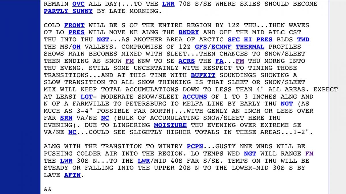
Wakefield not bullish as always. 1-3 for ALL AREAS.
-
Southern MD / Lower Eastern Shore weather discussion
snowdude replied to PrinceFrederickWx's topic in Mid Atlantic
NWS Wakefield says they held off on issuing watches because the models warmed the Thursday system. Huh? I'm not seeing that. Anyone else? -
Southern MD / Lower Eastern Shore weather discussion
snowdude replied to PrinceFrederickWx's topic in Mid Atlantic
Right now I think the chances for at least 2 inches of snow and sleet for areas north of a line from Richmond to Wallops Island is about 60% with at least 4 inches at 30%. Chances are improving. -
Southern MD / Lower Eastern Shore weather discussion
snowdude replied to PrinceFrederickWx's topic in Mid Atlantic
Same here. -
Southern MD / Lower Eastern Shore weather discussion
snowdude replied to PrinceFrederickWx's topic in Mid Atlantic
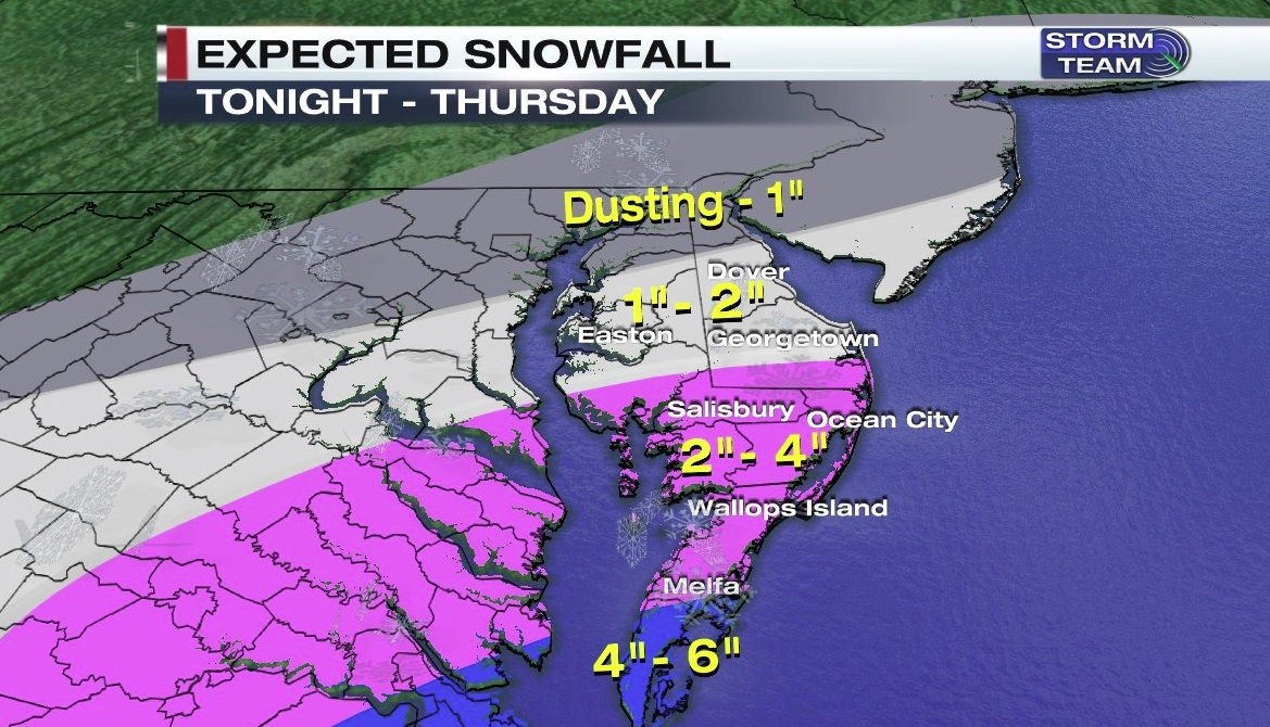
This system is quite interesting and kind of rare. It's essentially a cold front. It will all depend on the timing of the cold air. If it can get through here in time we could see a significant snowstorm. I like the GFS lately with predicting snows and it gives most of us at least 4 inches, not the 12z GFS, I think that's too snowy. I think the NAM is too far north and so is the GGEM. We will see how things pan out on the 00z runs. Hopefully nothing trends toward the NAM. -
Southern MD / Lower Eastern Shore weather discussion
snowdude replied to PrinceFrederickWx's topic in Mid Atlantic
Thanks for the observation! Oh and shameless plug here for everyone on the board. But if you have facebook or twitter be sure to like me and follow me Facebook: Meteorologist Daniel Johnson Twitter: DanielJohnsonwx -
Southern MD / Lower Eastern Shore weather discussion
snowdude replied to PrinceFrederickWx's topic in Mid Atlantic
A total of 5 inches in Salisbury! Decent storm and it feels good when you get the forecast right -
Southern MD / Lower Eastern Shore weather discussion
snowdude replied to PrinceFrederickWx's topic in Mid Atlantic
3.5 inches in Salisbury and still snowing at a moderate clip! -
Southern MD / Lower Eastern Shore weather discussion
snowdude replied to PrinceFrederickWx's topic in Mid Atlantic
This is a very juicy system. Actually it may be more juicy than last weeks storm. I think ratios will be 10:1 and 12:1 with bigger flakes, more moisture, and not as dry as last storm when we saw such small flakes and fine snow that took forever to build up. My gut is saying 4"-7" in Salisbury, 2"-4/3"-5 just north and west of there. I wouldn't be surprised if there are some 8"+ amounts somewhere from Salisbury south. Get ready everyone! -
Southern MD / Lower Eastern Shore weather discussion
snowdude replied to PrinceFrederickWx's topic in Mid Atlantic
Yeah the EURO finally got a clue and the Canadian all look much better. -
Southern MD / Lower Eastern Shore weather discussion
snowdude replied to PrinceFrederickWx's topic in Mid Atlantic
I upped my totals. I'm thinking 3"-4" St. Mary's, Calvert....5"-6" Salisbury....4"-7" Ocean City and south. I'm scared. HAHA -
Southern MD / Lower Eastern Shore weather discussion
snowdude replied to PrinceFrederickWx's topic in Mid Atlantic
The snow graphic, point and click, and actual advisory almost NEVER agree and that makes ZERO sense. I'm not sure what the NWS thinks I am getting.... 1"-3", 2"-5", or 2"-3" in Salisbury? All three are different. LOL. -
Southern MD / Lower Eastern Shore weather discussion
snowdude replied to PrinceFrederickWx's topic in Mid Atlantic
A good dusting here in Salisbury but just south I think close to an inch. Schools are closed. LOL -
Southern MD / Lower Eastern Shore weather discussion
snowdude replied to PrinceFrederickWx's topic in Mid Atlantic
Here's what I am thinking. I may bump these up though!
-
Southern MD / Lower Eastern Shore weather discussion
snowdude replied to PrinceFrederickWx's topic in Mid Atlantic
You're absolutely right it'll be a huge bust, but I am a bit nervous because the GFS has been doing better this year especially with potential snowstorms in the short range and I don't like that it doesn't show much. Something is going to bust badly! -
Southern MD / Lower Eastern Shore weather discussion
snowdude replied to PrinceFrederickWx's topic in Mid Atlantic
NAM still brings accumulating snow onto peninsula. Not as much as 06z but a general 2"-5" RGEM is pretty. lol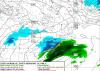
-
Southern MD / Lower Eastern Shore weather discussion
snowdude replied to PrinceFrederickWx's topic in Mid Atlantic
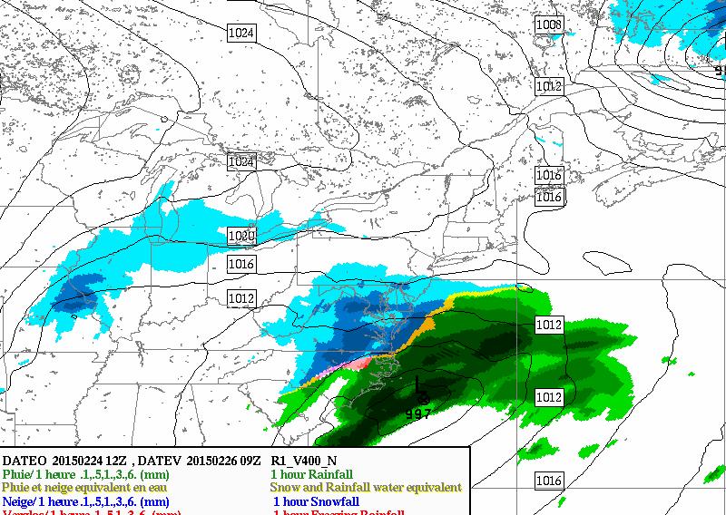
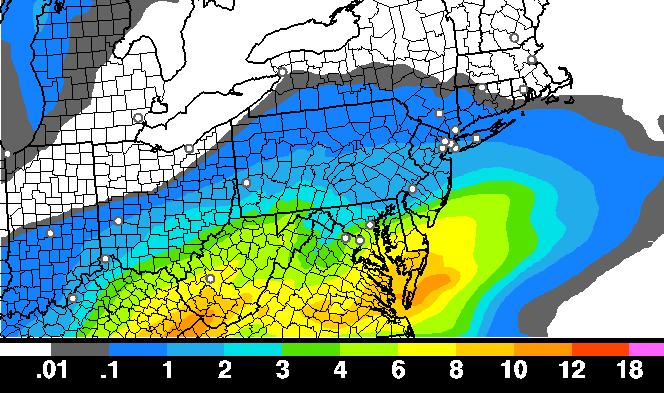
Dare I say 9z SREF is even snowier! Wow, it continues to show numerous snowy solutions. The mean snow for Salisbury is now up to 8" but that's due to some ridiculously high solutions, so it's more like 6" or so. If the SREF is right it would be a BIG win for them or a HUGE bust if wrong because global models continue to show less snow. We'll see what the 12z suite says. -
Southern MD / Lower Eastern Shore weather discussion
snowdude replied to PrinceFrederickWx's topic in Mid Atlantic
You're welcome! It's good to see an eastern shore and lower southern Maryland thread. haha. I try to get on as often as I can. Haven't been as active as I can be. -
Southern MD / Lower Eastern Shore weather discussion
snowdude replied to PrinceFrederickWx's topic in Mid Atlantic
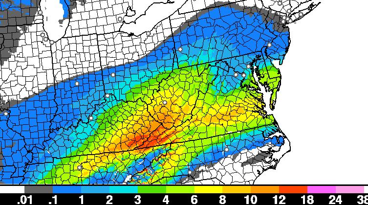
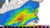
This is hard to believe when most globals showing nothing close to this, but we've seen trends like this before. Here's 6z NAM 4k: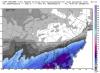
-
Southern MD / Lower Eastern Shore weather discussion
snowdude replied to PrinceFrederickWx's topic in Mid Atlantic
Yeah it's tough to say much about it when almost all of the global models say "I don't think so." I'm mentioning it this morning though on 47ABC -
Southern MD / Lower Eastern Shore weather discussion
snowdude replied to PrinceFrederickWx's topic in Mid Atlantic
12z GFS ensembles brings 0.10-0.25 across Delmarva for Thursday 12z GGEM and EURO trends a bit more north 12z UKMET gives Salisbury 1"-2" And SREF continues to trend wetter. Latest guidance (15z SREF) has Salisbury at a mean of 3.0" of snow! And that's after taking out the top three snowiest and lowest 3 snowiest solutions .Hmmm...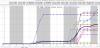
-
Southern MD / Lower Eastern Shore weather discussion
snowdude replied to PrinceFrederickWx's topic in Mid Atlantic
Latest RAP computer model is showing 8"-10" of snow on ground in Salisbury by 7am tomorrow! The HRRR says there will be 4"-6" on the ground by 3am!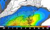
-
Southern MD / Lower Eastern Shore weather discussion
snowdude replied to PrinceFrederickWx's topic in Mid Atlantic
Conditions sure look ripe for a lower Maryland eastern shore snowstorm. Hoping this afternoons models remain the same as last nights.