snowdude
-
Posts
776 -
Joined
-
Last visited
Content Type
Profiles
Blogs
Forums
American Weather
Media Demo
Store
Gallery
Everything posted by snowdude
-
Southern MD / Lower Eastern Shore weather discussion
snowdude replied to PrinceFrederickWx's topic in Mid Atlantic
Latest hires NAM 18z...trending snowier. Shows as much snow as euro does for Salisbury. The question is, will this trend continue? Is it real? And how much of a role will borderline temps and a warmer ground play?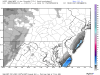
-
Southern MD / Lower Eastern Shore weather discussion
snowdude replied to PrinceFrederickWx's topic in Mid Atlantic
I posted this to my Facebook earlier in regard to the Thursday night possible snow. Give me some LIKES https://m.facebook.com/story.php?story_fbid=1112770772088832&id=150205931678659¬if_t=like&ref=bookmarks -
Southern MD / Lower Eastern Shore weather discussion
snowdude replied to PrinceFrederickWx's topic in Mid Atlantic
With the AO being pretty positive during this week, the cold air will be tough to get unlike this last storm, however, there looks to be just enough cold air where there may be some accumulating snow if this system trends west, which there is a chance of. Right now I'd say about a 20-30% for the DC area, 40-50% chance along eastern shore. Stay tuned for sure... -
Southern MD / Lower Eastern Shore weather discussion
snowdude replied to PrinceFrederickWx's topic in Mid Atlantic
About 10 inches in Cambridge, MD. -
Southern MD / Lower Eastern Shore weather discussion
snowdude replied to PrinceFrederickWx's topic in Mid Atlantic
Very windy with moderate to heavy snow falling as heavy echos push through Cambridge, MD. Temp has been steadily falling from 28 down to 24. -
Southern MD / Lower Eastern Shore weather discussion
snowdude replied to PrinceFrederickWx's topic in Mid Atlantic
Impressive. Conditions have been colder today... And no, it won't put us in blizzard territory just because of snow totals. We need the wind speeds for that which I personally believe we will be in for at least some time. I mean come on we will be getting 40-60 mph gusts. Maybe it will be expanded for blowing snow? We will see. But don't hold your breath, it's Wakefield -
Southern MD / Lower Eastern Shore weather discussion
snowdude replied to PrinceFrederickWx's topic in Mid Atlantic
Roads becoming completely covered in Cambridge, MD. Moderate snow. Eye-balling probably a quarter inch or so. -
Southern MD / Lower Eastern Shore weather discussion
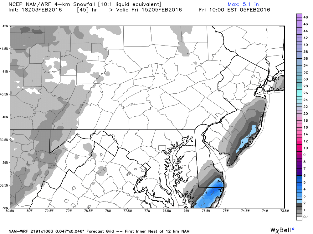
snowdude replied to PrinceFrederickWx's topic in Mid Atlantic
Amount of snow expected to be on the ground according to HRRR by 11pm with rain/snow line still south of Salisbury. Probably a few more inches before switch over.
-
Southern MD / Lower Eastern Shore weather discussion
snowdude replied to PrinceFrederickWx's topic in Mid Atlantic
Probably the RPM (tv met model). Plus GFS and NAM showed lots of mixing during 00z runs last night, but shouldn't panic on one run yet. -
Southern MD / Lower Eastern Shore weather discussion
snowdude replied to PrinceFrederickWx's topic in Mid Atlantic
Yeah it is worrisome, but hopefully it's just a blip and a wobble. But the NW trend is a real thing, it happens a lot during these storms and that's what worryies me. 12z today and 00z tonight will be big runs. -
Southern MD / Lower Eastern Shore weather discussion
snowdude replied to PrinceFrederickWx's topic in Mid Atlantic
Here's what we are thinking at 47ABC. I'd say it's pretty conservative. Lol
-
Southern MD / Lower Eastern Shore weather discussion
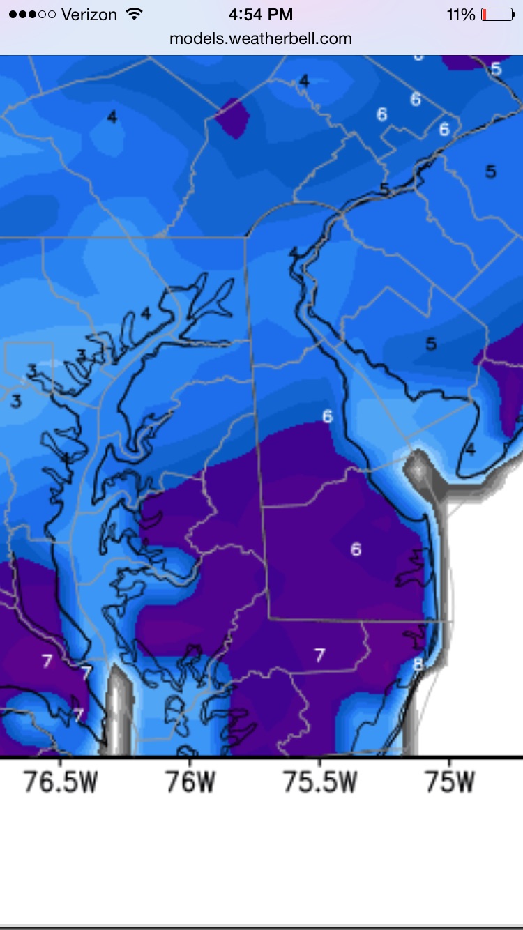
snowdude replied to PrinceFrederickWx's topic in Mid Atlantic
Right now I'm thinking the front end thump will be where we see the most snow. Probably 4"-8" in Salisbury before changing to rain and sleet. Could get another couple inches Saturday evening/night when it changes back, maybe more especially if dynamics remain strong and a possible deformation band sets up. Still have time to narrow everything down. -
Southern MD / Lower Eastern Shore weather discussion
snowdude replied to PrinceFrederickWx's topic in Mid Atlantic
Yeah, totally agreed. -
Southern MD / Lower Eastern Shore weather discussion
snowdude replied to PrinceFrederickWx's topic in Mid Atlantic
I think Easton will see quite a bit of snow. More than Salisbury and areas south of you. Yes, some mixing does look likely. -
Southern MD / Lower Eastern Shore weather discussion
snowdude replied to PrinceFrederickWx's topic in Mid Atlantic
Also, mini heat wave next week? GFS is downplaying highs and likely wrong, as ECMWF and GGEM are much warmer. NWS agrees: FAVORING ECMWF FOR HIGHS (GFS HIGHS ONLY IN MID-UPPER 80S WELL INLAND APPEARS TOO COOL IN THIS PATTERN). CONDITIONS WILL GENLY BE ABOUT 5 DEGREES COOLER AT THE COAST. -
Southern MD / Lower Eastern Shore weather discussion
snowdude replied to PrinceFrederickWx's topic in Mid Atlantic
Most likely an inactive season or at least a boring season due to developing moderate to strong El Nino, but you never know really. NHC puts out their official forecast next week. -
Southern MD / Lower Eastern Shore weather discussion
snowdude replied to PrinceFrederickWx's topic in Mid Atlantic
Looks like we all cashed in. Congrats everyone! I got between 3"-4" in Salisbury. I love when I get a forecast right It was a pretty good winter overall. Time to sit back and wait for the warmth now! Still can't guarantee winter is over though. -
Southern MD / Lower Eastern Shore weather discussion
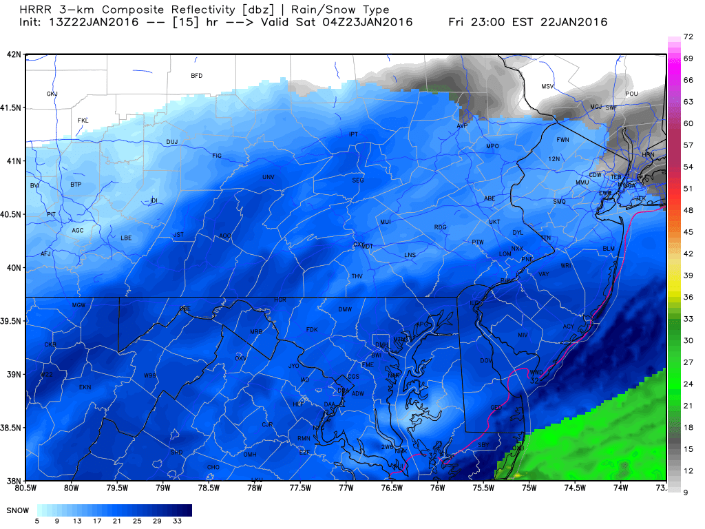
snowdude replied to PrinceFrederickWx's topic in Mid Atlantic
We have some very heavy snow bands to get through over the next several hours moving in from Virginia. -
Southern MD / Lower Eastern Shore weather discussion
snowdude replied to PrinceFrederickWx's topic in Mid Atlantic
Snow in Salisbury! Finally! Haha now hurry up and accumulate 3 inches. Lol -
Southern MD / Lower Eastern Shore weather discussion
snowdude replied to PrinceFrederickWx's topic in Mid Atlantic
We love when these pop up, don't we? haha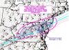
-
Southern MD / Lower Eastern Shore weather discussion
snowdude replied to PrinceFrederickWx's topic in Mid Atlantic
Sleet mixing in Salisbury -
Southern MD / Lower Eastern Shore weather discussion
snowdude replied to PrinceFrederickWx's topic in Mid Atlantic
Amazing consistency with the GFS for several runs. Hopefully it's right.
-
Southern MD / Lower Eastern Shore weather discussion
snowdude replied to PrinceFrederickWx's topic in Mid Atlantic
Oh yeah!!!!!! Just like they should have hours ago? Hours late with ANOTHER storm AGAIN! -
Southern MD / Lower Eastern Shore weather discussion
snowdude replied to PrinceFrederickWx's topic in Mid Atlantic
NWS just got NAM'd. Haha -
Southern MD / Lower Eastern Shore weather discussion
snowdude replied to PrinceFrederickWx's topic in Mid Atlantic
Wakefield said either a warning or advisory will be issued by 3pm.