snowdude
-
Posts
776 -
Joined
-
Last visited
Content Type
Profiles
Blogs
Forums
American Weather
Media Demo
Store
Gallery
Everything posted by snowdude
-
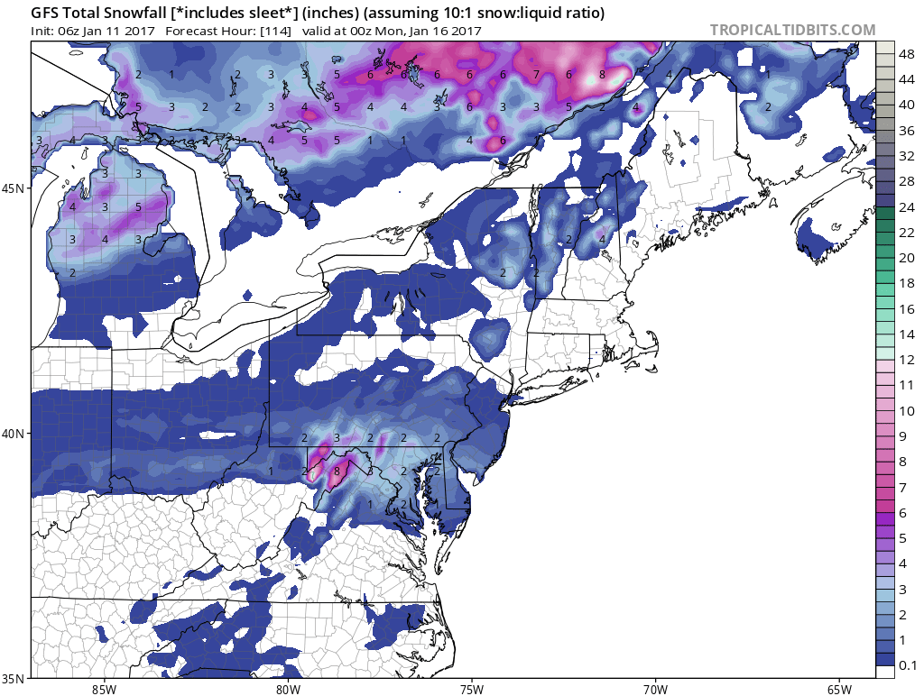
FV3 GFS did MUCH better than regular GFS.
-
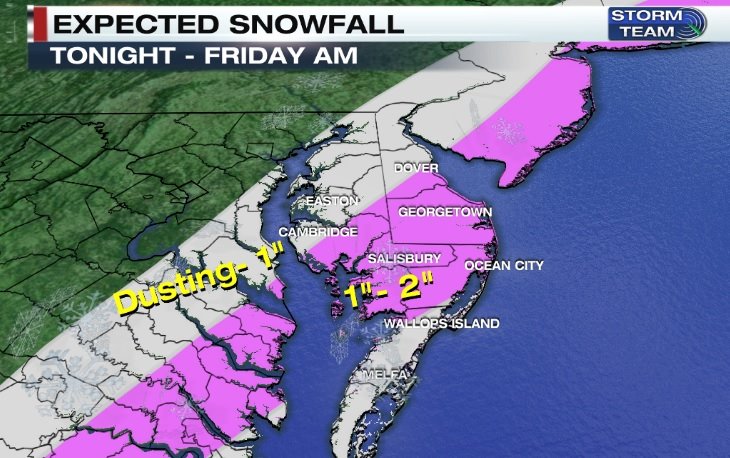
Winter Weather Advisories expanded to eastern shore of Maryland now. A nice dusting, maybe more now in Cambridge.
-
Southern MD / Lower Eastern Shore weather discussion
snowdude replied to PrinceFrederickWx's topic in Mid Atlantic
Our winter outlook at 47 ABC. -Above average snowfall -Colder than normal temps -February being coldest and most active, but even December will have early snow chances (unlike a normal El Nino) -Frequent coastal storms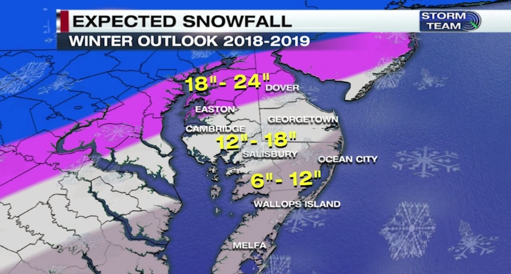
-
Southern MD / Lower Eastern Shore weather discussion
snowdude replied to PrinceFrederickWx's topic in Mid Atlantic
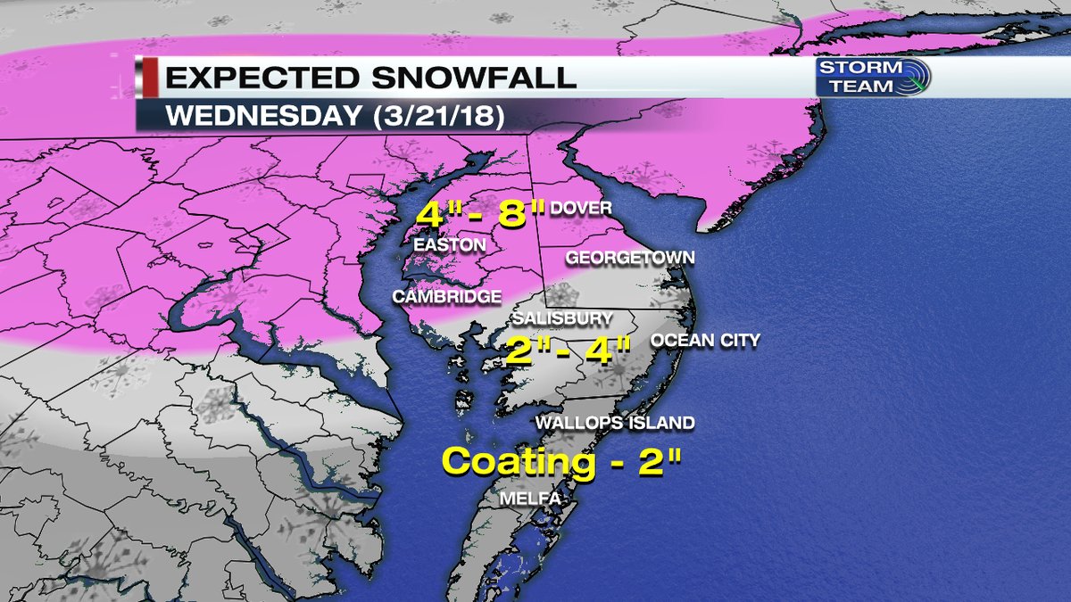
Well well well.....this morning I was ready to jump out of the gate and dramatically bump up our snow map, but then I saw the 12z guidance today and the warm nose. Ah! A very fragile setup indeed. I have SBY in 2-4" and areas just NW (Cambridge/Easton) in 4-8", so I did bump up totals a bit. I think whoever is under banding will truly win out. But a very close call for SBY south. Even southern DE may be in the warm nose for a bit. But these highly convective winter storms can overachieve and impress, even in March. Thundersnow is almost a guarantee in my opinion tomorrow in spots. So it's time to wait and see what happens!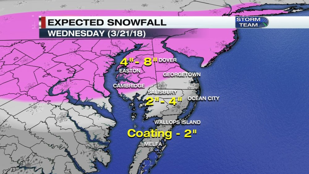
-
Southern MD / Lower Eastern Shore weather discussion
snowdude replied to PrinceFrederickWx's topic in Mid Atlantic
Our current thinking. Definitely does't help with the heaviest falling during the middle of the day. We're saying mainly sticking on grassy surfaces and there could be slick slushy roads. However, some snow looks to be heavy, and that could overcome some warm ground issues, especially north.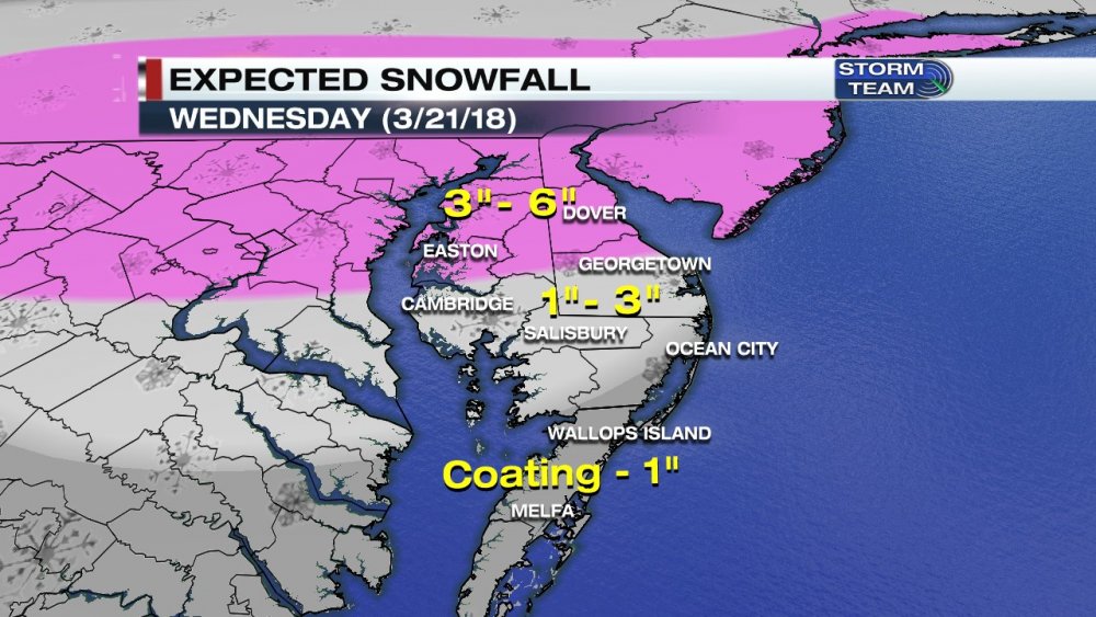
-
Southern MD / Lower Eastern Shore weather discussion
snowdude replied to PrinceFrederickWx's topic in Mid Atlantic
What a storm guys, what a storm! Measured 11.5” in Salisbury. -
Southern MD / Lower Eastern Shore weather discussion
snowdude replied to PrinceFrederickWx's topic in Mid Atlantic
With ratios in place I could see that. But I'm thinking more isolated spots could see that in heaviest banding. This is a monster storm. Could be surprised in the end (in a good way). -
Southern MD / Lower Eastern Shore weather discussion
snowdude replied to PrinceFrederickWx's topic in Mid Atlantic
I know, right? Been off this site for a while for some reason. lol. And thanks! Hey, the RAP looks great for our area. haha. -
Southern MD / Lower Eastern Shore weather discussion
snowdude replied to PrinceFrederickWx's topic in Mid Atlantic
I see you guys getting close to 6", maybe more as the low bombs off the coast. I was just a bit concerned with some dry air at first.
-
Southern MD / Lower Eastern Shore weather discussion
snowdude replied to PrinceFrederickWx's topic in Mid Atlantic
I was getting nervous watching HRRR today cause it showed dry air eating away our snow, but it's now trending in the right direction in terms of a good snowstorm. And yes, the eastern batch of moisture in Atlantic and western moisture in southwest VA will consolidate and radar fills in. I'm not too worried about dry slotting here in Salisbury. But dry air will limit some accumulation NW of town. Yes! Sorry I wasn't here for the early December storm, but we nailed that one for Saliisbury. -
Southern MD / Lower Eastern Shore weather discussion
snowdude replied to PrinceFrederickWx's topic in Mid Atlantic
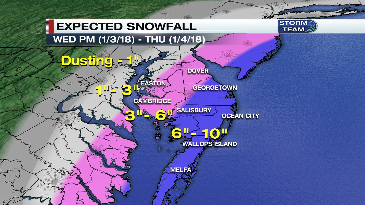
And I say 6-10" -
Southern MD / Lower Eastern Shore weather discussion
snowdude replied to PrinceFrederickWx's topic in Mid Atlantic
I don't love the RPM but here's its latest. Bullseye in Wicomico, Dorchester, Sussex counties on Delmarva. I think a general 1-2 is a safe bet for Salisbury on north. Some higher amounts possible.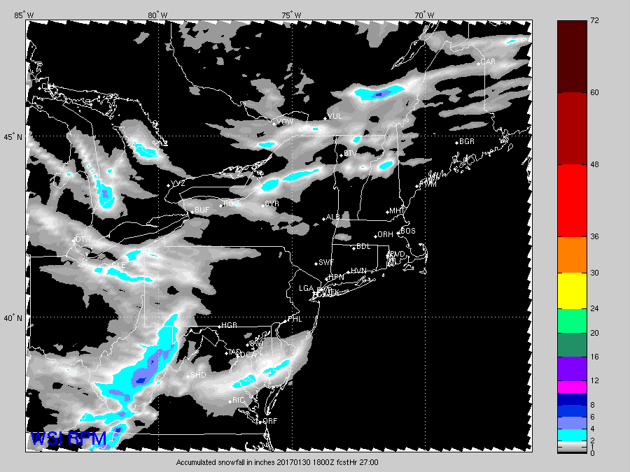
-
Southern MD / Lower Eastern Shore weather discussion
snowdude replied to PrinceFrederickWx's topic in Mid Atlantic
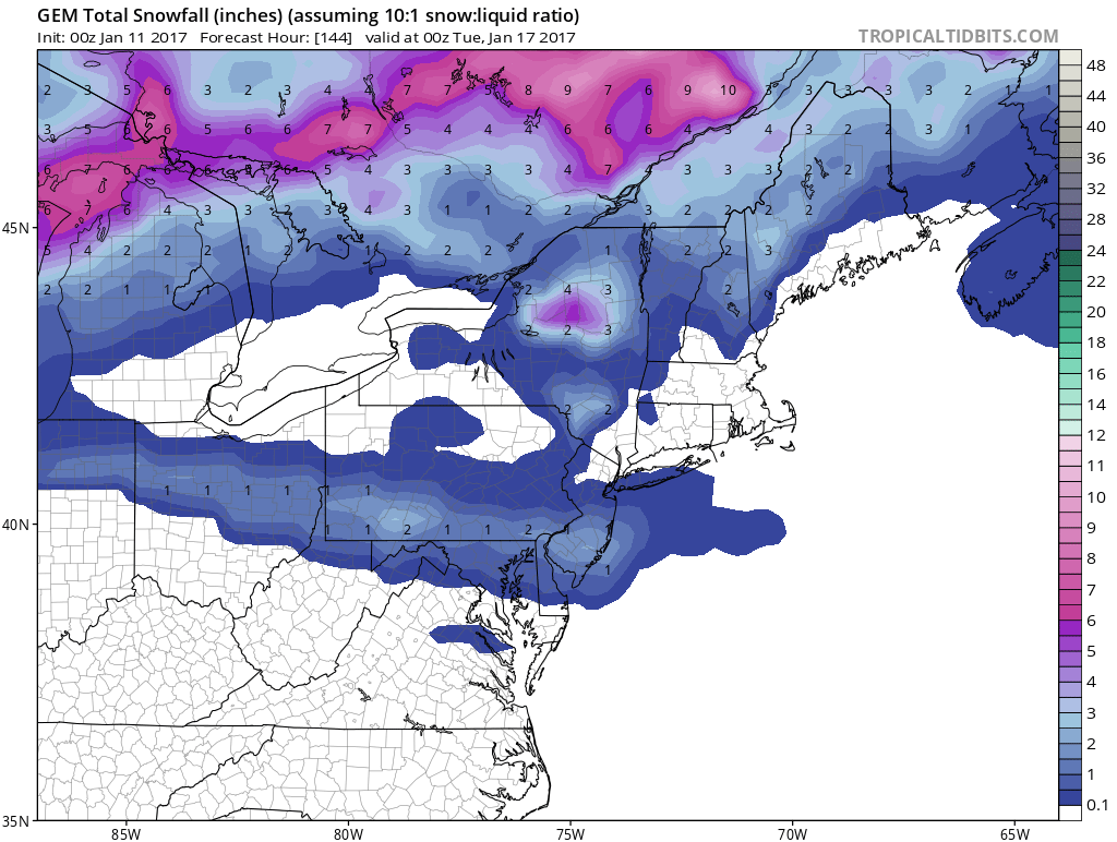
Canadian is kinda pretty...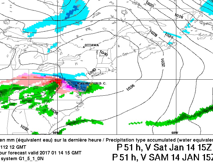
-
Southern MD / Lower Eastern Shore weather discussion
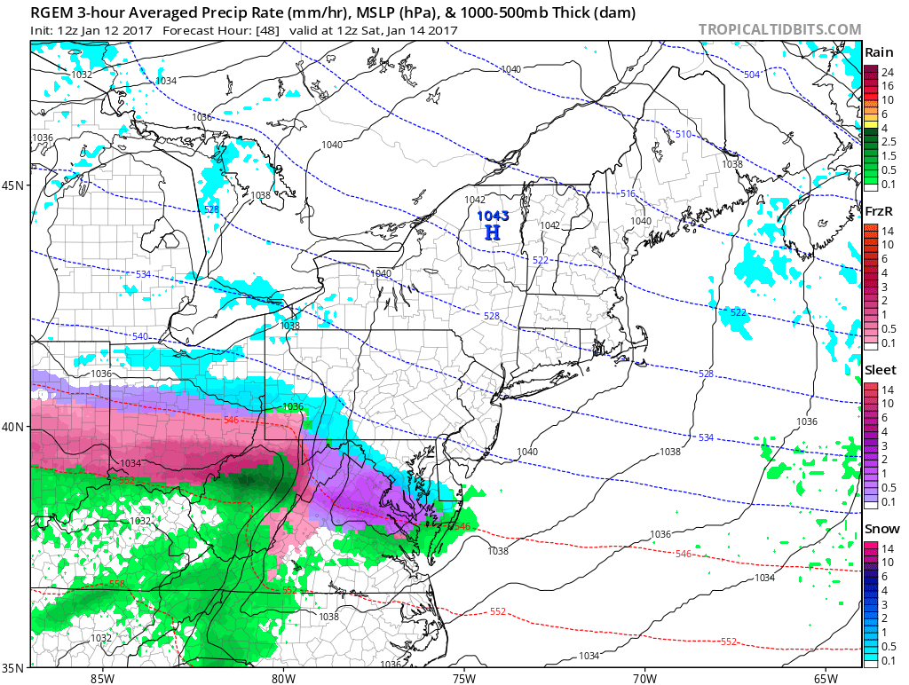
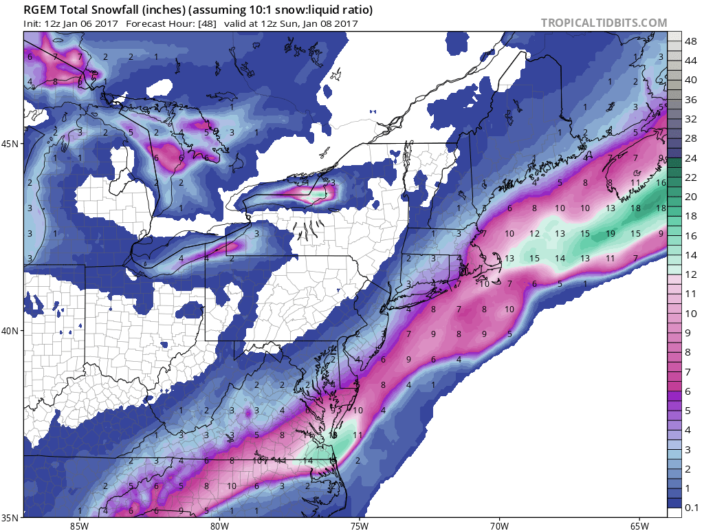
snowdude replied to PrinceFrederickWx's topic in Mid Atlantic
RGEM coming into range
-
Southern MD / Lower Eastern Shore weather discussion
snowdude replied to PrinceFrederickWx's topic in Mid Atlantic
CMC, EURO, and GFS for this weekend. Trending colder. Some of this will likely be sleet/freezing rain. Gotta watch that chance.

-
Southern MD / Lower Eastern Shore weather discussion
snowdude replied to PrinceFrederickWx's topic in Mid Atlantic
Don't let your guard down for this weekend. Possible wintry mix to watch. May be too far north though. -
Southern MD / Lower Eastern Shore weather discussion
snowdude replied to PrinceFrederickWx's topic in Mid Atlantic
I didn't totally miss out. I was in my senior year of college in Millersville, PA. We got hammered too. I'm from VA so I've been around for a lot of our storms. I'm just "new" to the shore. -
Southern MD / Lower Eastern Shore weather discussion
snowdude replied to PrinceFrederickWx's topic in Mid Atlantic
I'm just surprised. Out of the four years I've lived on the shore, all of them have had above average snowfall. That's pretty rare here. Keep the streak going! Looks like a warming tend for next couple weeks (on average), then hopefully some new cold and snow chances. -
Southern MD / Lower Eastern Shore weather discussion
snowdude replied to PrinceFrederickWx's topic in Mid Atlantic
I knew this storm would overperform. Congrats guys! -
Southern MD / Lower Eastern Shore weather discussion
snowdude replied to PrinceFrederickWx's topic in Mid Atlantic
It's time to watch radar, satellite, and follow the RAP, HRRR, and the RGEM especially. RGEM is doing a great job and it supports my overall thinking. Ratios around 12:1 unless temps can really drop which they're supposed to.
-
Southern MD / Lower Eastern Shore weather discussion
snowdude replied to PrinceFrederickWx's topic in Mid Atlantic
I'm here I'm here! haha. There's going to be a sharp cutoff for sure to the NW. Ratios should be a bit higher than 10:1. There is some indication that the northern stream has slowed down and the gulf is wide open plus satellite looks impressive. Could over-perform but I don't like the GFS and how south it is - makes me nervous. Grr. Here's my latest thinking...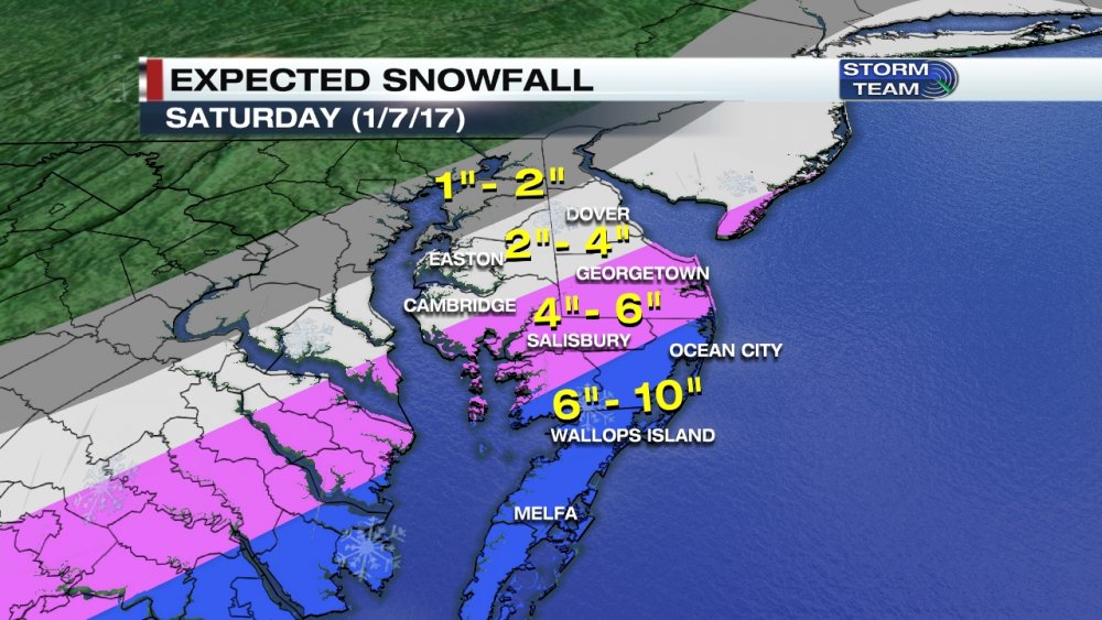
-
Southern MD / Lower Eastern Shore weather discussion
snowdude replied to PrinceFrederickWx's topic in Mid Atlantic
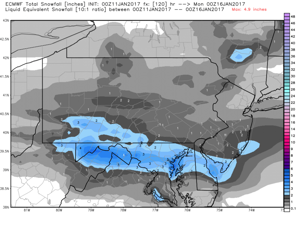
There's going to be a heavy band of snow develop during the morning commute tomorrow and we have watch for where it sets up. Latest information is showing it on eastern shore from Cambridge to Salisbury perhaps. Could lay down some good snow even though stickage may be tough at first. 1-2" is my call for majority of peninsula with exception to coastal towns of a dusting to an inch? Perhaps a heavier band of 2-3"/2-4" somewhere on the shore. -
Southern MD / Lower Eastern Shore weather discussion
snowdude replied to PrinceFrederickWx's topic in Mid Atlantic
Temps will be an issue, but can the column cool with heavier rates? It's going to be a challenge and a close call. -
Southern MD / Lower Eastern Shore weather discussion
snowdude replied to PrinceFrederickWx's topic in Mid Atlantic
My latest forecast... I'm thinking BL temps are going to be very borderline here and accumulation will be tough at first. But I think with decent rates and cold enough air we will see a period of snow. Also, the cold front is slower than forecasted and this MAY cause a bit more of a NW trend which would bring heavier precip into the area and also shift the precip access closer to DC area.
-
Southern MD / Lower Eastern Shore weather discussion
snowdude replied to PrinceFrederickWx's topic in Mid Atlantic
Wow, this is a tough forecast. I am saying a slushy 1"-2" in Salisbury especially on grass. It's going to be tough to stick but if we get the high snow rates like some models are indicating then we could get more. I mean, it's still 62 degrees right now in Salisbury.