snowdude
-
Posts
776 -
Joined
-
Last visited
Content Type
Profiles
Blogs
Forums
American Weather
Media Demo
Store
Gallery
Everything posted by snowdude
-
Southern MD / Lower Eastern Shore weather discussion
snowdude replied to PrinceFrederickWx's topic in Mid Atlantic
I’m getting excited! -
Southern MD / Lower Eastern Shore weather discussion
snowdude replied to PrinceFrederickWx's topic in Mid Atlantic
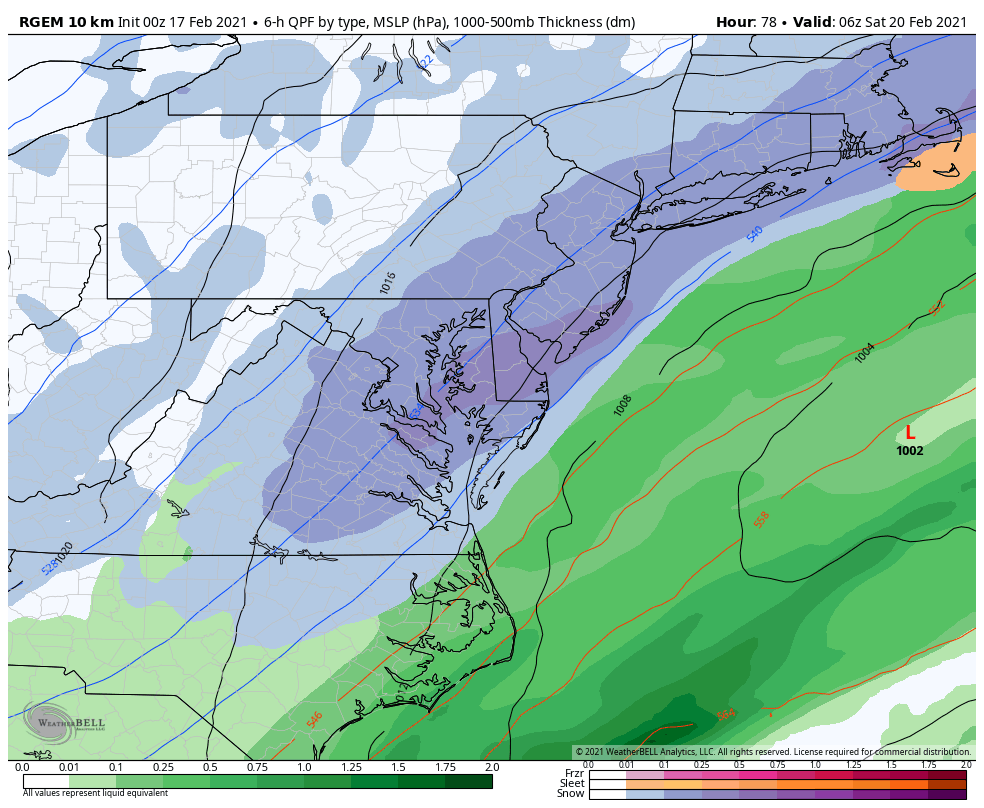
Not holding my breath, but we should also watch the potential for backend snow Friday evening as the coastal low pulls away. RGEM showing a death band, and the Euro shows a similar scenario. Lol. Before that though, lots of sleet looks likely Thursday AM before changing to rain.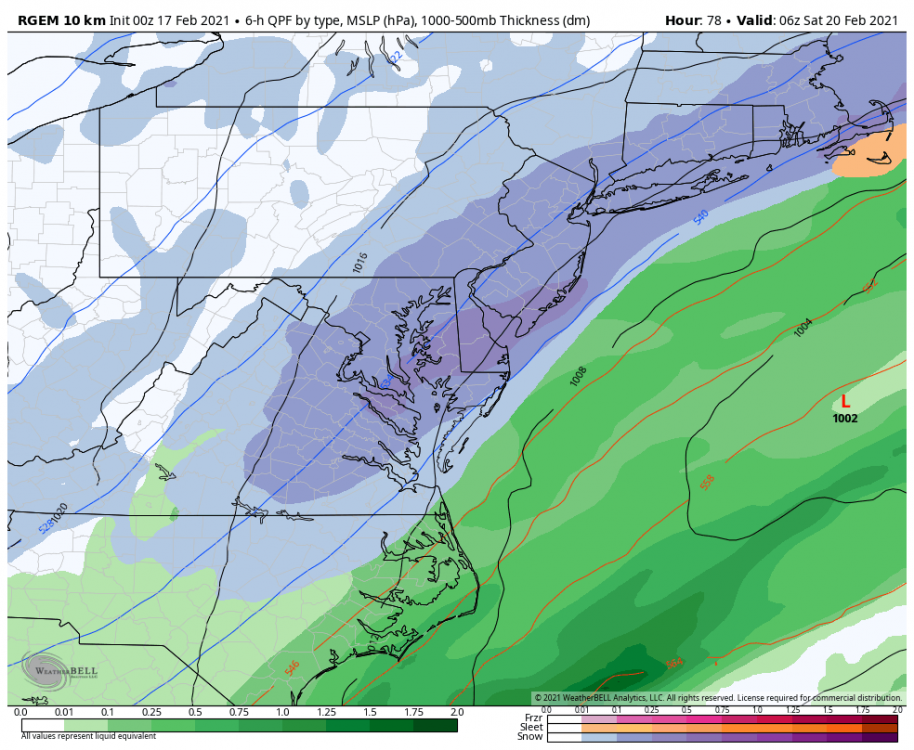
-
Southern MD / Lower Eastern Shore weather discussion
snowdude replied to PrinceFrederickWx's topic in Mid Atlantic
I grew up in northern VA and I remember a couple good ice events in the 90s. Can’t remember exact dates but I’m pretty sure ‘94 was one of them. -
Southern MD / Lower Eastern Shore weather discussion
snowdude replied to PrinceFrederickWx's topic in Mid Atlantic
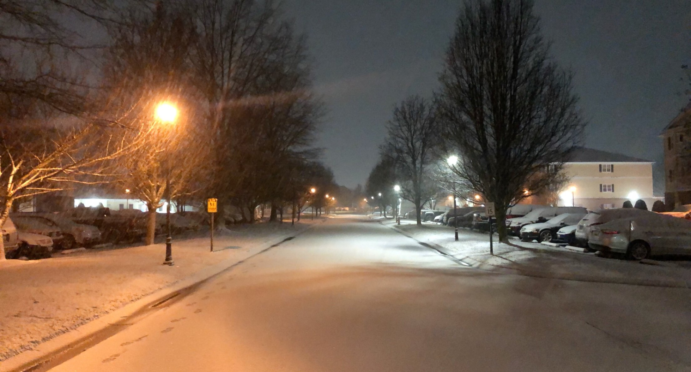
Gorgeous snow here in Salisbury. Went for a stroll at 2am.
-
Southern MD / Lower Eastern Shore weather discussion
snowdude replied to PrinceFrederickWx's topic in Mid Atlantic
I’m frustrated too! It’s really unbelievable how bad the models have been.. -
Southern MD / Lower Eastern Shore weather discussion
snowdude replied to PrinceFrederickWx's topic in Mid Atlantic
It’ll probably snow. And I’m hoping the Thursday night system bumps a bit more north. Definitely possible. I have Salisbury in 1-2 inches, and areas south 2-4. -
Southern MD / Lower Eastern Shore weather discussion
snowdude replied to PrinceFrederickWx's topic in Mid Atlantic
00z Euro holds course!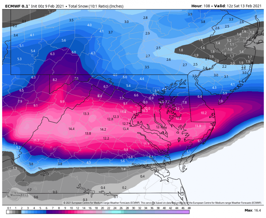
-
Southern MD / Lower Eastern Shore weather discussion
snowdude replied to PrinceFrederickWx's topic in Mid Atlantic
00z run of the NAM lookin good. And still snowing...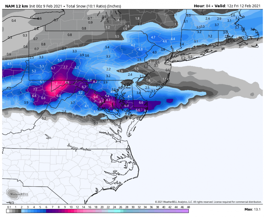
-
Southern MD / Lower Eastern Shore weather discussion
snowdude replied to PrinceFrederickWx's topic in Mid Atlantic
HAHA! You BETTER! We’ve nailed pretty much every storm so far! Very proud of our team! -
Southern MD / Lower Eastern Shore weather discussion
snowdude replied to PrinceFrederickWx's topic in Mid Atlantic
I’m here, I’m here, I’m here! Sorry for being MIA. Total snow for the season in Salisbury is around 7 inches now! Let’s add more to it! Wednesday night-Friday is looking intriguing! The EURO and NAM look kind of similar. When they agree, that’s good. The good ol’ EE rule. EURO & ETA (now the NAM). -
New 00z EURO.
-
Southern MD / Lower Eastern Shore weather discussion
snowdude replied to PrinceFrederickWx's topic in Mid Atlantic
Time to wake up southern Maryland and eastern shore! ❄️ -
Southern MD / Lower Eastern Shore weather discussion
snowdude replied to PrinceFrederickWx's topic in Mid Atlantic
Today's 12z vs 18z euro that just came in.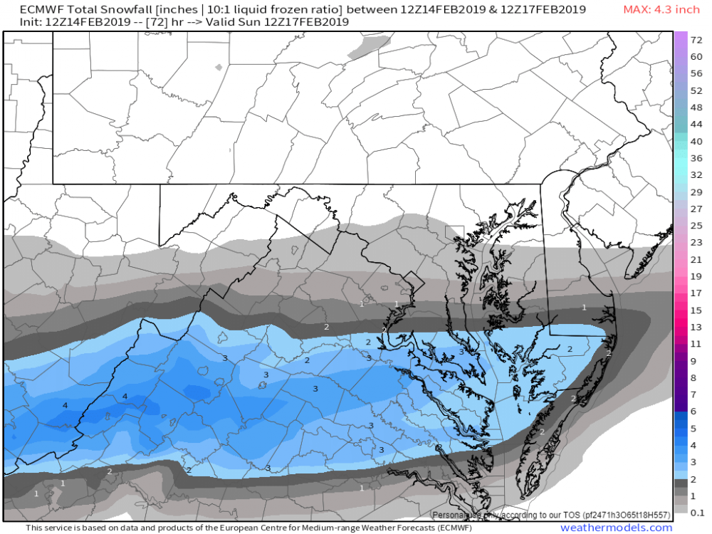

-
Southern MD / Lower Eastern Shore weather discussion
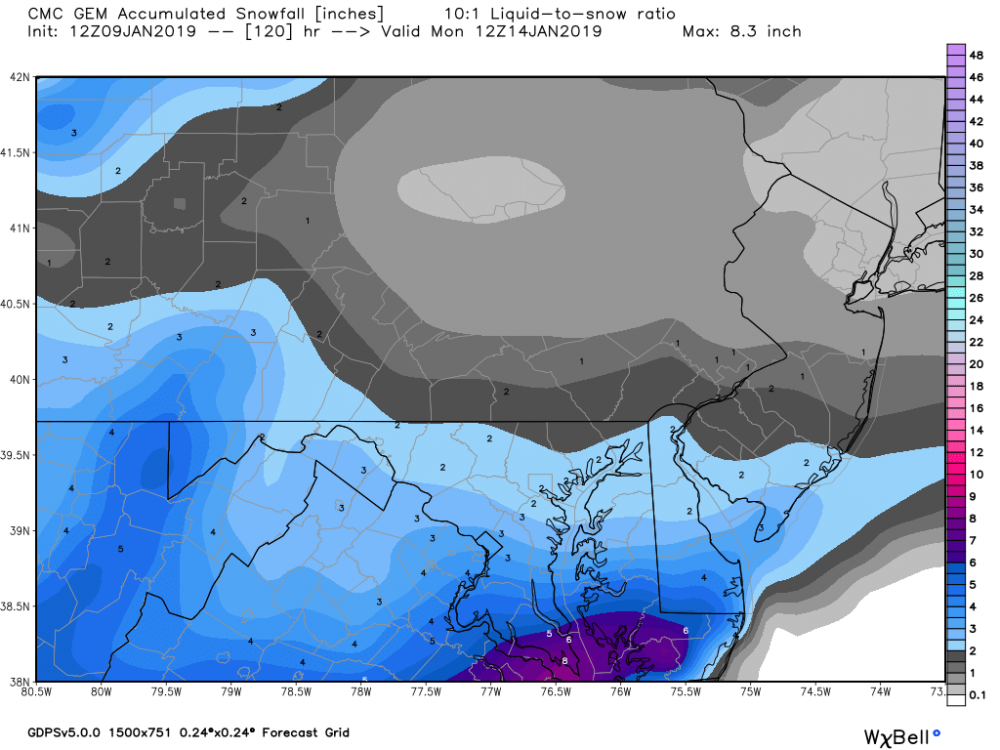
snowdude replied to PrinceFrederickWx's topic in Mid Atlantic
UKMET and NAM a total miss while GFS a hit, CMC getting better, and EURO trended south last night but still some snow. This will be interesting as always. Major model busts coming for some. Deep down I’ve always thought this one will work out for us. Hopefully I’m right! ❄️ -
Southern MD / Lower Eastern Shore weather discussion
snowdude replied to PrinceFrederickWx's topic in Mid Atlantic
Well this upcoming storm on Saturday seems to favor northern Delmarva, but there could be some accumulation into Salisbury. Let's keep tracking! -
Southern MD / Lower Eastern Shore weather discussion
snowdude replied to PrinceFrederickWx's topic in Mid Atlantic
Probably about 3-4 inches of snow in Cambridge this morning. Hoping for some nice banding later. -
Southern MD / Lower Eastern Shore weather discussion
snowdude replied to PrinceFrederickWx's topic in Mid Atlantic
I haven’t been out in an hour or so. We may have over an inch. Looking outside it’s whitened up quite a bit. -
Southern MD / Lower Eastern Shore weather discussion
snowdude replied to PrinceFrederickWx's topic in Mid Atlantic
Moderate snow in Cambridge. It’s a fight between big and small flakes. Everything covered. Probably 3/4”-1” on ground about right now. -
Me too.
-
Southern MD / Lower Eastern Shore weather discussion
snowdude replied to PrinceFrederickWx's topic in Mid Atlantic
Mount Holly and Wakefield (as usual) not performing their best. Doubt it mixes in Easton, and Wakefield has gone from 4-6 inches in Salisbury, back to 3-4, and now back up to 4-6. They had less than an inch in Ocean City and now 2-3 inches there. Storm tonight on 00 guidance is slowling the storm down a bit, maybe ending later Sunday night/Monday morning. We will see! These storms LOVE to overperform. -
Southern MD / Lower Eastern Shore weather discussion
snowdude replied to PrinceFrederickWx's topic in Mid Atlantic
The new 18z Euro is NICE!!! This is 10:1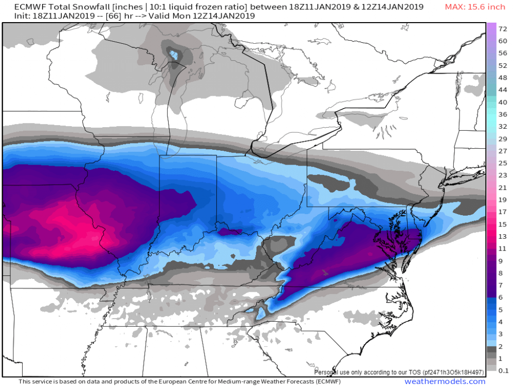
-
Southern MD / Lower Eastern Shore weather discussion
snowdude replied to PrinceFrederickWx's topic in Mid Atlantic
Feeling better about this storm. Watch for the typical last minute northward trends and possibly stronger coastal which could bring higher totals. The RGEM, HRDPS, and NAM looking pretty good. A good 3-6 inches from Salisbury to Cambridge to Georgetown, with 1-3 inches elsewhere. Mixing south of Salisbury and at beaches. Of course potential exists for higher totals. -
Southern MD / Lower Eastern Shore weather discussion
snowdude replied to PrinceFrederickWx's topic in Mid Atlantic
LOL!! 12z GFS and CMC: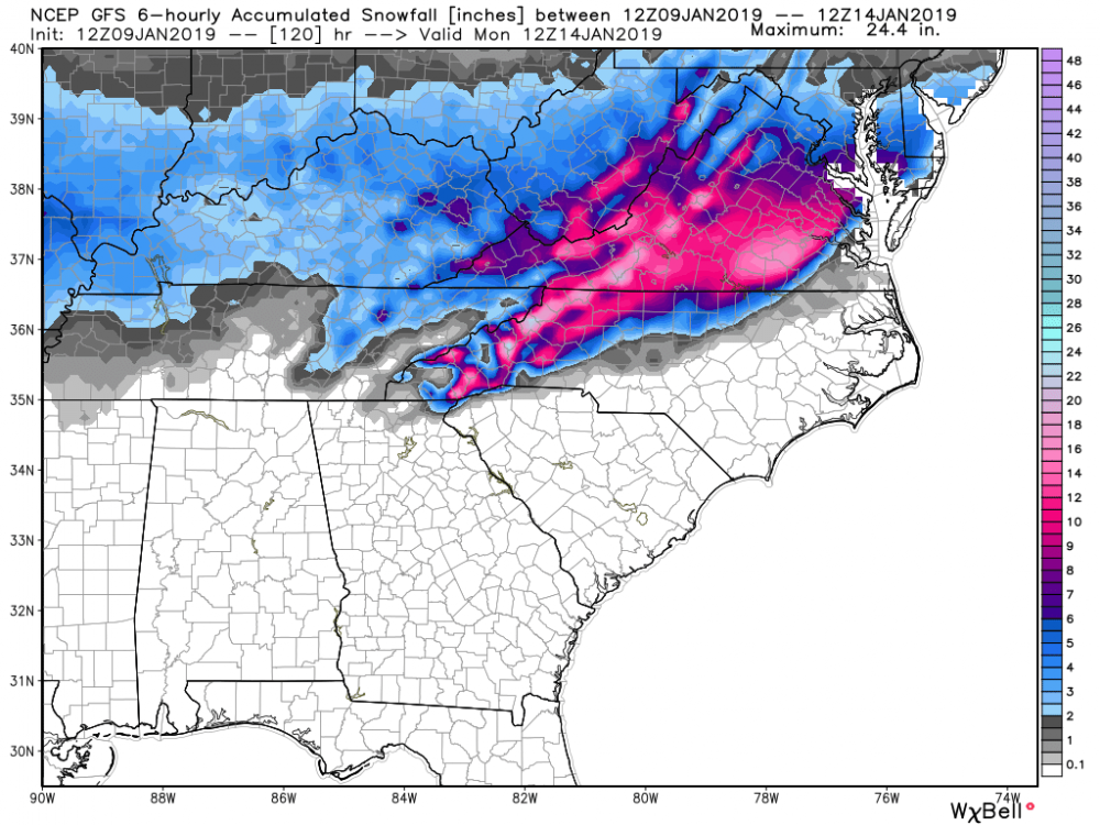
-
Southern MD / Lower Eastern Shore weather discussion
snowdude replied to PrinceFrederickWx's topic in Mid Atlantic
Here. -
Southern MD / Lower Eastern Shore weather discussion
snowdude replied to PrinceFrederickWx's topic in Mid Atlantic
Hey everyone. We had some nice snow here in Cambridge. Snow changed to all sleet late in the evening and stayed sleet through the end. Total snow of 1 inch, maybe a bit more.