

KPITSnow
-
Posts
5,994 -
Joined
-
Last visited
Content Type
Profiles
Blogs
Forums
American Weather
Media Demo
Store
Gallery
Everything posted by KPITSnow
-
Western PA/Pittsburgh Winter 2021/22 Discussion
KPITSnow replied to meatwad's topic in Upstate New York/Pennsylvania
Yeah except we are likely to miss most of the deform band here. This initial push was supposed to be a large portion of our accumulation and if we get 3 inches from it instead of 6 that will greatly reduce our overall total. -
Western PA/Pittsburgh Winter 2021/22 Discussion
KPITSnow replied to meatwad's topic in Upstate New York/Pennsylvania
Unfortunately it is a mix. Check out the traffic cams along 79. -
Western PA/Pittsburgh Winter 2021/22 Discussion
KPITSnow replied to meatwad's topic in Upstate New York/Pennsylvania
Warm air always wins...... -
Western PA/Pittsburgh Winter 2021/22 Discussion
KPITSnow replied to meatwad's topic in Upstate New York/Pennsylvania
I know I'm going to get killed for this but that is basically right over I-70, and I am looking at the traffic cams and it should be a whiteout. Looks like it is not all snow. Hopefully as it pushes north the column will cool. -
Western PA/Pittsburgh Winter 2021/22 Discussion
KPITSnow replied to meatwad's topic in Upstate New York/Pennsylvania
And honestly for the radar, just zoom in on your phone on the thumbnail version. I prefer that to the new radar they have. -
Western PA/Pittsburgh Winter 2021/22 Discussion
KPITSnow replied to meatwad's topic in Upstate New York/Pennsylvania
This is either very heavy snow or heavy sleet.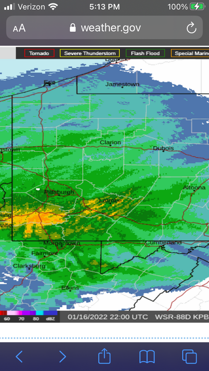
-
Western PA/Pittsburgh Winter 2021/22 Discussion
KPITSnow replied to meatwad's topic in Upstate New York/Pennsylvania
Well we have a poster in here saying they changed over. Like I said, bad sign. -
Western PA/Pittsburgh Winter 2021/22 Discussion
KPITSnow replied to meatwad's topic in Upstate New York/Pennsylvania
Again, bad sign. I was about to say that I was looking at traffic cameras along 70 and for the returns over the area it did not seem to match up rate wise. Sleet? -
Western PA/Pittsburgh Winter 2021/22 Discussion
KPITSnow replied to meatwad's topic in Upstate New York/Pennsylvania
I never trust those, but I do think they use one of the model outputs and just filter that in as the future radar. -
Western PA/Pittsburgh Winter 2021/22 Discussion
KPITSnow replied to meatwad's topic in Upstate New York/Pennsylvania
Radar is really blowing up south of the city, and I don't really see anything that resembles a dry slot developing yet. -
Western PA/Pittsburgh Winter 2021/22 Discussion
KPITSnow replied to meatwad's topic in Upstate New York/Pennsylvania
TO get off my doom and gloom about the storm, I do want to say I really do miss the old NWS radar. The snapshot of it you see before you click into it is still the old radar so I generally just zoom in on my phone. -
Western PA/Pittsburgh Winter 2021/22 Discussion
KPITSnow replied to meatwad's topic in Upstate New York/Pennsylvania
Lol, I likely overreacted a bit. We are SO freaking close to what would really be a historic storm for the area, and its just frustrating that we are likely going to miss it by a matter of 50 miles. -
Western PA/Pittsburgh Winter 2021/22 Discussion
KPITSnow replied to meatwad's topic in Upstate New York/Pennsylvania
They'd be the worst METS ever then. -
Western PA/Pittsburgh Winter 2021/22 Discussion
KPITSnow replied to meatwad's topic in Upstate New York/Pennsylvania
I find it odd that the SPC would issue this but KPIT would drop totals. -
Western PA/Pittsburgh Winter 2021/22 Discussion
KPITSnow replied to meatwad's topic in Upstate New York/Pennsylvania
I never said that. -
Central PA - Winter 2021/2022
KPITSnow replied to Bubbler86's topic in Upstate New York/Pennsylvania
LOL no! I'm just irritated haha. I know this storm isn't yours but getting foot plus storms here is extremely difficult so to waste that chance stinks. -
Central PA - Winter 2021/2022
KPITSnow replied to Bubbler86's topic in Upstate New York/Pennsylvania
If you look at their forecast map they drastically reduced totals on it. Had PIT at 11 inches earlier today and now they are showing 8. I'm guessing we end up with major P type issues and waste the best track we've had in years. -
Western PA/Pittsburgh Winter 2021/22 Discussion
KPITSnow replied to meatwad's topic in Upstate New York/Pennsylvania
It IS going to change over. Saying anything else is wishcasting. -
Western PA/Pittsburgh Winter 2021/22 Discussion
KPITSnow replied to meatwad's topic in Upstate New York/Pennsylvania
Ok then dude. I'll make a bet with you. If KPIT goes over 8 inches I won't post on here the rest of the winter. If it goes under you do the same. -
Central PA - Winter 2021/2022
KPITSnow replied to Bubbler86's topic in Upstate New York/Pennsylvania
This is rapidly falling apart out our way. PIT just drastically cut totals, introduced mixing issues into the forecast, and latest short range models are showing major boundary layer issues. -
Western PA/Pittsburgh Winter 2021/22 Discussion
KPITSnow replied to meatwad's topic in Upstate New York/Pennsylvania
Because it is still interesting. I was told to "shut up" for saying this would be an issue a couple days ago, but talked myself into the fact we would avoid major P type issues but I really should have known better. -
Western PA/Pittsburgh Winter 2021/22 Discussion
KPITSnow replied to meatwad's topic in Upstate New York/Pennsylvania
New HRRR coming out now is showing loads of mixing issues even with the initial slug that was supposed to be all snow. Starting to wonder if we break 6 inches. THe backside might be what needs to save us. -
Western PA/Pittsburgh Winter 2021/22 Discussion
KPITSnow replied to meatwad's topic in Upstate New York/Pennsylvania
With this,anything less than 8 is a massive bust. -
Western PA/Pittsburgh Winter 2021/22 Discussion
KPITSnow replied to meatwad's topic in Upstate New York/Pennsylvania
Shocking. Here we go with our normal bust. Unfreaking real. -
Western PA/Pittsburgh Winter 2021/22 Discussion
KPITSnow replied to meatwad's topic in Upstate New York/Pennsylvania
I just checked their traffic cameras...it is not snowing.


