

WxWatcher007
-
Posts
32,881 -
Joined
-
Last visited
Content Type
Profiles
Blogs
Forums
American Weather
Media Demo
Store
Gallery
Everything posted by WxWatcher007
-
Yeah. I give it respect because it’s the best intensity guidance, but just 24 hours ago it was way too aggressive and in the 24 hours before it was great. Perhaps there’s a window but Elsa would need to really avoid a long journey over the mountains. It’s the best convection for sure. Radar out of Cuba looks pretty interesting too and it’s slowing down just as it hits a very high OHC region. If Elsa’s gonna overperform, it has to do it tonight IMO.
-
It’s pretty hard to tell but my guess is it’s out ahead of the convective burst. It will end up missing SW Haiti though so maybe it’ll get a little organization tonight as it clears the mountain influence and slows a bit. Maybe. Its got an uphill battle. Pun intended Edit: recon en route
-

2021 Atlantic Hurricane Season Tracking Thread
WxWatcher007 replied to WxWatcher007's topic in Mid Atlantic
-
WATCHES AND WARNINGS -------------------- CHANGES WITH THIS ADVISORY: A Tropical Storm Watch is now in effect for the Florida Keys from Craig Key westward to the Dry Tortugas.
-
I’m sure there have been some earlier ones. This one is uncommon because of how soon it developed and how strong it became. I’m sure others were just middling along until they found a more favorable environment in the Gulf and developed.
-
Good thread for those interested in diving deeper.
-
70mph/999mb at 11
-
Yeah—you can’t sugarcoat it. Despite the convective burst near the LLC it’s getting sheared and forward motion only hurts its ability to organize and align itself. It’s hanging on with these bursts and heading to the best OHC environment in the entire basin so I don’t think we can give Elsa last rites or anything like that, but it’s struggling for sure.
-
Night and day appearance compared to yesterday. Definitely an ugly look this morning with the LLC exposed.
-
…if SW Haiti doesn’t do it first…
-
2021 Atlantic Hurricane Season Tracking Thread
WxWatcher007 replied to WxWatcher007's topic in Mid Atlantic
Not sure why I’m posting them since they’ve been terrible but here ya go -
Euro took a step toward the GFS with a westward shift and brings a decent low up verbatim. Still a long way to go though.
-
Awfully disheveled appearance today as the outrageous forward motion takes a toll on Elsa. The most critical part of the forecast period is arriving and will answer what the down range potential is. Will Elsa pinball along the mountains of the Greater Antilles? The first test is SW Haiti later today…
-
2021 Atlantic Hurricane Season Tracking Thread
WxWatcher007 replied to WxWatcher007's topic in Mid Atlantic
Took forever, but the euro finally caught onto the track. Should be impacts up the coast but a lot is dependent on the next 24-36 hours and land interaction. -
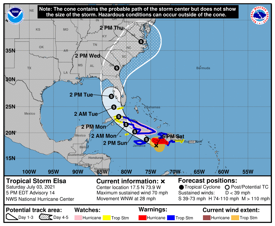
Fantastic discussion tonight. Hurricane Elsa Discussion Number 11 NWS National Hurricane Center Miami FL AL052021 1100 PM AST Fri Jul 02 2021 Data from an Air Force Reserve hurricane hunter aircraft indicate that Elsa has weakened slightly, and that the flight-level and surface centers are not vertically aligned. The maximum 700-mb wind speed measured was 75 kt and the highest SFMR surface wind sampled was 61 kt in the northeastern quadrant. However, these data were collected outside of the strongest convection that was occurring just east of the flight track, so the intensity has only been lowered to 70 kt, which is supported by the slightly higher central pressure of 995 mb sampled by a dropsonde. The initial motion estimate now is 285/25 kt. There remains little significant change to the previous track forecast or reasoning. The latest 00Z model guidance has become more convergent and now lies nearly on top of the previous advisory track. Over the last 48 h, the ECMWF model has steadily shifted Elsa's track westward by about 1 degree of longitude each model cycle, with the latest ECMWF forecast track now being located about 240 nmi west of its forecast track two days ago. As a result, less weight has been placed on the ECMWF solution for this advisory. However, even its latest solution no longer takes Elsa over the heart of Hispaniola. Elsa should continue to move generally west-northwestward for the next 48 h, accompanied by a slow but steady decrease in forward speed. By the time the hurricane nears southern Cuba, the forward speed should be less than 15 kt. Thereafter, Elsa should gradually turn northwestward and eventually northward through a developing weakness in the subtropical ridge This motion should take Elsa across Cuba and over the eastern Gulf of Mexico or the nearby Florida Peninsula on day 4, followed by a motion over the coastal regions of the southeastern United States on day 5. The new NHC forecast track is essentially just an update of the previous advisory, and closely follows a blend of the GFS, UKMET, and HWRF models, and the TVCA simple consensus model. Elsa's fast forward speed and recent entrainment of dry mid-level air into the western semicircle has eroded some of the inner-core convection, resulting in the aforementioned weakening. In fact, NOAA G-IV dropsondes launched around 2100 UTC northwest of Elsa indicated a significant dry-air layer between 400-500-hPa that may have been imported by moderate northwesterly mid-level shear. However, as the cyclone's forward speed steadily decreases, the low-, mid-, and upper-level circulations should become more vertically aligned, which should allow for at least some slight re-strengthening during the next 24 h or so. Possible interaction with the landmasses of Haiti, southeastern Cuba, and Jamaica is the primary reason for not showing a more robust intensity forecast given the very warm water beneath the hurricane and a very favorable upper-level wind flow regime. The latest GFS and UKMET models indicate that Elsa will be moving into the center of a 300-200-mb synoptic-scale anticyclone, which would produce enhanced outflow jets to the north and south of the cyclone, resulting in significant strengthening. If Elsa ends up 'threading-the-needle' between Haiti, Jamaica, and Cuba, then subsequent intensity forecasts may have to be increased similar to the much stronger HWRF model. For now, the official NHC intensity forecast maintains continuity with the previous advisory, and shows only slight re-strengthening due to possible interaction with land. It should be noted that the average NHC track errors are 175 miles and 200 miles at days 4 and 5, respectively. Given the larger-than-normal uncertainty and because hazards will extend well away from the center of the storm, users are urged to not focus on the exact forecast points. Key Messages: 1. Hurricane conditions and dangerous storm surge are expected within the Hurricane Warning areas in Haiti and the Dominican Republic beginning Saturday and in Jamaica beginning Sunday. 2. The outer rain bands from Elsa will impact Puerto Rico by late tonight, with widespread heavy rain moving into southern Hispaniola and Jamaica Saturday into Sunday. Isolated to scattered flash flooding and mudslides are possible. Through early next week, heavy rain is expected to impact the Cayman Islands and Cuba resulting in significant flooding with mudslides possible in Cuba. 3. Hurricane conditions and dangerous storm surge are possible in portions of eastern Cuba beginning early Sunday where a Hurricane Watch is in effect. There is an increasing risk of wind, storm surge, and rainfall impacts elsewhere in Cuba Sunday and Monday. 4. There is an increasing risk of storm surge, wind, and rainfall impacts beginning Monday in the Florida Keys and spreading northward along the Florida Peninsula through Tuesday. However, the forecast uncertainty remains larger than usual due to Elsa's potential interaction with the islands of Hispaniola and Cuba this weekend. Interests throughout Florida should monitor Elsa's progress and updates to the forecast. FORECAST POSITIONS AND MAX WINDS INIT 03/0300Z 14.8N 66.3W 70 KT 80 MPH 12H 03/1200Z 16.1N 69.8W 70 KT 80 MPH 24H 04/0000Z 17.6N 73.5W 75 KT 85 MPH 36H 04/1200Z 19.0N 76.2W 75 KT 85 MPH 48H 05/0000Z 20.5N 78.5W 70 KT 80 MPH 60H 05/1200Z 22.1N 80.4W 55 KT 65 MPH...INLAND 72H 06/0000Z 23.7N 81.7W 55 KT 65 MPH...OVER WATER 96H 07/0000Z 27.7N 82.9W 50 KT 60 MPH 120H 08/0000Z 32.4N 80.7W 35 KT 40 MPH...INLAND $$ Forecaster Stewart/Papin
-
Wanted to make sure I got to this. I’m really simplifying it but basically the deep convection/cold cloud tops near the center are a sign that a tropical system is capable of intensifying. Think of the dynamics already at play in the center of a tropical system. When the air rises in convection, it translates to lower pressure and when you get these areas of tremendous lift near the center, it can allow for organization of an inner core which makes more efficient use of the mechanisms that create hurricanes. Importantly, it takes time for the “chain reaction” to become self sustaining. That’s again a huge oversimplification, but it’s the general idea.
-
Center sonde Product: Air Force Temp Drop (Dropsonde) Message (UZNT13 KNHC)Transmitted: 3rd day of the month at 0:01ZAgency: United States Air ForceAircraft: Lockheed WC-130J Hercules with reg. number AF97-5304Storm Name: ElsaStorm Number: 05 (flight in the North Atlantic basin)Mission Number: 4Observation Number: 04 ( See all messages of this type for this mission. )Part A... Date: Near the closest hour of 0Z on the 3rd day of the month Highest Mandatory Level For Which Wind Was Reported: 850mb Coordinates: 14.4N 65.1W Location: 284 statute miles (458 km) to the SSE (167°) from San Juan, Puerto Rico (U.S.). Marsden Square: 043 ( About ) Surface and Standard Isobaric Surfaces Level Geo. Height Air Temp. Dew Point Wind Direction Wind Speed 1000mb -13m (-43 ft) This level does not exist in this area of the storm above the surface level. 999mb (29.50 inHg) Surface (Sea Level) 26.8°C (80.2°F) 26.0°C (79°F) 205° (from the SSW) 23 knots (26 mph) 925mb 675m (2,215 ft) 23.6°C (74.5°F) 22.2°C (72°F) 225° (from the SW) 21 knots (24 mph) 850mb 1,413m (4,636 ft) 20.0°C (68.0°F) 19.1°C (66°F) 260° (from the W) 12 knots (14 mph) 700mb Information Unavailable Information About Radiosonde: - Launch Time: 23:45Z - About Sonde: A descending radiosonde tracked automatically by satellite navigation with no solar or infrared correction. Remarks Section... Dropsonde Location: Dropped in center. Highest altitude where wind was reported: - Location: 14.46N 65.16W - Time: 23:45:16Z Lowest altitude where wind was reported: - Location: 14.40N 65.09W - Time: 23:49:48Z Mean Boundary Level Wind (mean wind in the lowest 500 geopotential meters of the sounding): - Wind Direction: 210° (from the SSW) - Wind Speed: 27 knots (31 mph) Deep Layer Mean Wind (average wind over the depth of the sounding): - Wind Direction: 240° (from the WSW) - Wind Speed: 12 knots (14 mph) - Depth of Sounding: From 708mb to 998mb Average Wind Over Lowest Available 150 geopotential meters (gpm) of the sounding: - Lowest 150m: 154 gpm - 4 gpm (505 geo. feet - 13 geo. feet) - Wind Direction: 205° (from the SSW) - Wind Speed: 26 knots (30 mph) Sounding Software Version: AEV 30404
-
8pm update 85mph 995mb Recon found 996.3 mb extrapolated recently
-
2021 Atlantic Hurricane Season Tracking Thread
WxWatcher007 replied to WxWatcher007's topic in Mid Atlantic
Enjoy your tropical lol -
Recon descending into hurricane now. IR presentation had degraded a bit but microwave imagery is mixed on the current organization of the inner core.
-
Really happy to see that we have high altitude recon out there right now sampling the environment ahead and around the hurricane. That'll be important for the guidance even as today it seems that the guidance has narrowed a bit. Low level recon flight is en route and should be there shortly.
-
2021 Mid-Atlantic Severe Weather - General Discussion
WxWatcher007 replied to Kmlwx's topic in Mid Atlantic
-
Just created one. Not all of your posts are off topic IMO, so I hope you continue to provide your local perspective here too.
-
For banter.
-
We have a new VDM Product: NOAA Vortex Message (URNT12 KWBC)Transmitted: 2nd day of the month at 18:44ZAgency: National Oceanic and Atmospheric Administration (NOAA)Aircraft: Lockheed WP-3D Orion (Reg. Num. N42RF)Storm Name: ElsaStorm Number & Year: 05 in 2021 (flight in the North Atlantic basin)Mission Number: 2Observation Number: 08 ( See all messages of this type for this mission. )A. Time of Center Fix: 2nd day of the month at 17:55:14ZB. Center Fix Coordinates: 13.75N 62.40WB. Center Fix Location: 89 statute miles (143 km) to the WNW (297°) from Kingstown, Saint Vincent and the Grenadines.C. Minimum Height at Standard Level: 3,070m (10,072ft) at 700mbD. Minimum Sea Level Pressure: 993mb (29.33 inHg)E. Dropsonde Surface Wind at Center: From 130° at 28kts (From the SE at 32mph)F. Eye Character: Not AvailableG. Eye Shape: Not AvailableH. Estimated (by SFMR or visually) Maximum Surface Wind Inbound: 68kts (78.3mph)I. Location & Time of the Estimated Maximum Surface Wind Inbound: 6 nautical miles to the NE (54°) of center fix at 17:50:18ZJ. Maximum Flight Level Wind Inbound: From 92° at 70kts (From the E at 80.6mph)K. Location & Time of the Maximum Flight Level Wind Inbound: 69 nautical miles (79 statute miles) to the NNW (336°) of center fix at 17:31:45ZL. Estimated (by SFMR or visually) Maximum Surface Wind Outbound: 57kts (65.6mph)M. Location & Time of the Estimated Maximum Surface Wind Outbound: 6 nautical miles to the ESE (120°) of center fix at 17:57:14ZN. Maximum Flight Level Wind Outbound: From 164° at 49kts (From the SSE at 56.4mph)O. Location & Time of the Maximum Flight Level Wind Outbound: 67 nautical miles (77 statute miles) to the SSE (147°) of center fix at 18:14:01ZP. Maximum Flight Level Temp & Pressure Altitude Outside Eye: 9°C (48°F) at a pressure alt. of 3,067m (10,062ft)Q. Maximum Flight Level Temp & Pressure Altitude Inside Eye: 17°C (63°F) at a pressure alt. of 3,039m (9,970ft)R. Dewpoint Temp (collected at same location as temp inside eye): 7°C (45°F)R. Sea Surface Temp (collected at same location as temp inside eye): Not AvailableS. Fix Determined By: Penetration, Wind, Pressure and TemperatureS. Fix Level: 700mbT. Navigational Fix Accuracy: 0.01 nautical milesT. Meteorological Accuracy: 4 nautical milesRemarks Section - Remarks That Were Decoded... Maximum Flight Level Wind: 70kts (~ 80.6mph) which was observed 69 nautical miles (79 statute miles) to the NNW (336°) from the flight level center at 16:34:33Z Remarks Section - Additional Remarks... Sur press from dropsonde.


