

WxWatcher007
-
Posts
32,881 -
Joined
-
Last visited
Content Type
Profiles
Blogs
Forums
American Weather
Media Demo
Store
Gallery
Everything posted by WxWatcher007
-

2021 Atlantic Hurricane Season Tracking Thread
WxWatcher007 replied to WxWatcher007's topic in Mid Atlantic
I can’t see the tweet, but I saw today that this is about as strong a long range signal for US threats as I’ve ever seen for the peak of a hurricane season. -
Tropical Depression Fred Discussion Number 17 NWS National Hurricane Center Miami FL AL062021 500 PM EDT Fri Aug 13 2021 Although there has been a general increase in convection associated with Fred since this morning, the system remains disorganized with the low-level center moving farther inland over central Cuba. Earlier ASCAT data detected an area of 25-27 kt winds over water to the northeast of the center, and based on that data, the initial intensity is held at 30 kt, which could be a little generous. Since the previous advisory, Fred has been moving nearly due westward, but the longer-term motion is estimated to be 280/10 kt. The cyclone is nearing the western periphery of a subtropical ridge that is centered over the western Atlantic. This should cause Fred to turn west-northwestward tonight, and then northwestward on Saturday. The latest interpolated guidance that was initialized with the more southward and westward 18Z initial position shows a wider or more gradual northwestward turn, and therefore has shifted significantly westward, especially in the short term. However, the global models fields track the 850-mb vorticity center more along the northern coast of Cuba and some of those models suggest a center re-formation could occur on Saturday near the north coast of Cuba or over the Straits of Florida. As a result, the first 24-36 hours of the track forecast has been adjusted about a degree westward, but it is not as far west as the trackers, leaving open the possibility that a center re-formation could occur. After that time, the NHC forecast lies along the eastern side of the guidance envelope in best agreement with the 12Z GFS. Some additional westward adjustments may be necessary until the track guidance stabilizes. It is worth noting that it isn't too surprising to see these type of models shifts with a system that remains quite disorganized. Fred remains within an area of moderate southwesterly vertical wind shear, and the model guidance generally indicates that this shear will continue during the next day or so. Since it will also take time for the system to recover after its passage over Cuba, only gradual strengthening is indicated during the next day or two. After that time, the system could be in a somewhat more favorable environment, and the NHC intensity forecast calls for some strengthening until Fred reaches the northern Gulf Coast, which now doesn't occur until around 72 hours with the wider turn shown in the track forecast. The NHC intensity forecast lies between the various consensus aids, the statistical guidance, and the HWRF model, which all generally show the system peaking in 60-72 hours. The intensity forecast remains of lower-than-normal confidence due to Fred's continued interaction with land. Users are reminded to not focus on the exact forecast track as heavy rainfall, gusty winds, and a chance of tornadoes will extend far to northeast and east of the center, and those hazards are likely to still affect portions of the Florida peninsula, despite the recent shift in the forecast track. KEY MESSAGES: 1. Today through Monday, heavy rainfall could lead to areal, urban, small stream, and exacerbated river flooding across southern and central Florida into the Big Bend. From Sunday onward, heavy rain and flood impacts could extend into other portions of the Southeast and into the southern and central Appalachians and Piedmont as Fred interacts with a front in that area. 2. Tropical storm conditions are expected in portions of the Florida Keys on Saturday, where a Tropical Storm Warning is in effect. 3. Tropical storm conditions are possible late Saturday and early Sunday across portions of the west coast of Florida in the Tropical Storm Watch area. The risk of tropical storm conditions will spread northward along the Florida west coast and to the Florida Panhandle Sunday and Monday. FORECAST POSITIONS AND MAX WINDS INIT 13/2100Z 22.3N 79.6W 30 KT 35 MPH...INLAND 12H 14/0600Z 23.0N 81.0W 30 KT 35 MPH...INLAND 24H 14/1800Z 24.2N 82.6W 35 KT 40 MPH...OVER WATER 36H 15/0600Z 25.4N 83.7W 35 KT 40 MPH 48H 15/1800Z 27.0N 84.8W 40 KT 45 MPH 60H 16/0600Z 28.8N 85.7W 45 KT 50 MPH 72H 16/1800Z 30.2N 86.2W 50 KT 60 MPH 96H 17/1800Z 33.5N 86.5W 25 KT 30 MPH...INLAND 120H 18/1800Z 37.0N 85.0W 20 KT 25 MPH...POST-TROP/INLAND $$ Forecaster Brown
-
I’m not convinced yet the steering pattern will be there to slingshot this up the coast. That trough could just as easily be timed or oriented to be a kicker or too shallow to allow anything north of the Outer Banks. If I had to speculate at this range, I’d go with the latter. Of course, it has to miss the Greater Antilles first guys
-
2021 Atlantic Hurricane Season Tracking Thread
WxWatcher007 replied to WxWatcher007's topic in Mid Atlantic
I remember. I chiseled a lot of tombstones in my day. -
I think the guidance handles the sparse data area fine—it’s really a question IMO of can they handle a developing wave because errors grow exponentially when initialization is wrong.
-
Keep in mind that TC intensity is not static. This could lose its LLC and become an open wave, but a robust wave with strong mid level spin could still regenerate in a more favorable environment. It’s not surprising Fred looks terrible now, but the eastern Gulf looks more conducive for organization and/or intensification with a reduced shear environment. Hadn’t looked until now but I don’t think anything comes of that. Too much wind shear to the north and sometimes convection blows up and collapses after a few hours.
-
2021 Atlantic Hurricane Season Tracking Thread
WxWatcher007 replied to WxWatcher007's topic in Mid Atlantic
Toss the op guidance -
When PTC 7 organized itself further north, it put itself at greater peril for a greater Antilles strike, but also increased the odds for an East Coast impact. I think this one has a high ceiling somewhere if it avoids the Fred path. A lot to sort out. Toss the operational guidance for now.
-
-
2021 Atlantic Hurricane Season Tracking Thread
WxWatcher007 replied to WxWatcher007's topic in Mid Atlantic
LOL NHC must have heard me -
100% I think this has a high ceiling if it avoids the Fred route, but there’s a lot to sort out still. I do think we see a PTC designation later today, especially if that new convective burst upshear can hold. Edit: welp
-
It’s barely hanging on as a TC, but I guess that opens the door for a possible reformation nearer the convection south of Cuba. Doesn’t really change the impacts for S FL though.
-
2021 Atlantic Hurricane Season Tracking Thread
WxWatcher007 replied to WxWatcher007's topic in Mid Atlantic
All kidding aside, I’ve been intrigued by 95L for a while. Fred is struggling in large part because it ran itself through the mountains of DR/Haiti, but if 95L can avoid that fate, it has a high ceiling IMO. Probably gets designated as a PTC later today. -
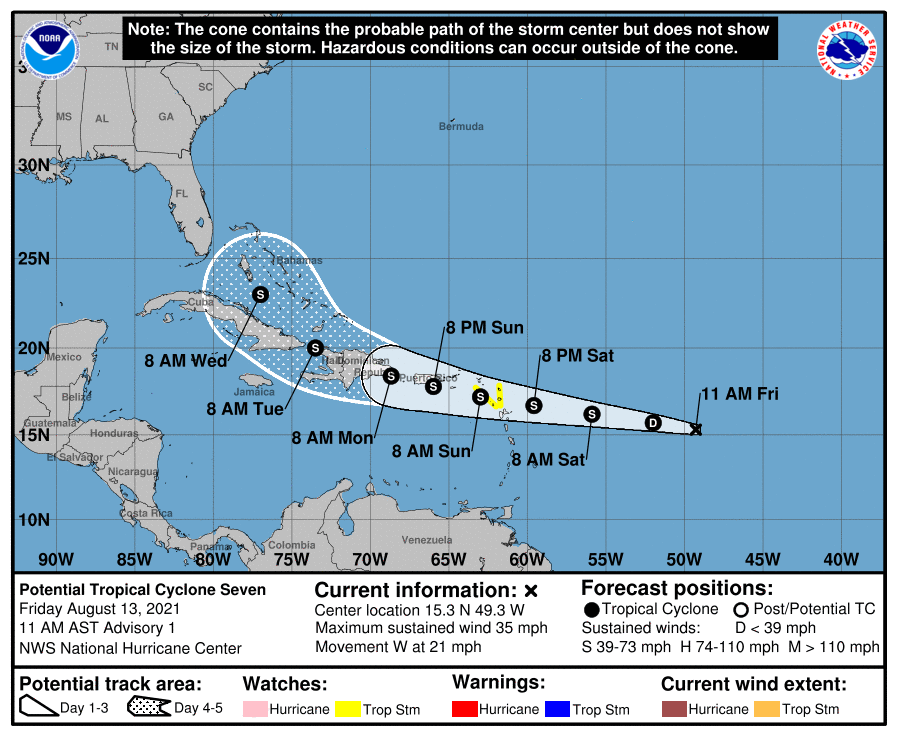
Could see advisories later today… Tropical Weather Outlook NWS National Hurricane Center Miami FL 800 AM EDT Fri Aug 13 2021 For the North Atlantic...Caribbean Sea and the Gulf of Mexico: The National Hurricane Center is issuing advisories on Tropical Depression Fred, located near the north-central coast of Cuba. 1. Showers and thunderstorms have become a little better organized since yesterday near an area of low pressure located about 850 miles east of the Lesser Antilles. Environmental conditions are becoming more conducive for additional development, and a tropical depression is likely to form over the next day or two while moving toward the west or west-northwest at about 20 mph. This system is expected to reach portions of the Leeward Islands Saturday night and then the Virgin Islands and Puerto Rico Sunday and Sunday night. Tropical storm watches or warnings could be required later today or tonight for portions of the Leeward Islands, the Virgin Islands, and Puerto Rico, since strong winds and heavy rainfall are likely to spread across those areas over the weekend, regardless of the system's development. Interests in these areas should continue to monitor the progress of this disturbance. * Formation chance through 48 hours...high...80 percent. * Formation chance through 5 days...high...80 percent. Forecaster Berg
-
2021 Atlantic Hurricane Season Tracking Thread
WxWatcher007 replied to WxWatcher007's topic in Mid Atlantic
If you liked that run, you’ll LOVE the 00z run -
Michael is not walking through the door.
-
I think topping out at 75-80 mph in the Gulf is in the reasonable (but outlier) range of possibilities but to me it seems most likely it’s 60-65 mph there. You’re right though that it’s in a tricky spot.
-
Here’s the VDM from recon. Still disorganized, but very close to retaining TS status based on SFMR readings. Shear is still making organization difficult, but the convective burst is nice. Product: Air Force Vortex Message (URNT12 KNHC)Transmitted: 13th day of the month at 1:14ZAgency: United States Air Force Aircraft: Lockheed WC-130J Hercules with reg. number AF97-5304 Storm Name: FredStorm Number & Year: 06 in 2021 (flight in the North Atlantic basin)Mission Number: 8Observation Number: 04 ( See all messages of this type for this mission. )A. Time of Center Fix: 13th day of the month at 0:51:00ZB. Center Fix Coordinates: 21.36N 75.30WB. Center Fix Location: 99 statute miles (159 km) to the NNE (20°) from Santiago de Cuba, Cuba.C. Minimum Height at Standard Level: 798m (2,618ft) at 925mbD. Minimum Sea Level Pressure: 1013mb (29.92 inHg) - ExtrapolatedE. Dropsonde Surface Wind at Center (Undecoded): NAF. Eye Character: Not AvailableG. Eye Shape: Not AvailableH. Estimated (by SFMR or visually) Maximum Surface Wind Inbound: 33kts (38.0mph)I. Location & Time of the Estimated Maximum Surface Wind Inbound: 32 nautical miles (37 statute miles) to the N (5°) of center fix at 0:40:30ZJ. Maximum Flight Level Wind Inbound: From 114° at 42kts (From the ESE at 48.3mph)K. Location & Time of the Maximum Flight Level Wind Inbound: 39 nautical miles (45 statute miles) to the N (10°) of center fix at 0:38:00ZL. Estimated (by SFMR or visually) Maximum Surface Wind Outbound: 15kts (17.3mph)M. Location & Time of the Estimated Maximum Surface Wind Outbound: 36 nautical miles (41 statute miles) to the W (269°) of center fix at 1:03:00ZN. Maximum Flight Level Wind Outbound: From 54° at 13kts (From the NE at 15.0mph)O. Location & Time of the Maximum Flight Level Wind Outbound: 48 nautical miles (55 statute miles) to the W (270°) of center fix at 1:06:30ZP. Maximum Flight Level Temp & Pressure Altitude Outside Eye: 19°C (66°F) at a pressure alt. of 761m (2,497ft)Q. Maximum Flight Level Temp & Pressure Altitude Inside Eye: 21°C (70°F) at a pressure alt. of 761m (2,497ft)R. Dewpoint Temp (collected at same location as temp inside eye): 20°C (68°F)R. Sea Surface Temp (collected at same location as temp inside eye): Not AvailableS. Fix Determined By: Penetration, Wind, Pressure and TemperatureS. Fix Level: 925mbT. Navigational Fix Accuracy: 0.02 nautical milesT. Meteorological Accuracy: 10 nautical milesRemarks Section: Maximum Flight Level Wind: 42kts (~ 48.3mph) which was observed 39 nautical miles (45 statute miles) to the N (10°) from the flight level center at 0:38:00Z Sea Level Pressure Extrapolation From: 925mb
-
2021 Atlantic Hurricane Season Tracking Thread
WxWatcher007 replied to WxWatcher007's topic in Mid Atlantic
This is a really helpful illustration of what to look for in developing but sheared tropical systems. You can see this very clearly tonight with Fred, as the convection is held downshear and cannot wrap around the LLC. It’s very hard to get significant organization and eventual intensification without this alignment process taking place. It’s easier to see on visible but we can make it work. Basically shear is generally pushing Fred’s convection from west to east, so you can see that despite the convective blowup, it remains downshear, and isn’t wrapping or firing to the west of the center. Let’s compare to Linda in the eastern Pacific. Obviously a good bit stronger but why is that? Note how the deepest convection is at the right/north side of the center at the very beginning, but wraps around the center. This process allows for the “feedback loop” of pressure drops and wind increases that allow for intensification. In a lower shear environment, Linda is able to vertically align and fully wrap convection around a core. This is why wind shear and vector is so important to TC genesis and intensification in a nutshell. -
It does look like it’s trying to align under the convection, but it’s still got work to do to achieve that. No significant pressure drop on the latest pass by recon.
-
We were all there once. I learned so much getting on the early wx boards at that age and following some of the pros and knowledgeable hobbyists. The great thing about this place is if you’re in the right threads, there’s something to be learned or a perspective to be gained.
-
Recon is in the system right now, so we should get some data on this convective burst and organization of the storm. So far, I don’t see any real pressure drops.
-
Honestly, I'd be surprised if he attempted a chase here. It just looks too disorganized and marginal on guidance to get someone like him going. I know I'm not considering this one. This. It's obviously something to track but 1) there's nothing too exciting happening right now IMO and 2) there are a lot of tropical snobs on the board. Some only show up if there's a major (wind) event in the cards. That said, let's talk tropical I've been lukewarm on Fred's future, and it seems that the guidance has pulled back as well. Keep in mind that runs like the HWRF and that one GFS run were outliers, and even GEFS and EPS guidance were more bearish on the possibilities of a strong system coming into Florida. To be clear, Fred is not dead. It has developed a pretty impressive burst of convection. However, you can see clearly from the visible loop below that shear is present, as the cloud tops are being blown away from the center. Despite the very warm SSTs and OHC, it's going to take time for a weakened Fred to be in a low enough shear environment to allow for any type of significant intensification. That's why the current NHC forecast doesn't get this to hurricane or even high end TS status. One caveat could be if Fred is able to avoid land interaction (GFS and Euro take it into the FL Peninsula before getting to the Gulf) perhaps it can intensify a bit more because it'll have more time, but I think the ceiling is minimal hurricane if everything became aligned. I think a mid-strength TS much like the NHC is forecasting is the eventual outcome, and it should be mentioned again that this looks to be a significant rainmaker for someone.
-
We've been watching for a few days now but the organization of Invest 95L has improved today, moving the NHC to increase 5-day development odds to 70%. Like Elsa and Fred, 95L is projected to follow a similar path, though there is still (obviously) a lot to be resolved with regard to eventual path and intensity. Given the steering pattern, this could be a threat to the Greater Antilles this weekend and the US as early as next week. Time to track with a separate thread. Tropical Weather Outlook NWS National Hurricane Center Miami FL 200 PM EDT Thu Aug 12 2021 For the North Atlantic...Caribbean Sea and the Gulf of Mexico: The National Hurricane Center is issuing advisories on Tropical Depression Fred, located about 105 miles west of Great Inagua, Bahamas. 1. Satellite-derived wind data from this morning indicated that a small area of low pressure has developed along a tropical wave about 1200 miles east of the Lesser Antilles. However, the low does not quite have a closed circulation, and the associated shower and thunderstorm activity remains disorganized. Environmental conditions are expected to become more conducive for additional development, and a tropical depression is likely to form by the weekend while moving generally westward at about 20 mph across the tropical Atlantic. This system is expected to reach portions of the Leeward Islands late Saturday or early Sunday, and interests there should monitor its progress. * Formation chance through 48 hours...medium...60 percent. * Formation chance through 5 days...high...70 percent. Forecaster Berg
-
I appreciate that and to be clear, I’m not trying to be dramatic or take a shot at mods or anyone who wants to go off topic without going overboard. For most people, what happens here stays here and the overwhelming majority of the conversation that I’ve seen is fine. But that other part is tough.


