

TauntonBlizzard2013
-
Posts
34,197 -
Joined
-
Last visited
Content Type
Profiles
Blogs
Forums
American Weather
Media Demo
Store
Gallery
Everything posted by TauntonBlizzard2013
-
 This could be a storm where there is a decent difference between my house and my work (Stonehill college) like 7 miles up 138
 -
I like 4-8”....” the taint is closer than it appears”.
-
@CoastalWx Too tough to call here? NAM is a shellacking of like a foot of paste and ends as drizzle. That’s probably best case. Other models get the mix in here still during the meat.
-
Box going with heavy taint south and south east of Boston
-
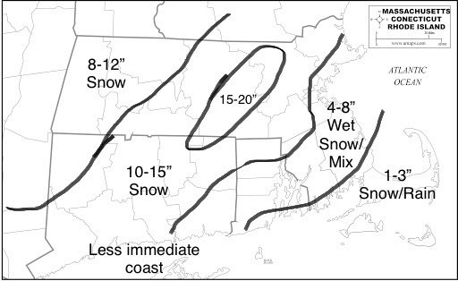
FINAL CALL:
-
Such a tough forecast down here.... wouldn’t be surprised with 3” or 12”
-
We’ll see what happens. The gfs still doesn’t have it snowing until like 3pm or a bit later in eastern ma. CT a different story
-
Canadian still seems like garbage here
-
Is it worth signing the agreements to enable real time data on TD?
-
Think or swim is pretty cool. That just seems like a better version of the actual app... seems like you can whatever you need on that
-
Opened a TD Ameritrade account... took like 10 mins. I believe I have ability to trade pre and post market
-
Yeah... I’ve heard similar stories... I might drop $100 bucks on AMC Monday
-
Looks basically 7p to 7a in eastern ma
-
I’m hoping I can build that couple hundred and just keep reinvesting it... my buddy started with $100 bucks last year and he now has over 1k invested just on what he made
-
The melts would be literal all timer stuff. Ants squad car buried up to the mirrors while Ray bails out the foot of rainwater in his basement.
-
Yeah... that was in jest.. I’m sure you’ll be fine at your local. In all seriousness, we are probably cooked here unless we see some major changes tonight and tomorrow 12z
-
Still time for it to get to you too. Long ways to go.
-
You’re like the grim reaper lurking in the shadows. You’ve mostly sat this one out, and now here comes the shock and awe that you’re going to get crushed. “Dumbfounded”
-
There are A LOT of people in denial over these trends. You hate to see it. They’ll come around when their basements are flooding.
-
I’m glad I’ve listened to the siding on my house crackle every night this week when it was 5 degrees out only to welcome an inch of rain on Tuesday. Im ready for spring.
-
That is also getting eroded quicker on most recent runs. The race is on to drop as much snow as possible Before the flip.
-
Enjoy the taint like the rest of us.
-
This euro run is going to have issues for a lot of eastern ma I think. Very marginal
-
I’m not sure that would even be an issue for me lol... I’ll only be playing around with like 100-200 dollars right now.
-
Are trades “free” like Robinhood?


