TauntonBlizzard2013
-
Posts
34,165 -
Joined
-
Last visited
Content Type
Profiles
Blogs
Forums
American Weather
Media Demo
Store
Gallery
Everything posted by TauntonBlizzard2013
-

“Cory’s in LA! Let’s MECS!” Jan. 24-26 Disco
TauntonBlizzard2013 replied to TheSnowman's topic in New England
Noise IMO. Nothing like the NAM -
“Cory’s in LA! Let’s MECS!” Jan. 24-26 Disco
TauntonBlizzard2013 replied to TheSnowman's topic in New England
I’d definitely be concerned in NYC -
“Cory’s in LA! Let’s MECS!” Jan. 24-26 Disco
TauntonBlizzard2013 replied to TheSnowman's topic in New England
I’m more disappointed that it looks worse with the coastal portion Monday. Thats probably the difference between 12” and 18” -
“Cory’s in LA! Let’s MECS!” Jan. 24-26 Disco
TauntonBlizzard2013 replied to TheSnowman's topic in New England
I mean ultimately, it is what it is. NAM is still a hellacious thump of a foot before we’d “sleet” -
“Cory’s in LA! Let’s MECS!” Jan. 24-26 Disco
TauntonBlizzard2013 replied to TheSnowman's topic in New England
Until something else reputable shows anything close to that. Chuck it. I would be concerned about any mixing unless I was like 5 miles from The coast, and even then, damage is done -
“Cory’s in LA! Let’s MECS!” Jan. 24-26 Disco
TauntonBlizzard2013 replied to TheSnowman's topic in New England
Tossed. Going to need more support than that -
“Cory’s in LA! Let’s MECS!” Jan. 24-26 Disco
TauntonBlizzard2013 replied to TheSnowman's topic in New England
I definitely see these as a potential for you to be posting Tuesday morning about how you “ can’t believe” you got 24” lol -
“Cory’s in LA! Let’s MECS!” Jan. 24-26 Disco
TauntonBlizzard2013 replied to TheSnowman's topic in New England
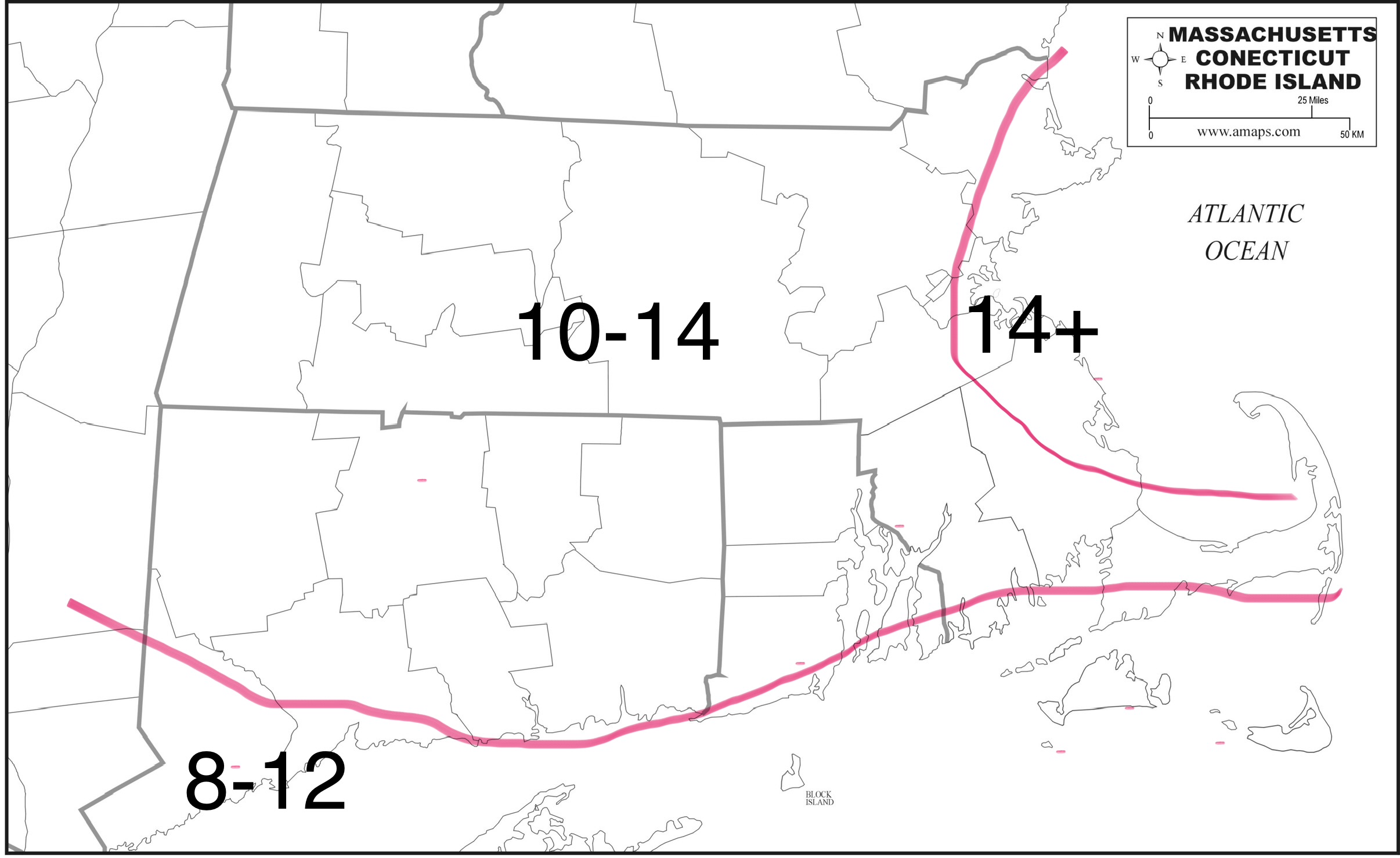
First call:
-
“Cory’s in LA! Let’s MECS!” Jan. 24-26 Disco
TauntonBlizzard2013 replied to TheSnowman's topic in New England
Definitely toned down though -
“Cory’s in LA! Let’s MECS!” Jan. 24-26 Disco
TauntonBlizzard2013 replied to TheSnowman's topic in New England
Tomorrow will be key in refining totals and seeing how real the coastal assist Monday is -
“Cory’s in LA! Let’s MECS!” Jan. 24-26 Disco
TauntonBlizzard2013 replied to TheSnowman's topic in New England
I’ll be issuing a first call map later, but general feeling is the floor in SNE east of ORH down into se Mass is like 12”. -
“Cory’s in LA! Let’s MECS!” Jan. 24-26 Disco
TauntonBlizzard2013 replied to TheSnowman's topic in New England
This screams like a Norwell/Hanover jack to me. Maybe even interior Cohasset and Marshfield, a couple miles away from the water. -
“Cory’s in LA! Let’s MECS!” Jan. 24-26 Disco
TauntonBlizzard2013 replied to TheSnowman's topic in New England
Who knows how it’ll play out. But 12z has been pretty consistent in this area. Generally 1.25.-1.50 -
“Cory’s in LA! Let’s MECS!” Jan. 24-26 Disco
TauntonBlizzard2013 replied to TheSnowman's topic in New England
Subtle trends to tick down qpf in most places, with the exception of eastern ma. -
“Cory’s in LA! Let’s MECS!” Jan. 24-26 Disco
TauntonBlizzard2013 replied to TheSnowman's topic in New England
Gfs is incredible here. 1.5” qpf all snow -
“Cory’s in LA! Let’s MECS!” Jan. 24-26 Disco
TauntonBlizzard2013 replied to TheSnowman's topic in New England
Weird Canadian run, seems like the true heavy stuff stays offshore. all relative of course, still prints out over an inch of qpf in eastern areas -
“Cory’s in LA! Let’s MECS!” Jan. 24-26 Disco
TauntonBlizzard2013 replied to TheSnowman's topic in New England
NAM is complete insanity here. Would easily be 18+ -
“Cory’s in LA! Let’s MECS!” Jan. 24-26 Disco
TauntonBlizzard2013 replied to TheSnowman's topic in New England
So what’s everyone’s guess? Snowday monday, do some places cancel Tuesday too? -
“Cory’s in LA! Let’s MECS!” Jan. 24-26 Disco
TauntonBlizzard2013 replied to TheSnowman's topic in New England
Decent overnight runs here -
“Cory’s in LA! Let’s MECS!” Jan. 24-26 Disco
TauntonBlizzard2013 replied to TheSnowman's topic in New England
Tick tick on the icon 1.5”+ in eastern ma -
“Cory’s in LA! Let’s MECS!” Jan. 24-26 Disco
TauntonBlizzard2013 replied to TheSnowman's topic in New England
Like 5 posts the last two hours. Storm fatigue setting in lol -
“Cory’s in LA! Let’s MECS!” Jan. 24-26 Disco
TauntonBlizzard2013 replied to TheSnowman's topic in New England
Euro making an attempt at those upper under totals, especially east. -
“Cory’s in LA! Let’s MECS!” Jan. 24-26 Disco
TauntonBlizzard2013 replied to TheSnowman's topic in New England
Icon looks great here. Printing out 1.25-1.50 liquid equivalent in eastern ma. even with marginally better than 10:1 ratios, that’s an 18” snowfall. -
“Cory’s in LA! Let’s MECS!” Jan. 24-26 Disco
TauntonBlizzard2013 replied to TheSnowman's topic in New England
Kind of a wild call at this lead. Very hard to walk that back if something changes lol -
“Cory’s in LA! Let’s MECS!” Jan. 24-26 Disco
TauntonBlizzard2013 replied to TheSnowman's topic in New England
Gfs sees a tad slower through 66. Wonder if that helps the final outcome