brettjrob
-
Posts
2,592 -
Joined
Content Type
Profiles
Blogs
Forums
American Weather
Media Demo
Store
Gallery
Everything posted by brettjrob
-
Central/Western Medium-Long Range Discussion
brettjrob replied to andyhb's topic in Central/Western States
As enthralling as these runs are, I despise seeing the H5 ridge axis running through IA-MN-ND. At this lead time, there's still enough uncertainty that the Tuesday trough could start pinching off and send everything into a tailspin, similar to the event this time in 2014. Not saying it will happen by any means. But the Andover comparisons are natural for many reasons, and I can't help but notice that the downstream ridge axis for that setup was through IN-MI. Will try to look at more analogs tomorrow. -
Central/Western Medium-Long Range Discussion
brettjrob replied to andyhb's topic in Central/Western States
I assume you're referring to Tue specifically, in which case I'll defer to your judgment, since I didn't get a chance to look at the hi-res ECMWF fields. The 4-5 day stretch on the GFS is just unreal for April, though (with Wed being the "down" day whose presence does little to change that fact, in reference to Chicago Storm's post). EDIT: 00z GGEM looks incredibly similar for the whole Tue-Fri period... my goodness. This is a pretty staggering suite of guidance tonight that's leaving me speechless. If the lead time were 72-144 hours, rather than 144-216, it would be hyperventilation time. -
Central/Western Medium-Long Range Discussion
brettjrob replied to andyhb's topic in Central/Western States
There's really nowhere to go but down from this GFS run for next week. The four-day stretch from Tue-Fri would probably rival a lot of great historical stretches in May/June, and be virtually unprecedented in April for the Plains in modern history. Emphasis on "nowhere to go but down." It's not a matter of whether we fall, but how far. -
Central/Western Medium-Long Range Discussion
brettjrob replied to andyhb's topic in Central/Western States
Encouraging signs in the medium range abound, but the timetable has shifted back almost as fast as real-time for the past 3-4 days. What was once an event centered on this Fri-Sat is now more like next Mon-Wed. To no one's surprise, significant eastern NA troughing in the polar jet late this week into the weekend is the fly in the ointment. When said troughing was progged to be weaker in the guidance a few days ago, this had some hallmarks of a high-end severe event. That's still a possibility, but I'm growing more skeptical, unfortunately. To be clear, with strong agreement regarding western CONUS troughing, I definitely expect a series of severe weather days between Sunday and the middle of next week. Just talking magnitude here. -
Thanks, guys! We definitely want to build a dedicated mobile site eventually, but it's likely still a ways off. Our priority has been adding features and making the main site as useful as possible thus far.
-
Central/Western Medium-Long Range Discussion
brettjrob replied to andyhb's topic in Central/Western States
It's hard not to feel sick, watching a trough reminiscent of 28 March 2007 amble into the Four Corners and probably lack in high-end severe potential. This blocky pattern is beyond maddening. On the other hand, the blockiness could ultimately be worth it if 2-4" of rain fall over much of the southern Plains over a 3-day period, which looks quite possible. Assuming a real pattern shift in our favor is somewhere up the pipeline, that could have a significant impact on future setups. I will say that I'm not too concerned about current progs beyond D+10 that look unpleasant. With meandering cutoff lows the rule over the next 7-10 days, predictability is simply piss poor. There's no denying that we've been kicked in the you-know-what yet again with an exceptionally awful start to the Plains season. Yet another year of hearing murmurs from veteran chasers about their latest first chase to-date -- the new normal, it seems. There's no upside to that at all, in my view. But at the same time, it's still early enough that if things turn around in the next 2-3 weeks and May/June are rockin', it won't matter very much. If we're still having this kind of discussion on April 30 with abysmal medium range progs, that will be a far different story. -
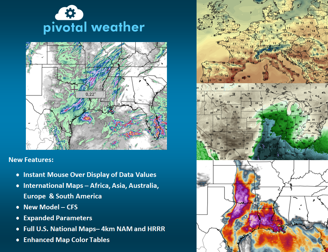
Update: March 28, 2016 We just launched our first significant upgrade over the weekend. Here are some of the new features: http://www.pivotalweather.com - Data readout as you hover over maps - International maps (covering each continent, plus some tighter zooms) - Addition of CFS model output - Expanded parameter list for most models - CONUS maps for HRRR and 4km NAM - Improved color tables Hope everyone enjoys, and as always, feel free to leave any comments or requests here!
-
Central/Western Medium-Long Range Discussion
brettjrob replied to andyhb's topic in Central/Western States
That's for damn sure. Was just commenting on this earlier. After 2013-2015, anything besides full-fledged winter east of the Rockies feels like a godsend. I'm not even worried about whether this upcoming system is a big severe weather producer - just moisture, rain, warmth, and a continued favorable pattern will suffice. Sunday or Monday may at least offer the customary first surface-based supercells on the Plains to kick the season off, as things stand. -
Central/Western Medium-Long Range Discussion
brettjrob replied to andyhb's topic in Central/Western States
Between the analogs and medium-long range guidance, it looks like potentially another season with southern stream disturbances undercutting broad ridging at higher latitudes (not exactly newsworthy coming out of a strong Nino). That happened a lot last year, too. 1987 and 2007 don't look all that different from each other in terms of mean springtime height anomalies, illustrating how relatively unpredictable details can make such a difference in the severe weather season. -
Central/Western Medium-Long Range Discussion
brettjrob replied to andyhb's topic in Central/Western States
Medium range guidance is optimistic about shifting to a mean western trough around next weekend into the following week. That should at the very least mean rain chances on the Plains and a lack of Gulf-wiping fronts, if not some severe weather opportunities. -
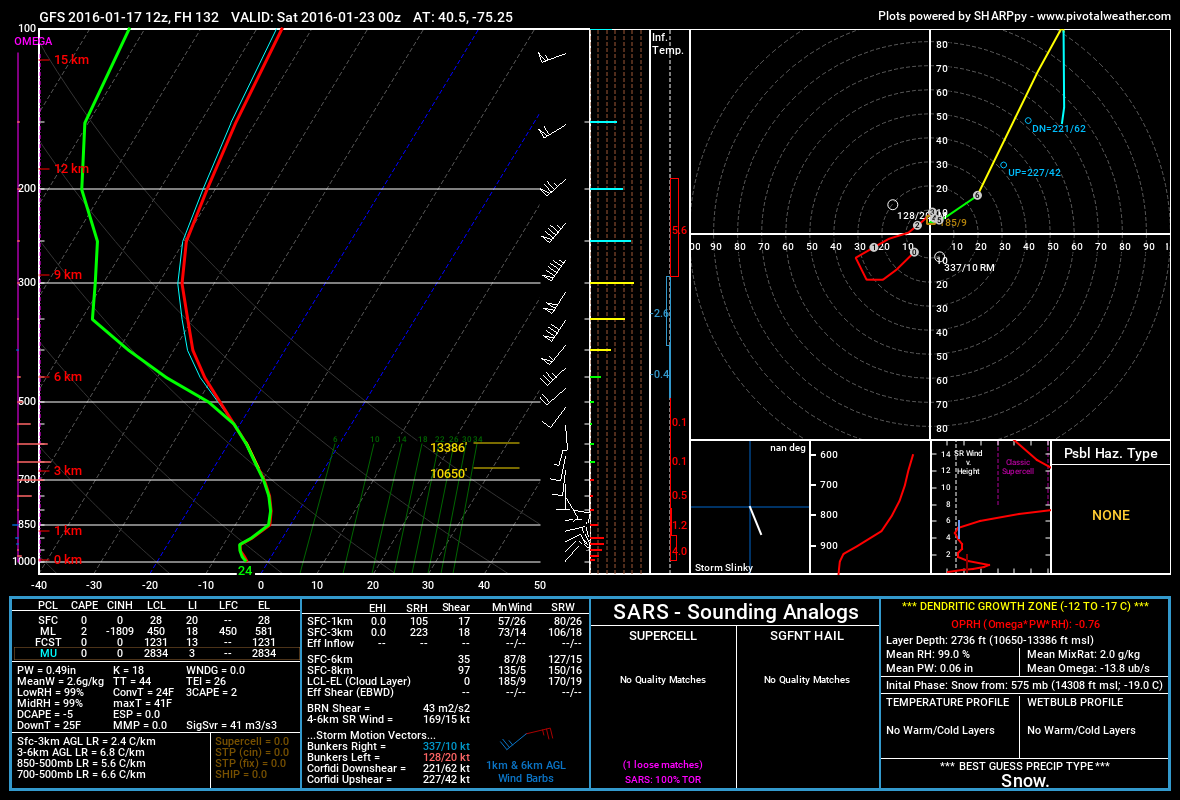
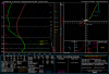
Thanks for the comments, guys, and sorry I took so long to check back in! We have noticed this issue with the 4km NAM accumulated snowfall graphics and are looking into a fix. Sorry about that! Thanks for your interest! We've heard this request a lot over the past couple months, so we're definitely looking into how feasible an app would be. If we ever make one, we want to be sure it truly adds value over simply using the site in a mobile browser. That's actually a somewhat tricky problem from a design standpoint, especially on phones with smaller screens. If we continue to grow and do well this year, then perhaps by next winter an app will be in the cards! The omega profile is located on the far left of the Skew-T panel. Keep in mind that it only appears for winter weather soundings. When you create a sounding, our code determines whether it should be created in "winter weather" or "severe weather" mode based on the temperature profile. If it's cold enough to support frozen/freezing precip, then the "winter weather" mode will be used, and the omega profile is shown. I've circled the omega profile in yellow, and the winter precip information panel (bottom right) in red on this example from CO today. The dendritic growth zone is also highlighted as a yellow segment along the temperature line (red) of the Skew-T for winter soundings.
-
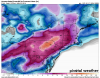
For those who haven't seen it yet, I just wanted to make you aware of a new model site that some friends and I started up back in November: http://www.pivotalweather.com We are currently free and supported by ads (please disable any ad blockers, if possible!). We strive to provide premium graphics comparable to existing pay sites, and we think we're doing a good job of that so far, though we certainly have plans to expand further in the coming months. A few key features which may be of interest to the winter crowd here: - Snowfall accumulation at 6-, 12-, and 24-hour intervals (along with run total accumulation to-hour) for the GGEM, GFS, NAM, 4km NAM, RAP, and HRRR - Point values plotted at METAR locations for many surface maps, including snowfall - Both Kuchera and 10:1 ratio snowfall accumulation maps - Clickable soundings for all 5 NCEP models we have (GFS, NAM, 4km NAM, HRRR, RAP), including a highlighted dendritic growth zone, omega profile, and more Attached are a couple sample images showing off the potential major winter storm this coming week. Enjoy, and let us know if you have any comments or suggestions!
-
Central/Western Medium-Long Range Discussion
brettjrob replied to andyhb's topic in Central/Western States
Trend over the past 24 h since your post has been toward focusing the most interesting period on Monday over OK/TX, before the system becomes more barotropic thereafter. Right now it looks a bit too positive-tilt to get me excited about the hodo shape (particularly given that instability is likely to be seasonably modest), but it's nice to see the above-average November severe activity continue. http://www.pivotalweather.com/model.php?m=GFS&p=03ehi&rh=2015111212&fh=108&r=sc&lat=33.5000&lon=-98.3780&metar= ECMWF looks relatively similar this afternoon, with 1000 J/kg SBCAPE nosing into SW OK by Monday afternoon. -
Central/Western Medium-Long Range Discussion
brettjrob replied to andyhb's topic in Central/Western States
The next 7-10 days aren't looking too promising, at least anywhere in the Plains. The fat lady may have been warming up as the June 4-6 sequence concluded and we didn't even know it at the time. After an exceptionally active April-May pattern wise, it's not too surprising. That said, it is still June, and there will still be tornadoes on various days. And "real" setups can't be ruled out north of I-80 even heading into late June and July. -
Central/Western Medium-Long Range Discussion
brettjrob replied to andyhb's topic in Central/Western States
If only that upper low progged to sit over CA late next week into the weekend were shifted 300-400 mi. E, we'd complete our 1995 analog with style. -
Central/Western Medium-Long Range Discussion
brettjrob replied to andyhb's topic in Central/Western States
Been watching the period next week on the Euro for several runs, and I'm concerned that it's consistently depicted most of the upper flow north of the front. There should be at least a half-state area of 25+ kt H5 flow over the warm sector for several days, hopefully. -
Central/Western Medium-Long Range Discussion
brettjrob replied to andyhb's topic in Central/Western States
Agreed -- we'll just have to see whether we can manage 35-40 kt of bulk shear over good instability to determine whether those nickel-and-dime events are fruitful. Really, almost every Plains event this entire spring so far has been nickel-and-dime in terms of results, though, despite so many promising longwave troughs. So results-wise, this may not be that much of a dropoff. -
Central/Western Medium-Long Range Discussion
brettjrob replied to andyhb's topic in Central/Western States
Recent operational runs are a bit concerning heading into early-mid next week, but it's a period of low predictability per ensembles. I'd be fine with some downtime next week for a pattern "reset," hopefully featuring a period of drying for the Chihuahuan and Sonoran deserts and reduced STJ influence. Plus, so far this season since late March, a broadly favorable pattern has found a way to reassert itself quickly during every period of doubt. With the amazing ET this year, all we need is one or two decent (even subtle) troughs the rest of the spring without the overwhelming STJ influence, and periods comparable to late-season 2004 or 2010 should be easily within reach. It will be a crying shame if the grungefest setups continue unabated through May and June, but still better than some recent years. -
Central/Western Medium-Long Range Discussion
brettjrob replied to andyhb's topic in Central/Western States
Looking at the ECMWF and its ensembles, and considering what's already in the books and about to occur this week, this will easily rank up there with 2008 and 2010 as among the most active May months on the Plains over the past decade. It could easily surpass those, too, since neither had much of anything during the first 10 days. (Speaking of which, since around April 10, there's been no extended downtime lasting more than 5-7 days really... it's been a long while since that's happened, too). Unfortunately, I'm speaking in terms of the broad continental pattern, rather than the results. Last week was something akin to having a 980 mb low pass just SE of Cape Cod in January and Boston only picking up 3-4". "Oh well, there'll be more" -- except we'd been waiting years to see a trough like that in May or June, especially without extreme PBL mixing over the High Plains. We'll see about this Fri-Sat. Even as it stands, and assuming this week falls short of its potential, the "results" for May should be better than all but 2013 out of the past four years. Still, you can go quite a few years without an optimally-timed pattern like this, and it would be nice to cash in finally... -
Central/Western Medium-Long Range Discussion
brettjrob replied to andyhb's topic in Central/Western States
Major morning convection on the 00z GFS for both Fri and Sat, and the STJ is still carving across N Mexico into TX. I'm certainly taking model QPF at face value this time and assuming an outcome substantially less than the ceiling suggested by H5, rather than falling for the "holy crap, that trough in mid-May without drought concerns can do no wrong" voodoo I did last week. This is the second trough in a row that looks like a borderline-inevitable outbreak at this time of year, and better than most anything we've seen late season since 2010-2011... but this is no ordinary season. Now, obviously, there will still be some tornadoes (at least Saturday), just as there were every day last week. -
Central/Western Medium-Long Range Discussion
brettjrob replied to andyhb's topic in Central/Western States
If you take the H5 evolution from the 00z GFS literally, there's no way that doesn't get the job done kicking out over mid-upper 60s dews in mid-May, no matter the timing or prior convective evolution. "Bad" timing could hurt chaseability and/or prevent it from being an outbreak, but there'd still be at least a few tubes in the area centered on SW KS, methinks. At this point, the only thing that would make me think Saturday won't be noteworthy is a wholesale change in the trough evolution. -
Central/Western Medium-Long Range Discussion
brettjrob replied to andyhb's topic in Central/Western States
The Euro wants to make this an issue virtually every day this week, with at least one convective QPF bomb somewhere along the dryline by 18z. Aside from that, I'm becoming very optimistic about this four-day stretch from Wed-Sat. There isn't a day in there that doesn't feature realistic potential for classic tornadic sups across the Panhandles, W OK, and SW KS. Wednesday could be big, and Saturday almost certainly would find a way to be big even if it fires early, unless the synoptics change substantially from the current Euro depiction. The fact that several setups in April were wrecked by morning convection makes me nervous, but we'll see. It's May, and I doubt that can be a dealbreaker four days in a row. -
Central/Western Medium-Long Range Discussion
brettjrob replied to andyhb's topic in Central/Western States
Yeah, May 1991 easily blows anything we've seen since May 2010 out of the water, at least for my tastes (I know 2013 has an argument, if you ignore the I-35/OKC magnet aspect). Between 5/10, 5/16, and 5/26, it would be hard to ask for a lot more -- and there were a lot of other localized tornado days across the Panhandles and W KS. -
Central/Western Medium-Long Range Discussion
brettjrob replied to andyhb's topic in Central/Western States
Agreed with all of this. Next week reminds me some of the first week in June last year. We finally had decent moisture and instability after an abysmal mid-late May, but upper flow was lacking. Still, it was the kind of pattern that can sometimes lead to a string of localized but impressive tornado events (ala late May 2010 or late May 2013)... or sometimes lead to virtually nothing except lots of wasteful chasing (ala early June 2014). Now, because ET (evapotranspiration) should be at least somewhat better than we saw at any point last spring south of I-70, I think the odds of at least one day coming through are decent. But for chasers, it will require a lot of miles, skill, and luck to be there if something in the vein of Bennington 5/28/13 or Texline 5/23/10 pops up at the last minute. These are obviously speculative and preliminary thoughts, though. After all, the ECMWF went from showing a crashing cold front late next week on last night's run to a decent Four Corners closed low around the same time this afternoon. Oh, and that tropical low sitting off the Carolina coast next week dragging crappy air into the eastern Gulf can GTFO. -
Central/Western Medium-Long Range Discussion
brettjrob replied to andyhb's topic in Central/Western States
I can't be the only one getting concerned about the "jet disappearing into Canada act" (ala May 2009/2012) that seems to be a theme on MR guidance. There may be several days of semi-interesting high CAPE/low shear potential next week, and there's always a chance one of those days could emerge as more significant. But if we're talking amplified western CONUS troughing and large-scale organized threats, it seems we might be waiting until closer to mid-month, at least.