

Paulie21
-
Posts
64 -
Joined
-
Last visited
Content Type
Profiles
Blogs
Forums
American Weather
Media Demo
Store
Gallery
Everything posted by Paulie21
-
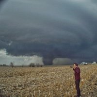
It's got that look honestly.
-
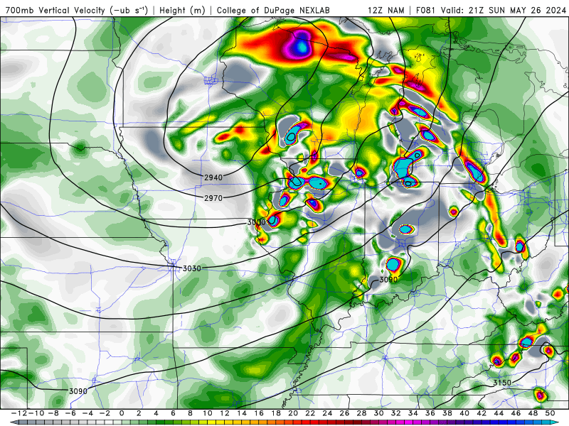
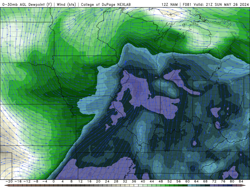
2024 Short/Medium Range Severe Weather Discussion
Paulie21 replied to Chicago Storm's topic in Lakes/Ohio Valley
End of NAM hype but Sunday is looking more and more interesting. Has already looked pretty solid on globals the last couple of days too.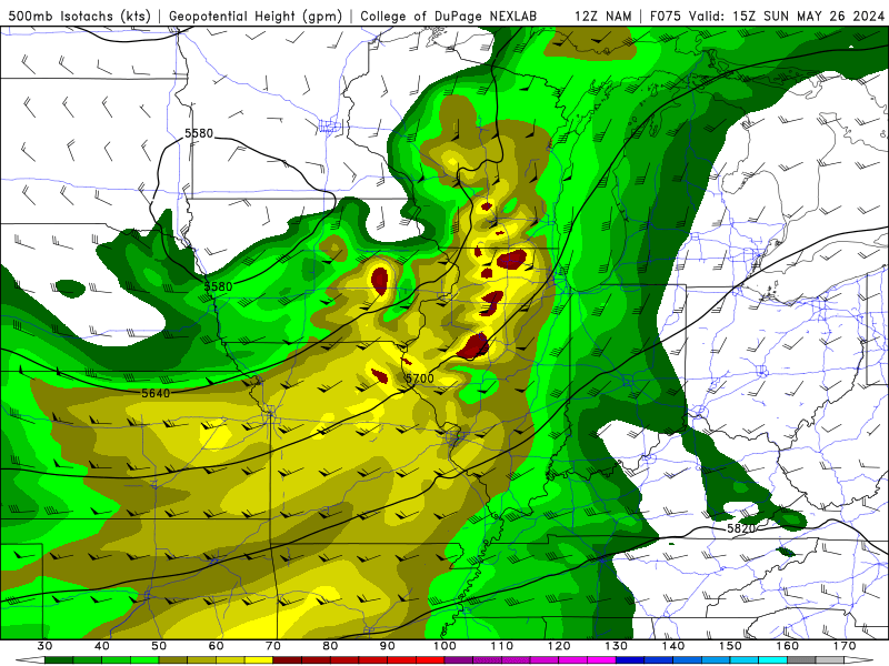
-
Did Someone Say Clipper(Hybrid)!?! 1/18-1/19
Paulie21 replied to Frog Town's topic in Lakes/Ohio Valley
Yeah the LE looks almost textbook. Crazy long fetch with steady 600+ lake induced CAPE for hours. Could definitely see 3"+/hr rates in that at times. -
Sitting just shy of 6" in West Dundee. Had some pingers mixing in for a couple hours, back to all snow. Flakes slowly improving here
-
Yeah NIU coop obs at 7am got 6.0 with 0.61 liquid equivalent.
-
Weenie band in full force on the NAM.
-
Fun morning commute brought to you by the new RAP
-
There's a good consensus on the morning stuff really ripping across NE IL at ~12Z Very strong lift nearly maxing out in the shallow DGZ and then some. Steep lapse rates above 700mb with a hint of some frontogenetic banding. Truly cannot rule out some TSSN in this weenie band. Gonna be snow globing right in time for morning commute. Edit: Also, just looked at bufkit, some near 0 EPV in a large portion of this column for a couple hours.
-
Good snippet from Gino regarding these aggregates: "the recipe for the HUGE aggregates like that is deep ascent throughout the column, through a wide temp range to get a variety of flake types and then the key is a deep isothermal layer near or just below 0C where the snow is wet and prone to clumping. This is about as perfect of a set-up for that as you'll see"
-
Yeah these ratios are definitely a buzzkill. DGZ is rather shallow and most of the time the omega is nothing to write home about either. Here's 12Z HRRR for KDPA. Wouldn't be surprised if front end WAA thump over performs a bit, but overall liking midday Tuesday for NW/W burbs. Liking my chances here in West Dundee. Although UVV's aren't a bullseye, it's much more promising the prior hours. Additionally, liking the theta-e during that time too for some weak symmetric stability, although the lack of fgen banding might inhibit the potential. Either way, it wants to puke out over an inch of concrete in an hour during lunch time.
-
Another promising GFS run on the 12Z, slight bump north, wetter, bit of a stronger low. A bit far out still but nice to see favorable UVV's increase from previous runs.
-
i lol'd
-
FWIW the 21Z RAP is basically just last Friday lol. Stronger LLJ remains in W IL but the sfc flow is far better in E IA. Gonna be another split between everyone sitting in Galesburg vs Iowa City. Pick your poison.
-
12Z GFS is a widespread outbreak type run. Been a while since I've seen anything like it. Perfect H5 Jet ejection, LLJ cranking across the entire warm sector with widespread 2500+ SBCAPE. Nuts.
- 499 replies
-
- 11
-

-

-
Jan 24-26th Potential Something Part 2
Paulie21 replied to Chicago Storm's topic in Lakes/Ohio Valley
Not sure if this was mentioned but... "All six weather balloon launch sites along the West Coast and northwest Mexico did not report data this morning, for various reasons. Thus, the major system that is going to affect the Midwest and Great Lakes on Sunday night into Tuesday has limited data for forecasters and models to work with. Ugh. Use all morning and afternoon models with even more caution." From Gilbert Sebenste -
The HRRR and current radar are a bit too different to compare at this moment.
-
Upstate/Eastern New York
Paulie21 replied to BuffaloWeather's topic in Upstate New York/Pennsylvania
Thank you. Just glancing at the sounding, the blue box on the left I circled implies strength of upward vertical velocities. This is a rather strong signature and almost a textbook case because it is essentially in the same layer as the DGZ. DGZ is the dendritic growth zone, an thermal area between -12 to -18 C (highlights on the skew-T here with red dashed lines I made). Soundings highlight any saturated (has to be saturated) column with yellow on the temperatures line. The DGZ will help produce larger flakes and the lift will help flakes stay in that layer and make larger aggregates as they eventually fall. The reason for this strong signatures of upward vertical velocities is due to jet coupling enhancing lift (left exit region of trough and right entrance region of jet to the north), as well as frontogenesis aloft. 850mb is somewhat weak in this scenario. Looks better ~700mb.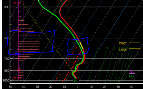
-
Upstate/Eastern New York
Paulie21 replied to BuffaloWeather's topic in Upstate New York/Pennsylvania
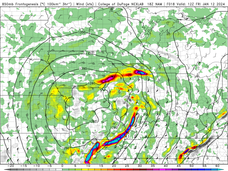
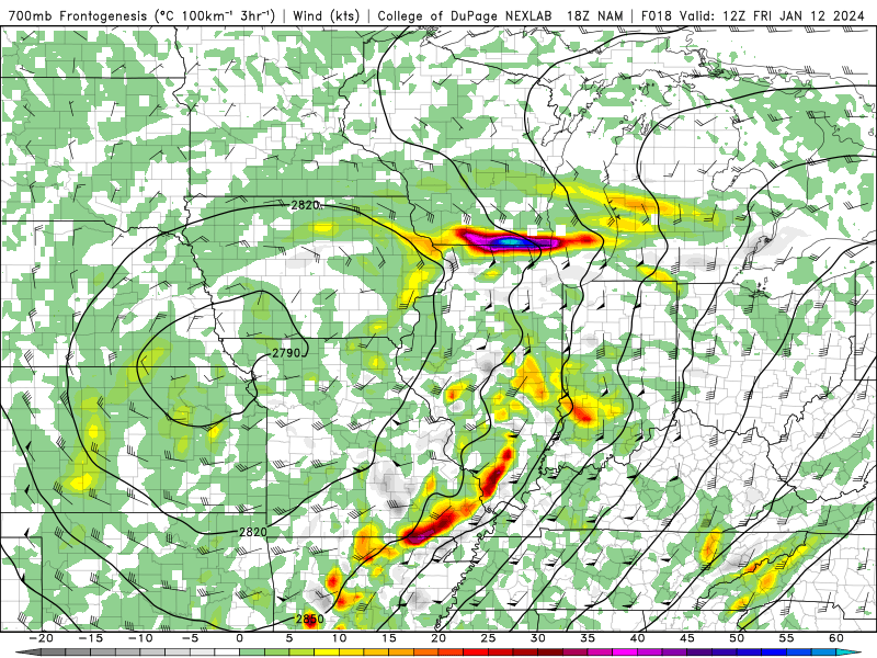
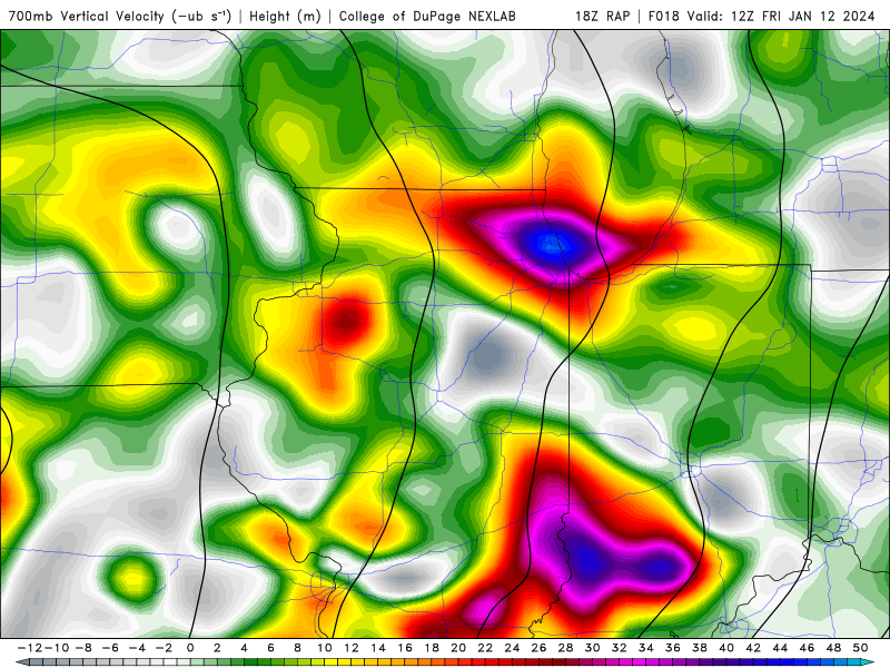
The jet coupling on the 18Z NAM looks like a hot spot for upstate NY. All the way from KROC to Watertown. Ridiculous omega values on the sounding basically perfectly co-located the the DGZ (shallow but still a good sounding). This looks like fat dendrites are gonna be falling during an awful commute Friday morning and then some... All this thanks to being right between the left exit region of the trough and right entrance of the jet to the north. This, coupled with a juiced deformation band with ton of stretching and frontogenesis..sounds like it'll be ripping.
-
Central/Western Medium-Long Range Discussion
Paulie21 replied to andyhb's topic in Central/Western States
I feel like I have said this next sentence several times this year already but...ensembles don't look bad for next weekend, along with the OP GFS. ECMWF solid as well for now. All agree on some flow aloft in the plains. As everything in June and rest of the season goes, thermodynamics shouldn't be an issue, all kinematics from this point on.. At least something to look at and hopefully not disappoint like everything else has when it disappeared before it even got into the NAM range. -
Central/Western Medium-Long Range Discussion
Paulie21 replied to andyhb's topic in Central/Western States
ERTAF continues to predict "Above Average" tornado activity for the period of 4/17 to 4/23 despite the progged barotropic nature of the upper levels. AAM begins going negative and in the favorable zone for western troughing. Chiclets look pretty variable during this time becoming more active going into May...FWIW of course, since the CFS becomes worse than climo beyond 18 days..

