

schoeppeya
-
Posts
558 -
Joined
-
Last visited
Content Type
Profiles
Blogs
Forums
American Weather
Media Demo
Store
Gallery
Everything posted by schoeppeya
-
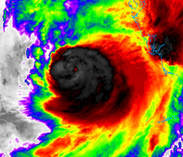
I am impressed with how the eye has centered itself within the convection given the shear
-
Agreed. At least to this point, the degraded IR presentation looks to be more from an ERWC than from shear blasting the core. As others have pointed out, the models that degrade the storm rapidly basically dissipate the southern half of the storm due to dry air and looking at lower level water vapor imagery im just not seeing the dry air to the south of the storm for shear to push in yet. I also don’t see how this doesn’t make landfall significantly earlier than it looked last night
-
What exactly are the decreasing threats? This is still a 155 mph cat 4 that is right on track with intensity expectations and encountering shear as has been widely discussed for 48 hours. It may well end up weaker then expected but high end impacts are baked in at this point
-
Those supercells that are offshore are going to be a really, really bad situation.
-
Eye coming into view on the key west radar
-
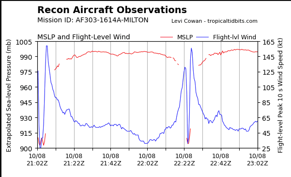
I don’t know how much to value it but just for trend it’s basically steady state on intensity between now and landfall
-
Yeah have to think the next 10-12 hours are the best remaining window of higher water temps and lowish shear. Should be solidly over the loop current now
-
Does like maybe the beginnings of a new outer eyewall/secondary wind max as well?
-
Literally rides the northern side of Tampa Bay as well
-
18z HAFS B initialized about 35 mb too high
-
Don't be sorry, I am wrong all the time! ETA: I measured and youre right its pretty stable in size right now
-
The eye is really contracting again... I wonder if we will see another EWRC and intensification phase while conditions are still very favorable tonight into tomorrow morning
-
Almost perfect IR presentation again. I don't think we will get there but just given the overall look I wouldn't be shocked if we make a run at yesterdays numbers.
-
HAFS-B still wants to ride the north side of the bay but the hurricane models are becoming outliers on that at this point
-
Wow that IR presentation escalated quickly
-
I dont know if they missed it as much as the center was in between data readings because the eye is so small... waiting for that dropsonde
-
No signs of an ERC yet
-
They should be basically through a pass, last update on TT is from almost half an hour ago and they were just outside the CDO
-
Going to be a biblical run, eye still condensing and cloud tops still cooling
-
The stuff these hurricane hunters do inside storms makes me feel like an absolute fool for any type of flight anxiety I have.
-
Eye really clearing on IR, pressure likely going to continue to crater.
-
Considering we are on the cusp of 5 already I think that's almost a lock at this point
-
HWRF continues to show worse case scenario for TB. Actually re-deepens in a few mb before landfall.
-
10mb drop in between passes?!
-
Looks like a steadily/rapidly intensifying hurricane to me.


