Dan76
-
Posts
2,590 -
Joined
-
Last visited
Content Type
Profiles
Blogs
Forums
American Weather
Media Demo
Store
Gallery
Everything posted by Dan76
-
Gets to 939 Lol
-
Mid Atl ?
-

-
-
Merry Christmas everyone.
-
-
George?
-
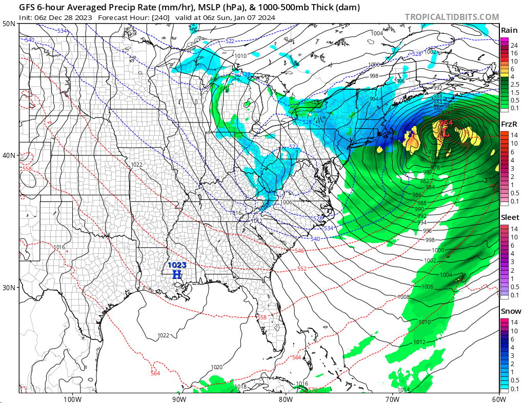
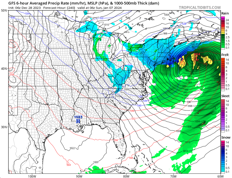
Sunday, December 17 - Monday, December 18, 2023 Storm
Dan76 replied to weatherwiz's topic in New England
https://www.sundayriver.com/ Op's suspended for tomorrow and i'm sure longer. Right before xmas ughh. -
Moderate-High Impact Storm Noon Sun Dec 17, 2023 - 4PM Mon Dec 18. Flooding rain I95 corridor northwestward, coastal tidal flooding, brief periods of damaging 50 MPH+ wind gusts LI/CT Monday, ends as a little wet snow interior elevations Tue morning.
Dan76 replied to wdrag's topic in New York City Metro
Freeport is flooded pretty good now.- 489 replies
-
- 1
-

-
- flooding rains
- coastal flooding
- (and 4 more)
-
Moderate-High Impact Storm Noon Sun Dec 17, 2023 - 4PM Mon Dec 18. Flooding rain I95 corridor northwestward, coastal tidal flooding, brief periods of damaging 50 MPH+ wind gusts LI/CT Monday, ends as a little wet snow interior elevations Tue morning.
Dan76 replied to wdrag's topic in New York City Metro
Some serious waves while watching it live .- 489 replies
-
- 1
-
-
- flooding rains
- coastal flooding
- (and 4 more)
-
Moderate-High Impact Storm Noon Sun Dec 17, 2023 - 4PM Mon Dec 18. Flooding rain I95 corridor northwestward, coastal tidal flooding, brief periods of damaging 50 MPH+ wind gusts LI/CT Monday, ends as a little wet snow interior elevations Tue morning.
Dan76 replied to wdrag's topic in New York City Metro
Puffing pretty good in SC https://www.ndbc.noaa.gov/station_page.php?station=41004 -
This is weird. Hazardous Weather Outlook National Weather Service Mount Holly NJ 1045 AM EST Wed Dec 13 2023 ANZ450-141545- Coastal waters from Sandy Hook to Manasquan Inlet NJ out 20 nm- 1045 AM EST Wed Dec 13 2023 This Hazardous Weather Outlook is for the Atlantic coastal waters adjacent to Monmouth County out 20 nm. .DAY ONE...Through tonight. There is a low probability of widespread hazardous weather. .DAYS TWO THROUGH SEVEN...Thursday through Tuesday. Gale-force winds and/or very rough seas are forecast on Sunday. Hurricane-force winds and/or dangerously high seas are expected on Monday. Storm-force winds and/or very high seas are expected on Tuesday.
-
NYZ075-078>081-176>179-091000- /O.NEW.KOKX.HW.A.0001.231210T2100Z-231211T1100Z/ Kings (Brooklyn)-Northwest Suffolk-Northeast Suffolk- Southwest Suffolk-Southeast Suffolk-Northern Queens- Northern Nassau-Southern Queens-Southern Nassau- 333 PM EST Fri Dec 8 2023 ...HIGH WIND WATCH IN EFFECT FROM SUNDAY AFTERNOON THROUGH LATE SUNDAY NIGHT...
-
Still High wind watch for Nassau unless they updated it.
-
Same batch that delayed steelers game ?
-
Deja vu all over again.
-
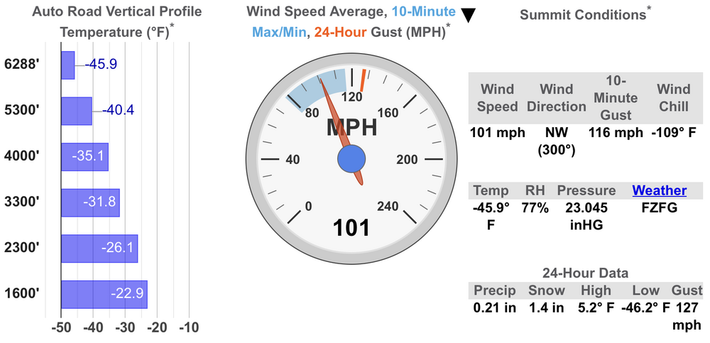
LOL This Afternoon Snow. The snow could be heavy at times. High near 11. Wind chill values between -15 and -22. Windy, with a west northwest wind 29 to 34 mph, with gusts as high as 60 mph. Chance of precipitation is 80%. Total daytime snow accumulation of 32 to 38 inches possible. Tonight Snow. The snow could be heavy at times. Temperature rising to around 12 by 11pm. Wind chill values between -11 and -17. Windy, with a southwest wind 24 to 34 mph increasing to 39 to 49 mph in the evening. Winds could gust as high as 70 mph. Chance of precipitation is 100%. New snow accumulation of 44 to 50 inches possible. Saturday Snow. The snow could be heavy at times. Steady temperature around 10. Wind chill values between -9 and -18. Windy, with a west wind 44 to 49 mph decreasing to 36 to 41 mph in the afternoon. Winds could gust as high as 70 mph. Chance of precipitation is 100%. New snow accumulation of 20 to 26 inches possible. Saturday Night Snow. The snow could be heavy at times. Low around 12. Wind chill values between -8 and 2. West southwest wind 17 to 20 mph, with gusts as high as 25 mph. Chance of precipitation is 100%. New snow accumulation of 17 to 23 inches possible. Sunday Snow. The snow could be heavy at times. High near 21. Windy, with a southwest wind 20 to 30 mph increasing to 30 to 40 mph in the afternoon. Winds could gust as high as 55 mph. Chance of precipitation is 100%. New snow accumulation of 23 to 29 inches possible. Sunday Night Snow. The snow could be heavy at times. Low around 16. Chance of precipitation is 90%. New snow accumulation of 16 to 22 inches possible.
-
Is it really asking too much for something like that?
-
58 https://www.wunderground.com/dashboard/pws/KNYWANTA21
-
The best are the ones who walk down stairs backwards in boots lol
-
After i guess
-
The solution is so simple... Stop making people,but we know that will never happen.
-
And then there's this.