

Ellinwood
-
Posts
6,191 -
Joined
-
Last visited
Content Type
Profiles
Blogs
Forums
American Weather
Media Demo
Store
Gallery
Everything posted by Ellinwood
-
Pre-dawn start and cold low-levels will help, but that warm nose is gonna be a bitch.
- 352 replies
-
- 19
-

-

-
I'm pessimistic southeast of I-95. Rain or rain/snow mix early and temps struggling to reach freezing there. Hopefully rates can overcome it.
-

Jan 31st - 33rd Storm Obs and Disco like it's 1979
Ellinwood replied to Bob Chill's topic in Mid Atlantic
Nothing too crazy. I think the NWS has a pretty good grasp of things right now. I'm relying mostly on the Sunday front-end thump along+east of I-95.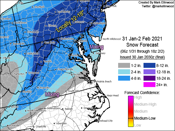
-
I'm too fast for ya!
-
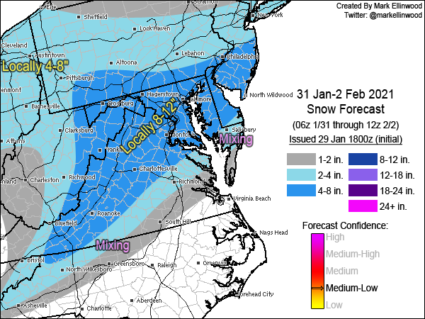
Snow map. Very complicated setup with lots of caveats, but we seem to be converging on a moderate to major snow event across the Mid-Atlantic. IMO major decider will be coastal low development and resulting QPF for Monday.
-
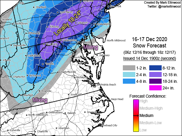
December 16-17, 2020 Winter Storm Obs/Nowcasting
Ellinwood replied to WxUSAF's topic in Mid Atlantic
Final... I hate how much sleet is progged to get northwest of I-95, but IMBY in Germantown I would think 3-5" of snow/sleet with downside 2" upside 6-7" is a good forecast. -
No changes... gradient area near I-95 is boom or bust at this point. Leaning slightly toward bust near I-95, but this isn't worth micro-editing.
-
"I am altering the gradient. Pray I don't alter it any further." It was difficult because I also lowered my IMBY 6-8" forecast to 4-6", and I was contending with pulling the higher amounts even a tick further north than that. 12z EPS saved it for now, hehe.
-
Eh. I was too high on amounts regionally for all but like 2 events a couple of years ago, lol.
-
Updated my snow map... cut down on the total on the eastern gradient (mainly DC up I-95 and through southern and central NJ). Increased totals along the Appalachians.
-
Haha you're fast. Initial thoughts... It's like 70% Euro 30% GFS. Respecting the Fall Line locally.
-
Let the Fall Line do Fall Line things. Don't overthink it.
-
Wednesday looks pretty legit... people are still suffering from 2019-20 PTSD.
-
Been looking at places along/near I-81 for buying a house next year, but not being familiar with the housing market in these areas, I'm looking for advice on good up-and-coming or established areas. Looking mainly at the Hagerstown area and near the I-81/I-66 interchange anywhere between Winchester and Strasburg/Front Royal. Wife wants access to the western side of the DC beltway, so NoVA is more of a priority.
-
I was pinged last week Y'all need some fresh emojis. I should start posting again. Missed all of y'all that aren't regular Twitter peeps.
-
RIP
-
Easy come, easy go.
-
Central/Western Medium-Long Range Discussion
Ellinwood replied to andyhb's topic in Central/Western States
If there's one thing that Ian hates, it's waiting. -
I like this year better.
-
Mid-Atlantic Snow forecast For March 24-25 (Final)
Ellinwood posted a blog entry in Ellinwood's Weather Blog
Same general theme, with a slight shift south along the southern edges and a more pronounced southern shift towards the upper part of the map. Risks are generally to the higher side on the southern fringe areas if the models are to be believed (especially if the overnight front-end thump is fairly wet). -
Mid-Atlantic Snow forecast For March 24-25 (Initial)
Ellinwood posted a blog entry in Ellinwood's Weather Blog
The DC-Baltimore-Philly areas are expected to miss out on the more significant accumulations yet again as bothersome low-level temperatures above freezing and March climo. rear their ugly heads. One of the saving graces with this event is the onset of snow will be overnight, though this did not really help the I-95 corridor and points east during the last event back in the first week of March. Surface temperatures will generally be above freezing in the lower elevations, so these areas will need good rates to make up for it. A large chunk of the precipitation is expected during the daytime hours, where we will have the March Sun to contend with in addition to the temperatures. Higher elevations that stay at or below freezing will fare much better with accumulation. Forecast confidence is normal to slightly below normal. -
Mid-Atlantic Snow forecast For March 5-7 (Final)
Ellinwood posted a blog entry in Ellinwood's Weather Blog
There were some detail changes due to adjustments in the storm track, which mostly affected central/northern PA, southern VA and the Delmarva Peninsula. Higher confidence in the higher snow totals brought some upscale changes to northern VA. It's still a low confidence forecast overall, with both upside and downside risks across most of the impacted region. -
Mid-Atlantic Snow forecast For March 5-7 (Initial)
Ellinwood posted a blog entry in Ellinwood's Weather Blog
So here we are with another complicated setup and poor model agreement leading to a low confidence forecast. The good news is it looks like DC is finally going to get a decent storm! It only took until March... Anyway, right now it looks like the biggest risks are along the coast and in PA and southern VA. I'll save some of the more intricate details for the final forecast, but there is going to be some serious issues with the rain/snow line in the lower-total areas to the south, with precip. shield concerns across PA, NJ and southern NY. There is also some upside risk west and a little north of DC, where strong banding will likely occur somewhere in there. The other big question is with the coastal low track and whether or not the more northerly GFS and bring higher snow totals to PA/NJ northward or if the more conservative Euro wins out in those areas. In that case, I decided to lean a bit more towards the Euro with the lower totals. Some strong, gusty winds are possible east of the mountains north of the VA/NC border. EDIT: Somehow an old forecast got uploaded. Fixed now. -
Mid-Atlantic Snow forecast For February 13 (Only/Final)
Ellinwood commented on Ellinwood's blog entry in Ellinwood's Weather Blog
Morning update: I would cut back on the totals in MD, northern VA and central PA for now... not liking the trends that I'm seeing.


