Winter Wizard
-
Posts
642 -
Joined
-
Last visited
Content Type
Profiles
Blogs
Forums
American Weather
Media Demo
Store
Gallery
Everything posted by Winter Wizard
-
35/25 in Annapolis. Going to be a close call for getting flakes here.
-
Light snow/sleet mix in Annapolis. Had a decent glaze of ice on hard surfaces this morning.
-
I'm a bit farther west than you. Sleet bomb continues here. Measurements in the grass range from 1.2-1.8" or so.
-
And now we're back to sleet but that was probably the heaviest snow we've seen all year.
-
Wow, just flipped to mostly snow in Annapolis!
-
Got about an inch of sleet on the ground and still assaulting at the moment. It's brutal outside. Can't even be mad about missing out on the snow, this is a unique event and it's better than freezing rain.
-
Wow, heaviest and loudest sleet I've experienced in years.
-
Light sleet in Annapolis, been that way since the very beginning.
-
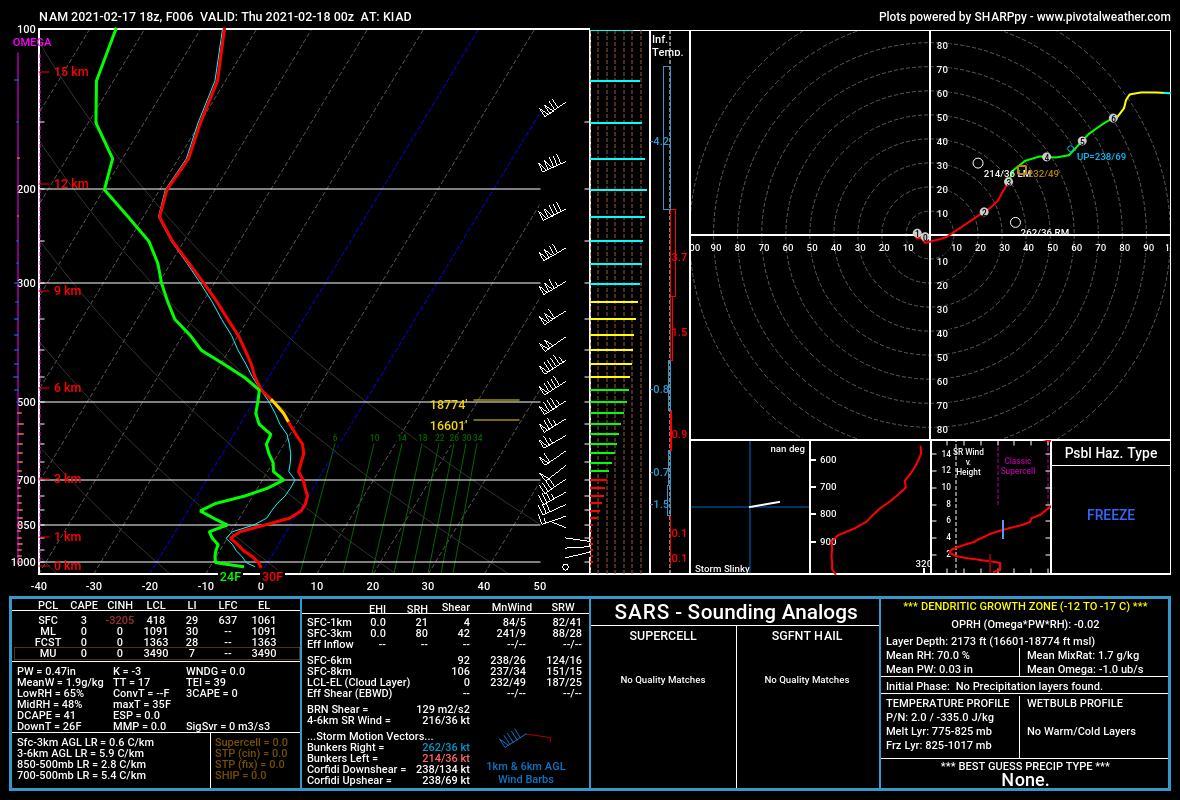
Biggest takeaway from that is the mid-levels are about a degree warmer which is not a good sign. Being drier does mean more radiation cooling so while it’s not a bad thing, doesn’t mean much if the 850s torch.
-
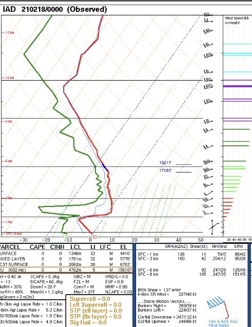
Here is a side by side comparison of the observed 0z sounding at Dulles vs. the 18z NAM depiction.

-
I'll throw my hat in the ring this time. I like 1-3/2-4" for DC before the changeover, a little more in Baltimore with amounts steadily increasing to the north and west. More concerned about the potential for prolonged icing along and east of I-95.
- 352 replies
-
- 17
-

-

-

-
Looks like 18+ straight hours of ice near I-95 on top of a few quick inches of snow. If that verifies, yikes.
-
Yes, the issue with this storm is almost entirely in the mid-levels. Surface track does matter to an extent, and it is favorable for us, but the upper-level low tracks right over us - you want it to be south and east. Trough axis as a whole is too far west. We end up getting stronger warm air advection at the 700-850 mb level and that's what changes the cities over to sleet and freezing rain. The stronger warm air advection is also what's helping create lift and why you're seeing the intense FGEN bands depicted on the front end.
-
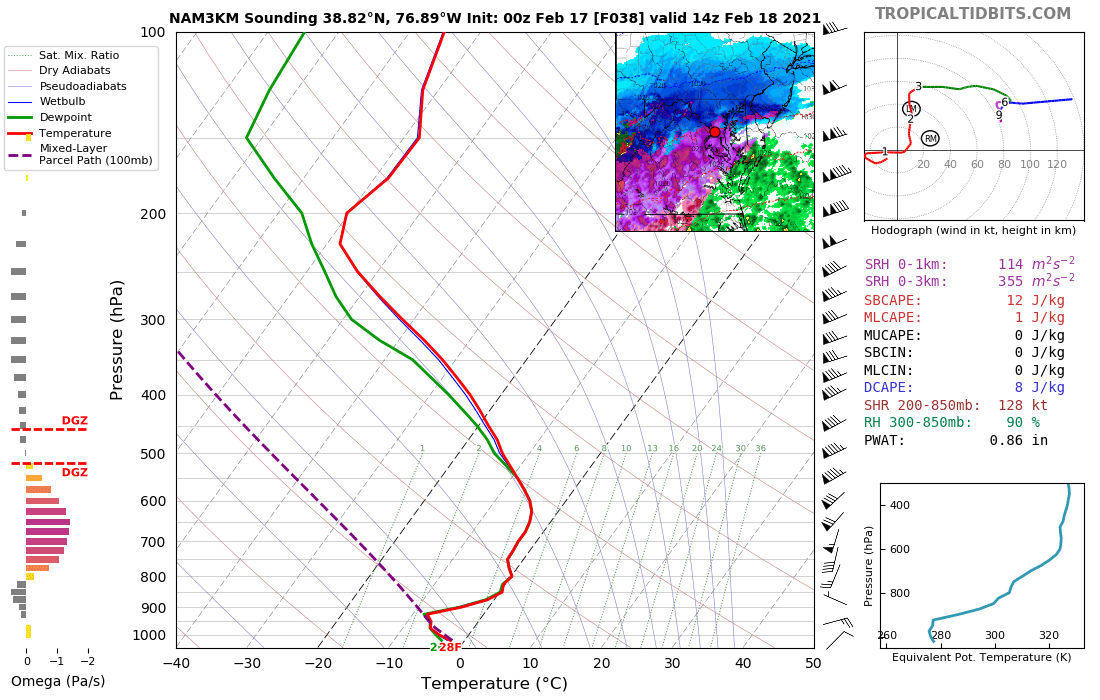
This is a sounding near DCA right as it flips to sleet at 14z. Razor thin margin.

-
Yeah that’s one of the most bizarre looking warm tongues I’ve seen. Can’t say I’d put much weight into it tbh.
-
Sleet line at 54 runs from Fairfax to Silver Spring to Annapolis to Dover, north of there is heavy snow.
-
The margin of error between a mauling and a sleetfest on the 3k NAM is less than a degree at 700 mb.
-
Yeah for sure, NAM has always been the outlier since the winds were much stronger at the mid-levels compared to other guidance. Seems to be falling in line now.
-
700 mb winds seem to be slightly weaker compared to the 6z run. Should mean slower WAA.
-
Switched over to sleet in Annapolis. Looking at 0.25-0.30” of ice accretion in the trees.
-
Annapolis, MD: 1/25: 0.3” 1/31-2/2: 3.5” 2/7: 1.3” 2/11-12: 2.5" TOTAL: 7.6” Bonus - State College PA: 12/16-17: 15.0”
-
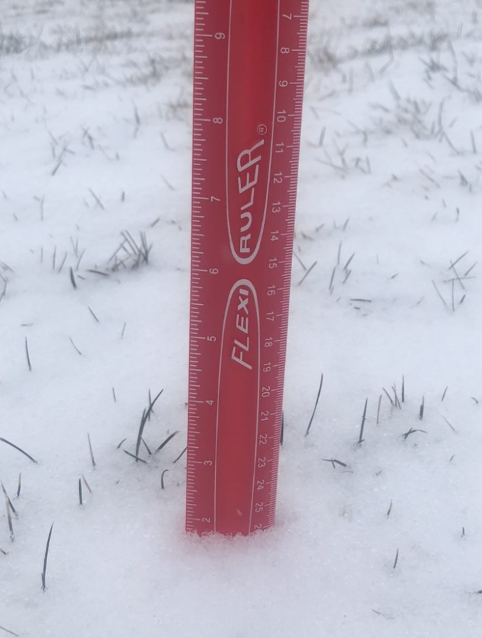
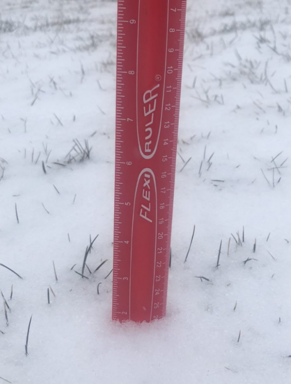
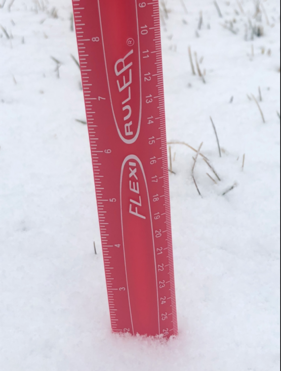
Up to 2.5” in Annapolis from this morning’s snow/graupel. Icing on the cake for a nice event.
-
Final total from my parents' house in North Wilmington is a little over 3 inches. Looks like a nice little event, that area has been fringed multiple times this winter.
-
Calling it 2 inches on the dot in Annapolis. Better than expected, so I'm pretty satisfied. Looks gorgeous outside.
-
Looks like this last band is making up for lost time in Annapolis. Woke up around 2 with basically nothing on the ground after hours of rain and sleet, but now looks like we have more snow than last weekend's fail. Will measure shortly. Congrats Baltimore/Mason Dixon Line folks who cashed in. And sorry DC...again.