

Winter Wizard
-
Posts
642 -
Joined
-
Last visited
About Winter Wizard

- Birthday 12/28/1996
Recent Profile Visitors
5,846 profile views


-

February 11-12; 12-13: Are they real??
Winter Wizard replied to stormtracker's topic in Mid Atlantic
Very slight tick north it seems with a tad weaker confluence over New England. No material changes, still 6"+ verbatim for most. -
February 11-12; 12-13: Are they real??
Winter Wizard replied to stormtracker's topic in Mid Atlantic
Seems more often than not when conventional wisdom and every pro forecaster leans one way, you'll want to bet on the opposite occurring. -
February 11-12; 12-13: Are they real??
Winter Wizard replied to stormtracker's topic in Mid Atlantic
This strikes me as a somewhat lite version of 1/6. I think most south of US 50 are good for 6"+ and 3-6" up to near the Mason-Dixon Line. Fairly straightforward setup here, main concern is surface temps being close to freezing. That, plus a progressive pattern will limit the upside and I would be skeptical of pushing double digits. Exercise caution on models currently depicting that. Certainly mindful of potential adjustments north, but not quite sold on that yet. Still, this should be another warning event for most of this forum, and will cement a pretty solid winter that was better than I think anyone could have hoped for. And still more chances to come down the line. -
Strongly agree with this call, Ray. Honestly seems like a very cut and dry forecast for this area.
-
Widespread 4-8" looks like a solid bet for most of SNE.
-
Tracking February 6. Light to moderate event potential
Winter Wizard replied to Typhoon Tip's topic in New England
I'm becoming increasingly convinced no one in SNE sees a changeover to rain. There has been a clear southward shift in the surface low and low-level cold looks to hold on strong. This could be a real mess on Thursday with a thump of snow ending as a mix.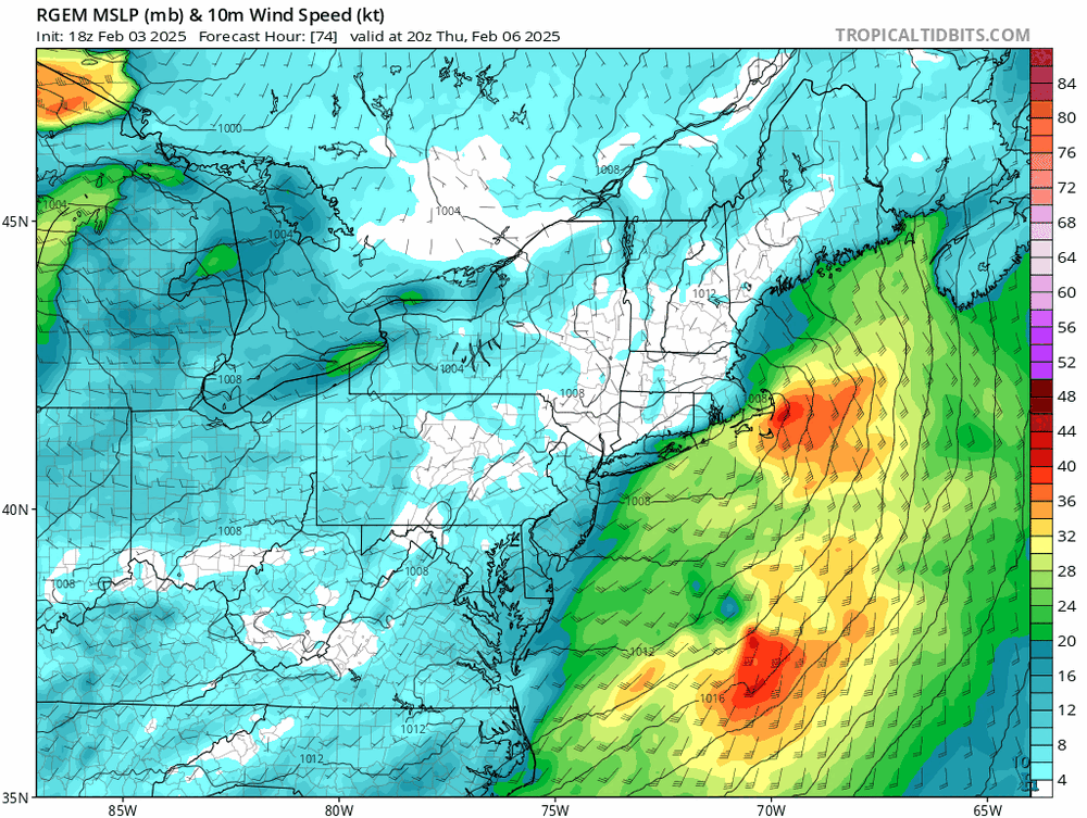
-
Everything looks to be locked in for a forum wide 6-12” event. I for one am not overly concerned about N Maryland, and in fact could see that being a secondary max given better ratios, no mixing concerns, and strong lift. That often happens on the north side of a sharp gradient. The hi-res models coming in wetter and more expansive on the northern edges do not come as a surprise to me. Regardless, looks like the best storm in years for many and well deserved. Hope you reel it in!
-
Tropical Storm Debby: Mid-Atlantic Impacts
Winter Wizard replied to WxWatcher007's topic in Mid Atlantic
CSU AI models are pretty bullish for the severe weather and tornado potential on Friday. Maybe overdone, but that is always a concern whenever a tropical system passes to your west.
-
Yeah, it's very much a pick your poison situation. A near miss for Jamaica would likely translate to worse impacts for the Yucatan. And a stronger storm is more likely to skirt northward between the eastern US ridge and central US trough, increasing the odds of US impacts. The west/weak and north/strong spread is pretty evident on the 12z models.
-
Wasn't a perfect environment but it did manage to go far enough south to dodge all the traditional early season barriers, including the area of high shear. Not to mention the consequences of record warm SSTs for this time of year.
-
It cannot be emphasized enough how unbelievable this is. Not much to say except Beryl has defied pretty much all sense of climatology and conventional wisdom. It's going to be a long season.
-
Can you provide the source of this data? Image or link?
-
Pivoting to Bar Harbor and will likely move north from there on Eclipse Day. The farther east you can get, the better I think.
-
April 8th Eclipse- Last Easy One To See In My Lifetime
Winter Wizard replied to Interstate's topic in Mid Atlantic
I decided to abandon ship in Texas and opt for New England. Logistically pretty easy to pull off, and it's hard to ignore the data. I actually think DFW area northeastward to southern Illinois could also be a sweet spot since they're between the two shortwaves. Best of luck everyone. -
I was supposed to go to Texas for this but decided to pull the plug and stick to New England. Aiming for Maine since I think the eastern side of the blocking ridge has the best odds of surviving any last second trends.


